Abstract: Appendices to IOR/R/15/1/731(1). The appendices relate to the chapter on general matters, and to the chapters on Bahrain, Kuwait, Qatar, the Trucial States, and Muscat. Also includes genealogical tables of Ruling Families in the Gulf at the end of the volume and (separately filed) further handwritten genealogical tables.Physical description: Foliation: the foliation sequence commences at 110 on the front cover and terminates at 176 on the last of the loose folios stored in polyester sheets. These numbers are written in pencil, are enclosed in a circle, and appear in the top right hand corner of the recto page of each folio. The foliation sequence is a continuation of that in the main part of the document - IOR/R/15/1/731(1).
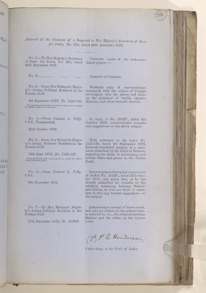
Abstract: This item consists of a copy of a Political Despatch from the Government of India Foreign Department to the Secretary of State for India, dated 26 December 1873 and received by the India office (date and department not stated), forwarding a copy of a letter concerning relations between Bahrein [Bahrain] and the tribes on the Guttur [Qatar] Coast. The Government of India confirms that it has pointed out to the Political Resident in the Persian Gulf the necessity for the Chief of Bahrein to abstain, as far as practicable, from interfering in complications on the mainland. The correspondence is chiefly that of the Political Resident in the Persian Gulf and the First Assistant Resident in the Persian Gulf. The item includes copies of a translated letter and statement of Sheik Esaw bin Ali [Shaikh ‘Īsá bin ‘Alī Āl Khalīfah], Chief of Bahrein, and the purport of a conversation between the latter and the First Assistant Resident. The despatch is in continuation of Political No. 202 dated 21 November 1873 (IOR/L/PS/6/114, ff 15-25).Physical description: Foliation: the foliation sequence for this description (used for referencing) commences at f 284, and terminates at f 294a, as it is part of a larger physical volume; these numbers are written in pencil, are circled, and are located in the top right corner of the recto side of each folio. The sequence contains five foliation anomalies: f 284a, f 288a, f 289a, f 290a, and f 294a.Condition: sections have been cut out of folios 291 and 293.
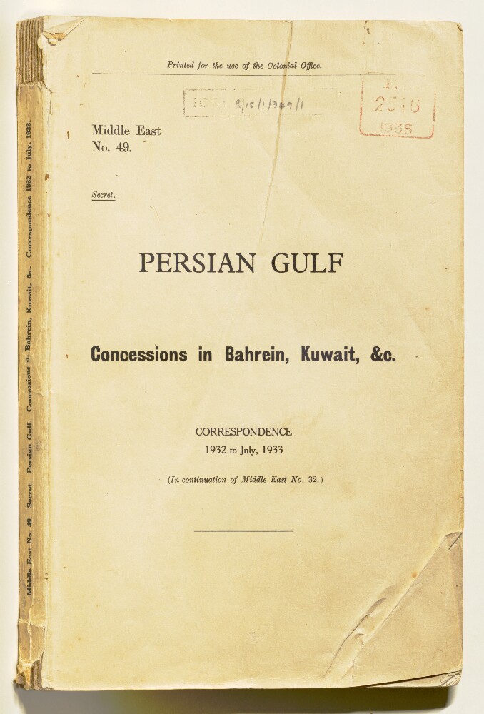
Abstract: The file consists of five volumes containing copies of oil concessions in the Persian Gulf region and correspondence between British officials related to them.1) Persian Gulf - Concessions in Bahrein [Bahrain], Kuwait &c. (sic) Correspondence 1932 to July, 1933 (folios 1-140);2) Qatr [Qatar] Oil Concession and Connected Documents; Dubai Oil Concession and Connected Documents; Sharjah Oil Concession and Connected Documents (folios 141-170);3) Memorandum and Articles of Association of Petroleum Development (Trucial Coast) Limited (folios 171-210);4) Concession Agreements with Ajman (1951), Dubai (1937), Sharjah (1937) and Umm Al Qaiwain (1945) (folios 211-300);5) Notes concerning the Abu Dhabi Petroleum Company Ltd (folios 301-306).The notes include a map of the company's pipelines and terminal facilities, a map of its air routes, a diagram of its central production facilities at Habshan and an aerial photograph of Jabal Dhanna.Physical description: Condition: A mixture of loose sheets and bound pamphlets contained in five separate volumes.Foliation: The foliation sequence runs through five parts as a single continuous sequence. This sequence commences at the first folio in part one and terminates at the last folio in part five, which is a photographic item in a polyester sheet; these numbers are written in pencil, are circled, and are located in the top right corner of the recto side of each folio. The file contains the following foliation errors: 158, and 158A; 276, and 276A.
Abstract: Al-Tuḥfat al-Nabhānīya fī tārīkh al-jazīra al-ʻArabīya (The Nabhani offering on the history of the Arabian Peninsula) is by Muḥammad ibn Kahlīfa ibn Ḥamd ibn Mūsā al-Nabhānī (1883 or 1884−1950 or 1951). The author was a teacher at the Masjid al-Ḥarām in Mecca (as was his father). The younger al-Nabhani started this work after his visit to Bahrain, and a request that he write a book treating the history of the current rulers of Bahrain, as well of its ancient emirs and their dealings with friend and foe. As the original plan had been to limit the work to the history of Bahrain, al-Nabhānī initially titled his work al-Nubdha al-laṭīfa fī al-ḥukkam min al-khalīfa (The charming fragment regarding the rulers of the house of al-Khalīfa). When the work was expanded to include the totality of the Arabian Peninsula, its name changed as well. Chapter nine of this work is a large section (with independently numbered pages) on Basra (present-day Iraq), in which al-Nabhani served briefly as judge, and in which he was imprisoned by the British during World War I. The present copy is a revised and expanded second edition, published in 1923−24 at the Maṭbaʻat al-maḥmūdīya publishing house in Cairo.Physical description: 3 volumes in 1 book ; 21 centimeters
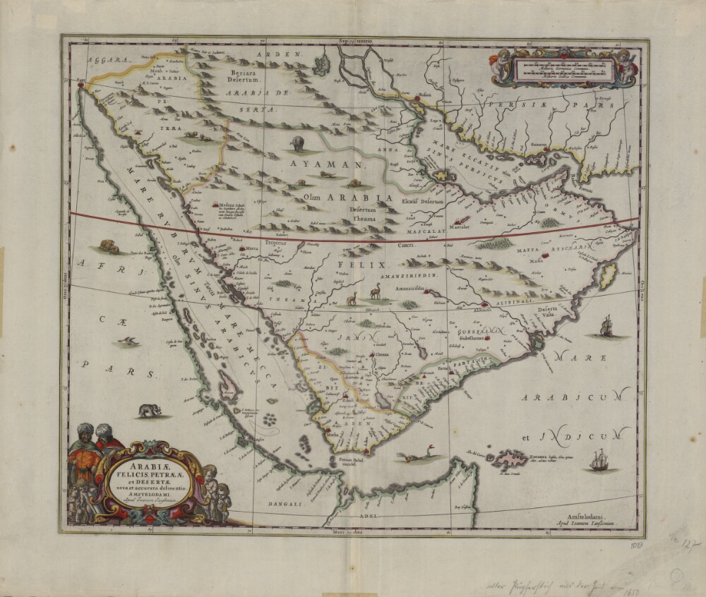
Abstract: This map from 1658 was published by Johannes Janssonius (1588-1664), or Jan Jansson. Jansson was born in Arnhem, the son of Jan Jansson the Elder, a publisher and bookseller. Jansson’s maps are similar to those of Willem Janszoon Blaeu (1571-1638), the founder of the Blaeu cartographic firm, and Jansson is sometimes accused of copying from his rival, but many of his maps predate those of Blaeu or cover different regions. This map is very similar to an earlier Blaeu map. The map shows more rivers on the Arabian Peninsula, six in total, than on many other maps. Some town names are badly copied, such as “Bocealima,” which is Blaeu’s “Roccalima.” “Mascalat” is shown as a large and important town. There are dotted lines along the coast from “Calva” in the present-day United Arab Emirates (UAE) to beyond Bahrain Island. The Arabian Gulf is called “Mare elcatif olim Sinus Persicus” (Al Qatif Sea formerly known as the Persian Gulf) and the Strait of Hormuz called “Basora fretum” or Strait of Basra. The Red Sea is called “Mare Rubrum turcis Mare Mecca olim Sinus Arabicus” (Red Sea, named Sea of Mecca by Turks and formerly known as the Arabian Gulf).Physical description: 1 map; color; 42 x 49.50 centimeters
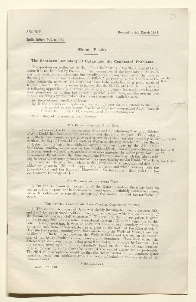
Abstract: A report concerning the demarcation of Qatar's southern boundary written by India Office representative, J G Laithwaite. The report (folios 1-4) is divided up into the following short sections:The Boundary on the South-East;The Boundary on the South-West;The Position Prior to the Anglo-Turkish Convention of 1913;The Anglo-Turkish Convention of 1913;Line Indicated in 1922 by Sir Percy Cox to Ibn Saud and Major Holmes as the Eastern Limit of any Oil Concession in Respect of Hasa [Al Hasa];I.P.C Map of February-March 1933;Conclusions as to the Southern Boundary of Qatar;Position of Area lying between Base of Qatar Peninsula and Blue Line of Anglo-Turkish Convention of 1913;Importance of Maintaining the Blue Line;Disadvantages of Maintenance of the Blue Line while Fixing Southern Boundary of Qatar at the Base of the Qatar Peninsula;Nature and Political Conditions of the Indeterminate Area;The Barr-Al-Qarah District;Conclusions.An appendix entitled Boundaries of Qatar follows the report on folios 4-5. The appendix is divided up as follows:I) Extracts from Lorimer's Gazetteer.II) Anglo-Turkish Convention of 1913 (Unratified).III) Mr. Philby's Journey of 1932.IV) Note of Discussion with Sir Percy Cox on 20th February 1934 on Question of Boundaries of Qatar.Physical description: Condition: One stapled booklet.Foliation: The file's foliation sequence commences at the first folio and terminates at the last folio; these numbers are written in pencil, are circled, and are located in the top right corner of the recto side of each folio. This is the sequence which has been used by this catalogue to reference items within the volume.Pagination: An original typed pagination sequence is also present in the file.
Abstract: Several editions of Ptolemy’s Geographia (Geography), translated into Latin from the original Greek, were published in Europe in the 15th century. This map is from the 1478 edition, which was published in Rome. Ptolemaic atlases included 12 maps of Asia. The “Sixth Map of Asia” covered the Arabian Peninsula. The outlines of this map are crude, but many geographic features, including the Red Sea, the Indian Ocean, and different features of the peninsula are clearly recognizable.Physical description: 1 map; 26 x 47 centimeters
Abstract: This map from Ptolemy’s Geographia was published in 1578 and reprinted on many occasions between 1584 and 1704. It is much more finely engraved than maps in previous Ptolemy editions. The map mentions several places in present-day Qatar (Abucei, Leaniti, Themi, Asateni, and Aegei). Names added to this edition of the map include Mesmites Sinus, Idicar, and a second Idicar, located in present-day Kuwait. This name is similar to the island of “Ichara” found near Magorum Sinus. Contemporary research has confirmed that Kharj is the island known to the ancients as “Icara.” One of the major peninsulas shown on the map is named “Chersonesi Extrema,” near Catara. Modern scholarship has identified Chersonesos as Ras Rakn in present-day Qatar. Ichtyophagorium Sinus is the gulf inhabited by the people identified in ancient histories as the “Fish Eaters.” Claudius Ptolemaeus, known in English as Ptolemy, was an ancient mathematician, astronomer, geographer, and astrologer who was born sometime after 83 A.D., most likely in a town in the Thebaid called Ptolemais Hermiou in Roman Egypt. He lived in Egypt and died in Alexandria around the year 168.Physical description: 1 map : copperplate engraving, color ; 31 x 46 centimeters
Abstract: Letter and Enclosures to HM Secretary of State for India, dated 6 December 1871.The letter encloses one from Lieutenant-Colonel Lewis Pelly, Political Resident in the Persian Gulf, to the Acting Secretary to the Government of Bombay, dated 12 September 1871. The Enclosure concerns a report from Baghdad that British vessels had intimidated people at Guttur [Qatar] and demanded payment of money on behalf of Saood [Saud ibn Faisal ibn Turki Āl Sa‘ūd, Amir of Najd]. Pelly states that the story was probably based on false reports of arrangements made in 1868 for the payment by Qatar of an annual subsidy to Bahrein [Bahrain], which formed part of a joint tribute paid to the 'Wahabee Ameer' [Amir of Najd]. The letter also encloses one from the Acting Secretary to the Government of Bombay, dated 26 October 1871, warning that the issue of sovereignty over Qatar, which arose from Pelly's letter, was one that should be taken up by the Foreign Office with the Ottoman Government.Physical description: 1 item (4 folios)
Abstract: The volume concerns British Government policy towards Qatar in the light of the bid by the Anglo-Persian Oil Company (APOC) to obtain a concession from the Shaikh of Qatar (Abdullah bin Qasim al Thani [‘Abdullāh bin Jāsim Āl Thānī]) to produce oil in the country. The British Government were keen that the concession should be obtained by a British company (APOC) and not by the Americans (Standard Oil Company of California). The oil concession was granted to APOC in 1935.The papers include: discussion of policy by various British Government departments and officials (notably the Political Resident in the Persian Gulf, Lieutenant-Colonel Sir Trenchard Craven William Fowle; the Government of India, Foreign and Political Department; and the Foreign Office); the security of Qatar against raids from the Arabian interior; relations between Qatar and Ibn Saud [Abd al-‘Azīz bin ‘Abd al-Raḥmān bin Fayṣal Āl Sa‘ūd, King of Saudi Arabia]; the decision of the British Government to offer military protection to Qatar in exchange for the granting of the oil concession to APOC (including discussions by the Committee of Imperial Defence, and its Standing Official Sub-committee for Questions concerning the Middle East); the development of air facilities in Qatar as a means of protecting the state, including correspondence from the Air Ministry; discussion of the Qatar boundary; note of a conversation between the Political Resident in the Persian Gulf and Haji Williamson (folios 147-148); the surrender to the British Government of jurisdiction over British subjects, British-protected persons, and non-Muslim foreigners in Qatar; the recognition of Shaikh Hamad as successor to the Shaikh of Qatar; British opposition to a request by the Shaikh of Qatar for machine guns and armoured cars, because of the provocative effect this would have on Ibn Saud (folios 33-35); agreement that the 1916 treaty between the British Government and the Shaikh of Qatar should be binding on his heirs and successors; and the terms on which military protection was to be afforded by the British Government (folios 12-14).The papers also include correspondence between the Shaikh of Qatar and the Political Resident in the Persian Gulf.The papers include one item of an earlier date than the main date range: a copy of the 1916 treaty between the British Government and the Shaikh of Qatar (folios 451-452).The file includes a divider, which gives a list of correspondence references contained in the file by year. This is placed at the back of the correspondence.Physical description: Foliation: the foliation sequence commences at the first folio with 1 and terminates at the last folio with 501; these numbers are written in pencil, are circled, and are located in the top right corner of the recto side of each folio. The foliation sequence does not include the front and back covers, nor does it include the two leading and ending flyleaves. A previous foliation sequence, which is also circled, has been superseded and therefore crossed out.
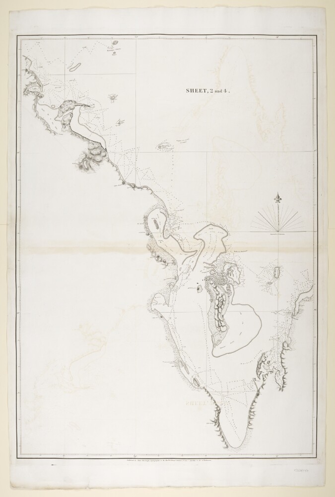
Abstract: Imprint:Published by James Horsburgh, Hydrographer to the East India Company.Distinctive Features:Relief shown by hachures. Depth shown by soundings.Nautical chart of the Arabian side of the Persian Gulf showing the coastline from Ras el Ghar with the Island of Bahrein and the western shores of the Qatar Peninsula compiled from the surveys carried out by the Bombay Marine’s officers between 1820 and 1829.Uqair in the Eastern province of Saudi Arabia labelled ‘Formerly Port to the Wahabee, Capital, Deriah’. Hawar Islands off the west coast of Qatar labelled ‘Wardens Islands’.Physical description: Dimensions:878 x 620 mm, on sheet 1019 x 677 mm
Abstract: The file contains papers regarding reported discussions among the rulers of Bahrain, Kuwait, Qatar and the Trucial States to form a federation and to gain entry into the Arab League. The primary correspondents are: Ministry of Information; India Office; Political Resident, Persian Gulf; Political Agency, Bahrain; British Middle East Office; British Embassy, Cairo.Physical description: Foliation: the foliation sequence (used for referencing) commences at the front cover with 1, and terminates at the inside back cover with 26; these numbers are written in pencil, are circled, and are located in the top right corner of the recto side of each folio.
_0001.jp2/full/!1000,1000/0/default.jpg)