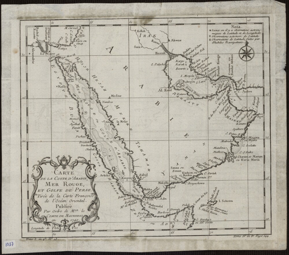
Abstract: This 1740 map is by the French cartographer and hydrographer Jacques-Nicolas Bellin (1703-72). It was published by order of Jean-Frédéric Phélypeaux, Count de Maurepas (1701-81), secretary of state under King Louis XV. The map focuses exclusively on the coastlines, and provides no detail about the interior of the Arabian Peninsula. It shows pearl banks along the coast from Bahrain to Julfar. Qatar is noted (“Katara”), but the peninsula that it occupies is not accurately drawn. Kuwait is not shown, but the island of “Peleche” is indicated. The Red Sea is indicated as Mer Rouge ou Golfe d’Arabie (the Red Sea or the Gulf of Arabia). The note at upper right explains the use of three different symbols: a star to indicate places whose locations had been determined by astronomical observations of latitude and longitude; a cross to indicate places whose locations had been determined by astronomical observations of (only) latitude; and a modified cross to indicate places whose locations had been determined by latitudinal observations made by skilled navigators.Physical description: 1 map; black and white; 20.50 x 23.50 centimeters
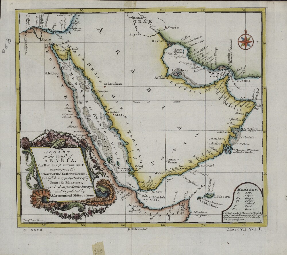
Abstract: This English map is a reprinting, with slight changes, of an earlier French map published in 1740 by order of Jean-Frédéric Phélypeaux, Count de Maurepas (1701-81), secretary of state under King Louis XV. The map was drawn from an earlier chart of the Eastern Ocean, “improv’d from particular surveys and regulated by astronomical observations.” This English edition of the de Maurepas map has a different title cartouche. The “Remarks” section at the lower right gives abbreviations for physical features on the map, and notes: “ A Stroke under ye Name of a Place denotes ye Latitude having been Observed by Astronomers, and a Prict [sic] Line by skilful Navigators.” Longitude is measured in degrees east of the “Isle de Fer” (Ferro, in the Canary Islands). Town names are as they appeared on the earlier French map. The Red Sea is listed as the “Red Sea or Arabic Gulf.”Physical description: 1 map; color; 22 x 24 centimeters
Abstract: This map of the Arabian Peninsula, published in 1720, shows Arabia Felix, Arabia Deserta, and Arabia Petraea. Other regions included are Palestine, Mesopotamia, Chaldea, Persia, Aegyptus, and Aethiopia. A large number of towns are shown. The title cartouche includes nine vignette coins. The tribal and town names on the map are those used by Ptolemy. Some are used more than once, with variations. Thus “Indicara,” “Iacara,” “Ichara,” and “Aphana” all could indicate the same place: the spot where Alexander the Great intended to build a capital on an island in the Arabian Gulf, enabling him to control the trade of the region and extend his empire (a scheme that he was unable to accomplish before he died). Archeological research suggests that this place was Failakah Island in present-day Kuwait, although some historians place it at Abu Ali Island. The map shows a peninsula near present-day Bahrain. The islands of “Arathos” and “Thylaso” indicate Muharraq and Bahrain islands, respectively, which are actually located north of Qatar. On this map, they are placed on the Persian coast side, probably because the cartographer confused them with “Hormuz” and “Qishm.” Qatar is mentioned on the map as “Catara,” but its shape and location are not accurate. The map is by Christoph Weigel, a German engraver, art dealer, and publisher.Physical description: 1 map; color; 35.90 x 29.30 centimeters
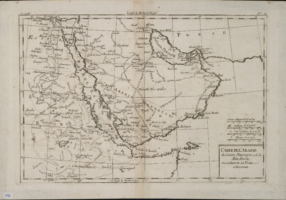
Abstract: This map of the Arabian Peninsula and surrounding areas was most likely created by the French cartographer and hydrologist Rigobert Bonne (1727−94). It is probably a proof copy of the map of the same title published in his Atlas des toutes les parties connues du globe terrestre (Atlas of all known land surfaces of the globe). The Arabian Peninsula is the main focus of the map, but it also covers much of the Nile Valley on the western shore of the Red Sea. The atlas was created to serve the global commercial and political interests of European traders and officials. Rigobert Bonne was one of many outstanding French cartographers of the 18th century. Self-taught in mathematics, he rose in the French administration to become chief hydrologist of the state Maritime Department. As a theoretician, he published a revision of global cartographic projection entitled Principes sur les mesures en longueur et en capacité (Principles of measurement of length and volume), a copy of which he sent to Thomas Jefferson in 1790 for discussion at the American Philosophical Society.Physical description: 1 map ; 21 x 31 centimeters
Abstract: Distinctive Features:Photographic copy of a map of the Qatar peninsula attached to the Bahrain Express Letter No. C/49 dated 11th January 1942 (folios 2-3) to illustrate the question of the south eastern boundaries with Saudi Arabia.Shows the proposed concession boundary line with roads and distances reported; location of wells with fresh water marked.Physical description: Materials:Photographic printDimensions:658 x 447 mm
Abstract: Map depicting the south-eastern part of the Arabian Peninsula. Several lines have been drawn on the map by hand to show the existing or proposed boundaries of south-eastern Arabia, Qatar and Abu Dhabi. Published by the Geographical Section, General Staff.Physical description: Materials: Printed in colour on paper, with manuscript additions in pencil and ink.Dimensions: 310 x 283mm, on sheet 415 x 283mm.
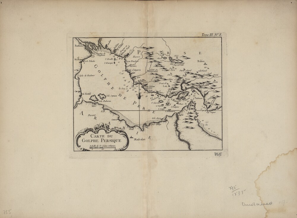
Abstract: This map of the Persian Gulf is by the French cartographer Jacques-Nicolas Bellin (1703−72). Qatar is shown as Catura. Cities on both the Arabian and Persian sides of the gulf are indicated, and the map shows a river emptying into the gulf at the port of Julfar (present-day Ra's al-Khaymah, United Arab Emirates). The scale is in common leagues, and there are no latitudinal or longitudinal lines. Trained as a hydrographer, Bellin was attached to the French Marine Office and specialized in producing maritime maps showing coastlines. His maps were in the tradition of Nicolas Sanson (1600–1667), the royal geographer to Kings Louis XIII and Louis XIV commonly known as the father of French cartography, and of Guillaume de l'Isle (1675−1726), one of a group of French cartographers that wrested mapmaking preeminence from the Dutch in the late 17th century. Like Sanson and de l’Isle, Bellin placed great emphasis on scientific accuracy rather than on artistic beauty for its own sake. In 1764, he published Le Petit Atlas Maritime: Recueil de Cartes et de Plans des Quatre Parties du Monde (Small maritime atlas: collection of maps and charts of the four parts of the world), a work in five volumes containing 581 maps. This map appeared as plate 8 in volume 3 of this work, containing maps of Asia (part I) and Africa (part II).Physical description: 1 map : copper engraving ; 22 x 17 centimeters
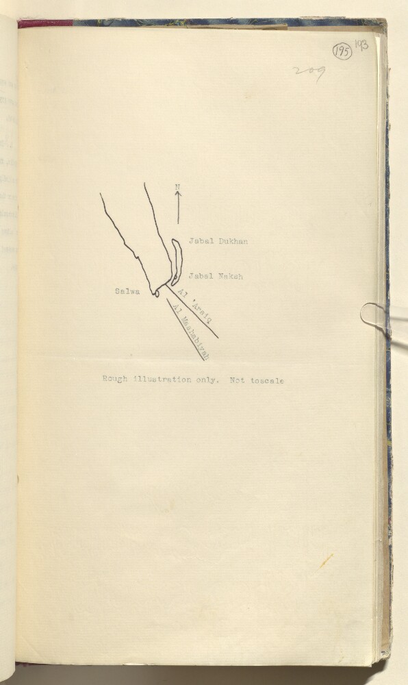
Abstract: Distinctive Features:Hand drawn sketch map showing Dawḩat Salwá and area west of Salwa, attached to a letter No. C/38-1.a/38 dated 25 January 1936, to illustrate a dispute concerning Saudi-Qatar boundary.Physical description: Materials:Pen and ink on paperDimensions:328 x 185 mm
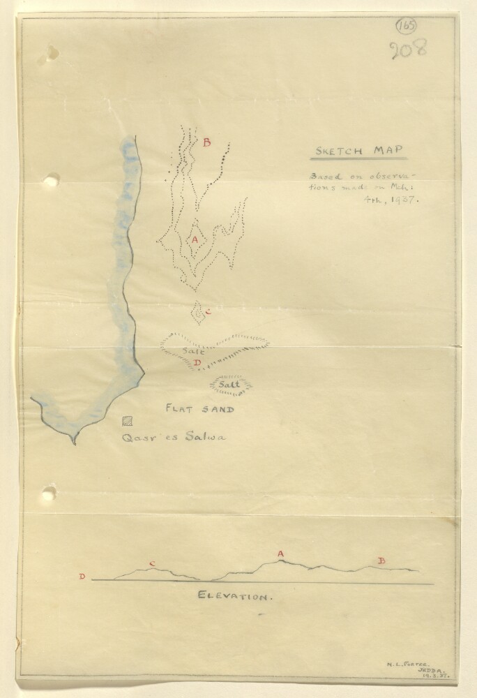
Abstract: Distinctive Features:Relief shown by hachures.Tracing of a rough sketch map based on observations made on 4th March 1937, showing area north of Qasr es Salwa in Qatar with landmarks lettered for reference. Includes corresponding elevation profile in the lower portion of sheet.Signed and dated in the bottom right-hand corner: ‘N.L. Forter, Jedda, 19.3.37’.Physical description: Materials:Pen and ink with wash on tracing paperDimensions:293 x 194 mm
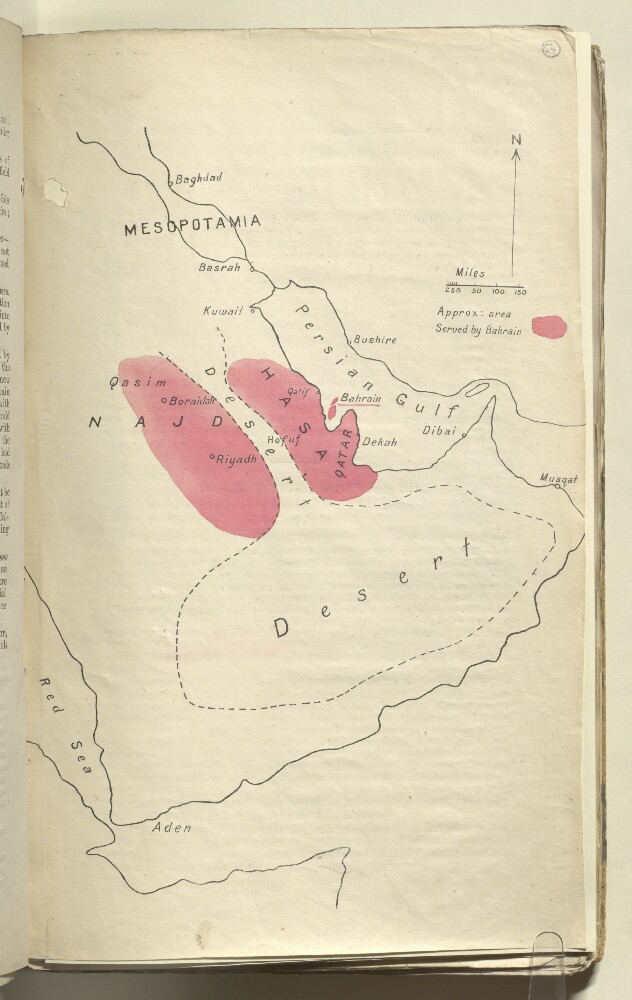
Abstract: A sketch map prepared for the Bahrain Political Agent to illustrate the area of the Arabian Peninsula — shown in pink — served by trade with Bahrain.Physical description: Materials: 1 paper folioDimensions: 332 x 206mm
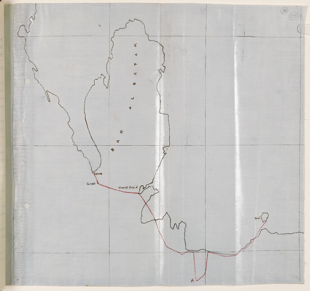
Abstract: Distinctive Features:Unsigned and undated.Hand-drawn map with the route of the Qatar Air Reconnaissance carried out by Lieutenant-Colonel Gordon Loch on 29th June 1934 shown by red line.Physical description: Materials:Pen and ink on tracing clothDimensions:322 x 335 mm
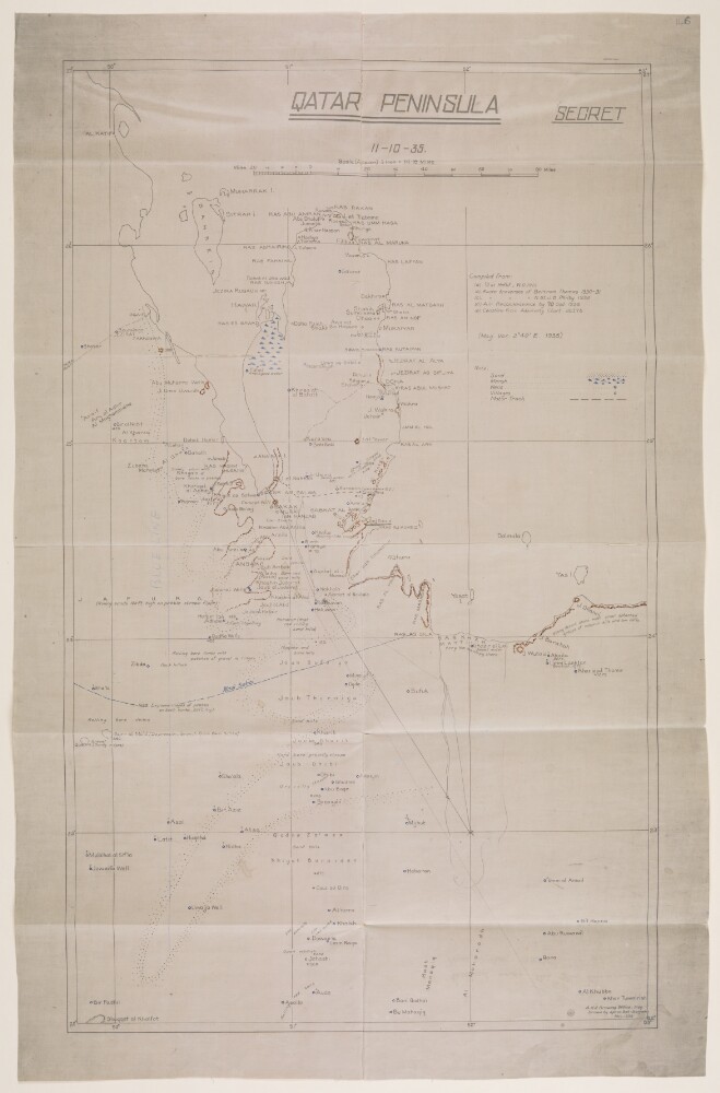
Abstract: Imprint:A.H.Q. [Air Headquarters] Drawing Office Iraq. Drawn by Aprim Bet-Benjamin, Nov. 1935.Distinctive Features:Relief shown by hachures.Map showing the Qatar Peninsula and central part of the Eastern Province Saudi Arabia. Numerous notations concerning terrain features cover the face of the map with routes, the location of wells with good water, and sandy and marshy areas marked.Includes a key to symbols and a list of sources used in compilation of the map.Inscriptions:On verso is an annotation in black ink: ‘Received under Air Officer Commanding, British forces in Iraq’s letter No. S. 10843/2411 dated 19th November 1935; file 61/31. With initials and date ‘12/12/35’.Physical description: Materials:Photographic print with additions in ink and crayon on tracing clothDimensions:592 x 357 mm, on sheet 670 x 431 mm