Abstract: Imprint:Reduced and lithographed in the Chief Engineer’s Office by Kumbroodeen E. & F.D. Jesus, Bombay 3d Oct.r 1855.Distinctive Features:Plan originally produced to accompany a report on Bassadore prepared by Captain Thomas Remon, Bombay Engineers.Depth shown by soundings in fathoms with areas partly dry at low water indicated.Along the top a birds-eye view of the settlement with landmarks labelled.Physical description: Dimensions:313 x 248 mm, on sheet 350 x 286 mm
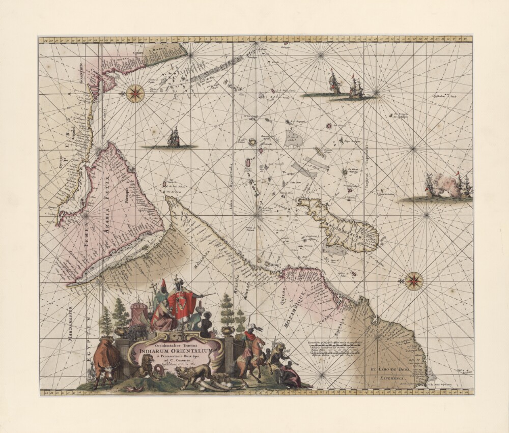
Abstract: This portolan map by the Dutch engraver, publisher, and map seller Frederick de Wit (1629 or 1630-1706) shows the Indian Ocean from the Cape of Good Hope to the west coast of India (Malabar). The map was first published in 1675 and was reprinted in 1715. It is oriented with east at the top. Kishm is placed in the present-day United Arab Emirates (UAE) and repeated as “Quaro” and “Quiximi.” The shape of the Arabian or Persian Gulf differs from that shown on other maps. There is a big island north of Bahrain Island named “Quezimi,” most likely another version of Qishm. Khorfan is shown twice: at one location in the present-day UAE in the Gulf of Corsca and the second on the Omani side, where it is called “Orfacan.” Mascalat, the region, is located at the center of the Arabian Peninsula, while the town of the same name is found south of Tablan, not far from the Arabian coast. “Ormuz,” a territorial name, is found around Oman and the present-day UAE. The Arabian Gulf is called “Mare Elcatif ol Sinus Persicus” (Al Qatif, Persian Gulf), while the Red Sea is marked “Mare Rubrum turcis Mare de Mecca olim Sinus Arabicus” (Red Sea, named Sea of Mecca by Turks and formerly known as the Arabian Gulf).Physical description: 1 map; color; 42 x 53.5 centimeters
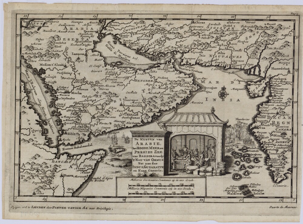
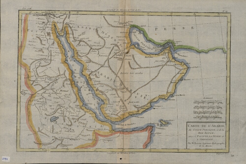
Abstract: This 1707 map of the Arabian Peninsula and adjacent regions is the work of Pieter van der Aa (1659-1733), a Dutch publisher and bookseller based in Leiden who specialized in reissuing maps acquired from earlier mapmakers. The map appears to be based on an earlier Portuguese work, and uses a mix of Dutch, Latin, and Portuguese for titles and place names. The map covers only the eastern and central parts of the peninsula, which is shaped differently than shown on many other maps. The map shows four rivers on the Arabian (western) side, but they reach more deeply into the peninsula than on other maps. The map gives three names for Al Ahsa: “Ahsa,” “Labsa,” and “Lessa.” The Arabian Gulf is called the Persian Gulf or Gulf of Basra. The Strait of Hormuz is called Fretum Bassora or Strait of Basra.Physical description: 1 map; black and white; 14 x 21.50 centimeters
Abstract: This part of the volume consists of copies of enclosures to a despatch from the Government of Bombay Secret Department to the Secret Committee, Number 29 of 1853, dated 28 April 1853. The enclosures are numbered 3-16 and are dated 1 December 1852-21 April 1853.The papers relate to the march of a Wahabee [Wahhābī] force from Nedjd [Najd] to Brymee [Buraymi] in Oman via Guttur [Qatar].The correspondents are the Resident in the Persian Gulf (Captain Arnold Burrowes Kemball) and the Chief Secretary to Government, Bombay.Physical description: 1 item (69 folios)
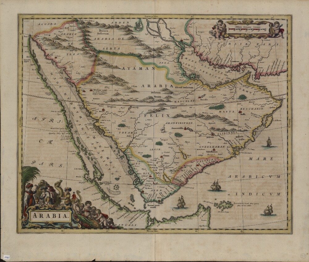
Abstract: This 1662 Latin map of Arabia is a copy of an earlier map by Willem Janszoon Blaeu (1571-1638), the founder of the Blaeu cartographic firm. It is one of the first maps to show internal features of the Arabian Peninsula. Mountains are depicted, oases denoted by trees, and points used to indicate pearl deposits in the Arabian Gulf. The map uses dotted lines to show international borders. The Red Sea is denoted by three Latin names: Mare Rubrum (Red Sea), Mare Mecca (Sea of Mecca), and Sinus Arabicus (Gulf of Arabia). The Blaeu firm published the first edition of the Atlas Novus (New atlas) in 1635. Sons Joan (1596-1673) and Cornelis (died 1648) took over the firm after their father’s death and continued to produce expanded and improved editions of the atlas.Physical description: 1 map; color; 40 x 51 centimeters
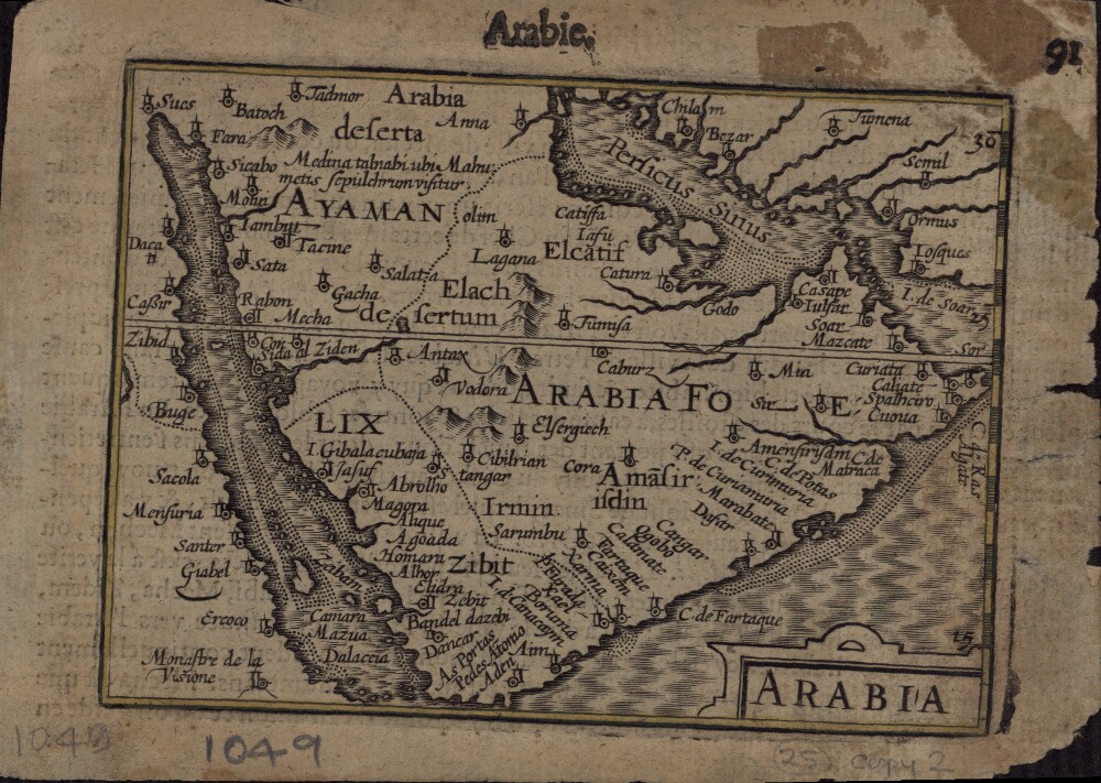
Abstract: This 1616 map is a reprint of a map originally published in 1598 by Jodocus Hondius (1563-1612), a Flemish cartographer and engraver who settled in Amsterdam in about 1593 and established a business that produced globes and the first large maps of the world. The map covers the territory from west of the Gulf of Suez to the eastern side of the Arabian Peninsula, and from the mouth of the Euphrates River to Aden. The only cities indicated on the western coast of the Persian or Arabian Gulf are Qatar (“Catara”), “Godo,” and “Catiffa.” The map shows sandbanks around the coast and rivers at Medina and Mecca. Few towns and regions are shown, and there is a range of mountains in the center of the peninsula. Al Qatif is repeated as the town “Catiffa” and the region “Elcatif.” The peninsula opposite Bahrain Island, shown unnamed, is marked as where “Catara” is found. The commonly noted rivers of the Arabian coast are shown as very close together. The Arabian Gulf is called “Persicus Sinus” (Persian Gulf) and there is no name given for the Red Sea. The Ayaman area is shown as the most populated area on the map. The cartographer uses castles to denote cities and dotted lines to show the division of the Arabian Peninsula into three parts.Physical description: 1 map; black and white; 11.60 x 8.50 centimeters
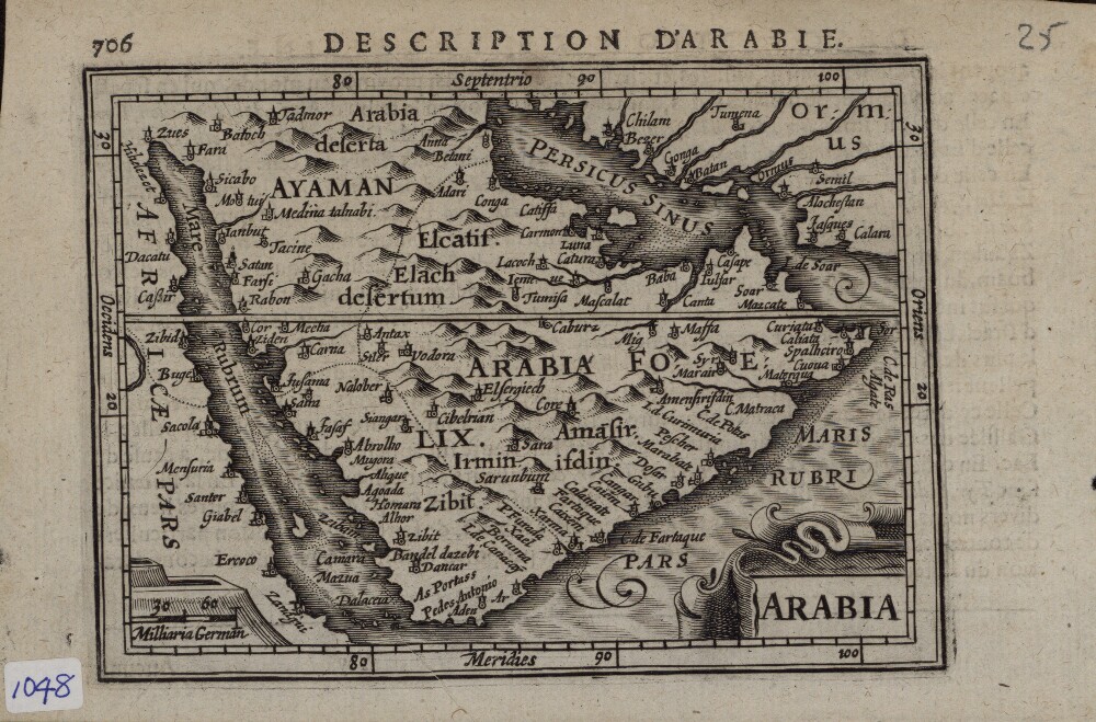
Abstract: This map of 1616, with Latin place names, is a reprint of a work by Jodocus Hondius (1563-1612), a Flemish cartographer and engraver who settled in Amsterdam in about 1593 and established a business that produced globes and the first large maps of the world. The place names on the map are unclear. “Coromanis” is shown on many older maps as located in present-day Kuwait, but here is shown as lying beyond “Catiffa,” or Al Qatif. “Luna,” on the coastal belt of the Arabian Gulf, could be Ras Tanurah, located near “Carmonis.” (Some historians believe that “Carmon” or “Carmonis” is derived from the Arabic name, Khor Omani, which various maps show at different points on the coast of the Arabian Gulf.) This place also could be “Cor Bobian,” or the Arabic Khor Bobian. A town with the strange name of “Baba” is shown adjacent to a river placed on the territory of the present-day United Arab Emirates. Beyond Julfar is “Cassape,” a name that is not understood by modern scholars. Qatar and Bahrain are ambiguously represented on this map, and difficult to identify.Physical description: 1 map; black and white; 8.50 x 12.10 centimeters
Abstract: John Tallis and Company was a British mapmaking and publishing firm, founded by John Tallis (1817–76), which was active in London circa 1835−60. Tallis maps were known for their accurate information with numerous place-names and geographical details, as well as for the use of shaded areas to indicate topographical features. They are identifiable by the scrolling on the borders and the finely-drawn scenes inscribed on the margins of the maps, which John Tallis and his illustrators derived from travelogues and other written sources. John Rapkin (1815−76) was the principal engraver for the firm, who drew and engraved most Tallis maps. This map of Arabia by Rapkin shows physical features, towns and villages, and caravan routes across the desert, many leading to the holy city of Mecca. The geographic extent of the region defined as Arabia is marked with a red line, and includes not only the Arabian Peninsula but parts of present-day Egypt, Jordan, and Syria. Illustrations in the four corners of the map show a camel beneath a palm tree, Arab women carrying water jars, Mount Sinai, and two Arab men, one on horseback and another on foot. The illustrations were drawn by H. Warren and engraved by John Rogers, who produced numerous steel engravings for Tallis.Physical description: 1 map ; 26x 32 centimeters
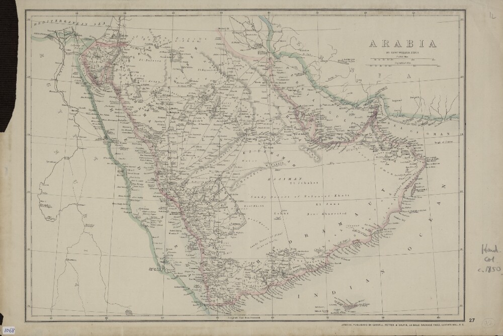
Abstract: This map of the Arabian Peninsula shows international borders, caravan routes, and important cities and towns. British possessions, including the port of Aden and the island of Socotra (ʻAdan and Suquṭrā, both part of present-day Yemen), are indicated by the pink coloring. The old Qatari cities of El Bedaa and Zabara (present-day Al Bida and Al Zabara) are shown. The map appeared as plate 48 in The Imperial Atlas of Modern Geography, published by the Glasgow firm of Blackie & Son in 1859 and reissued in 1860. Founded in 1809 by the Scot John Blackie (1782−1874), by the mid-19th century this firm was an important publisher of illustrated reference works, including The Imperial Gazetteer (1855), The Imperial Atlas of Modern Geography, and The Imperial Bible Dictionary (1866). The map was drawn and engraved by Edward Weller (1819−84), a London-based cartographer and engraver who was the unofficial geographer of the Royal Geographical Society in London. The atlas was compiled under the direction of Walter Graham Blackie (1816−1906), the youngest son of John Blackie.Physical description: 1 map : hand colored ; 33 x 49 centimeters
Abstract: The correspondence contained in the letter book relates primarily to affairs in Muscat from 1866 to 1868 during which time the Sultan of Muscat, Thuwaini bin Said died, allegedly killed by his son Salim II bin Thuwaini who subsequently seized power in Muscat before being overthrown in 1868 by his uncle Turki bin Said.Also covered in the correspondence are affairs relating to piracy in Bahrain 1867 to 1868 and the maritime peace treaties signed with various rulers in settling matters, including the treaty signed with Mohammed bin Thani, Chief of the Qatar tribes.Physical description: Foliation: The volume has been foliated in the top right hand corner of the recto of each folio with a pencil number enclosed in a circle.Pagination: The volume also contains original pagination in the first half of the volume which consists of an ink number in the top right hand corner of the recto and the top left hand corner of the verso of each folio. The numbers start on the first page of writing with 1 and runs to 177, located on the recto of folio 96.
Abstract: The letterbook contains copies of letters from Lewis Pelly to colleagues in the Persian Gulf, India and England, on a number of subjects relating to the role and responsibilities of the Political Resident in the Persian Gulf including the Residency's relations with Persia, its role in keeping the maritime peace and arbitration of disputes, and the growth of trade in the region, as well as British interest in local trades such as pearling.The main correspondence is with the Government of Bombay, including letters to both Sir Bartle Frere and Sir William Robert Seymour Vesey Fitzgerald, the consecutive Governors of Bombay during the period the letterbook covers. This correspondence relates primarily to matters in Muscat, where successive changes in rulership have led to instability, and Bahrain and Qatar where the actions of the tribes in attacking ports and British subjects result in naval action being taken against them by the British authorities.The residency's relationship with the Persian authorities is also discussed both in correspondence with the Government, and with Charles Alison, the British representative in Tehran as there are a number of decisions by the Persian authorities during this period which restrict both trade through the Persian ports and the residency's ability to communicate with Persian authorities along the Persian coast.Other matters discussed in the volume include the day to day operations of the residency, with correspondence to James Charles Edwards, the uncovenented assistant resident, as well as with arrival new staff, recently appointed to the Residency to work alongside Pelly including Edward Charles Ross and George Andrew Atkinson at Muscat, Abraham Nickson Hojel at Bushire, Henry W Warner at Gwadar and Alfred Cotton Way as the political agent for the southern Gulf.Other correspondence of interest includes a number of letters to the commanders of marine vessels in the Gulf, correspondence with individuals involved in the development of telegraph and steamer communications throughout the Gulf, and correspondence with Sir Clement Markham and Sir Roderick Murchison discussing the acquisition of samples of shells, pearls, oysters and rocks both for geological interest and to assist in attempts to refresh the pearl beds in Ceylon (Sri Lanka).The reverse of the volume, which has been turned over, so the writing appears upside down in relation to the folio numbers, contains correspondence relating to Pelly's finances in relation to the collapse of the Bank of Bombay, the liquidation of the Commercial Bank and the establishment of the new Bank of Bombay. The majority of this correspondence is with Messrs Remington & Co and Narayn Wussadeojee, who handled his affairs in Bombay; and Messrs Smith, Elder & Co who handled his affairs in England.Also included in the volume, on folio 193v, is the address of G Lejean, a Paris restaurateur.Physical description: Foliation: The volume has been foliated in the top right corner of the recto of each folio using a pencil number enclosed in a circle. Some renumbering has taken place and the folio numbers which are no longer in use have been crossed through.
Abstract: This file contains correspondence between British officials regarding the provision of medical facilities on the Trucial Coast including the political reasons for doing so. Specifically, the correspondence discusses the opening of a medical dispensary in Dubai in June 1939.The file also contains a limited amount of correspondence related to the opening of an American Mission hospital in Qatar in 1947.In addition to this correspondence the file contains the following documents:'Report on Dibai [Dubai] Dispensary' (folios 73-74)'Statement showing estimated cost of dispensary on the Trucial Coast' (folio 127).The file includes a divider, which gives a list of correspondence references contained in the file by year. This is placed at the back of the correspondence.Physical description: Foliation: the foliation sequence (used for referencing) commences at the front cover with 1, and terminates at the inside back cover with 129; these numbers are written in pencil, are circled, and are located in the top right corner of the recto side of each folio.