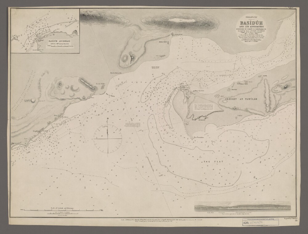
Abstract: Chart 35.Hydrographic chart covering the port of Basiduh [Basaidu] on Qeshm Island, Persia [Iran]. Also depicts the western part of Clarence [Khuran] Strait, the Persian Gulf and a fifty-mile length of the Persian mainland coast. Portrays hydrology, including depths by soundings and contours, sands, mud, rocks and anchorages, relief by spot heights, hachures and rock drawings, vegetation, cultivation, settlements, public buildings and place names, and includes topographical notes and navigational aids, including beacons and prominent buildings. The sheet also includes an inset of Basiduh Anchorage at scale 1:60,500 and an annotated sketch view, at an unspecified scale, of the approach to Basiduh from the south-east.The margins have been trimmed, with some information lost.Chart surveyed by Commander Charles Golding. Constable, Indian Navy, and assisted by Lieutenant Arthur William Stiffe, Indian Navy, 1858-60. Soundings in 'hair line' from a survey by Commander George Barnes Brucks and Lieutenant Stafford Bettesworth Haines, Indian Navy, 1828. Engraved by Edward Stanford. Published at the Admiralty 1867, with corrections 1868 and 1869.Physical description: Materials: Printed on paperDimensions: 457 x 625mm, on sheet 484 x 643mm
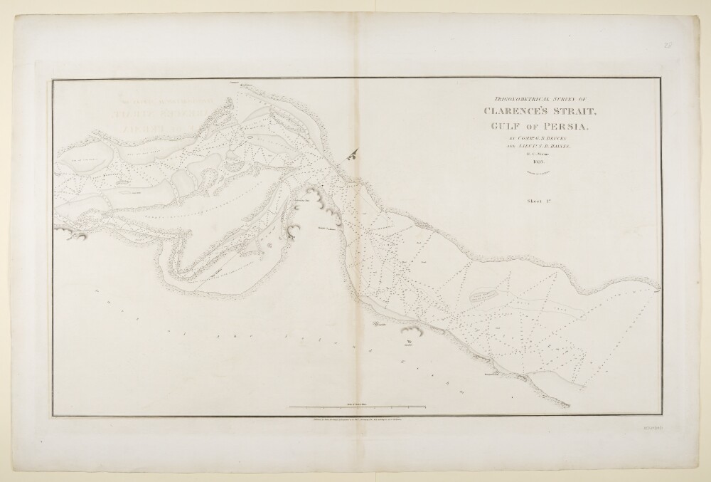
Abstract: Imprint:Published by James Horsburgh, Hydrographer to the East India Company.Distinctive Features:Relief shown by hachures. Depth shown by soundings.Nautical chart of the Clarence Strait in the Persian Gulf compiled from the surveys carried out by the Bombay Marine’s officers between 1820 and 1829. Depicts the coastline of the mainland and the northern shores of the Island Kishm [Qishm] with the location of ‘Inderabia Fort’, a mosque and a house marked.Continuation of the map entitled ‘Sheet 2’ is held at IOR/X/3630/28/2.Physical description: Dimensions:497 x 902 mm, on sheet 679 x 1025 mm
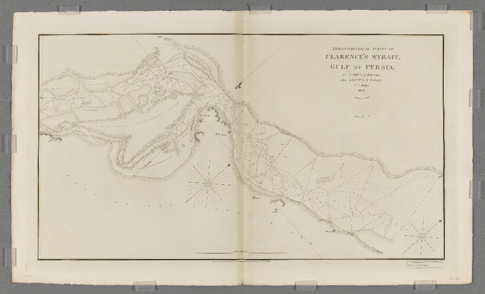
Abstract: Covers a thirty-five-mile length of the central portion of Clarence's Strait [Toreh-ye Khuran and Toreh-ye Khvoran] and the adjacent coastlines of southern Persia [Iran] and Kishm Island [Qeshm Island, Iran], together with a hinterland of approximately half a mile. Portrays hydrology, including depths by soundings, sands and rocks, relief by hachures, vegetation, settlements and place names, and includes topographical and hydrographic notes.Surveyed by Commander George Barnes Brucks and Lieutenant Stafford Bettesworth Haines, 1828. Engraved by Richard Bateman. Published by James Horsburgh, Hydrographer to the Honourable East India Company.An accompanying sheet (Sheet 2nd) is filed at IOR/X/3630/28/2.Physical description: Materials: Printed on paperDimensions: 496 x 898mm, on sheet 610 x 1020mm
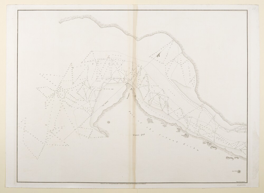
Abstract: Imprint:Published by James Horsburgh, Hydrographer to the East India Company.Distinctive Features:Relief shown by hachures. Depth shown by soundings.Nautical chart of the Clarence Strait in the Persian Gulf compiled from the surveys carried out by the Bombay Marine’s officers between 1820 and 1829. Depicts the coastline of the mainland and the western part of the Island Kishm [Qeshm] with areas dry at low water stippled and indicated by a dotted line.Continuation of the map entitled ‘Sheet 1’ is held at IOR/X/3630/28/1.Physical description: Dimensions:526 x 699 mm, on sheet 562 x 774 mm