Abstract: This file consists of a note, written by Sir Dennis Fitzpatrick, member of the Council of India, on the subject of the northernmost portion of land in the province of Baluchistan [Balochistān], south of the Durand line, which is described as being situated between British India and Kelat [Kalat] on the east side, and Persia on the west side.The note begins by referring directly to the following letter of correspondence: 'Letter from India, No. 189, Secret,' dated 19 October 1899. The note is principally concerned with the costs and benefits of a proposed railway line, which would run from Nushki (recently taken over by the British from the Khan of Kelat) to Koh-i-Malik-Siah [Malek Sīāh Kūh], in Seistan [Sīstān].The file questions the argument that such a railway line would counteract Russian influence in Seistan. Also discussed is the extent to which the Government of India should be expected to finance such a scheme. Fitzpatrick makes the argument that it is wider Imperial interests, rather than those of the Government of India, which are most at stake, and that therefore a distribution of the cost should be made by fixed shares, rather than by relying solely on Indian revenues. He concludes by referring to a note that he wrote some months earlier, in which he advised that the control of all British affairs west of Baluchistan and Afghanistan should be vested exclusively in the Foreign Office.Physical description: Foliation: the foliation sequence commences at the first folio, and terminates at the last folio; these numbers are written in pencil, are circled, and are located in the top right corner of the recto side of each folio.Pagination: the volume also contains an original printed pagination sequence.
Abstract: The volume is titled
Report on the Working of the Line of Communication and on the Withdrawal of the British Military Mission in East Persia, General Staff India. The volume is marked confidential and was printed in Delhi by Superintendent Government Printing, India, in 1921.The report is from the General Officer Commanding, Baluchistan District to the Chief of the General Staff; the report contains preliminary remarks on 'The withdrawal of the troops of the British Military Mission at and beyond Meshed, and of the Lines of Communication'. There follows the substantive report from the Inspector-General of Communications, East Persia, Duzdap to the General Staff, Baluchistan District, Quetta. This report is divided into two parts:Part I - 'A brief report on the working and organization of the Line of Communications, East Persia, in April 1920'Part II - 'The withdrawal' which has the following sub-sections: general; supply and transport services (including some special points for consideration); medical; ordnance; works; posts and telegraphs; vetinary.The report is accompanied by nine maps:'APPENDIX 1. SKETCH MAP SHOWING POSITION OF POST AND COMBINED OFFICES IN EAST PERSIA' (folio 10)'APPENDIX 1. L. OF C.E.P. INTELLIGENCE SYSTEM' (folio 12)'APPENDIX 2. AREA ON THE EAST PERSIA L. OF C. COMMON TO RAIDING (folio 15)'APPENDIX 1. GRAPHIC MAP ILLUSTRATING THE NORMAL SOURCES FROM WHICH THE TROOPS IN EAST PERSIA WERE SUPPLIED AND THE CONTINUOUS MOVEMENTS BY WHICH THE SUPPLIES WERE NORMALLY DISTRIBUTED TO THE FORCE AT MESHED AND TO THE GARRISONS OF POSTS ON L. OF C.' (folio 18)'APPENDIX 1. LINES OF COMMUNICATION EAST PERSIA' (folio 33)'APPENDIX 3. DIAGRAM SHOWING POSITIONS OF TELEPHONE, TELEGRAPH AND COMBINED OFFICES IN EAST PERSIA' (folio 35)'COLUMNS AND CONVOYS WOKRING IN CONNECTION WITH WITHDRAWAL FROM EAST PERSIA' (folio 55)'DAYS AFTER ZERO' (folio 62)'PLAN showing ORGANIZATION OF LINE OF COMMUNICATIONS (ADMINISTRATIVE AND DEFENCE TROOPS) (folio 77)Physical description: Foliation: the foliation sequence for this description commences at the front cover with 1, and terminates at the inside back cover with 78; these numbers are written in pencil, are circled, and are located in the top right corner of the recto side of each folio.Pagination: the volume also contains an original printed pagination sequence.
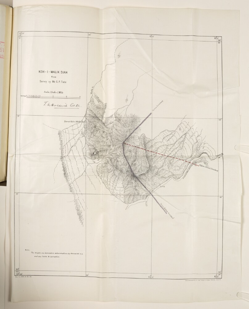
Abstract: Map of the mountain Koh-i-Malik Siah (also referred to as Malik Siah Koh in file) [Malek Sīāh Kōh] and surrounding area, around the frontiers of Afghanistan, Persia [Iran] and Baluchistan [in present-day Pakistan], produced from a survey made by George Passman Tate. The map is signed by Colonel Thomas Hungerford Holdich, Royal Engineers. The map indicates: topography, with an indication of relief; heights for two summits, expressed in feet; the Afghan-Baluch boundary, marked as a red dashed line; the Perso-Baluch and Sistan boundaries, marked as solid mauve lines.A note on the map states that heights indicated on the map are barometric determinations by Ahmad Kali, and are liable to correction. A printing statement in the bottom right of the map states: ‘Heliozincographed at the Survey of India Offices, Calcutta [Kolkata].’Physical description: Dimensions:455 x 390 mm, on sheet 550 x 430 mm.Materials:printed on paper.
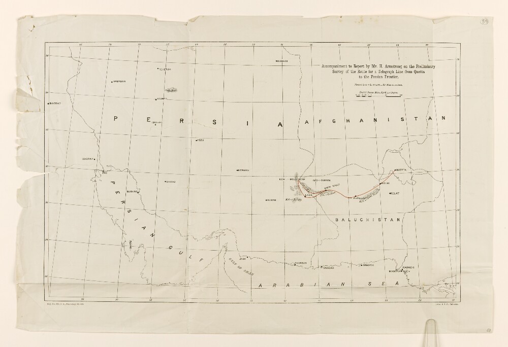
Abstract: The map shows parts of countries including Iraq, Persia [Iran], and Afghanistan, the region of Baluchistan [Balochistan], the Persian Gulf, and the Northern coastline of the Arabian Sea. The route of a proposed telegraph line from Quetta to Ladis and Koh-i-Malik Seah is indicated with a red line.The map includes some indication of relief, in the form of hachures for volcanoes and mountains.Physical description: Materials: Printed on paperDimensions: 316 x 506mm, on sheet 387 x 579mm
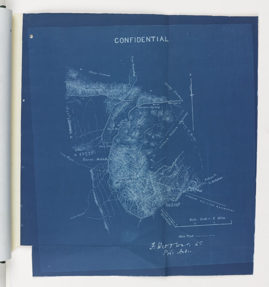
Abstract: The blueprint map shows the point at which the Afghan Persian Boundary, the Afghan British Boundary, and the Baluch Persian Boundary meet at Koh-I-Malik Seah [Malik Siah Koh or Malek Sīāh Kōh] mountain. Relief is indicated by contours.It is headed ‘Confidential’ and is signed by Lieutenant Frank Webb Ware, Political Assistant, Chagai. It forms part of a ‘Report on the Baluch-Persian Caravan Route and Nushki, Chagai and Western Sinjerani Districts, by Webb Ware, dated 1897 (folios 22-54 of Mss Eur F111/350).Physical description: Materials: Blueprint paperDimensions: 355 x 320mm