1 - 4 of 4
Number of results to display per page
Search Results
1. 'File 86/1 VII (D 101) Kuwait Oil'
- Description:
- Abstract: The volume contains correspondence between the Political Agent at Kuwait (Harold Richard Dickson); Political Resident in the Persian Gulf (Trenchard Craven Fowle); His Majesty's Minister at Jedda (Sir Andrew Ryan); Officials in the India and Foreign Offices (including Sir Louis Kershaw, John Gilbert Laithwaite, George Rendel); the Shaikh of Kuwait (Shaikh Aḥmad al-Jābir Āl Ṣabāḥ); the Air Ministry (Wilfred Ashton McLaughry); the Air Office Commanding, Iraq (Alexander Duncan Cunningham); and representatives of the Kuwait Oil Company (Frank Holmes, Archibald Chisholm), Arabian Development Syndicate, Anglo-Persian Oil Company, and Iraq Petroleum Company.The correspondence relates primarily to the Kuwait Oil Company's negotiation's with His Majesty's Government and the Shaikh of Kuwait for the Kuwait (also given as Koweit) Oil Concession, focusing on discussions around clauses in both the Commercial and Political Agreements and the Shaikh's concerns over how certain clauses may be perceived both within his own country and in neighbouring ones.Also discussed are developments in Saudi Arabia with regards to their share of the Nejd-Kuwait Neutral Zone Oil Concession, which was being competed for by the Standard Oil Company of California and the Arabian Development Syndicate, and the British Government's opinions on the situation and their intended approach with regards to the Kuwait share of the concession. The information relating to the Saudi Government's approach to the concession is relayed through letters and reports from Sir Andrew Ryan, HM Minister at Jedda, and contain details of his discussions with representatives of both the Saudi Government and the oil companies.The correspondence also includes a discussion relating to land at Shuwaikh, identified by the British Government for possible use as an air base, and includes negotiations over the cost of renting the site or the possibility of reserving it for future use. Also included are details of reconnaissance undertaken by the Air Officer Commanding for alternative sites, which was unsuccesful, and correspondence regarding the use of Kuwait Harbour for flying boats and the need to identify suitable locations in the Harbour for moorings.Physical description: Foliation: The volume has been foliated in the top right hand corner of the recto of each folio with a pencil number enclosed in a circle. The foliation sequence commences on the first folio after the front cover, with 1A and concludes on the back cover with number 246. Foliation anomalies: 1A-E.
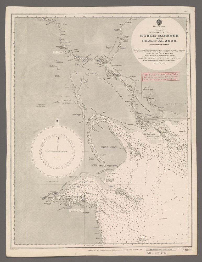
2. 'Sketch of Approaches to Kuweit Harbour and Shatt Al Arab'
- Description:
- Abstract: Chart F3293.Hydrographic chart of the Shatt al Arab in southern Mesopotamia from the vicinity of Al Basra [Al Basrah, Iraq] approximately 100 miles south-eastwards to its mouth at the head of the Persian Gulf. Also includes the approaches to Kuweit [Kuwait] Harbour. Portrays hydrology, including depths by soundings and contours, sands, rocks and mud, relief by spot heights and shading, vegetation, cultivation, canals, settlements including significant buildings, forts and tombs, and place names, and includes topographical notes and navigational aids, including buoys, lights and prominent buildings.Compiled 'from various authorities'. Engraved by Davies & Company. Published by the Admiralty and 'issued for Fleet purposes' 1902, with new editions 1904, 1907, 1909 and 1912, and small corrections.The sheet bears the stamps:'For Fleet Purposes Only. Care is to be taken that this chart is not allowed to get into the hands of unauthorised persons' in red on the map face.The number '170.12' in black in the upper right margin.Physical description: Materials: Printed on paperDimensions: 597 x 456mm, on sheet 660 x 507mm
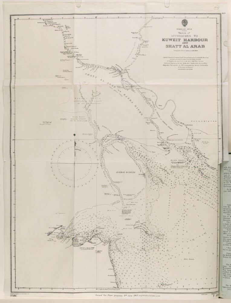
3. 'Sketch of Approaches to Kuweit Harbour and Shatt Al Arab, compiled from various authorities'
- Description:
- Abstract: A map originally issued for Fleet purposes, 2 June 1902. Large corrections made December 1904, and July 1907. Small corrections made December 1906, July 1908, and September 1908.The map shows lights, gravel, mud, rock, sand, shells and stones.Physical description: Materials: printed on paper.Dimensions: 610 x 470mm, on a sheet 655 x 480mm.
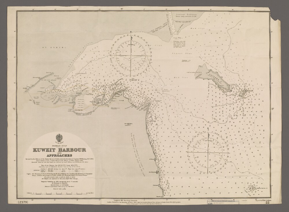
4. 'Kuweit Harbour and Approaches'
- Description:
- Abstract: Chart 22. (The chart also bears the number '2379'.)Hydrographic chart covering the central and northern coast of Kuweit [Kuwait], including Kuweit Harbour, and the north-western part of the head of the Persian Gulf. Portrays hydrology, including depths by soundings and contours, sands, mud and rocks, relief by form lines and spot heights, vegetation, settlements, forts and place names, and includes topographical notes and navigational aids, including buoys, beacons and prominent buildings.Chart surveyed under the direction of Captain Thomas Henry Heming, Royal Navy, 1905; also lieutenants John Michael Guy, Indian Navy, and George Barnes Brucks, Indian Navy, 1825. Engraved by Weller & Addison. Published at the Admiralty, 1907.Physical description: Materials: Printed on paperDimensions: 468 x 632mm, on sheet 494 x 684mmTop right corner of margin not present on transfer