Abstract: This volume is
A Handbook of Mesopotamia, Volume III, Central Mesopotamia with Sourthern Kurdistan and the Syrian Desert(Admiralty War Staff Intelligence Division, January, 1917), covering the Tigris and Euphrates from Baghdad and Fellūjeh [Fallujah] to Mosul and Meskeneh [Maskanah], the Lesser Zāb, the country east of the Tigris towards the Persian frontier, and the routes running westward from the Euphrates valley across the Syrian Desert. The volume was prepared on behalf of the Admiralty and War Office, and appears to be based on official and unofficial publications and maps which are cited in a bibliographical section in the volume. This volume was supplemented with corrections and additions in June 1918 (see IOR/L/MIL/17/15/41/5).The volume includes a note on confidentiality, a title page, 'Note', 'Abbreviations'. There is a page of 'Contents' which includes the following sections:Introduction;River Routes (The Tigris and the Lesser Zāb, The Euphrates);Land Routes (The Tigris Valley with Region to East, The Euphrates Valley, Connexions between Tigris and Euphrates Valleys, The Syrian Desert);Gazetteer of Towns;Bibliographical Note;Transliteration of Names;Glossary;Appendix;Index;'Sketch Map of Routes', which includes 'City Map of Baghdad' (f. 212) and 'Mesopotamia: Outline Map Showing Routes, Volume III' contained in a pocket.Physical description: Foliation: The foliation sequence commences at the inside front cover and terminates at the inside back cover; these numbers are written in pencil, are circled, and are located in the top right corner of the recto side of each folio (except for the front cover, where the folio number is located on the verso).Pagination: The volume also has an original printed pagination sequence.
Abstract: This volume is
A Handbook of Mesopotamia, Volume IV, Northern Mesopotamia and Central Kurdistan(Admiralty War Staff Intelligence Division, April, 1917), covering Mesopotamia north of the line joining Rowanduz, Mosul, Meskeneh [Maskanah], and Aleppo, up to Van, Bitlis, Diarbekr, and Mar‘ash. The volume was prepared on behalf of the Admiralty and War Office, and appears to be based on official and unofficial publications and maps which are cited in a bibliographical section in the volume.The volume includes a note on confidentiality, a title page, 'Note', and 'Abbreviations'. There is a page of contents which includes the following sections:Introduction;Itineraries;River Routes (The Tigris, The Euphrates);Land Routes (Central Kurdistan, Routes between Mosul and Diarbekr, Routes between the Plain of Diarbekr and the Moutains to North and West, Routes between the line Diarbekr-Mardīn and the Euphrates, Interior of Norther Jezīreh, West of the Jaghjagha Su, The Euphrates Valley and Country West thereof, Across the Taurus between the Euphrates and Mar‘ash, and Aleppo-Mar‘ash);Railways (Aleppo-Ras el-‘Ain-Tel Ermen);Gazetteer of Towns;Bibliographical Note;Transliteration of Names;Glossary;Index;Plates;'Sketch Map of Routes'.The volume contains 15 plates, which illustrate the content of the various chapters, and 1 map entitled 'Mesopotamia: Outline Map Showing Routes'.Physical description: Foliation: The foliation sequence commences at the inside front cover and terminates at the inside back cover; these numbers are written in pencil, are circled, and are located in the top right corner of the recto side of each folio (except for the front cover, where the folio number is located on the verso).Pagination: The volume also has an original printed pagination sequence.
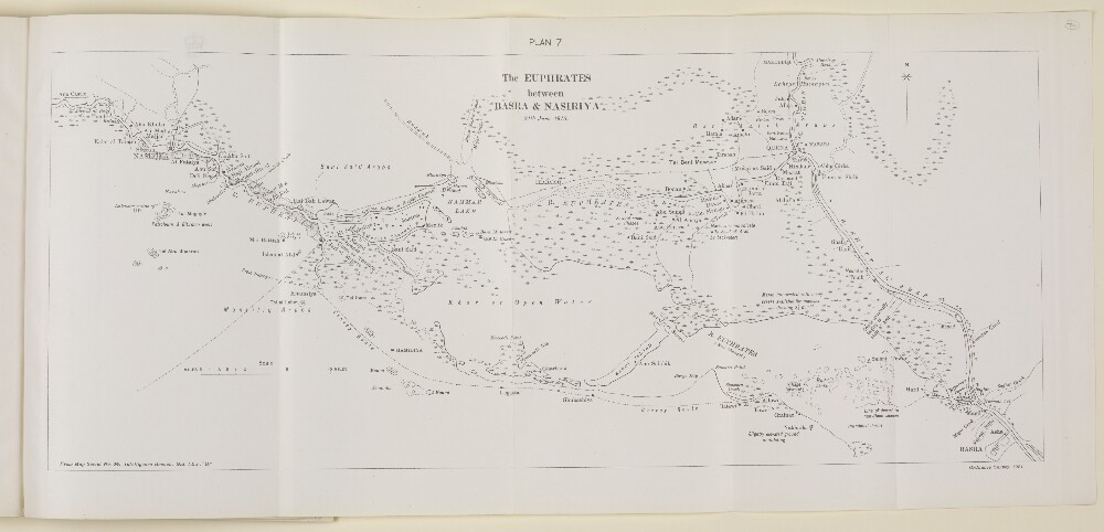
Abstract: Imprint:Ordnance Survey, 1921.Compiled from map produced by the Intelligence Branch G.S. I.E.F. “D” serial no. 34.Distinctive Features:Relief shown by contours.General map of the Euphrates River between Basra and Nasiriya [Nasiriyah] showing various channels with marshes depicted in detail.Convoy route from Nasiriya to Allowi [Alawi] indicated by pecked line.Physical description: Dimensions:201 x 488 mm, on sheet 245 x 533 mm
Abstract: The volume contains a chronological list of brief summaries of papers relating to the activities of the Indian Expeditionary Force D (also known as the Mesopotamia Expeditionary Force) between 1 and 31 March 1915. This is accompanied by appendices containing copies and extracts of these papers, which include letters, tables, and telegrams containing reports and orders.A summary of the contents of this volume can be found at folio 6, and the volume concerns:Intelligence summaries and appreciations [reports] from the Directorate of Military OperationsThe distribution and effective strength of Force DThe gathering and transport of reinforcements for Force DRequests for supplies and equipmentBritish efforts to gain the support of local Arab and Bakhtiari [Bakhtiyārī] rulersThe blockade of the EuphratesThe reorganisation of Force D as an Army Corps under the command of General Sir John Eccles NixonPossible terms of peace with Turkey [Ottoman Empire]The distribution of the Turkish ArmySuspicions regarding German activity, and particularly that of Wilhelm Wassmuss, in south Persia [Iran].Summaries of the contents of previous volumes can be found at folios 3 to 5.The volume contains a small number of copies of telegrams and letters from February 1915.Physical description: Foliation: the foliation sequence commences at the front cover with 1 and terminates at the inside back cover with 236; these numbers are written in pencil, are circled, and are located in the top right corner of the recto side of each folio. An additional foliation sequence is also present in parallel between ff 7-234; these numbers are printed and are located in the bottom centre of the recto side of each folio.Dimensions: 21x33cm
Abstract: Memorandum, written by Richard William Brant and Edward Parkes of the Foreign Office, Apr 1913 regarding navigation on the Tigris and Euphrates rivers. The memorandum is divided into four parts:Historical Memorandum respecting the navigation of the Mesopotamian rivers. The memorandum describes the history of British relations with Turkish Arabia and the progress of their relations in order to determine the rights that Great Britain possesses which allow it to participate in the trade and navigation of the Tigris and Euphrates rivers. The memorandum covers both the period where rights were acquired by the East India Company (1579-1859) and from 1860s onwards where rights and special privileges were acquired and maintained on behalf of the Tigris and Euphrates Steam Navigation Company (folios 8-66);British rights by treaty with regard to the navigation of the Tigris and Euphrates, which looks at the rights accrued by Great Britain through treaties with the Ottoman Government and through the Ottoman Empire's treaties with other nations (folios 67-70);Conclusions, which summarises the conclusions that can be drawn from the information provided in both the historical memorandum and the treaties sections (folios 71-74);Chronological Table covering the period 1759 to 1912, with annual entries from 1873 onwards (folios 75-119) ;Annex: Instances where the employment of British steamers in the navigation of the Tigris and Euphrates has been asserted or admitted to be limited by the Firmans of 1834 and 1841;Appendices: 34 items which are listed on folio 122, and include extracts and copies of Treaties, Firmans, Memorandum, Circulars and other relevant documents covering the period 1718 to 1912.Physical description: Foliation: The main foliation sequence commences at the inside front cover, and terminates at the inside back cover; these numbers are written in pencil, are circled, and are located in the top right corner of the recto side of each folio (except for the front cover where the folio number is on the verso). An additional foliation sequence is also present in parallel between folios 4-139; these numbers are also written in pencil, but are not circled, and can be found in the same position as the main sequence.Pagination: The volume also contains an original printed pagination sequence.
Abstract: This file is a Foreign Office memorandum regarding the right of the Euphrates and Tigris Steam-ship Company to sail their barges on those rivers, written by Foreign Office Librarian, Edward Hertslet.The file contains a summary of negotiations between the British and Ottoman Governments and as such, also contains extracts from Ottoman Government documents in French.Physical description: Foliation: The foliation for this description commences at f 97, and terminates at f 104, as it is part of a larger physical volume; these numbers are written in pencil, are circled, and are located in the top right corner of the recto side of each folio. An additional foliation sequence is also present in parallel; these numbers are also written in pencil, but are not circled, and can be found in the same position as the main sequence.
Abstract: This file is a Foreign Office memorandum regarding the rights of British Ships of War to sail on the Tigris and Euphrates rivers written by Foreign Office Librarian, Edward Hertslet.The file contains a simplified map of the Tigris, the Euphrates, the Shatt el-Arab [Shatt al-Arab] and the northern part of the Persian Gulf on folio 93r.Physical description: Foliation: The foliation for this description commences at f 93, and terminates at f 96, as it is part of a larger physical volume; these numbers are written in pencil, are circled, and are located in the top right corner of the recto side of each folio. An additional foliation sequence is also present in parallel; these numbers are also written in pencil, but are not circled, and can be found in the same position as the main sequence.
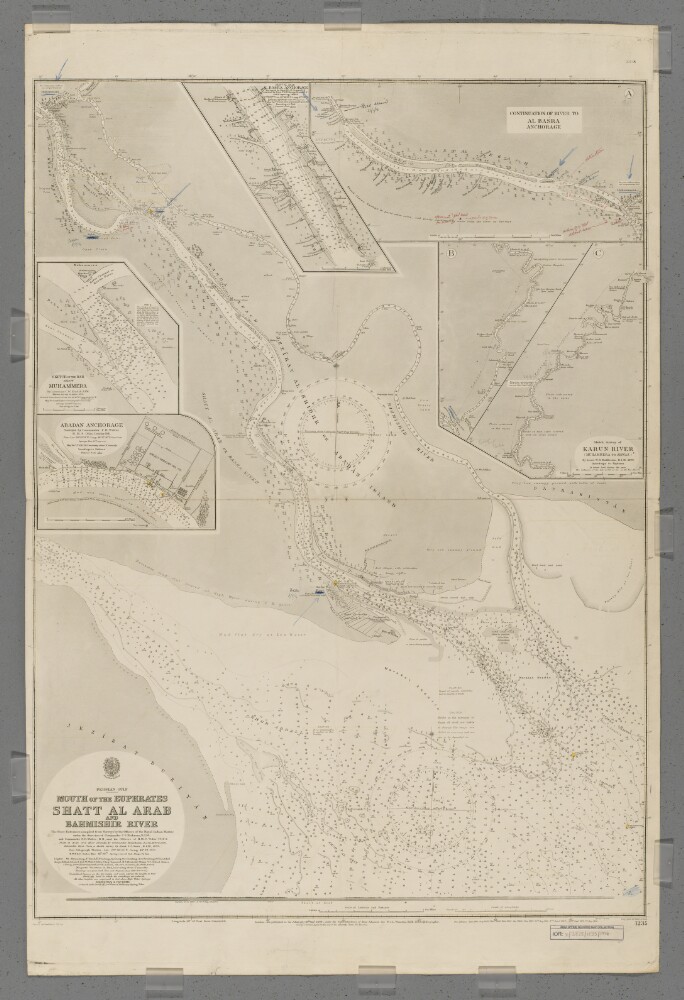
Abstract: Chart 1235 (June 1914 Edition with manuscript additions)Hydrographic chart of southern Mesopotamia covering the lower Shatt al Arab (the combined mouth of the Euphrates and Tigris rivers), the Bahmishir River [Rudkhaneh-ye Bahmanshir] (a secondary estuary of the Karun River [Rudkhaneh-ye Karun]) and the head of the Persian Gulf. Portrays hydrology, including depths by soundings and contours, sands and mud, vegetation, cultivation, railways, telegraph lines, settlements including significant buildings, and place names, and includes topographical notes and navigational aids, including buoys, lights and prominent buildings. Also shows an annotated sketch view, at an unspecified scale, of the mouth of the Shatt al Arab taken from the south.Includes insets of a northwards continuation of the Shatt al Arab to Al Basra [Al Basrah, Iraq] Anchorage, at scale approximately 1:95,000; the Karun River from Ahwaz, [Ahvaz, Iran] to its confluence with the Shatt al Arab at scale approximately 1:300,000; Adaban Anchorage at scale approximately 1:22,000; Muhammera [Khorramshahr, Iran] at scale approximately 1:17,000; and Al Basra Anchorage at scale approximately 1:15,000.Manuscript additions in coloured ink and crayon show military movements to November 1914.The river entrances surveyed by lieutenants Walford Charles Taylor, Edmund Wilmot Danson and Edward Heath Dauglish, Royal Indian Marine, under the direction of Commander Charles Steward Hickman, Royal Indian Marine, and Commander Frederic Henry Walter, Royal Navy, and the officers of Her Majesty's Ship
Odin, 1911. Shatt al Arab and Khor Abdalla created by Commander Willoughby George Beauchamp, Royal Indian Marine, 1899 and 1906. Bahmishir River from a sketch survey by Lieutenant Gordon S Gunn, Royal Indian Marine, 1890. Engraved by Malby & Sons. Published at the Admiralty 1898, with new editions 1899, August 1900, November 1900, 1902, 1904, 1907, 1911, January 1912, September 1912, May 1914, and small corrections June 1914.The sheet bears the stamp '304.14' in the upper right margin.Physical description: Materials: Printed, with manuscript additions in watercolour, coloured ink and crayon, on paperDimensions: 914 x 676mm, on sheet 1032 x 688mm
Abstract: This file contains a selection of correspondence related to the right of British Merchant-Vessels to use the Tigris and Euphrates rivers. This correspondence is primarily between British officials but also includes copies of letters between Ottoman officials including one letter in French (ff 110r-111).Physical description: Foliation: The foliation for this description commences at f 107, and terminates at f 112, as it is part of a larger physical volume, these numbers are written in pencil, are circled, and are located in the top right corner of the recto side of each folio. An additional foliation sequence is also present in parallel between ff 5-128; these numbers are also written in pencil, but are not circled, and can be found in the same position as the main sequence.
Abstract: Copy of a memorandum regarding the unsuitability of iron steam vessels for use on the Euphrates and Indus rivers. (With a note in pencil, by unknown author, criticizing the tone of the memorandum and asking for another opinion).Physical description: 1 item (3 folios)
Abstract: This volume is
A Handbook of Mesopotamia, Corrections and Additions to Volume III: Central Mesopotamia with Southern Kurdistan and the Syrian Desert(Naval Staff Intelligence Department: June, 1918). It supplements Volume III (IOR/L/MIL/17/41/4) which includes routes along the middle Tigris and Euphrates from Baghdad to Fellūjeh [Fallujah] up to Mosul and Meskeneh [Maskanah]. The volume was prepared on behalf of the Admiralty and the War Office. These corrections and additions are based partly on information dating from before the Mesopotamian Campaign and partly on intelligence from 1917-1918.The volume contains a note on confidentiality, title page, 'Note', and 'Abbreviations'. There is a page of contents which includes 'Corrections and Additions to Itineraries' for River Routes and Land Routes, 'Corrections and Additions to Gazetteer of Towns', and 'Corrections and Additions to Appendix'. Several pages have been left blank for convenience of use with interleaved copies of the original edition.Physical description: Foliation: The foliation sequence commences at the inside front cover and terminates at the inside back cover; these numbers are written in pencil, are circled, and are located in the top right corner of the recto side of each folio (except for the front cover, where the folio number is located on the verso).Pagination: The volume also contains an original printed pagination sequence.
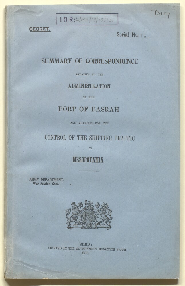
Abstract: This secret summary was compiled by the Army Department, War Section Case and printed in Simla in September 1919. It contains letters and telegrams sent from 11 December 1915 to 14 August 1916 between the officers of the Government of India and the Director-General of Port Administration and River Conservancy on the administration of the Port of Basrah [Basra].The summary also contains 'Report of Major-General G F MacMunn's Committee on the Organization of the River Service in Mesopotamia' (folios 58-66), with recommendations for the Royal India Marine Services, on the method of employing existing and forthcoming vessels, and measures for the control of the shipping traffic on the Tigris and Euphrates rivers.Physical description: The foliation sequence commences at the front cover, and terminates at the inside back cover; these numbers are written in pencil, are circled, and are located in the top right corner of the recto side of each folio. The volume also contains an original printed pagination sequence.