Number of results to display per page
Search Results
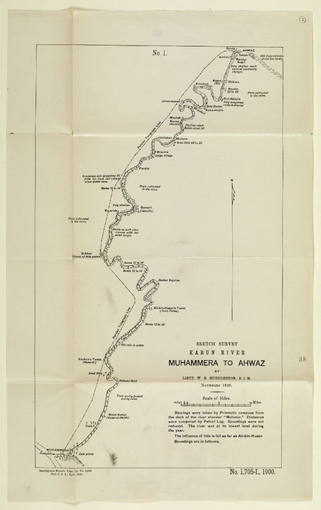
13. ‘Sketch Survey Karun River Muhammera to Ahwaz by Lieut. W. B. Huddleston, R.I.M. November 1899’
- Description:
- Abstract: Sketch map showing the course of the river Karun from Muhammera [Khorramshahr] to Ahwaz [Ahvāz], based on a survey undertaken by Lieutenant Willoughby Baynes Huddleston of the Royal Indian Marine in November 1899. The map indicates: the nature and course of the river; soundings, measured in fathoms; the height of banks, given in feet; plains; villages; and other features, such as tombs and mounds. A note below the title of the map states that bearings were taken with a prismatic compass from the deck of the river steamer Malamir, at a time of year when the river was at its lowest annual point.Other labels on the map: at the top, ‘No. 1’; at the bottom: ‘Exd C.J.A.’Physical description: Dimensions: 406 x 244 mm, on sheet 486 x 302 mm.Materials: Printed on paper.
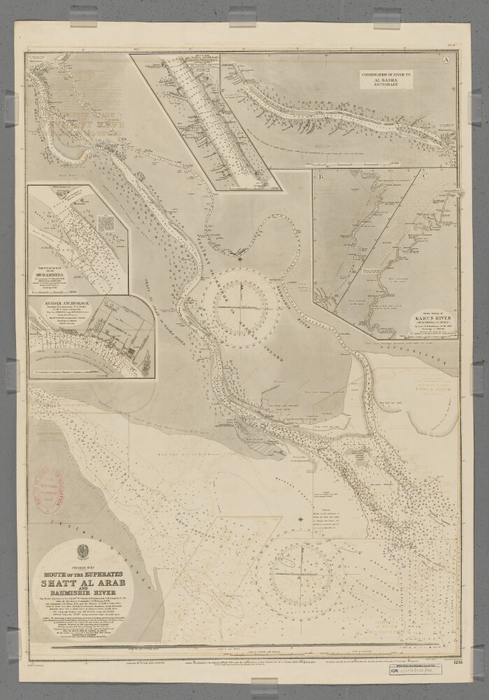
14. 'Mouth of the Euphrates, Shatt Al Arab and Bahmishir River'. September 1912 Edition
- Description:
- Abstract: Chart 1235 (September 1912 Edition)Hydrographic chart of southern Mesopotamia covering the lower Shatt al Arab (the combined mouth of the Euphrates and Tigris rivers), the Bahmishir River [Rudkhaneh-ye Bahmanshir] (a secondary estuary of the Karun River [Rudkhaneh-ye Karun]) and the head of the Persian Gulf. Portrays hydrology, including depths by soundings and contours, sands and mud, vegetation, cultivation, railways, telegraph lines, settlements including significant buildings, and place names, and includes topographical notes and navigational aids, including buoys, lights and prominent buildings. Also shows an annotated sketch view, at an unspecified scale, of the mouth of the Shatt al Arab taken from the south.Includes insets of a northwards continuation of the Shatt al Arab to Al Basra [Al Basrah, Iraq] Anchorage, at scale approximately 1:95,000; the Karun River from Ahwaz, [Ahvaz, Iran] to its confluence with the Shatt al Arab at scale approximately 1:300,000; Adaban Anchorage at scale approximately 1:22,000; Muhammera [Khorramshahr, Iran] at scale approximately 1:17,000; and Al Basra Anchorage at scale approximately 1:15,000.The river entrances surveyed by lieutenants Walford Charles Taylor, Edmund Wilmot Danson and Edward Heath Dauglish, Royal Indian Marine under the direction of Commander Charles Steward Hickman, Royal Indian Marine, and Commander Frederic Henry Walter, Royal Navy, and the officers of Her Majesty's Ship Odin, 1911. Shatt al Arab and Khor Abdalla created by Commander Willoughby George Beauchamp, Royal Indian Marine, 1899 and 1906. Bahmishir River from a sketch survey by Lieutenant Gordon S Gunn, Royal Indian Marine, 1890. Engraved by Malby & Sons. Published at the Admiralty 1898, with new editions 1899, August 1900, November 1900, 1902, 1904, 1907, 1911, January 1912, September 1912 and small corrections.The sheet bears the stamps:'Not to be used for navigation. For reference purposes only' in red on the map face.The number '279.12' in black in the upper right margin.Physical description: Materials: Printed on paperDimensions: 914 x 676mm, on sheet 996 x 689mm
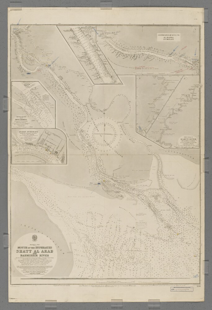
15. 'Mouth of the Euphrates, Shatt Al Arab and Bahmishir River'. June 1914 Edition with manuscript additions
- Description:
- Abstract: Chart 1235 (June 1914 Edition with manuscript additions)Hydrographic chart of southern Mesopotamia covering the lower Shatt al Arab (the combined mouth of the Euphrates and Tigris rivers), the Bahmishir River [Rudkhaneh-ye Bahmanshir] (a secondary estuary of the Karun River [Rudkhaneh-ye Karun]) and the head of the Persian Gulf. Portrays hydrology, including depths by soundings and contours, sands and mud, vegetation, cultivation, railways, telegraph lines, settlements including significant buildings, and place names, and includes topographical notes and navigational aids, including buoys, lights and prominent buildings. Also shows an annotated sketch view, at an unspecified scale, of the mouth of the Shatt al Arab taken from the south.Includes insets of a northwards continuation of the Shatt al Arab to Al Basra [Al Basrah, Iraq] Anchorage, at scale approximately 1:95,000; the Karun River from Ahwaz, [Ahvaz, Iran] to its confluence with the Shatt al Arab at scale approximately 1:300,000; Adaban Anchorage at scale approximately 1:22,000; Muhammera [Khorramshahr, Iran] at scale approximately 1:17,000; and Al Basra Anchorage at scale approximately 1:15,000.Manuscript additions in coloured ink and crayon show military movements to November 1914.The river entrances surveyed by lieutenants Walford Charles Taylor, Edmund Wilmot Danson and Edward Heath Dauglish, Royal Indian Marine, under the direction of Commander Charles Steward Hickman, Royal Indian Marine, and Commander Frederic Henry Walter, Royal Navy, and the officers of Her Majesty's Ship Odin, 1911. Shatt al Arab and Khor Abdalla created by Commander Willoughby George Beauchamp, Royal Indian Marine, 1899 and 1906. Bahmishir River from a sketch survey by Lieutenant Gordon S Gunn, Royal Indian Marine, 1890. Engraved by Malby & Sons. Published at the Admiralty 1898, with new editions 1899, August 1900, November 1900, 1902, 1904, 1907, 1911, January 1912, September 1912, May 1914, and small corrections June 1914.The sheet bears the stamp '304.14' in the upper right margin.Physical description: Materials: Printed, with manuscript additions in watercolour, coloured ink and crayon, on paperDimensions: 914 x 676mm, on sheet 1032 x 688mm

16. 'Notes on Tours in Persia in 1881: the natural obstruction to the Navigation to the Karoon River at Ahwaz as seen 1st December 1881'
- Description:
- Abstract: The memorandum consists of notes and observations on the navigability of the Karoon [Kārūn] river supplied by Captain H Wells, Royal Engineers, with a particular focus on Ahwaz [Ahvāz]. It also supplies a few suggestions for possible improvements.Physical description: Foliation: the foliation sequence commences at f 133, and terminates at f 134, as it is part of a larger physical volume; these numbers are written in pencil, and are located in the top right corner of the recto side of each folio. Pagination: the item also contains an original pagination sequence.
17. 'Précis of the Affairs of the Persian Coast and Islands, 1854-1905 By J A Saldanha, BA LL B'
- Description:
- Abstract: This volume is a collection of correspondence about the Persian Coast, selected by Jerome A Saldanha and printed in Simla in 1906.The volume is divided into twelve chapters:Internal Affairs, with list of officials and events (folios 7-16);Claims of the Imam of Maskat [Muscat] to the islands of Kishm, Angaum and Ormuz and the town of Bandar Abbas and its dependencies (folios 17-30);Anglo-Persian War of 1856-57. British Expedition to the Persian Gulf and Karun River (folios 31-34);Various attempts made to establish Persian influence in the Persian Gulf, 1887-1905 (folios 35-39);Residency appointments, establishments, and guards and buildings on the Persian Coast and Islands (folios 40-49);British extra-territorial jurisdiction on the Persian Coast and Islands (folios 50-62);Questions of Status (folios 63-69);Claims of British subjects and protegés against the Persian Government and Officials and Persian subjects (folios 70-80);Certain miscellaneous affairs with regard to British relations with Persia (folios 81-87);Infringement of British Commercial Rights (folios 88-94);Introduction of Belgian Customs Administration and new Tariff, 1900-1905 (folios 95-100);Persian interference with the British Postal arrangements (folios 101-103).Physical description: Foliation: the sequence commences at the front cover, and terminates at the inside back cover; these numbers are written in pencil, are circled, and are located in the top right corner of the recto side of each folio. The volume also contains an original printed pagination sequence.
18. 'Karun River: Memorandum by Mr Baring'
- Description:
- Abstract: The memorandum is a response from Walter Baring to Sir Henry Creswicke Rawlinson's argument that the potential benefits of opening up the Karun [Kārūn] River to steam navigation are outweighed by the potential problems (see IOR/L/PS/18/C35). It argues that the Karun River scheme should not be completely abandoned, and that the transhipment of goods could bypass the natural obstruction to steam vessels at Ahwaz [Ahvāz]. It also includes some discussion of some of the overland routes into Persia.Physical description: Foliation: the foliation sequence commences at f 136 and terminates at f 137, as it is part of a larger physical volume; these numbers are written in pencil, and are located in the top right corner of the recto side of each folio. Pagination: the item also contains an original pagination sequence.
19. 'Karun River: Note by Sir O St John'
- Description:
- Abstract: The memorandum — written by Sir Oliver Beauchamp Coventry St John — offers a differing opinion to that offered by Sir Henry Creswicke Rawlinson (see IOR/L/PS/18/C35) and Walter Baring (see IOR/L/PS/18/C36) on the Karun [Kārūn] River project. It argues that both have overestimated the difficultly in overcoming the natural obstruction at Ahwaz [Ahvāz], which would open the upper river to light steamers. It also argues against funding the construction of carriage roads in Persia in favour of light railways and mule roads.Included in the memorandum are two tables showing the height of various ascents along both the Shuster [Shūshtar]-Isfahan [Eşfahān] and the Bushire-Shiraz routes.Physical description: Foliation: the foliation sequence commences at f 138 and terminates at f 139, as it is part of a larger physical volume; these numbers are written in pencil, and are located in the top right corner of the recto side of each folio. Pagination: the item also contains an original pagination sequence.
20. 'Karun River: Memorandum by Sir H Rawlinson'
- Description:
- Abstract: The memorandum outlines Sir Henry Creswicke Rawlinson's opinion that the importance of opening up the Karun [Kārūn] River to steam navigation has been vastly overstated; the difficulties outweigh the potential benefits. It also includes some discussion of the overland routes into Persia.Physical description: Foliation: the foliation sequence commences and terminates at f 135, as it is part of a larger physical volume; these numbers are written in pencil, and are located in the top right corner of the recto side of each folio. Pagination: the item also contains an original pagination sequence.
21. Foreign Office Papers: Persia
- Description:
- Abstract: This item comprises printed Foreign Office correspondence relating to Persia [Iran], covering geopolitical, political, economic, social and cultural matters. The despatches are dated 18 December 1891-30 June 1897.The first page of each despatch includes the heading ‘ASIA. CONFIDENTIAL.’ on the top left, and the day and month of the despatch in square brackets on the top right e.g. ‘[December 18.]’. The letters in each despatch are numbered, e.g. No. 1, followed, where relevant, by numbered enclosures (spelled ‘inclosure’ in the volume), e.g. ‘Inclosure in No. 1.’ or ‘Inclosure 1 in No. 2.’.The item notably covers and includes:‘Correspondence respecting the Persian Tobacco Concession’, papers presented to the Houses of Parliament, June 1892 (Her Majesty’s Stationary Office). These papers (ff 37-88) cover: the opposition and hostility of people in Persia, notably merchants and clerics in Tehran, towards the tobacco concession (‘Régie’, or monopoly) granted in 1890 by the Shah [Shāh] of Persia to the United Kingdom, which gave the Imperial Tobacco Corporation control over the growth, sale and export of tobacco; the protests against it; and its cancellation in 1892. There is additional 1892 correspondence on the tobacco concession in the rest of the item. A number of letters and documents on the concession are in French‘Memorandum by Sir M. Durand, on the Situation in Persia’, December 1895, relating to the state of the Government in Persia, followed by a summary by George Nathaniel Curzon, 12 April 1896, deprecating the ‘deplorable’ conditions in the country (ff 89-112)A memorandum by Captain Percy Molesworth Sykes, HM Consul in Kerman, relating to the navigation and opening up to trade and commerce of the Karun River and valley, with appendices (Appendix II is in French) (ff 121-130)Russia’s despatch of Russian Cossack soldiers to the Perso-Afghan frontier ostensibly to prevent the spread of plague from India into Russia via Afghanistan, including a collision between Russians and Afghans at the Perso-Afghan frontier and Russian concern about quarantine arrangements by the British Medical Officer in Seistan [Sistan]Russo-Persian relationsPerso-Afghan relationsPublic construction worksCivil disturbances in PersiaThe state of the Government in TehranRussian railway projects on the South Caspian littoralConstruction of a caravan route between Ahwaz [Ahvaz] and Ispahan [Isfahan], generally known as the ‘Bakhtiari road’ [in connection with the Bakhtiyārī people whose territory the route ran through], and the involvement of Messrs Lynch Brothers in the project. Included on folio 156 is a ‘Route map of the Tracks between Ahwaz, Shushter [Shushtar] & Ispahan’ (Mss Eur F111/69A, f 156)The import trade in arms at Bushire [Bushehr]The funeral of Shah Nasr-ed-Din [Nāṣir al-Dīn]Anti-Semitic riots in the Jewish quarter of Tehran and British concern to protect British subjects of Jewish birth residing there.The primary correspondents are: the Marquess of Salisbury [also spelled ‘Marquis’ in this item], Prime Minister and Foreign Secretary; Sir Frank Cavendish Lascelles, British Ambassador to Persia; Sir Henry Mortimer Durand, Minister Plenipotentiary at Tehran; Charles Hardinge, First Secretary, Tehran; Sir Robert Burnett David Morier, Ambassador Extraordinary and Minister Plenipotentiary at St Petersburg (1884-93); the India Office; and the Foreign Office. Enclosures are chiefly from British diplomatic officials in Persia, notably John Richard Preece, HM Consul General at Ispahan, and Lieutenant-Colonel Henry Philip Picot, Military Attaché, Tehran, and occasionally from Persian Government officials.Physical description: 1 volume (207 folios)
22. The Anglo-Persian War
- Description:
- Abstract: This item comprises enclosures to a despatch from the Government of Bombay [Mumbai] Secret Department to the Secret Committee [Bombay Secret Letter], No. 24 dated 2 February 1857. The enclosures are dated 4-14 January 1857.The item comprises two despatches from Major-General Foster Stalker, Commanding the Persian Expeditionary Force, to the Secretary to the Government and the Quarter-Master General of the Army, Bombay, reporting the progress of operations against Persia [Iran], the condition of the troops, and logistical aspects of potential future movements of the Field Force, in particular the potential routes towards Shuster [Shushtar].The numerous enclosures to Stalker’s despatches consist of correspondence of, and reports by, the following military and naval officers and political officials: Lieutenant J [C?] Ballard, Superintendent Intelligence Department; Major R L Taylor, on Special Duty in Persia and Vice-Consul, Busrah [Basra]; Lieutenant J H Selby, Indian Navy, Commanding the Cometand Surveyor in Mesopotamia [Iraq]; Lieutenant Herbert Disbrowe, Assistant Political Agent, Persian Expeditionary Force; Captain J B Dunsterville, Assistant Commissary General, Persian Expeditionary Force; Major John Hill, Commanding Engineer, Persian Field Force; Lieutenant Claude Merriman, Field Engineer, Persian Field Force; Commander James Felix Jones, Indian Navy, Political Agent with the Forces, Civil Commissioner of the Town and Resident, Persian Gulf; Commodore Richard Ethersey, Commanding the Indian Naval Squadron in the Persian Gulf; and J G Taylor, HM Vice-Consul and Commissariat Agent, Busrah.The papers notably cover and include:A ‘Memorandum regarding the force of the enemy in Fars’, detailing the number and condition of Persian forces encamped at the village of Borazgaon [Borazjan] ‘36 miles from Bushire’ [Bushehr], and the names of the Persian commanding officers (ff 369-370)Strategic information regarding both the Karun River [also spelled Karoon in this item] and Bebehan [Behbahan] routes for a potential advance towards Shuster, including information on the geography, terrain and climate of the area around the Karun River as well as its navigability for large vessels and steamers, disembarkation points, and resources for supporting the armyInformation on Mohumrah [Khorramshahr, formerly Mohammerah] and the surrounding area including: the terrain, climate and agriculture; a list of ‘Arab tribes tributary to the Persians’ on that coastal region including the extent of their armaments (ff 373-376); a report by Lieutenant Merriman on his reconnoitre of the town and fortifications at Mohummerah and a sketch of the nature of the defences being erected by ‘the enemy’ there (IOR/L/PS/5/490, f 410)A report by Lieutenant Ballard ‘regarding the countries through which a force marching on Shuster or Bebehan respectively would have to pass’ ( ff 382-392)A ‘Sketch showing supposed movements of the enemy of English Army seizing Mohumrah preparatory to ascending the Karun’, and a sketch map by Lieutenant Ballard, of the route between Bushire and Shiraz (IOR/L/PS/5/490, f 393 and f 394)An estimate by Major Hill ‘of the probable military force that will be required for an expedition to Shuster, on the Karoon River’ (ff 404-409)Information regarding the commissariat measures that would be required in order to advance on and besiege Shuster, including the method of advancing on Mohumrah and the large number of camels and mules it would be necessary to procureA memorandum by Commodore Ethersey detailing the kind of river transport it would be advisable to procure for an expedition to Shuster near the head of the Karoon RiverGeneral reports regarding the procurement of supplies and animals for the force near Bushire and the expected reinforcementsInformation supplied by Major Hill regarding the supply of materials for defences and for buildings to accommodate the troops during hot weather, notably what can be utilized from date treesA coloured map entitled ‘Sketch of the position of British Force at Bushire’ (IOR/L/PS/5/490, f 422).The item also includes the ‘Political diary of events connected with and, business transacted in the Bushire Residency in relation to the Persian Gulf Expeditionary Force’ covering 22 December 1856 to 4 January 1857, inclusive (ff 423-428).Physical description: 1 item (62 folios)
23. Euphrates expedition
- Description:
- Abstract: Volume containing correspondence related to the Euphrates expedition of 1835-36, a survey of the navigability of the Euphrates River as part of a possible overland route between the Persian Gulf and the Mediterranean. The correspondence covers: the overland journey from Sovedia [Samandağ] to Bir [Birecik]; the journey down the Euphrates to Bussora [Basra]; delays to the expedition caused by the obstructionism of various Ottoman officials, particularly Mehmet Ali, Pasha of Egypt, and his son Ibrahim Pasha; the sinking of the steamer Tigrisduring a storm, with the loss of 23 men; exploratory journeys along the Tigris and Karoon [Karun] rivers; and analysis of the results of the expedition.The primary correspondent is the commander of the expedition Colonel Francis Rawdon Chesney. Other correspondents include: Chesney’s second-in-command Lieutenant Henry Blosse Lynch and other officers of the expedition; the Board of Control; the Government of Bombay; the British Consul, Aleppo; the British Consul, Baghdad; and HM Ambassador to the Ottoman Empire.Lists of the expedition’s personnel in March and October 1836 are included on folios 130 and 414, respectively. A list of the men lost in the sinking of the Tigrisis on folio 227.A breakdown of the distances and fuel consumption for each leg of the journey down the Euphrates is provided on folio 240, and for the return journey along the Tigris to Baghdad on folios 416 and 418. The dimensions of the steamer Euphratesare on folio 415.Lists of the contents of the Euphratesat the end of the expedition, including valuations, is provided on folios 503-515. The final accounts of the expedition are on folio 525.The bulk of the correspondence dates from 1834-1838, the later dates cover a request for a picture and short biography of Colonel Chesney for an article in the Dublin University Magazine(folios 551-568).The volume includes a table of contents on folios 1-8. Separate contents pages appear on folios 340-341, covering folios 342-403, and on folio 500, covering folios 501-526.Physical description: Foliation: the foliation sequence (used for referencing) commences at the first folio with 1 and terminates at the last folio with 568; these numbers are written in pencil, are circled, and are located in the top right corner of the recto side of each folio.
24. Map of the border region between Iraq and Persia
- Description:
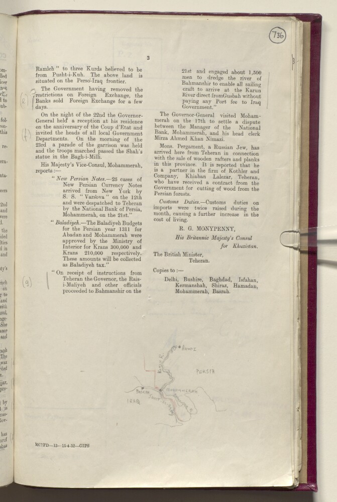
- Abstract: Pencil sketch showing the border region between Iraq and Persia [Iran]. The map indicates the Karun and Bahmanshir rivers, the coastline of the Persian Gulf and the Shatt al-Arab, and the towns of Ahwaz [Ahvāz], Mohammerah [Khorramshahr], and Basrah [Basra]. A red pencil line indicates the border between Iraq and Persia. The map refers to a portion of the report on the same folio, which mentions instructions issued by Persian Government officials to dredge the Bahmahshir ‘to enable all sailing craft to arrive at the Karun River direct from Gusbah [Qoşbeh-ye Manī‘āt] without paying any Port fee to Iraq Government’.Physical description: Dimensions: 60 x 80 mm.Materials: pencil on paper.
- « Previous
- Next »
- 1
- 2 Current Page, Page 2
- 3