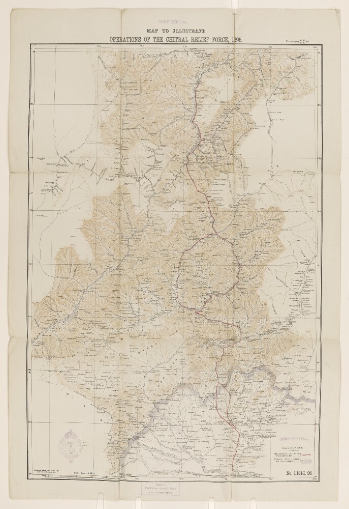
Abstract: Map showing the route of the Chitral Relief Force, with a red line in ink ascending from Kandar to Chitral. The map indicates hydrology, railways, and boundaries, and provides some indication of relief. Produced by the Intelligence Branch of the Government of India's Quarter Master General Department. Scale given as 1 inch = 4 miles.Physical description: Materials: Printed in colour on paper with annotations in ink.Dimensions: 902 x 606mm, on sheet 1017 x 813mm.
Abstract: Map showing Chitral state to the north of British India, in modern-day Pakistan. The map indicates hydrology and boundaries, as well as providing some indication of relief. Compiled and reproduced by the Intelligence Branch of the Government of India's Quarter Master General Department.Physical description: Materials: Printed in colour on paper.Dimensions: 579 x 824mm, on sheet 685 x 960mm.
Abstract: A compilation of correspondence, reports, memoranda, gazetteer extracts, dispatches and statistics, prepared by Trevor Chichele Plowden, the Officiating Under-Secretary to the Government of India Foreign Department. Printed in Calcutta, by the Foreign Department Press, 1878.The volume contains:'Chapter I. Correspondence relating to the establishment of a friendly understanding between England and Russia as to the general policy of the two Governments in Central Asia, with special reference to Afghanistan.''Chapter II. The Turkomans of the Attrek [Etrek], Akhal [Ahal], and Merv [Mary], and their relations with Russia, Persia, Afghanistan, and England.''Chapter III. Relations of the British Government with Biluchistan [Balochistān].''Chapter IV. Relations between the British Government, Cashmere [Kashmīr], and the Frontier States of Chitral [Chitrāl], Yassin [Yāsīn] and Dir [Dīr].''Chapter V. Events in Kashgar [Kāshgar] during 1875-1877. ''Chapter VI. Events in the Khanate of Kokand during 1875-1877.''Chapter VII. Events in the Khanate of Khiva during 1875-1877.''Chapter VIII. Events in the Khanate of Bokhara [Bukhara] during 1875-1877.''Chapter IX. Miscellaneous.'Appendices.The volume includes two fold-out maps: one stored in a pocket inside the front board; and one at folio 207.Physical description: Foliation: the foliation sequence for this description commences at the front cover with 1, and terminates at the inside back cover with 279; these numbers are written in pencil, are circled, and are located in the top right corner of the recto side of each folio. Pagination: the file also contains an original printed pagination sequence.
Abstract: Correspondence regarding the position of independent Indian States with regard to the 1926 'International Convention with the object of Securing the Abolition of Slavery and the Slave Trade', a copy of which is found on folios 27-32. The correspondence is between: Government of India, Foreign and Political Department; Government of India, External Affairs Department; The Secretary to the Crown Representative; the Political Officer in Sikkim; the General Secretary and Judicial Secretary to the Maharaja of Sikkim; the Agent to the Governor General in Baluchistan; and the Chief Secretary to the Government of the North-West Frontier Province.The papers discuss the application of the convention to some of the Indian 'Princely States' and cover the effort to ascertain their positions in this regard. The states involved are Sikkim, Kalat, Las Bela, and Chitral.Physical description: Foliation: the foliation sequence (used for referencing) commences at the front cover with 1, and terminates at the inside back cover with 33; these numbers are written in pencil, are circled, and are located in the top right corner of the recto side of each folio.