« Previous |
1 - 12 of 27
|
Next »
Number of results to display per page
Search Results
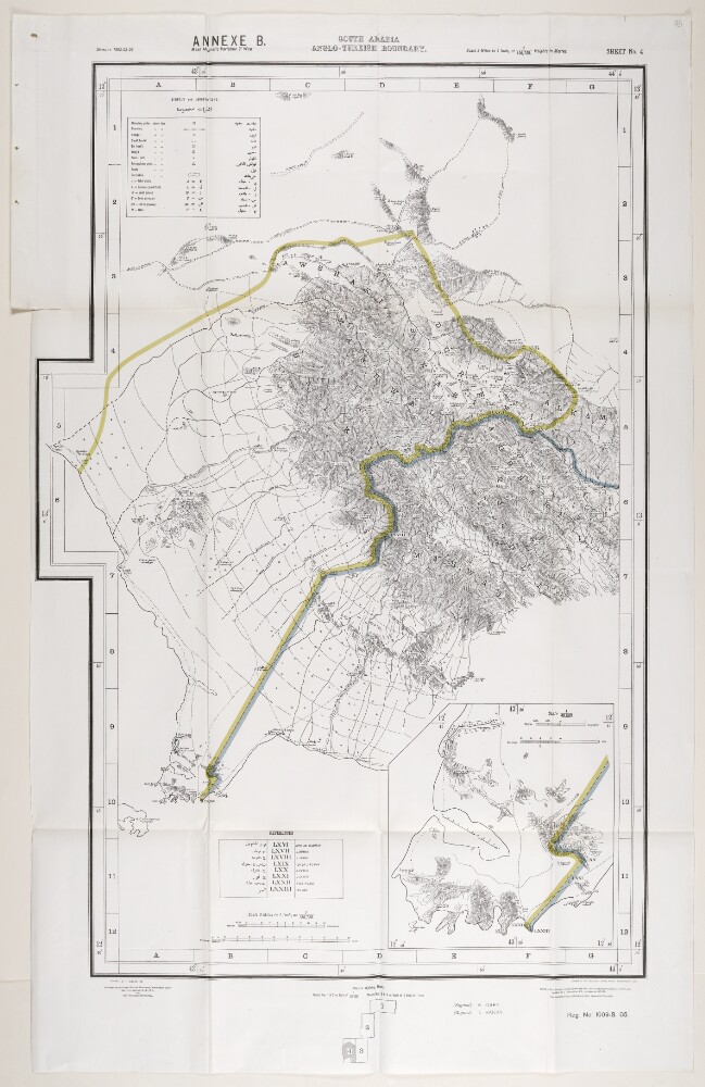
1. 'ANNEXE B. SOUTH ARABIA ANGLO-TURKISH BOUNDARY.'
- Description:
- Abstract: This map is enclosed in a printed copy of the Anglo-Ottoman Convention of 1914. It depicts the line of demarcation of the boundary determined to separate the Yemen from the territory of the nine cantons of Aden (shown in blue). Also included is an enlarged inset map of the Shekh Sa'id [Ra’s Shaykh Sa‘īd] peninsula.The map's borders are lettered and numbered. Areas on the map are marked with Roman numerals and listed in a table of references. Another table provides a key to symbols and abbreviations. Place names and symbol and abbreviation references are printed in English and Arabic. As well as boundaries the map indicates hydrology, settlements, cultivation and roads. Relief is shown by contours and spot heights.This map is sheet four of four. Also included is an index to adjoining sheets and a note on the survey's sources.Small printed text near below the map states that it was surveyed by the Anglo-Turkish Boundary Commission, under Colonel Robert Alexander Wahab and Colonel Mustapha Remzi Bey, and printed at the Ordnance Survey Office, Southampton, 1914. The map also states the names of the British and Ottoman signatories of the Anglo-Ottoman Convention: E Grey [Edward Grey, Secretary of State for Foreign Affairs] and I Hakky [Ibrahim Hakki Pasha, Ottoman representative].Physical description: Materials: Printed on paper.Dimensions: 935 x 621mm, on sheet 1081 x 689mm.
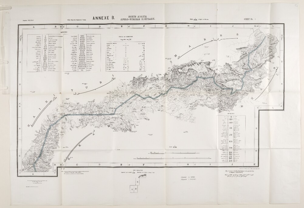
2. 'ANNEXE B. SOUTH ARABIA ANGLO-TURKISH BOUNDARY. SHEET NO. 1'
- Description:
- Abstract: This map is enclosed in a printed copy of the Anglo-Ottoman Convention of 1914. It depicts the line of demarcation of the boundary determined to separate the Yemen from the territory of the nine cantons of Aden (shown in blue).The map's borders are lettered and numbered and are used to reference places in an accompanying table. Areas on the map are marked with Roman numerals and are listed in a second table of references. A third table provides a key to symbols and abbreviations. Place names and symbol and abbreviation references are printed in English and Arabic. The map also indicates hydrology, settlements, cultivation and roads. Relief is shown by contours and spot heights.This map is sheet one of four. Also included is an index to adjoining sheets and a note on the survey's sources.Small printed text near below the map states that it was surveyed by the Anglo-Turkish Boundary Commission, under Colonel Robert Alexander Wahab and Colonel Mustapha Remzi Bey, and printed at the Ordnance Survey Office, Southampton, 1914. The map also states the names of the British and Ottoman signatories of the Anglo-Ottoman Convention: E Grey [Edward Grey, Secretary of State for Foreign Affairs] and I Hakky [Ibrahim Hakki Pasha, Ottoman representative].Physical description: Materials: Printed on paper.Dimensions: 485 x 865mm, on sheet 680 x 980mm.
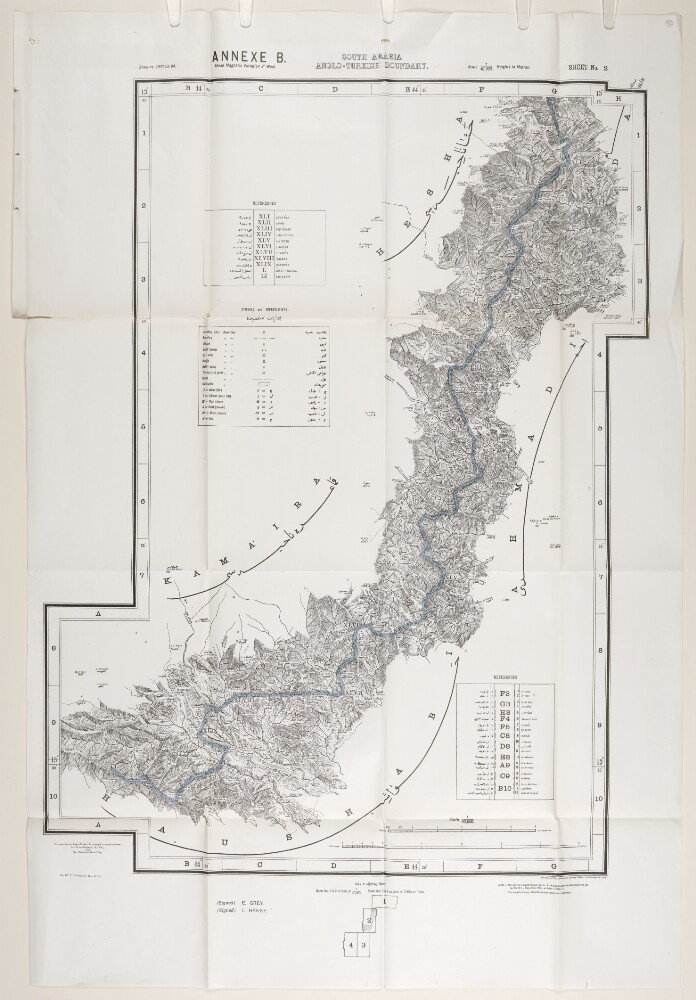
3. 'ANNEXE B. SOUTH ARABIA ANGLO-TURKISH BOUNDARY. SHEET NO. 2'
- Description:
- Abstract: This map is enclosed in a printed copy of the Anglo-Ottoman Convention of 1914. It depicts the line of demarcation of the boundary determined to separate the Yemen from the territory of the nine cantons of Aden (shown in blue).The map's borders are lettered and numbered and are used to reference places in an accompanying table. Areas on the map are marked with Roman numerals and are listed in a second table of references. A third table provides a key to symbols and abbreviations. Place names and symbol and abbreviation references are printed in English and Arabic. The map also indicates hydrology, settlements, cultivation and roads. Relief is shown by contours and spot heights.This map is sheet two of four. Also included is an index to adjoining sheets and a note on the survey's sources.Small printed text near below the map states that it was surveyed by the Anglo-Turkish Boundary Commission, under Colonel Robert Alexander Wahab and Colonel Mustapha Remzi Bey, and printed at the Ordnance Survey Office, Southampton, 1914. The map also states the names of the British and Ottoman signatories of the Anglo-Ottoman Convention: E Grey [Edward Grey, Secretary of State for Foreign Affairs] and I Hakky [Ibrahim Hakki Pasha, Ottoman representative].Physical description: Materials: Printed on paper.Dimensions: 803 x 554mm, on sheet 989 x 670mm.
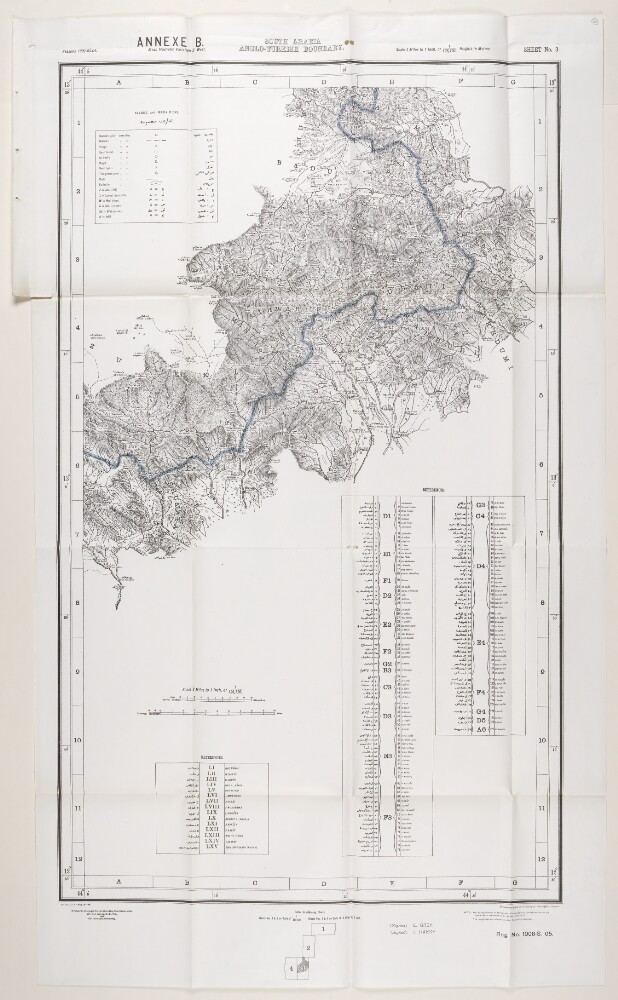
4. 'ANNEXE B. SOUTH ARABIA ANGLO-TURKISH BOUNDARY. SHEET NO. 3'
- Description:
- Abstract: This map is enclosed in a printed copy of the Anglo-Ottoman Convention of 1914. It depicts the line of demarcation of the boundary determined to separate the Yemen from the territory of the nine cantons of Aden (shown in blue).The map's borders are lettered and numbered and are used to reference places in an accompanying table. Areas on the map are marked with Roman numerals and are listed in a second table of references. A third table provides a key to symbols and abbreviations. Place names and symbol and abbreviation references are printed in English and Arabic. The map also indicates hydrology, settlements, cultivation and roads. Relief is shown by contours and spot heights.This map is sheet three of four. Also included is an index to adjoining sheets and a note on the survey's sources.Small printed text near below the map states that it was surveyed by the Anglo-Turkish Boundary Commission, under Colonel Robert Alexander Wahab and Colonel Mustapha Remzi Bey, and heliozincographed at the Survey of India Offices, Calcutta. The map also states the names of the British and Ottoman signatories of the Anglo-Ottoman Convention: E Grey [Edward Grey, Secretary of State for Foreign Affairs] and I Hakky [Ibrahim Hakki Pasha, Ottoman representative].Physical description: Materials: Printed on paper.Dimensions: 936 x 560mm, on sheet 1081 x 633mm.
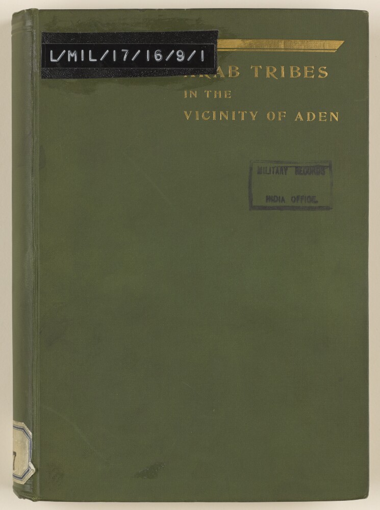
5. 'An Account of the Arab Tribes in the Vicinity of Aden'
- Description:
- Abstract: 'An Account of the Arab tribes in the Vicinity of Aden' that was originally compiled by Captain F M Hunter and C W H Sealy in 1886, added to intermittently by various officers of the Aden Residency and re-published and revised in September 1907 by Captain Arthur Henry Eyre Moose, Assistant Political Resident. The report is dated 1909 and was printed at the Government Central Press, Bombay.The account covers:the 'Abdalithe Subehithe 'Akrabithe Fadthlithe Haushabithe 'Aulakithe Yafaithe 'Alawithe 'Amir of Dthalathe Wahidithe Shaikh of 'Irkathe Shaikh of Lower HauraKishn and Sokotrathe Kasadithe Kaitithe Kathirihistorical resumé of Mokalla, Shehr and the HadthramutBehan al Kasabthe 'AudaliBeda.Appendix A is a detailed statement of tribes and chiefs in relations with the Aden Residency, Appendix B is a list of relevant treaties and engagements, Appendix C is a list of places visited from time to time by the Aden Troop, Appendix D is a number of genealogical tables and Appendix E is a list of notable personages in the Aden Protectorate.In a separate pouch, the file contains three maps as follows: Map of the Arabian Coast from Hiswa Mukaidthir to Makatin (folio 195), Map of the Arabian Coast from Makatin to Bandar Janjari (folio 196) and Map showing Tribes and New Boundary of the Aden Protectorate (folio 197).Physical description: Foliation: this file consists of two physical volumes. The foliation sequence commences at the inside front cover of volume one (ff 1-193) and terminates at the inside back cover of the second volume (ff 194-198); these numbers are written in pencil, are circled, and are located at the top right corner of the recto side of each folio. Pagination: volume one also contains an original printed pagination sequence.
6. 'Aden Boundary'
- Description:
- Abstract: The file consists of a memorandum on the Aden boundary delimitation prepared by Colin George Campbell for the India Office, with telegram excerpts from the Secretary of State for India, the Political Resident at Aden, and the Viceroy of India.It includes an update on developments with regard to Upper Yaffai and its inclusion in the nine tribes, and the question of military arrangements for the escort of the British Commission's surveying operations.Physical description: Foliation: the foliation sequence for this description commences at f 25, and terminates at f 27, as it is part of a larger physical volume; these numbers are written in pencil, and are located in the top right corner of the recto side of each folio. An additional foliation sequence is present in parallel between ff 30-32; these numbers are also written in pencil, but are circled.Pagination: the file also contains an original printed pagination sequence.
7. 'Aden Policy'
- Description:
- Abstract: The file consists of two notes by members of the Council of India, William Lee-Warner and Hugh Shakespear Barnes, on the Government of India's Letter No 119 dated 9 August 1906 (L/PS/10/74: Pol No 1455/06), concerning policy in Aden.William Lee-Warner's note opposes the Government of India's policy and discusses the following: the effect of the policy on troop numbers at Aden, increased political interference in the hinterland, and whether a garrison at D'thala [Aḑ Ḑāli‘] is needed, or the extension of railways desirable. A table is included providing sickness and mortality statistics among troops stationed at Aden, 1897-1904.Hugh Shakespear Barnes agrees with the Government of India's policy and states his views on the circumstances and effect of demarcation, the various methods of dealing with the tribes, railway extensions, and keeping a Political Officer and troops at D'thala.Physical description: Foliation: the foliation sequence for this description commences at f 184, and terminates at f 187, as it is part of a larger physical volume; these numbers are written in pencil, and are located in the top right corner of the recto side of each folio. An additional foliation sequence is present in parallel between ff 189-192; these numbers are also written in pencil, but are circled. Pagination: the file also contains an original printed pagination sequence.
8. 'Relations of the British Government with the Tribes of the Aden Hinterland'
- Description:
- Abstract: The file consists of a memorandum detailing the relations of the British Government with the tribes of the Aden hinterland by Richmond Thackeray Willoughby Ritchie, India Office, Secretary to the Political and Secret Department.It discusses the following: boundary lines, difficulties with the Turks which led to the delimitation, British responsibility resulting from the demarcation, relations with the Amir of Dthala [Aḑ Ḑāli‘] in particular, and protectorate agreements; it also gives a summary of troops stationed across the hinterland.It makes several references to 'the attached Memorandum' which is a separate file: IOR/L/PS/18/B156 'Memorandum respecting the Aden Frontier Delimitation'.Physical description: Foliation: the foliation sequence for this description commences at f 167, and terminates at f 169, as it is part of a larger physical volume; these numbers are written in pencil, and are located in the top right corner of the recto side of each folio. An additional foliation sequence is present in parallel between ff 172-174; these numbers are also written in pencil, but are circled.Pagination: the file also contains an original printed pagination sequence.
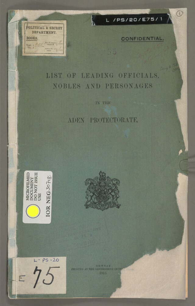
9. 'LIST OF LEADING OFFICIALS, NOBLES AND PERSONAGES IN THE ADEN PROTECTORATE.'
- Description:
- Abstract: An official publication entitled ‘List of Leading Officials, Nobles and Personages in the Aden Protectorate’. A stamp on the front cover indicates that this copy of the publication was enclosed in letter no. 33M from the Foreign Secretary of the Government of India to the Secretary of State for India dated 24 December 1915, and was received at the India Office on 31 January 1916.The publication is divided into seventeen chapters, each covering a tribe or polity of the Aden Protectorate. Each chapter contains historical notes on the tribe or polity and biographical details of local rulers and other leading personalities. The chapter on the Abdali State [Sultanate of Lahej] also contains a genealogical table.The publication was printed at the Government Central Press in Bombay [Mumbai] in 1915.Physical description: Foliation: the foliation sequence (used for referencing) commences at the front cover with 1, and terminates at the inside back cover with 14; these numbers are written in pencil, are circled, and are located in the top right corner of the recto side of each folio.Pagination: an original printed pagination sequence is also present.
10. 'ADEN PROTECTORATE'
- Description:
- Abstract: Map of the south-eastern part of the Arabian Peninsula, showing the boundaries of the Aden Protectorate and various proposed lines for the boundaries of south-eastern Arabia and Qatar. In addition to boundaries the map indicates hydrology and tribal areas, and provides some indication of relief. A key of reference indicates some of the boundaries and features. A note in the bottom right-hand corner states that the map was drawn by Sapper R Bunyan. The scale is given as 1 inch to 32 miles.Physical description: Materials: Manuscript on paper.Dimensions: 828 x 1016mm, on sheet 850 x 1040mm.
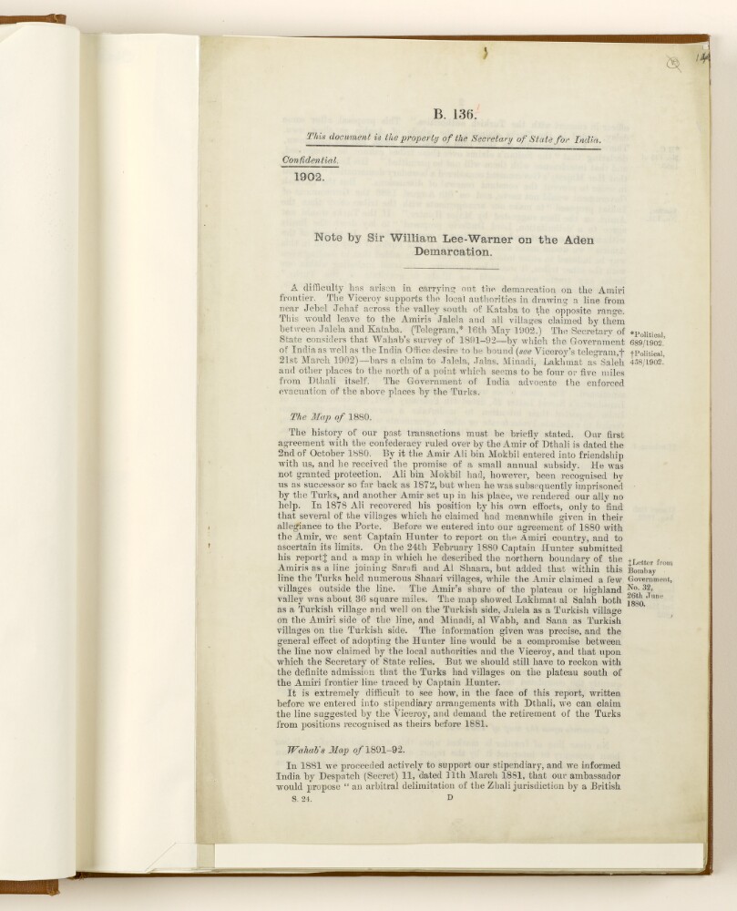
11. 'Note by Sir William Lee-Warner on the Aden Demarcation'
- Description:
- Abstract: The file consists of a note concerning the Aden demarcation by William Lee-Warner, India Office, Secretary to the Political and Secret Department.It discusses the following: the difficulties which have arisen in carrying out the demarcation on the Amiri frontier, the history of past agreements concerning Captain Hunter's map of 1880, the survey of Captain R A Wahab of 1891-92 with comments, the Demarcation Commission, and proposals for the future.Physical description: Foliation: the foliation sequence for this description commences at f 14, and terminates at f 15, as it is part of a larger physical volume; these numbers are written in pencil, and are located in the top right corner of the recto side of each folio. An additional foliation sequence is present in parallel between ff 19-20; these numbers are also written in pencil, but are circled.Pagination: the file also contains an original printed pagination sequence.
12. 'Memorandum respecting the Aden Frontier Delimitation'
- Description:
- Abstract: The file consists of a memorandum giving an account of the Aden frontier delimitation, and treaty relations with the Aden tribes from 1873. Compiled by the Foreign Office, 11 December 1905.It discusses the following: tribes with whom Her Majesty's Government has direct relations; boundary disputes and Turkish encroachments; protectorate treaties and agreements; the British Demarcation Commission survey; and the military and naval support.The French content of the file is limited to a memorandum extract by Nicholas O'Conor, HM Ambassador to the Ottoman Empire, 11 August 1904.A despatch concerning maps of the frontier delimitation from Edward Grey, Foreign Secretary to His Majesty's Ambassador, dated 8 March 1906, is included as a supplement.Also included is one map: IOR/W/LPS/18/B156 (i), Map showing tribes and new boundary of the Aden Protectorate.Physical description: Foliation: the foliation sequence for this description commences at f 170, and terminates at f 176, as it is part of a larger physical volume; these numbers are written in pencil, and are located in the top right corner of the recto side of each folio. An additional foliation sequence is present in parallel between ff 175-181; these numbers are also written in pencil, but are circled.Pagination: the file also contains an original printed pagination sequence.
- « Previous
- Next »
- 1 Current Page, Page 1
- 2
- 3