Abstract: Military report compiled at the General Staff, Army Headquarters, India, and printed in Simla by The Manager, Government of India Press, 1940.The volume begins with a preface (folio 3) in which notes on authorities consulted in compiling the report are given. The rest of the report is divided into nine chapters (I-IX), plus appendices, each covering a different subject, as follows:Chapter I: General Description of the AreaChapter II: ClimateChapter III: PopulationChapter IV: Base PortsChapter V: Lines of Communication and Transportation FacilitiesChapter VI: Signal CommunicationsChapter VII: Economic Resources and SuppliesChapter VIII: Engineer and Ordnance FacilitiesChapter IX: Medical FacilitiesAppendicesIn a pocket at the back of the volume are the following maps and charts:Abadan and Bawarda (map) (folio 64)Naseri and Ahwaz, showing new bridge (map) (folio 65)Dar-i-Khazineh (map) (folio 66)Diagram of wireless communications (map) (folio 67)Sketch map showing flood water, February-March 1938 (folio 68)Road distance mileage chart (folio 69)Comparative bridge loading table (folio 70)One of the maps listed in the contents is missing: 'Map of A. I. O. C. [Anglo-Iranian Oil Company] Central and Southern areas showing oilfields, pipelines, telephone and telegraph lines'.Physical description: Foliation: the foliation sequence (used for referencing) commences at the front cover with 1, and terminates at the inside back cover with 71; these numbers are written in pencil, are circled, and are located in the top right corner of the recto side of each folio. Pagination: the file also contains an original printed pagination sequence.
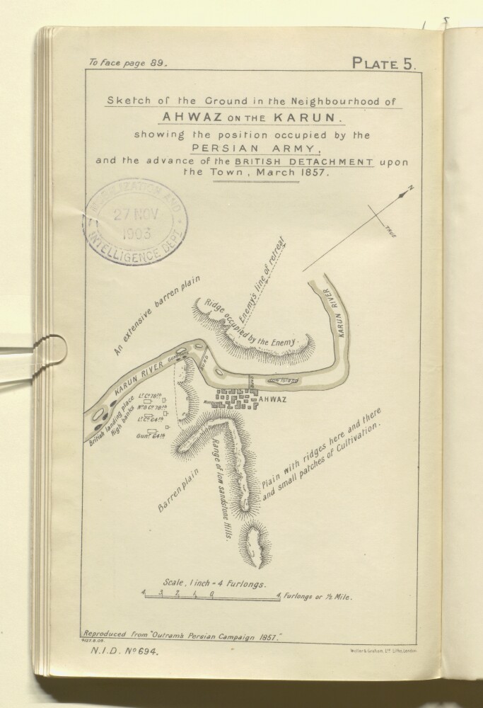
Abstract: The map shows a region around Ahwaz in south-western Persia, indicating the position occupied by the Persian army, and the landing place and advance of British troops. The map also indicates hydrology and buildings, with some indication of relief, and brief descriptions of topography.The map is Plate 5 in 'Persian Gulf and Gulf of Oman' (Naval Intelligence Department No. 694), 1903, and is 'Reproduced from "Outrams Persian Campaign 1857"'.A printing statement reads, 'Weller & Graham, Ltd. Litho, London.'.Physical description: Materials: Printed on paperDimensions: 213 x 127mm, on sheet 244 x 148mm
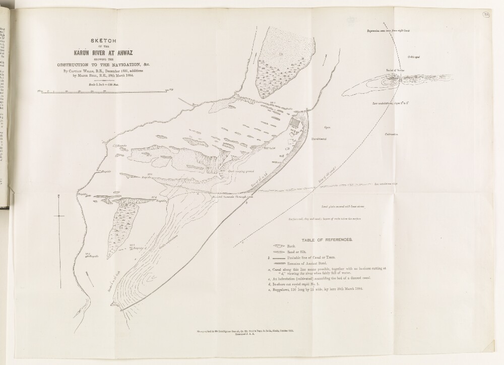
Abstract: Sketch map of the Karun River at Ahwáz [Ahvāz], showing obstructions to the river’s navigation, produced by Captain Henry Lake Wells of the Royal Engineers, in December 1881, with additions made by Major Mark Sever Bell of the Royal Engineers, on 28 March 1884. The map, with accompanying key, indicates: rocks; sand and silt banks; rapids; the remains of an ancient bund, or embankment; the probable line of a canal or tram; buildings at Ahwáz, including mosque and fort; the nature of land on the right bank of the river (cultivated, uncultivated, good camping ground, level plain). Numbered annotations on the map refer to descriptions, written by Wells, in the enclosing volume (ff 87-88).A note at the bottom of the map states that the map was produced in the Intelligence Branch of the Quartermaster General’s Department in India, Simla, October 1884, and examined by ‘J.A.A.’Physical description: Dimensions: 420 x 580 mm.Materials: Printed on paper.
Abstract: The volume contains a chronological list of brief summaries of papers relating to the activities of the Indian Expeditionary Force D between 1 February and 28 February 1915. This is accompanied by appendices containing copies and extracts of these papers, which include: letters, telegrams, reports, notes, tables, extracts of intelligence summaries, and memoranda.A summary of the contents of this volume can be found at folio 5, and the volume concerns:Troop movements and arrivals at Ahwaz [Ahvaz]The position of Turkish [Ottoman] divisionsReinforcements for Force DThe obstruction in the Shatt-al-Arab River caused by the sinking of the
EkbatanaA report that Bin Saud [‘Abd al-‘Azīz bin ‘Abd al-Raḥmān Āl Sa’ūd] has defeated Bin Rashid [Saʿūd bin ʿAbd al-ʿAzīz Āl Rashīd]Arrival of the Germans at Baghdad and the actions of the German consuls in Persia [Iran]An agreement by Australia to send flying officersThe political position of the Shaikh of Muhammareh [Khorramshahr]River levelsSending suppliesThe situation at Basrah [Basra] and Qurneh [Al Qurnah]The spread of 'jehad' [jihad] and its effects, especially on the Baviyeh [Bāwīya] tribeThe arrest and deportation of German representatives of Messrs Wonckhaus.A table of the distribution of the Turkish Army is present on folios 167-172. A statement of the strength of reinforcements for Force “D” is present on folios 176-178.Summaries of the contents of previous volumes can be found at folios 3-4.Physical description: The foliation sequence commences at the front cover with 1 and terminates at the inside back cover with 180; these numbers are written in pencil, are circled, and are located in the top right corner of the recto side of each folio. An additional foliation sequence is also present in parallel between ff 6-178; these numbers are printed and are located in the bottom centre of the recto side of each folio.Dimensions: 21x33cm
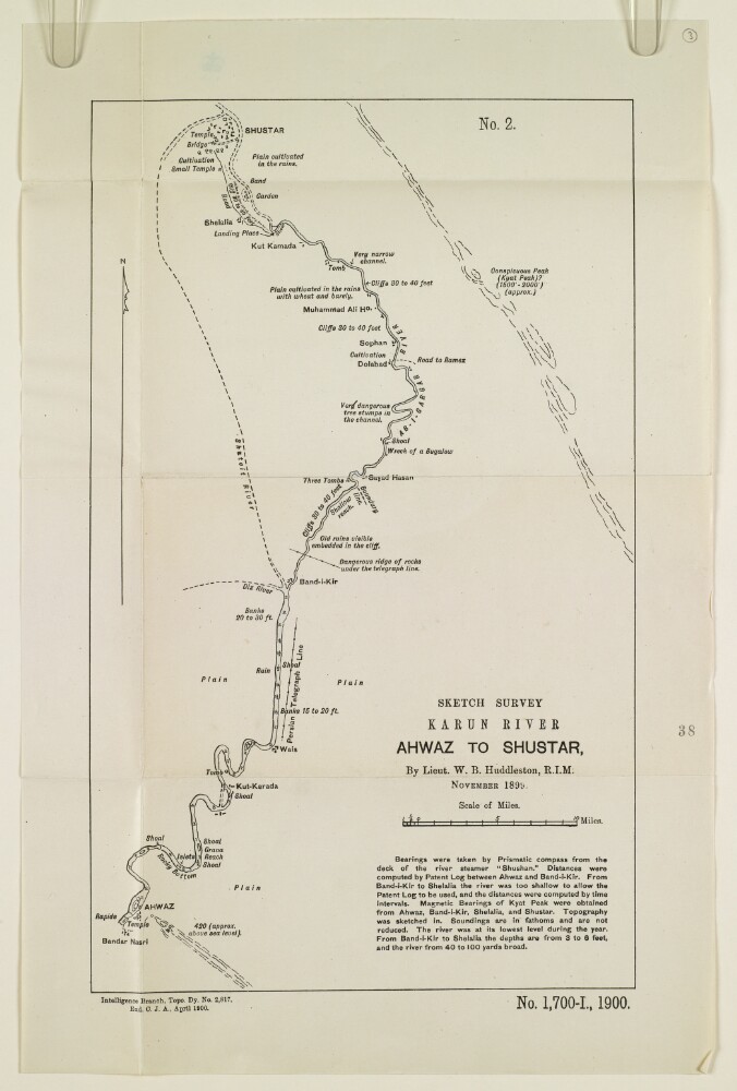
Abstract: The sketch map shows the course of the river Karun from Ahwaz [Ahvāz] to Shushtar, based on a survey undertaken by Lieutenant Willoughby Baynes Huddleston of the Royal Indian Marine in November 1899. The map indicates: the course and nature of the river; soundings, measured in fathoms; the height of banks, shoals; channel hazards; plains; notable landmarks; roads; and river tributaries. A note below the map title states that the bearings were taken by prismatic compass from the deck of the river steamer
Shushtan, at a time of year when the river was at its lowest annual point. The note gives further information on the methods used to record river measurements and bearings.Other labels on the map: at the top, ‘No. 2’; at the bottom: ‘Exd C.J.A.’Physical description: Dimensions: 354 x 217 mm, on sheet 419 x 275 mm.Materials: Printed on paper.
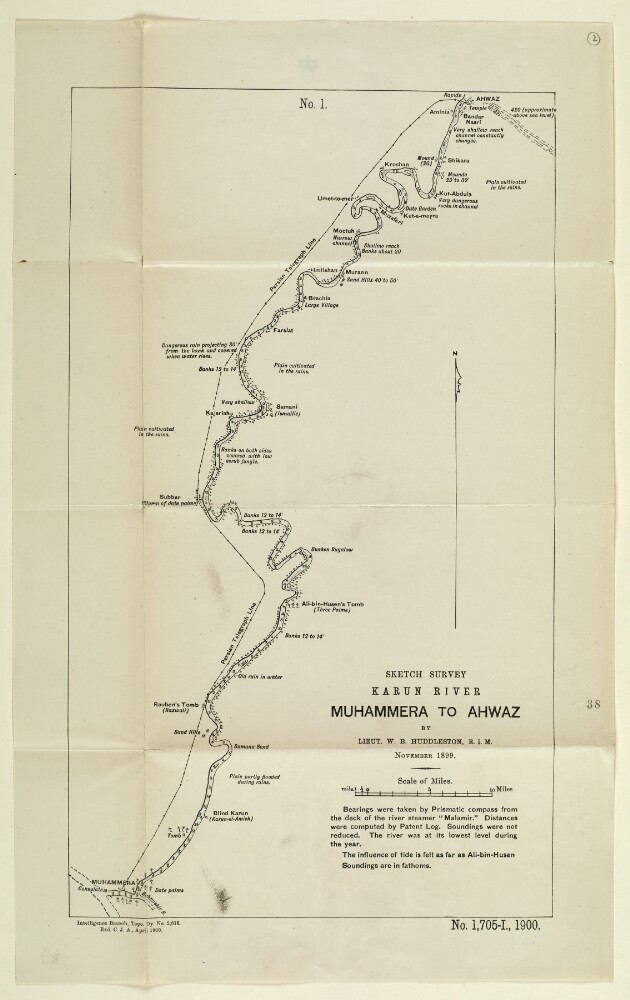
Abstract: Sketch map showing the course of the river Karun from Muhammera [Khorramshahr] to Ahwaz [Ahvāz], based on a survey undertaken by Lieutenant Willoughby Baynes Huddleston of the Royal Indian Marine in November 1899. The map indicates: the nature and course of the river; soundings, measured in fathoms; the height of banks, given in feet; plains; villages; and other features, such as tombs and mounds. A note below the title of the map states that bearings were taken with a prismatic compass from the deck of the river steamer
Malamir, at a time of year when the river was at its lowest annual point.Other labels on the map: at the top, ‘No. 1’; at the bottom: ‘Exd C.J.A.’Physical description: Dimensions: 406 x 244 mm, on sheet 486 x 302 mm.Materials: Printed on paper.
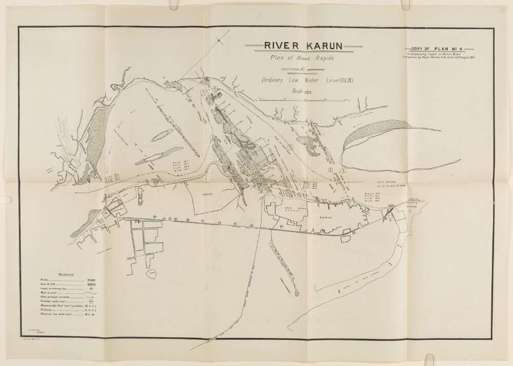
Abstract: This item is a plan of the River Karun and shows the Ahwaz Rapids at ordinary low water level. In the top right-hand corner, the following is printed: 'Copy of Plan 4 accompanying report on Karun River Irrigation by Major Morton R.E. dated 23 August 1907'. The plan provides the names of key settlements, but no further detail. Areas of rocks, sand, silt, tramways and existing and proposed canals are also highlighted. There is a reference key for these features.In the bottom left-hand corner below the neat line is printed: 'M.A. Hakimkhan Draftsman'.Physical description: Materials: Ink on paperDimensions: 460 x 700mm
Abstract: Pencil sketch showing the border region between Iraq and Persia [Iran]. The map indicates the Karun and Bahmanshir rivers, the coastline of the Persian Gulf and the Shatt al-Arab, and the towns of Ahwaz [Ahvāz], Mohammerah [Khorramshahr], and Basrah [Basra]. A red pencil line indicates the border between Iraq and Persia. The map refers to a portion of the report on the same folio, which mentions instructions issued by Persian Government officials to dredge the Bahmahshir ‘to enable all sailing craft to arrive at the Karun River direct from Gusbah [Qoşbeh-ye Manī‘āt] without paying any Port fee to Iraq Government’.Physical description: Dimensions: 60 x 80 mm.Materials: pencil on paper.
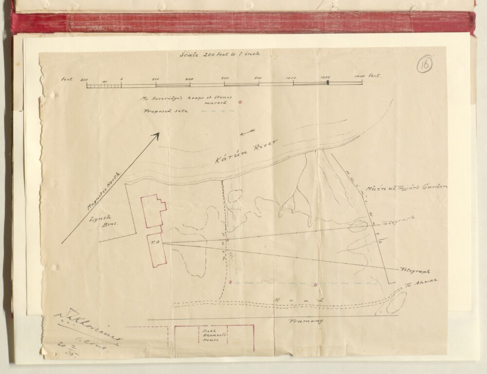
Abstract: Distinctive Features:Hand drawn sketch plan showing land near the Kārun River at Ahwaz with proposed site for the consulate indicated by blue pecked line. Properties outlined in colour and labelled for reference with dimensions inserted in pencil. Signed at the bottom left-hand corner.Physical description: Materials:Pen and ink with crayon on paperDimensions:227 x 300 mm
Abstract: The volume comprises telegrams, despatches, correspondence, memoranda, and notes, relating to administration of the estate of Mr W N Sequeira, a British citizen who had gone bankrupt.The discussion in the volume relates to the situation with the creditors in Khuzistan and legal position with the Iranian government.The principal correspondents in the volume include: HBM Minister, British Legation, Tehran, Herbert Thompson Knatchbull-Huggeson; the Secretary of State for Foreign Affairs; and HM Consul, Ahwaz.Physical description: This is part of a physical volume which contains multiple files. Foliation: the foliation sequence for this description (used for referencing) commences at f 3, and terminates at f 48, as it is part of a larger physical volume; these numbers are written in pencil, and are located in the top right corner of the recto side of each folio. An additional foliation sequence is present in parallel between ff 5-48; these numbers are also written in pencil, but are circled.
Abstract: Consular diaries detailing affairs in Ahwaz [Ahvāz], Persia [Iran]. The diaries were submitted on a fortnightly basis by the British Consul at Ahwaz, although for some periods they were submitted monthly. The diaries cover the period of the Second World War and the Anglo-Soviet occupation of Iran, beginning in August 1941. Subjects covered in the diaries include: the actions of the local Persian administration, including the movements of local Persian officials; the economic situation, including agricultural production, harvests, irrigation, food supply and prices; tribal affairs in the surrounding region, with frequent reference to the Bakhtiari, Kughilu (also spelt Kuh Galu) and Arab tribes, tribes in Luristan [Lorestān], and their relations with the Persian authorities; the movements of foreigners; internal security; public health; local politics and elections; communications, including roads and railways; meteorological observations; British interests, including the movements of British officials and British subjects; Soviet interests; propaganda and public opinion.The file includes a divider, which gives a list of correspondence references contained in the file by year. This is placed at the back of the correspondence.Physical description: Foliation: the foliation sequence (used for referencing) commences at the front cover with 1, and terminates at the inside back cover with 334; these numbers are written in pencil, are circled, and are located in the top right corner of the recto side of each folio. A previous foliation sequence, which is also circled, has been superseded and therefore crossed out.
Abstract: Monthly consular diaries submitted by HM Consul-General at Ahwaz [Ahvāz] in Persia [Iran]. The diaries cover the period January 1946 to December 1947, and describe affairs in Ahwaz under various subheadings. Subjects covered include: British officials and visitors; the evacuation of British troops from the region as part of an Anglo-Soviet agreement following the end of the Second World War; Persian officials and visitors; movements of foreigners; Soviet interests; communications, including railways and postal services; agricultural production, including food supply, food prices, and price controls; tribes, including the Bakhtiari; local politics, including the activities of local political parties, in particular the Tudeh Party of Iran; local elections; local press; internal security, and Persian military activities in the region; regional affairs, including the region’s Arab population and affairs in Luristan [Lorestān]; health, including diseases and medicine; education; meteorological observations, including rainfall statistics; the affairs of the Anglo-Iranian Oil Company (AIOC), including a description of events at Abadan on 14 July 1946, in which a riot at the AIOC refinery resulted in the deaths of at least twenty-four people (ff 39-42). Also included in the file is a report entitled an ‘Appreciation of local conditions from November 1945 to May 1946’ (ff 44-48).The file includes a divider, which gives a list of correspondence references contained in the file by year. This is placed at the back of the correspondence.Physical description: Foliation: the foliation sequence (used for referencing) commences at the inside front cover with 1, and terminates at the last folio with 111; these numbers are written in pencil, are circled, and are located in the top right corner of the recto side of each folio.