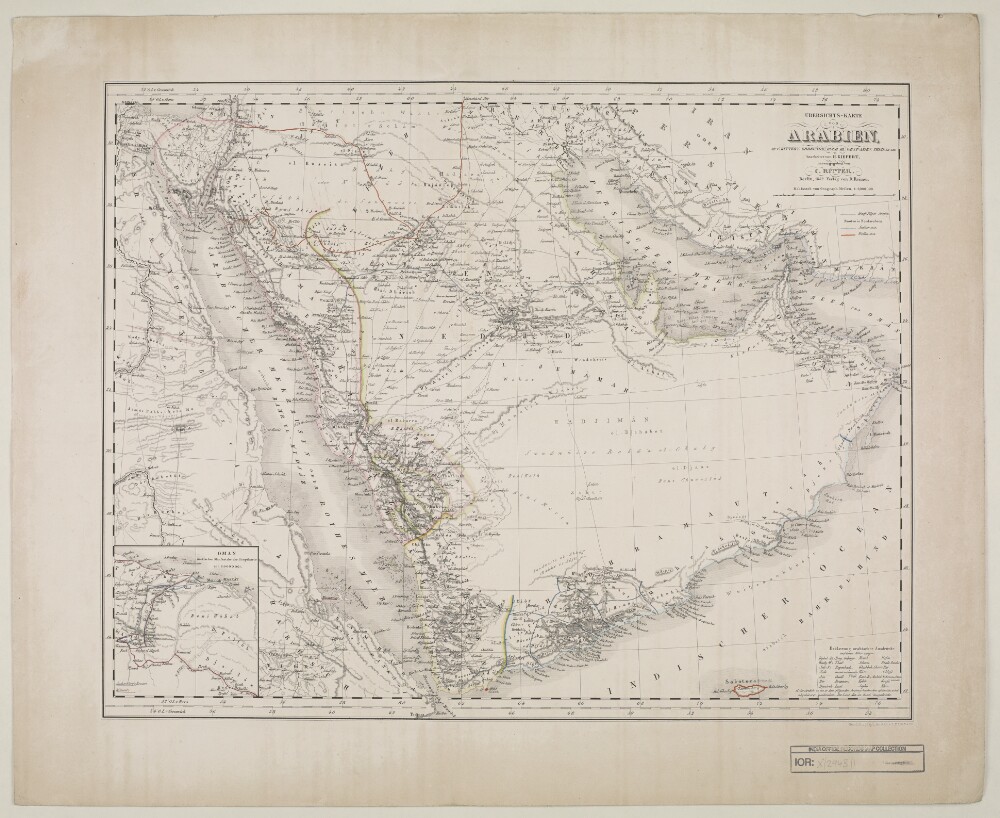
Abstract: Distinctive Features:Relief shown by hachures.Title continues: ‘Zu C. Ritter’s Erdkunde, Buch III, West-Asien, Theil XII, XIII; bearbeitet von H. Kiepert, herausgegeben von C. Ritter. Berlin, 1852 Verlag von D. Reimer’.General map of Arabian Peninsula based on Carl Ritter’s ‘Die Erdkunde im Verhältnis zur Natur und zur Geschichte des Menschen’ [Geography in relationship to nature and to the history of humanity] showing various routes across the region including the Hajj pilgrimage, Captain George Forster Sadlier’s expedition of 1819 and George August Wallin‘s journey of 1848. Provinces and regions labelled with boundary coloured for reference.Includes inset map entitled ‘Oman’ showing Maskat [Muscat] with routes traversed by Pierre-Martin-Rémi Aucher-Eloy and James Raymond Wellsted marked. In the bottom right-hand corner there is a table of reference listing Arabic geographic terms with German equivalents and abbreviations.Physical description: Dimensions:353 x 475 mm, on sheet 742 x 580 mm
Abstract: The volume contains a variety of papers relating to trade in the Red Sea and the Persian Gulph [Gulf]. The volume is organised into four parts, with contents summarised on folio 4:Papers relating to trade with Suez, 1773-78: proceedings, letters, representations and answers (ff 5-57)Trade with Arabia and Persia: report of the Resident at Bushehr [Bushire, also written in the volume as Busheer] and the Resident and joint factors at Bussora [Basra, also written as Busshorah], 1790-91 (ff 55-139)Survey of the Abyssenian [Abyssinian] and Nubian Coast by Lieutenants Court and Maxfield, 22 July to 3 August 1825 (ff 140-154)Memoir by Captain Sealy of the Gulph of Persia, 1813 (ff 155-196).The papers in the volume cover the period 1773-1813, with the exception of one item dated 1825.The first part, dated 1773-78, regards attempts by the East India Company to set up trade in Suez, and the opposition of the Ottoman Government. The matter is discussed in letters, memoranda, reports and extracts of Bengal Public Consultations. The principal correspondents are: officials of the East India Company; the Ottoman Porte [Sublime Porte, Government of the Ottoman Empire]; Robert Ainslie, British Ambassador to the Ottoman Empire; and Mehmed Pasha, Grand Vizir [Meḥmed Pāshā, Grand Vizier].The second part of the file consists of a report relating to the commerce of Arabia and Persia by the Resident at Bushire and the Resident and joint factors at Bussora. The report was signed at Bussora on 15 August 1790 by Samuel Manesty and Harford Jones. The report is preceded by an extract of a Bombay commercial consultation dated 25 February 1791 (f 58) and a list of different goods brought to Bushire from different parts of Hindoostan [India] (ff 58-62), as well as a letter by C Watkins.The third section consists of two letters to the Bombay Marine Board from Lieutenant Mayfield, describing his visit to the Abyssenian and Nubian coasts with Lieutenant Court. This is followed by letters from the Superintendent of the Marine. The fourth part is a memoir of a chart of the Gulph by Captain Henry William Sealy. In this memoir are recorded descriptions of places and cities (i.e. Persian coast, Muscat, and Bushire); also mentioned are remarkable objects, the longitude of the coast, ships and harbours sighted, and other remarks.Physical description: Foliation: the foliation sequence (used for referencing) commences at the inside front cover with 1 and terminates at the inside back cover with 199; these numbers are written in pencil, are circled, and are located in the top right corner of the recto side of each folio.Pagination: the file also contains an original pagination sequence.
Abstract: The item consists of copies and extracts of correspondence, minutes and resolutions cited in, or enclosed with, letters to and from the Government of Bombay and the Government of Bengal. The item relates to the decision to re-establish a Resident or Agent of the East India Company at Mocha in order to pursue commercial and political objects in the 'Arabian Gulph' – comprised of the Red Sea, Egypt and Abyssinia [Ethiopia]. In particular the item is concerned with:The principal objects of the position, namely: the extension of trade in the Arabian Gulph; the procurement of intelligence on the activities of the French in the area; and the establishing of communication routes with Europe via Egypt and MaltaDiscussions of the likelihood of success of the above objects and the validity of the mission, including consultation with the Superintendent of Marine for the Government of Bombay on the channels of conveyance for packetsThe appointments of Captain Henry Rudland as Resident at Mocha and John Benzoni as his Assistant, including consultation with the Auditor of Civil Accounts regarding their allowancesReports by Rudland, Benzoni and the Custom Master at Bombay on the trading of goods in the Arabian Gulph, particularly in Abyssinia.Correspondents include: Court of Directors of the East India Company; Government of Bombay; Government of Bengal; Dr J Pringle, [Previous] Resident at Mocha; William Taylor Money, Superintendent of Marine, Government of Bombay; Mr Petrucy, Swedish Consul General to Alexandria; William Smith, Acting Commissary of Stores, Bombay; Rudland; Benzoni; Peter Paré Travers, Custom Master, Bombay; John Elphinstone, Auditor of Civil Accounts.The title page of the item contains the following references: 'Political No. 27, Season 1809/10, Draft 186' and 'Examiner's Office November 1809'.Physical description: Foliation: the foliation sequence for this description (used for referencing) commences at f 50, and terminates at f 109, as it is part of a larger physical volume; these numbers are written in pencil, are circled, and are located in the bottom right corner of the recto side of each folio.Pagination: the volume also contains an original pagination sequence.
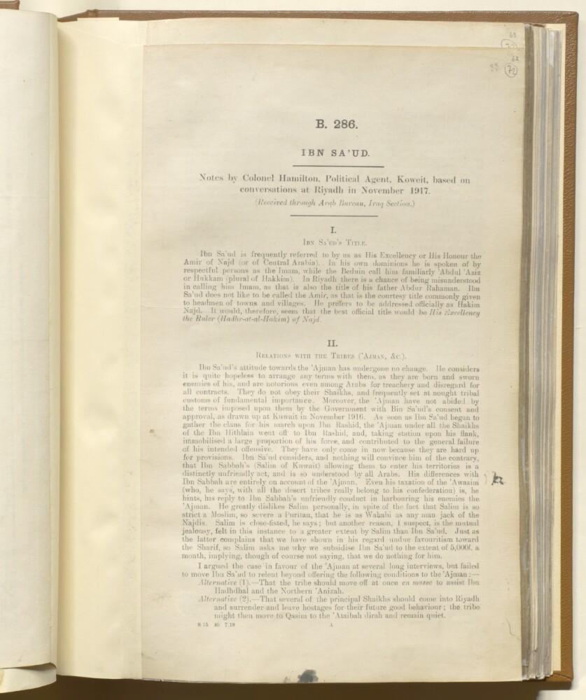
Abstract: This printed memorandum is a report by Colonel Robert Edward Hamilton, Political Agent at Kuwait, received through the Arab Bureau, Iraq Section, concerning ‘Abd al-‘Azīz bin ‘Abd al-Raḥmān bin Fayṣal Āl Sa‘ūd. The report, based on conversations the author had in Riyadh in November 1917, is split into five sections concerning Ibn Sa‘ūd's title, his relations with the tribes (including the Ajman), the question of the capture of Hail [Ḥā’il], his attitude towards King Husain [Ḥusayn bin ‘Alī al-Hāshimī], King of the Hijaz, and Ibn Sa‘ūd's desiderata.Physical description: Foliation: The foliation for this description commences at folio 72, and terminates at folio 74, as it is part of a larger physical volume; these numbers are written in pencil, are circled, and are located in the top right corner of the recto side of each folio. An additional foliation sequence is also present in parallel between folios 11-158; these numbers are also written in pencil, but are not circled, and can be found in the same position as the main sequence.
Abstract: The note was written by Sir Frederic Arthur Hirtzel for the India Office, 30 Nov 1918, and consists of remarks on three points drawn out from the Foreign Office memorandum:The Trucial System - disputing the assumptions made in the original memo that Great Britain effectively kept the peace over a large part of the Arabian Peninsula; and that no treaties had been made with Chief's of inland tribes, that all had been coastal tribes. Stating that the object of the treaties was maritime peace; that His Majesty's Government had always been firmly against interference in the interior of Arabia; the terms of the existing treaty with Bin Saud [‘Abd al-‘Azīz bin ‘Abd al-Raḥmān bin Fayṣal Āl Sa‘ūd, Ibn Saud]; and the India Office's opinion that there would be no benefit to extending the trucial system to the interior of Arabia.The Hejaz - detailing the India Office's thoughts on what a treaty with the King of Hejaz should consist of and how diplomatic relations should be handled.Syria - regarding what the alternative approach to Syria should be if the French refuse to give it up, and citing the opinions of Captain Wilson and Gertrude Bell that the French should be persuaded to give up some areas of Syria within their control for Armenia.Mention is also given to the Baghdad Railway and the importance of ensuring that it is British controlled.The appendix to the note contains further details on the British Government's agreement with Bin Saud, setting out the full history of events leading up to the signing of the agreement; later modifications to it; and the definition of the term 'foreign power' within the treaty.Physical description: Foliation: The sequence commences at the first folio and concludes on the last folio. It consists of pencil numbers, enclosed in a circle, located in the top right hand corner of the recto of each folio.Pagination: The booklet also has an original typed pagination sequence, with numbers printed at the centre of the top of each page, excepting page 1.
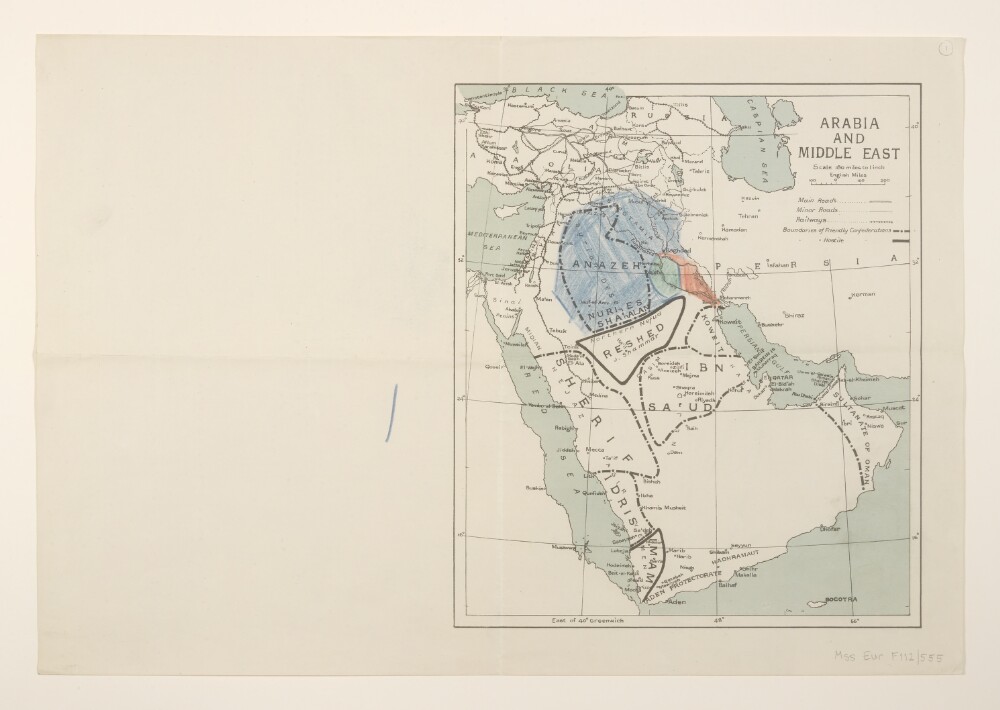
Abstract: Covers the Arabian Peninsula and Middle East. Portrays hydrology, railways, roads, settlements, place names and, within the Arabian Peninsula, the boundaries and names of 'friendly' and 'hostile' confederations. Manuscript additions show unreferenced supplementary shaded areas.Creation date derived from railway information and date of Arab Revolt.Verso bears the annotation 'Arabia & Mesopotamia'.Other copies of the printed map are filed at Mss Eur F112/552, ff 3-4; a similar manuscript map is at Mss Eur F112/552, f 10.Physical description: Materials: Printed in colour, with manuscript additions in crayonDimensions: 306 x 262mm, on sheet 369 x 536mm
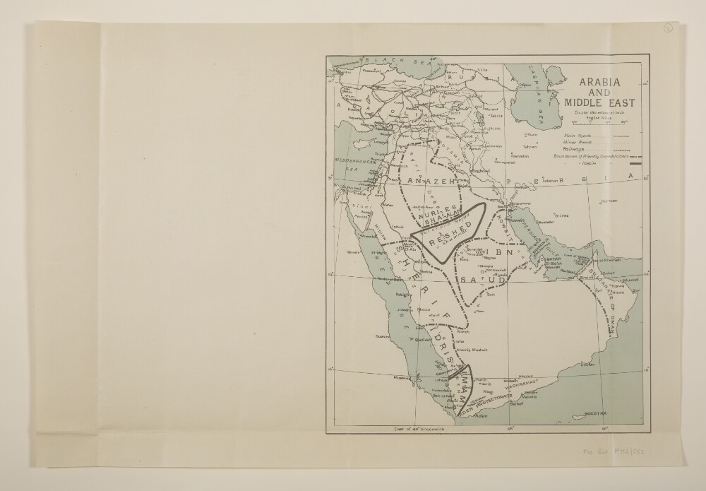
Abstract: Two identical map sheets covering the Arabian Peninsula and Middle East. Sheets portray hydrology, railways, roads, settlements, place names and, within the Arabian Peninsula, the boundaries and names of 'friendly' and 'hostile' confederations. (Another copy at Mss Eur F112/555, f 1 and Mss Eur F112/552, f 10 which portrays similar information in manuscript.)Creation date derived from railway information and date of Arab Revolt.Folio 3 bears the annotation 'Red Sea Arabia' on the verso; folio 4 bears pencil additions in the margin and the annotation 'Arabia' on the verso.Physical description: Materials: Printed in colour, with manuscript additions in pencilDimensions: 306 x 262mm, on sheet 369 x 536mm
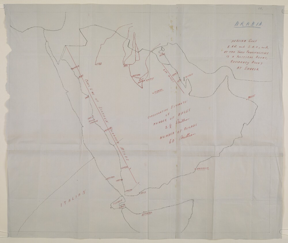
Abstract: Distinctive Features:Hand drawn rough sketch map of the Arabian Peninsula enclosed with letter no. C-436 dated 27th December 1938, sent to Sir Trenchard Fowle, Political Resident in the Persian Gulf, Bushire.Produced to illustrate the European powers involvement and control over the region in relation to arms traffic. Places of interest inserted in red ink, with estimated number of rifles and rounds, and approximate length of coastline in miles reported.Physical description: Materials:Pen and ink on paperDimensions:496 x 595 mm, on sheet 531 x 628 mm
Abstract: This volume contains geographical, social and economic information on Arabia and was produced by the Naval Staff Intelligence Department, June 1919.It is divided into two sections: 'Geography'(folios 3-8) and 'Man' including 'Race, Language and Religion', 'Manners and Custom', 'Economic Capacity of Inhabitants' and 'Distribution and Density of Population' (folios 8v-13).Physical description: Foliation: there is a foliation sequence, which is circled in pencil, in the top right corner of the recto of each folio. It begins on the front cover, on number 1, and ends on the inside of the back cover, on number 14. There is an original pagination, from 4-24.
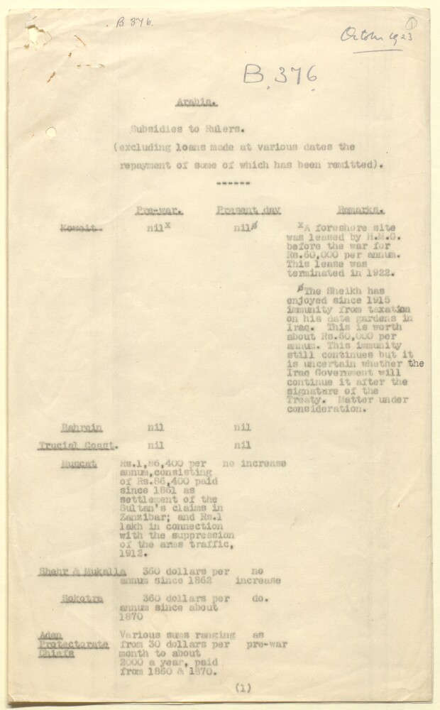
Abstract: Typewritten summary, dated October 1923, listing the subsidies paid by the British Government to rulers on or in the waters around the Arabian littoral. A note underneath the title states that the list excludes loans made at various dates, some of which have been remitted. The list is tabulated, with places listed on the Y-axis as follows: Koweit [Kuwait], Bahrain, Trucial Coast, Muscat, Shehr [Ash-Shiḥr], & Mukalla [Al-Mukallā], Sokotra [Suquṭrā], the Aden Protectorate, Yemen, Asīr, Hedjaz [Hejaz], Nejd [Najd], and the regions inhabited by the Anazeh [Anazzah] tribe, and others bordering onto Trans Jordanis [Jordan] and Iraq. Along the X-axis are three columns for pre-war subsidies, post-war subsidies, and remarks. The table includes, where applicable, details of the amounts paid per annum, and the year of first payments.Physical description: Foliation: The foliation sequence commences at the first folio and terminates at the last folio; these numbers are written in pencil, are circled, and are located in the top right corner of the recto side of each folio.
Abstract: This printed report contains a memorandum by Major Harold Richard Patrick Dickson, Political Agent, Bahrein [Bahrain], dated 12 August 1920, concerning the political situation in Nejd [Najd] and Central Arabia at the end of July 1920, gathered from conversations with Abdul Aziz Al Qusaibi [‘Abd al-‘Azīz al-Quṣaybī], the agent at Bahrain of Bin Saud [‘Abd al-‘Azīz bin ‘Abd al-Raḥmān bin Fayṣal Āl Sa‘ūd, Ibn Saud]; Fahad Al Bassam [Fahad Āl Bassām], merchant of Qassim [al-Qaṣīm] and Hassa [al-Aḥsā’]; Muhammad Al Hawwas [Muḥammad Āl Ḥawwās], merchant of Riyadh and Hassa; and Bedouin visitors from Bani Hajar [Banī Hājir], Bani Khalid [Banī Khālid], Dawasir [al-Dawāsir] and other tribes. The note primarily focuses on Ibn Saud's relations with Ibn Rashīd.Physical description: Foliation: The foliation for this sequence commences at folio 131, and terminates at folio 134, as it is part of a larger physical volume; these numbers are written in pencil, are circled, and are located in the top right corner of the recto side of each folio. An additional foliation sequence is also present in parallel between folio 7-153 of the volume; these numbers are also written in pencil, but are not circled, and can be found in the same position as the main sequence.
Abstract: Imprint:London, engraved by J.&C. Walker.Distinctive Features:Title continues: ‘L.L.D. Honourable Foreigner Secretary of the Syro-Egyptian Society of London. M. Geographical Society of Paris. Corresponding Member of the Oriental Society of Germany &c. Drawn for Colonel Chesney's work on his Euphrates expedition’'From European and Oriental sources; among the latter Ibn Khordadbeh'.Relief shown by hachures.Notations concerning the regions and topography, pilgrim routes, tribes cover the face of the map.Inscriptions:On recto in the left-hand corner: ‘To [illegible] by his humble servant Wm. Plate’.Physical description: Dimensions:645 x 600 mm