Abstract: The item consists of three letters from the Government of Bombay to the East India Company Court of Directors, dated 1 October 1846-31 March 1847. The letters refer to attempts to suppress the ‘slave trade’ [trade in enslaved people] in the Imaum [Imam] of Muscat’s dominions and on the Arabian Coast of the Persian Gulf. Enclosures to these letters can be found at: IOR/F/4/2191/107337; IOR/F/4/2191/107338; IOR/F/4/2191/107339; and IOR/F/4/2191/107340. The item is the first in a series of five items on the ‘slave trade’.Extracts of a letter from the Court of Directors to the Government of Bombay, dated 18 November 1846, are included.Additionally, the item contains examples of two forms to be filled in by officers of the Company’s Indian Navy upon seizing vessels engaged in the ‘slave trade’.The title page of the item contains the following references: ‘Bombay Political Department’, ‘P.C. [Previous Communication] 5698, Draft 542/47, Collection Vol: 1’, and ‘Examiner’s Office’.Physical description: Foliation: the foliation sequence for this description (used for referencing) commences at f 71, and terminates at f 80, as it is part of a larger physical volume; these numbers are written in pencil, are circled, and are located in the bottom right corner of the recto side of each folio.Pagination: the item also contains an original pagination sequence.
Abstract: This volume contains geographical and strategic information on Arabia and was produced by the Naval Staff Intelligence Department, October 1941.It is divided into six sections: 'Policy', 'Strategy and Tactics', 'Economics' (folio 4) 'Geography and Topography' (folios 4v-10), 'Base Facilities and Maintenance of the Fleet' (folios 10v-11) and 'Ports, Anchorages and their Defences' including descriptions of several ports in the Region: Akaba, Bahrain, Doha, Hodeida and Ras Kethib, Jedda, Kamaran, Kuwait, Mukalla, and Muscat (folios 11v-25).There is a 'List of Plans' of the ports (folio 3), but none of the plans listed are enclosed to the volume.Physical description: Foliation: there is a foliation sequence, which is circled in pencil, in the top right corner of the recto of each folio. It begins on the front cover, on number 1, and ends on the inside of the back cover, on number 26. There is also an original pagination, from 1-45.
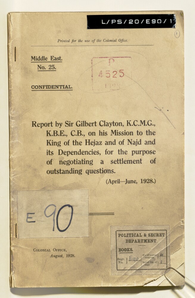
Abstract: This printed booklet, produced by the Colonial Office in August 1928, is an account of Sir Gilbert Clayton, His Britannic Majesty's Commissioner and Plenipotentiary, on the first part of his third mission (April-June 1928) to ‘Abd al-‘Azīz bin ‘Abd al-Raḥmān bin Fayṣal Āl Sa‘ūd (Ibn Saud), King of Hejaz [al-Ḥijāz] and Najd and its Dependencies. The purpose of the mission was to negotiate outstanding questions mainly concerning boundaries of and relations between Ibn Saud's territories and Iraq and Trans-Jordan following the Hadda and Bahra Agreements of 1925, and the Treaty of Jeddah of 1927.Clayton was accompanied by George Antonius, Assistant Secretary to the Palestine Government; Kinahan Cornwallis, Adviser to the Ministry of Interior in Iraq; Captain John Bagot Glubb, Administrative Inspector in the Iraq Government Service; Flight-Lieutenant G M Moore; and Bernard Henry Bourdillon, Counsellor to the Residency in Baghdad. The Najd delegates included: Dr Abdullah Damluji [‘Abdullāh al-Damlūjī]; Shaikh Yusuf Yasin [Yūsuf Yāsīn]; Shaikh Hafez Wahba [Ḥāfiẓ Wahbah]; and Shaikh Fuad Hamza [Fu’ād Ḥamzah].A page of contents and list of annexes appears on folio 2v with the following sections:'Report by Sir Gilbert Clayton, KCMG, KBE, CB' (folios 3-9);'Record of Proceedings' (folios 10-22);'Memorandum and Minutes of the Proceedings of the 'Iraq-Najd Sub-Committee' (folios 23-32);'Memorandum on the Proposed Arbitration between Najd and Trans-Jordan' (folios 33-34)'Notes Exchanged on the Suspension of Negotiations' (folios 34v-35);'Draft Extradition Agreement' (folios 36-27);'Draft Bon Voisinage Agreement' (folios 38-40);'Correspondence Relating to Frontier Incidents, April, 1928' (folios 40v-43).There is one appendix which consists of Colonial Office letters of instruction to Sir Gilbert Clayton, dated 17 April 1928 (folios 43v-47). The front cover is marked 'Confidential' and 'Printed for the use of the Colonial Office'. Clayton's account is continued in 'Middle East No. 28', 'Report by Sir Gilbert Clayton, K.C.M.G., K.B.E., C.B., on his Mission to the King of Hejaz and of Najd and its Dependencies, for the purpose of negotiating a settlement of outstanding questions. (July-August, 1928)' (IOR/L/PS/20/E90/2).Physical description: Foliation: The foliation sequence commences at the front cover, and terminates at the inside back cover; these numbers are written in pencil, are circled, and are located in the top right corner of the recto side of each folio. The volume also contains an original printed pagination sequence.
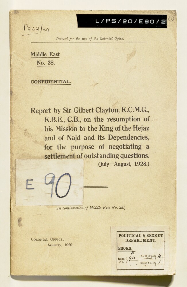
Abstract: This printed booklet, produced by the Colonial Office in January 1929, is a continuation of the April-June 1928 account of Sir Gilbert Clayton, His Britannic Majesty's Commissioner and Plenipotentiary, on the second part of his third mission (July-August 1928) to ‘Abd al-‘Azīz bin ‘Abd al-Raḥmān bin Fayṣal Āl Sa‘ūd (Ibn Saud), King of Hejaz [al-Ḥijāz] and Najd and its Dependencies. The purpose of the mission was to negotiate outstanding questions mainly concerning boundaries of and relations between Ibn Saud's territories and Iraq and Trans-Jordan following the Hadda and Bahra Agreements of 1925, and the Treaty of Jeddah of 1927.Clayton was accompanied by George Antonius, Assistant Secretary to the Palestine Government; Kinahan Cornwallis, Adviser to the Ministry of Interior in Iraq; Captain John Bagot Glubb, Administrative Inspector in the Iraq Government Service; Flight-Lieutenant G M Moore; and Bernard Henry Bourdillon, Counsellor to the Residency in Baghdad. The Najd delegates included: Dr Abdullah Damluji [‘Abdullāh al-Damlūjī]; Shaikh Yusuf Yasin [Yūsuf Yāsīn]; Shaikh Hafez Wahba [Ḥāfiẓ Wahbah]; and Shaikh Fuad Hamza [Fu’ād Ḥamzah].A page of contents and list of annexures appears on folio 2v with the following sections:'Colonial Office to Sir Gilbert Clayton, K.C.M.G., K.B.E., C.B., 19th July, 1928 (Letters of Instructions)' (folios xx);'Sir Gilbert Clayton, K.C.M.G., K.B.E., C.B., to Colonial Office, 3rd September, 1928 (Further Report on his Mission)' (folios XX);'Record of Proceedings' (folios XX);'Memorandum on the Proceedings of the Sub-Committee Meetings' (folios XX);'Draft Note on the Arbitration of Raids between Najd and Trans-Jordan' (folios XX).There is one appendix which consists of a Foreign Office letter to the Acting British Agent and Consul, Jeddah, dated 1 November 1928. The front cover is marked 'Confidential', 'Printed for the use of the Colonial Office' and 'In continuation of Middle East No. 25', 'Report by Sir Gilbert Clayton, K.C.M.G., K.B.E., C.B., on his Mission to the King of Hejaz and of Najd and its Dependencies, for the purpose of negotiating a settlement of outstanding questions. (April-June, 1928)' (IOR/L/PS/20/E90/1).Physical description: Foliation: The foliation sequence commences at the front cover, and terminates at the inside back cover; these numbers are written in pencil, are circles, and are located in the top right corner of the recto side of each folio. The volume also contains an original printed pagination sequence.
Abstract: The volume, marked confidential, is
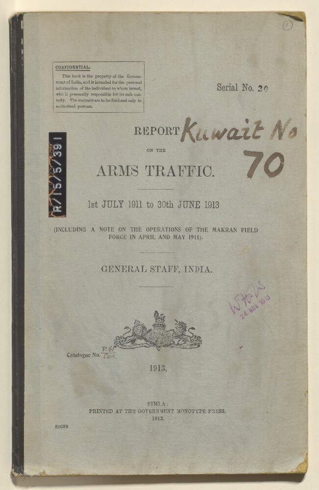
Report on the Arms Traffic, 1st July 1911 to 30th June 1913 (including a note on the operations of the Makran Field Force in April and May 1911), prepared by the General Staff, India, and printed at the Government Monotype Press, 1913. The report begins with a preface (folio 5) and is then divided into seventeen sections, plus appendices. The geographical scope of the report includes Persia, Afghanistan, the Persian Gulf, the Arabian Peninsula, and Turkey. The report covers blockade measures, systems of intelligence, exporters from Europe, and prices.The note on operations of the Makran Field Force comes as an appendix and is written by Captain SG Craufurd, Gordon Highlanders Intelligence Officer, at Jask on 10 May 1911.Physical description: Foliation: the foliation sequence commences at the front cover with 1 and terminates at the inside back cover with 22; these numbers are written in pencil, are circled, and are located in the top right corner of the recto side of each folio.Pagination: the volume also contains an original printed pagination sequence.
Abstract: Covers the Persian Gulf, Gulf of Aden and Red Sea, including hinterlands to a width of approximately 150 miles beyond which detail diminishes. Comprises a base map, overprint and manuscript additions.The base map is produced from British Admiralty Chart No. 748B titled 'Indian Ocean - Northern Portion' dated 15 November 1918 and filed at Maps B.A.C. (748B.). Portrays marine hydrology, including sands, rocks and depths by soundings, inland hydrology, relief by hachures and spot heights, railways, roads and tracks, settlements and place names. Bears the notes 'Drawn for engraving by E J Powell' and 'Engraved by Davies Bryer & Co.'A red overprint portrays the sea line including geographical reference points, some of which possess reference letters although no key is present.Manuscript additions relate to the sea line and also accentuate the coastline.The verso bears the annotation 'Arabia'.Physical description: Materials: Printed in colour, with manuscript additions in crayonDimensions: 290 x 676mm, on sheet 405 x 763mm
Abstract: Southern Arabia, by Theodore Bent, F.R.G.S., F.S.A., Author of 'The Ruined Cities of Mashonaland' 'The Sacred City of the Ethiopians' 'The Cyclades, Or Life Among the Insular Greeks' etc. and Mrs Theodore Bent.Publication details: Reading: Garnet, c 1994.Edition: new edition.Notes: facsimile edition of edition published London: Smith, Elder, & Co., 1900.Physical Description: initial roman numeral paginations i-xi, i-x; 24 leaves of plates, 5 folded leaves of maps; illustrations, 6 maps 1 portrait.Physical description: Dimensions: 240mm x 165mm
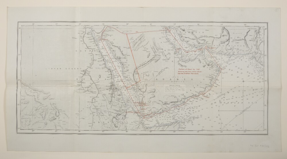
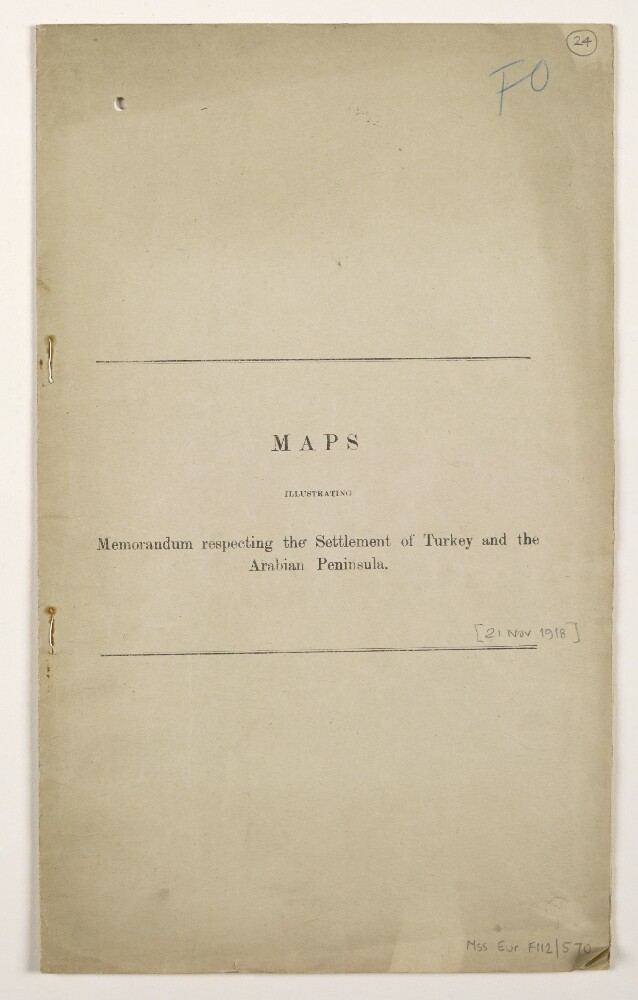
Abstract: Copy of Mss Eur F112/570, ff 17-23.Volume comprising 7 folios numbered 24 to 30. Produced to accompany 'Memorandum respecting the Settlement of Turkey and the Arabian Peninsula' published by the Political Intelligence Department, Foreign Office, 21 November 1918. Includes four map sheets numbered 1, 2, 2A and 3 together with explanatory notes relating to maps 2 and 3; the explanatory notes bear the imprint '[920-1 A]'.Physical description: Materials: Printed in colour, with manuscript additions in crayonDimensions: 340 x 205mm, with fold-out maps 290 x 452mm or smallerBinding: Thin light buff card, bound with two stitches; evidence of previous staples
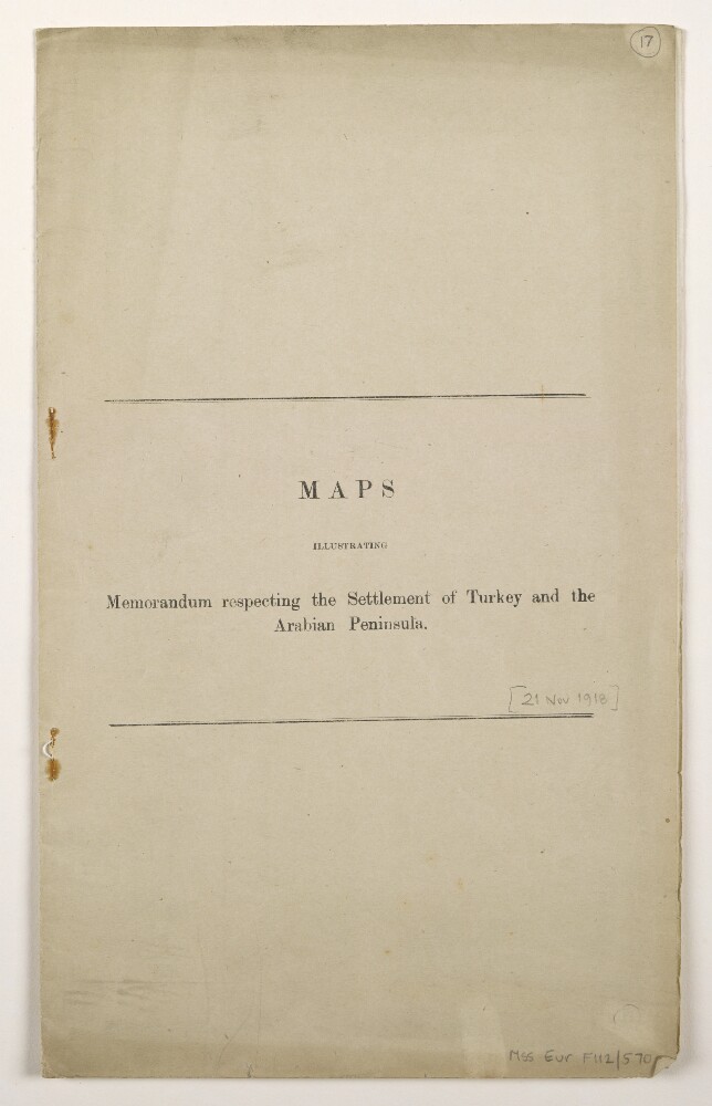
Abstract: Volume comprising 7 folios numbered 17 to 23. Produced to accompany 'Memorandum respecting the Settlement of Turkey and the Arabian Peninsula' published by the Political Intelligence Department, Foreign Office, 21 November 1918. Includes four map sheets numbered 1, 2, 2A and 3 together with explanatory notes relating to maps 2 and 3; the explanatory notes bear the imprint '[920-1 A]'.A second copy is at Mss Eur F112/570, ff 24-30.Physical description: Materials: Printed in colourDimensions: 340 x 205mm, with fold-out maps 290 x 452mm or smallerBinding: Thin light buff card, bound with two stitches; evidence of previous staplesFolio 23 (back cover) lacks lower right corner
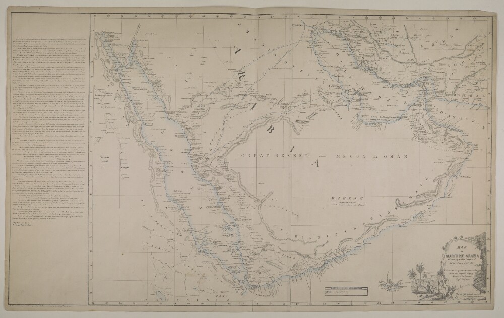
Abstract: Imprint:Lithographed in the Chief Engineer’s Office by Huskelyee E. & Kumroodeen E. Bombay 1st March 1856 Qrt. Master's Generals Offices, Poona 2nd Augt 1855.Distinctive Features:Title continues: 'Reduced in the Quarter-Master General's Office from an original map by Colonel T. Dickinson Chief Engineer’.Bottom right-hand corner: ‘(Signed) Neil Campbell Lieut Con. Acting Quarter Master General’Relief shown by hachures.Title in decorative cartouche.Includes extensive notes on survey and sources used in compiling the map with explanation to symbols and colouring.Notations concerning the country cover the face of the map. Shows various routes including the pilgrimage to Mecca.Physical description: Dimensions:530 x 730 mm
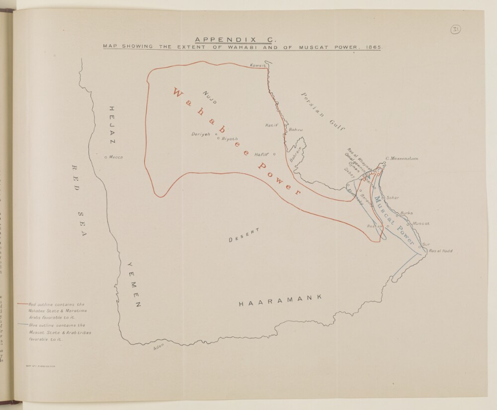
Abstract: Distinctive Features:Issued as an Appendix C in Bushire Despatch to Bombay No. 11 of 14th February 1865 with Wahabee State authority outlined in red and Muscat State limits shown in blue line.Physical description: Dimensions:336 x 415 mm
Abstract: Distinctive Features:Outline map of the Arabian Peninsula issued as an Appendix C in Bushire Despatch to Bombay No. 11 of 14th February 1865 (folios 60-90) with Wahabee State authority marked in red and Muscat State limits shown in blue line.Physical description: Dimensions:327 x 414 mm