Number of results to display per page
Search Results
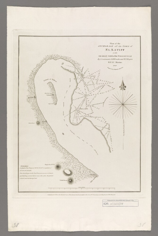
49. 'Plan of the Anchorage off the Town of El Katiff on the Arabian Side of the Persian Gulf'
- Description:
- Abstract: Covers El Katiff [Al Qatif, Saudi Arabia], the surrounding Arabian Peninsula coastline and waters of the Persian Gulf to a radius of up to fifteen miles. Portrays hydrology, including depths by soundings, sands and rocks, relief by hachures, vegetation, settlements, forts and place names, and includes topographical and hydrographic notes.Surveyed by Lieutenants George Barnes Brucks and William Eales Rogers, 1825. Engraved by Bateman and Son. Published by James Horsburgh, Hydrographer to the Honourable East India Company.Physical description: Materials: Printed on paperDimensions: 346 x 270mm, on sheet 501 x 321mm
50. ‘A sketch of the political history of Persia, Iraq and Arabia, with special reference to the present campaign.’
- Description:
- Abstract: The volume is an overview of the political history of Persia, Iraq and Arabia, authored by the Office of the Chief Political Officer, Indian Expeditionary Force “D”, and printed by the Superintendent Government Printing, Calcutta [Kolkata], India in 1917. The volume is divided into a number of chapters:1. An introduction to the political history of Persia, Iraq and Arabia, chiefly concerning Britain’s history of naval intervention and military occupation in the Persian Gulf, and its efforts in eradicating the slave trade, arms traffic and piracy;2. A chapter entitled ‘The Arab attitude in Iraq before the War’, including: political conditions in Turkish Iraq prior to the War; the arrival of the Indian Expeditionary Force “D” at the start of the War; Ottoman ‘jihad’ against the British; Arab attitudes to the British in Iraq, central Arabia and Persian Arabistan;3. British relations with Arabistan, including an overview of the Anglo-Persian War (1856-57), and a brief outline of the Anglo-Persian Oil Company’s activities in the region;4. The Bakhtiari tribes, their leaders and their standing with the Persian Government, and the importance of maintaining British relations with them, with reference to trade routes, the maintenance of order in the oil fields, and the maintenance of friendly relations with the Shaikh of Muhammareh [Khorramshahr] and the Russians at Ispahan [Isfahān, or Eṣfahān];5. Pusht-i-Kuh – ‘the right flank of Indian Expeditionary Force “D”’: a description of the area, and its strategic and economic importance, including: topography; climate; the position and powers of its Wali [governor] (taken from Lorimer’s Gazetteer of the Persian Gulf), the Wali’s relatives; and Kaka Siyah, who reside in the region and who are of African origin;6. Arabia – the left flank of Indian Expeditionary Force “D”. The chapter is divided into two parts. The first part is a general description of the Arabian peninsula, including: topography and geographic features; political powers in Arabia: the Wahhabi, with a history of their development and territorial gains; Egypt; Ibn Rashid [Ibn Rashīd]; the British Government; and Turkish interests in Arabia. The second part is a detailed historical outline of British relations with Ibn Sa‘ūd;7. Entitled The Trend of Turkish policy before the War and since (official), and subdivided into parts on internal and external politics. The first part includes an assessment of the characteristics of ‘Ottoman people’ and their Government, the second concentrates on German influence and activity in Ottoman territories.There are pencil annotations on the front flyleaf of the volume (folio 2), which make note of sections within the volume, with the corresponding page numbers.Physical description: Foliation: There is a foliation sequence, which is circled in pencil, in the top-right corner of the recto of each folio. It begins on the front cover, on number 1, and ends on the inside of the back cover, on number 29.Pagination: A printed pagination system runs through the volume (ff 7-27), the numbers of which are located top and centre of each recto and verso.
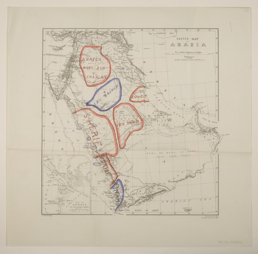
51. 'Sketch map of Arabia'. With manuscript additions showing 'Friendly' and 'Hostile' Confederations
- Description:
- Abstract: Printed sheet bearing the series designation 'I[intelligence].D[ivision].W[ar].O[ffice]. No. 1835' and the imprint 'Corrections, July, 1905. Railways revised Sept. 1906.' Portrays hydrology, relief by hachures, railways, roads, submarine telegraphs, settlements, place names and international boundaries; includes an inset (120 x 98mm) titled 'Map of Koweit and Surrounding Country' at scale 1:2,027,520. Manuscript additions portray 'Friendly Confederations' in red and 'Hostile Confederations' in blue (see also Mss Eur F112/552, ff 3-4, from which this terminology is taken).Creation end date derived from date of Arab Revolt.A colour version of this sheet, without manuscript additions, is filed at Maps MOD GSGS 1835.Physical description: Materials: Printed, with manuscript additions in coloured ink and watercolourDimensions: 385 x 384mm, on sheet 498 x 507mm
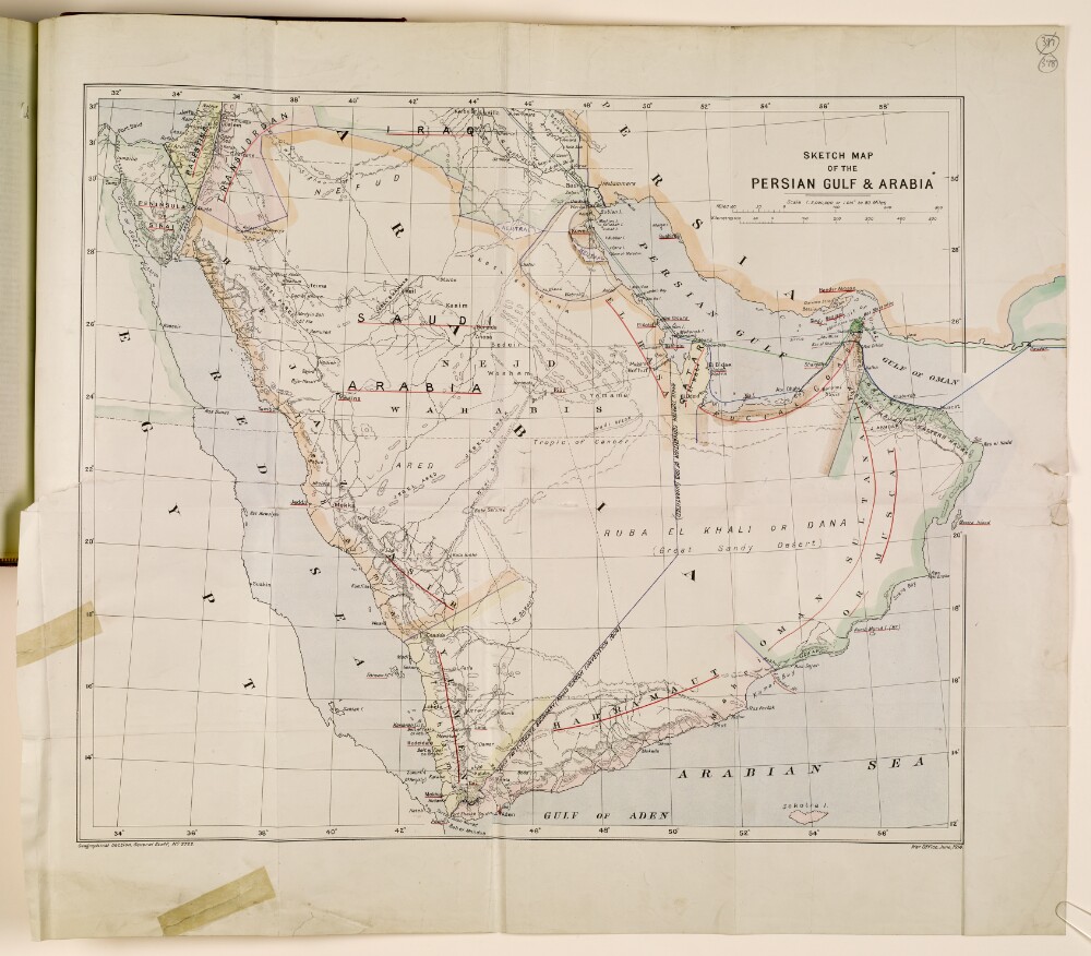
52. 'SKETCH MAP OF THE PERSIAN GULF & ARABIA'
- Description:
- Abstract: Sketch map depicting the Arabian Peninsula, with the Red Sea and the Persian Gulf on either side. The map indicates boundaries, settlements, and hydrology, and provides some indication of relief.The map, which is attributed to the War Office, is dated June 1914 but has a number of annotations in ink, presumably dating from 1932-1934, which reflect the creation of new states (e.g. Saudi Arabia). Significant place names are underlined in red, and each country or region has been colour-coded according to its status.Physical description: Dimensions: 466 x 557mm, on sheet 569 x 643mm.Materials: Printed on paper.
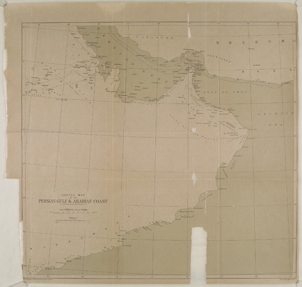
53. 'Sketch map of the Persian Gulf & Arab Coast'
- Description:
- Abstract: Imprint:Topographical Section, General Staff, No. 2037. War Office, March, 1905.Distinctive Features:Printed map of the south-eastern portion of the Arabian Peninsula produced in connection with file on Arbitration by Hague Tribunal on question of French flags on Omani dhows. The ff.58-59A discuss the geography of Oman in reference to Kiepert's map.Contains notations of terrain features and vegetation, with Indo-European overland and submarine telegraph line and roads shown.Physical description: Dimensions:430 x 461 mm, on sheet 482 x 504 mm
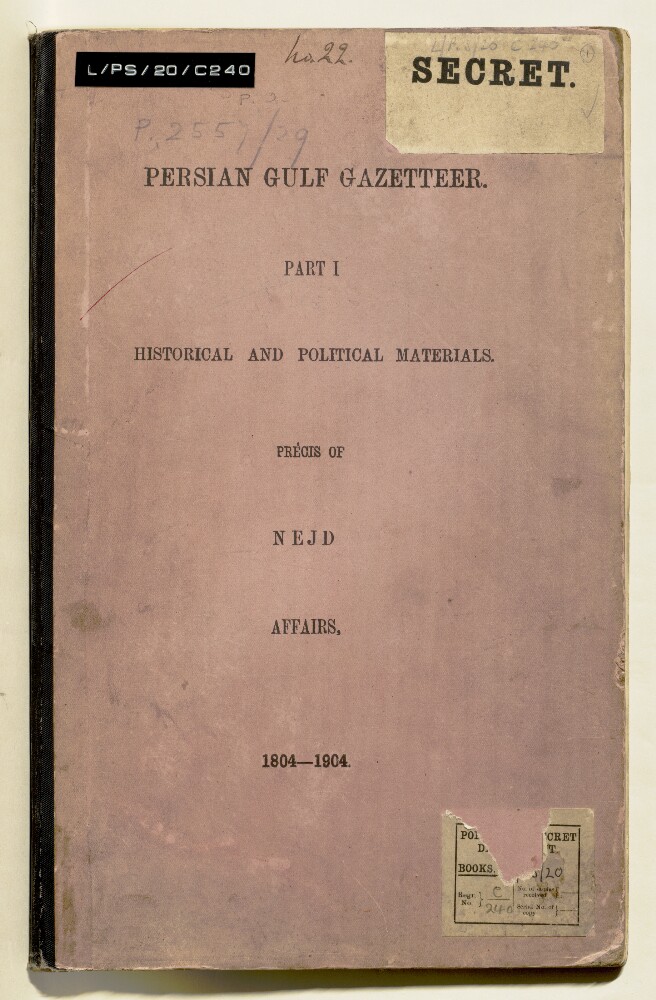
54. 'Persian Gulf Gazetteer. Part I. Historical and Political Materials. Précis of Nejd Affairs, 1804-1904'
- Description:
- Abstract: The volume, stamped ‘Secret’ on the front cover and frontispiece, is part 1 (historical and political materials) of a précis of Najd (spelt Nejd throughout) affairs for the years 1896-1904. It was prepared by Jerome Antony Saldanha of the Bombay Provincial Civil Service, and published in 1904 by the Government of India Foreign Department, Simla, India.The volume includes a preface (folio 3) and list of contents (folio 4). The sections listed in the contents run as follows:I: Rise of the Wahabis under Abdul Wahab [‘Abd al-Wahhāb] ante1740;II: Political History of Nejd ante 1800 to 1804;III: Genealogy of the Wahabi Amirs;IV: First encroachments of the Wahabis on Oman,, 1804-1808;V: (1) Joasami [Āl Qāsimī] pirates under Wahabi influence first venture into the Indian Seas. (2) Expedition against Joasamis and Wahabis, 1808-1809;VI: First Egyptian Invasion of Nejd, 1814-1819;VII: Resurrection of the Wahabis and Reconstitution of the Wahabi Kingdom, 1824-1831;VIII: Wahabi overtures to British Government, 1831;IX: (1) Wahabi Invasion of Oman, 1833. (2) Views of the Government of India as to the claims of Maskat [Muscat] on the British Government;X: (1) Turki [Turkī] murdered by Meshari [Mashārī]. (2) Meshari executed by Feysal [Fayṣal]. (3) Feysal assumes Kingdom;XI: (1) Second Egyptian Invasion of Nejd. (2) Egyptian withdrawal under British pressure;XII: Government of Khalid [Khālid] as Turkish viceregent;XIII: (1) Abdullah bin Saneyan [‘Abdullāh bin Thānīyān] seizes the kingdom. (2) Feysal returns from exile;XIV: (1) Oman again threatened by the Wahabis. (2) British policy;XV: Wahabi attempt on Bahrein [Bahrain]XVI: Invasion of Oman by Abdullah, son of Feysal (2) Treaty between Maskat and Wahabis;XVII: Feysal's nominal dependence upon Turkey, 1855;XVIII: (1) Renewal of Wahabi attempt on Bahrein. (2) British interference, 1859;XIX: (1) Blockade of Wahabi ports by Chief of Bahrein, 1861. (2) Blockade raised on British interference;XX: Turkish protest against British proceedings;XXI: Differences between Sultan of Maskat and Amir of Nejd, 1864-65;XXII: Visit of Colonel [Lewis] Pelly to Riadh [Riyadh], 1865;XXIII: Difference between Sultan of Maskat and Amir of Nejd (continued), 1864-1865;XXIV: (1) Rebellion of two Oman tribes under leadership of Wahabi Officer. (2) Outrage of British subjects;XXV: British operations against the Wahabis, 1865-66;XXVI: The Amir of Nejd comes to terms, 1866;XXVII: Deputation of a Wahabi envoy to Baghdad, 1866;XXVIII: Wahabi advances to Beraymi [al-Buraymī];XXIX: Civil War between Abdullah and Saud [Sa‘ūd], his brother. (2) Turkish expedition into Nejd to assist Abdullah, 1870-71;XXX: Saud bin Feysal's appeal to the Resident for arbitration of the British Government, 1871-1873;XXXI: Saud's negotiations with the Turks, 1872;XXXII: First Mission of Haji Ahmed [Ḥājjī Aḥmad] to Baghdad, 1872;XXXIII: Second Mission of Haji Ahmed to Baghdad, 1872;XXXIV: Visit of Abdullah messenger to Baghdad, 1872-1873;XXXV: Release of Abdur Rahman [‘Abd al-Raḥmān];XXXVI: Death of Saud bin Faysal [Sa‘ūd bin Fayṣal] and election of Abdul Rahman as Amir, 1875;XXXVII: Abdullah bin Feysal [‘Abdullāh bin Fayṣal] defeats Abdur Rahman, 1875-80;XXXVIII: Threatened Revolt of the Montefik Arabs [al-Muntafiq], 1880;XXXIX: Sheikh Abdullah bin Thanneyan, 1879-1880;XL: State of affairs in 1881;XLI: Rise of the Shammar principality, 1835-1882;XLII: Genealogy of Shammar Chiefs;XLIII: Hostilities between Abdullah bin Feysal and Ibn Rashid [Ibn Rashīd];XLIV: Imprisonment of Abdullah bin Feysal and absorption of the Wahabi Kingdom in the Shammar principality, 1887-1896;XLV: Complications with Koweit, 1897-1904.Physical description: Foliation: The foliation sequence commences at the front cover and terminates at the inside back cover; these numbers are written in pencil, are circled, and are located in the top right corner of the recto side of each folio. The volume also contains an original printed pagination sequence.
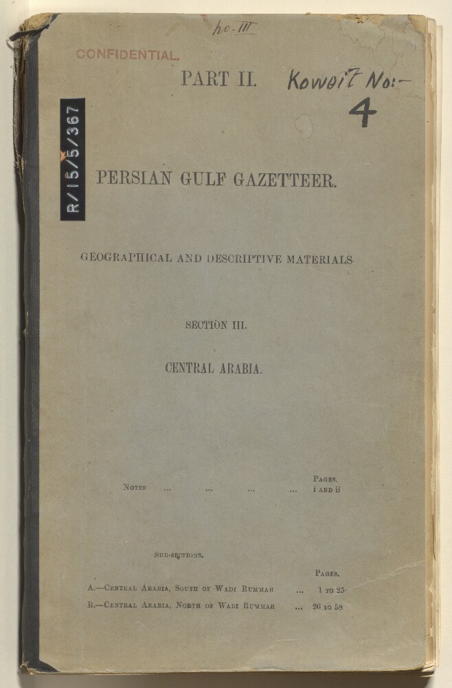
55. 'Persian Gulf Gazetteer, Part II: Geographical and descriptive materials, Section III: Central Arabia.'
- Description:
- Abstract: The volume, marked confidential, is Persian Gulf Gazetteer, Part II: Geographical and descriptive materials, Section III: Central Arabia, compiled by John Gordon Lorimer, and includes the printing statement 'G. C. Press Simla - No. C-905 F. D. - 18.11.04 - 80 - C. G.'. The volume begins with notes from the author, dated 14 November 1904, and is then divided into two subsections, as follows:A - Central Arabia, South of Wadi RummahB - Central Arabia, North of Wadi RummahEach subsection, organised alphabetically by name, contains a variety of geographic information, including towns and villages, districts, physical geography, tribes and tribal sub-sections, wells, and forts.Physical description: 1 volume (125 folios)
56. ‘Wybard Lieutenant Travels in Nedjd in Arabia’
- Description:
- Abstract: The item consists of copies and extracts of correspondence, minutes and resolutions cited in, or enclosed with, letters from the Government of Bombay [Mumbai].The item contains copies of research papers compiled by Lieutenant William Henry Wybard (also written 'J. W.' and 'Wyburd') during his exploration of the Province of Nedjd [Najd] between 1831 and 1833, the purpose of which was to find out more about the Wahabees [Wahabi] and their country. The research papers include:'Journal' (ff 61-69) which documents Wybard's journey from Bushire [Būshehr], via Bahrein [Bahrain] and Katiff [Al-Qatif], into Nedjd where he visited Ajeer [Al ‘Uqayr?] and the town of Elreasa (also written 'Elriasa' and ‘Elhasa’) [Al Hufūf]'Elreasa' (ff 70-71) which includes a description of the town, its defences and buildings'The Island of Bahrein' (ff 71-72) which contains a description of the island's: size; geography; city of Manama; town of Moharraq [Al Muharraq]; and the relationship between the Bahrein Sheikhs [Shaikhs] and the Imaum [Imam] of Muscat.After being pressed for more information which he had originally promised, Wybard provides copies of his researches on the history and current status of:'Kaab commonly called Chaub' (ff 78-86), the Chaub [Banū Ka‘ab] tribes'Bussora' (ff 86-88), the city of Bussora [Basra]'Bedowins of the Benee Laum' (ff 88-90), the 'Benee Laum or Lakhem' [Banu Lakhm] tribe'Bedouins of the Montifick' (ff 90-91), the Montifick [Muntafiq] tribe'Bedouins of the Shumer' (ff 91-92), the Shumer [Shammar] tribe.The item also mentions the advances provided for Wybard by the Government of Bombay and the discontinuation of his research due to ill health.The correspondents of the item are: Wybard; the Government of Bombay; David Anderson Blane, Resident in the Persian Gulf; J Crawford, Officiating Superintendent of the Indian Navy; and R Cogan, Assistant Superintendent of the Indian Navy. The item includes an extract from an unsigned letter at folio 59, which is most likely from the East India Company Court of Directors.The title page of the item contains the following references: 'Collection N. 1’, ‘Bombay Political Department’, ‘P.C. [Previous Communication] 1592, Draft 644, 1835' and 'Rec[eived] Duncan Gibb15th Aug[ust] 1834’.Physical description: Foliation: the foliation sequence (used for referencing) commences at the first folio with f 54 and terminates at f 92, as it is part of a larger physical volume; these numbers are written in pencil, are circled, and are located in the bottom right corner of the recto side of each folio.Pagination: the item also contains an original pagination sequence.
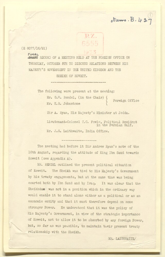
57. 'Final Record of a Meeting Held at the Foreign Office on Thursday October 5th [1933] to Discuss Relations between His Majesty's Government in the United Kingdom and the Sheikh of Koweit'
- Description:
- Abstract: This is a printed memorandum containing a record of a meeting held at the Foreign Office on 5 October 1933 to discuss relations between Great Britain and the Sheikh of Koweit [Kuwait], Aḥmad bin Jābir Āl Ṣabāḥ, particularly in regards to Ibn Saud [‘Abd al-‘Aziz bin ‘Abd al-Raḥmān Āl Sa‘ūd]. The following were present at the meeting: Mr George William Rendel (Chair), Eastern Department of the Foreign Office; Mr K R Johnston, Foreign Office; Sir Andrew Ryan, His Majesty's Minister at Jeddah; Lieutenant-Colonel Trenchard Craven William Fowle, Political Resident in the Persian Gulf; and Mr John Gilbert Laithwaite, India Office.The memorandum also includes two appendices: 'Appendix A. Note by Sir Andrew Ryan. Ibn Saud's attitude towards Kowait', dated 16 August 1933 (folios 14-17); and 'Appendix B. Provisional Note. Obligations of His Majesty's Government towards the Sheikh of Koweit', 11 October 1933, by Sir John Gilbert Laithwaite (folios 18-25), which includes sections entitled 'A. Nature of the undertakings given', 'B. Constitution of the undertakings given to the Sheikh', and 'Conclusion', with references to various correspondence in the right hand margin.Physical description: Foliation: The foliation sequence commences at the first folio, and terminates at the last folio; these numbers are written in pencil, are circled, and are located in the top right corner of the recto side of each folio.Pagination: The volume also contains an original printed pagination sequence.
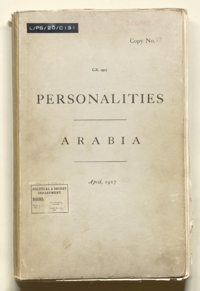
58. 'Personalities, Arabia'
- Description:
- Abstract: The volume is Personalities, Arabia(Admiralty War Staff Intelligence Division, April 1917).The volume is an official report on prominent Arab individuals and Arab tribes in the Arabian Peninsula and other parts of the Middle East. The volume contains personal, historical and genealogical information on ruling families, individual members of ruling families, and other prominent individuals (including commercial firms and merchants) within the regions numbered I-VII below; and ethnographic information on the Bedouin tribes and sedentary tribes (divided into four geographical groupings). The regions and groupings are as follows:I Hejaz (folios 4-13);II Asir (folios 13-23);III Yemen (folios 23-32);IV Aden and Hadhramaut (folios 33-37);V Gulf Coast (folios 37-43);VI Central Arabia (folios 44-50);VII Syrian Desert and Sinai (folios 51-53);The Bedouin Tribes (folios 53-76);Sedentary Tribes of The North-West (folios 77-80);Sedentary Tribes of The West (folios 81-125);Sedentary Tribes of The South (folios 125-165);Sedentary Tribes of The Centre (folios 166-169).The volume includes a 'Tribal Map of Arabia' on folio 184.Physical description: Foliation: the foliation sequence commences at 1 on the front cover and terminates at 186 on the last folio before the back cover. The numbers are written in pencil, are enclosed in a circle, and appear in the top right hand corner of the recto page of each folio. The following folio needs to be folded out to be examined: folio 184. This is the system used to determine the order of pages.Pagination: the volume also contains an original printed pagination, numbered 4-362 (folios 4-183).
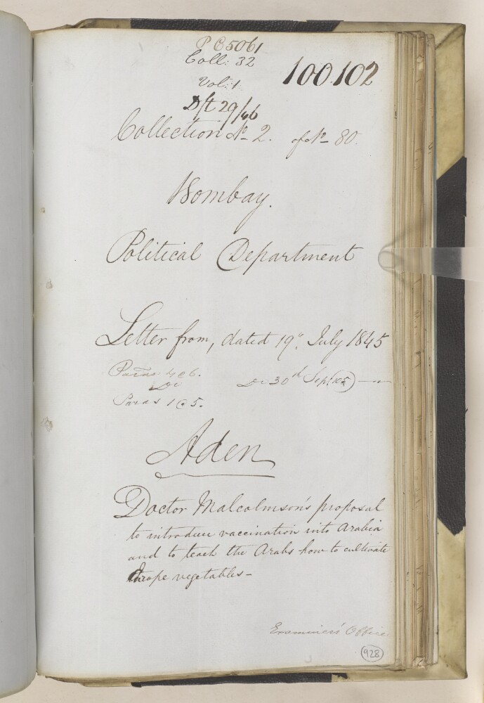
59. ‘Aden. Doctor Malcolmson’s proposal to introduce vaccination into Arabia and to teach the Arabs how to cultivate Europe vegetables’
- Description:
- Abstract: The item consists of copies and extracts of correspondence and minutes cited in, or enclosed with, two Political Letters from the Government of Bombay [Mumbai] to the East India Company Court of Directors, dated 19 July and 30 September 1845. Some of the enclosures mentioned in the second letter can be found at IOR/F/4/2122/100103.The item relates to requests to the Court of Directors made by Dr John Porter Malcolmson, Civil Surgeon at Aden. Malcolmson asks for permission to travel to Lahedge (also rendered as Lahidge [Lahij]) and into the interior of Arabia [Arabian Peninsula] in order to introduce vaccination into the general region and also teach ‘the Arabs’ how to cultivate European vegetables. The item contains the replies to Malcolmson's requests from: the Court of Directors; the Government of Bombay; and Malcolmson’s superior, Captain Stafford Bettesworth Haines, Captain in the Indian Navy and Political Agent at Aden. The item also includes a letter to Malcolmson from Charles Chantry, Secretary of the Royal Jennerian and London Vaccine Institution, dated 25 April 1845.The title page of the item contains the following references: ‘Bombay Political Department’, ‘P.C. [Previous Communication] 5061, Draft 29/46, Coll[ection]: 32, Vol: 1’, ‘Collection No. 2 of No. 80’ and ‘Examiner’s Office’.Physical description: Foliation: the foliation sequence for this description (used for referencing) commences at f 928, and terminates at f 938, as it is part of a larger physical volume; these numbers are written in pencil, are circled, and are located in the bottom right corner of the recto side of each folio.Pagination: the item also contains an original pagination sequence.
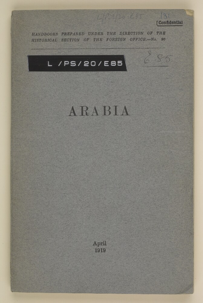
60. 'Arabia. Handbooks prepared under the direction of the Historical Section of the Foreign Office - no 90'
- Description:
- Abstract: This volume contains information on the geography, political history and economic conditions of Arabia and was published by the Historical Section of the Foreign Office in April 1919.It is divided into four sections: 'Geography Physical and Political'; 'Political History'; 'Political Conditions' and 'Economic Conditions'. There is an Appendix, containing tables regarding trade in Aden, Muscat and Bahrein, 1909-1917.There is a map 'Sketch Map of the Persian Gulf and Arabia', compiled by the War Office on June 1914.Physical description: Foliation: There is a foliation sequence, which is circled in pencil, in the top right corner of the recto of each folio. It begins on the first folio with text, on number 1, and ends on the map on a sleeve on the inside back cover, on number 70.Pagination: There is also an original pagination, iv-vi, 2-127.