1 - 3 of 3
Number of results to display per page
Search Results
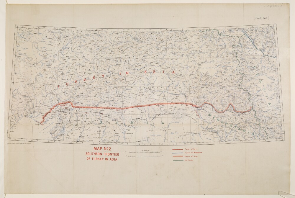
1. 'MAP NO.2: SOUTHERN FRONTIER OF TURKEY IN ASIA'
- Description:
- Abstract: This map shows Turkey where it is included in Asia and indicates the boundaries between Turkey, Syria, Mesopotamia and the Old Frontier. The map also indicates relief with contours.The map includes a printing statement which reads '(B 16479) WT 18378-212.5050.10/20.H&S,LTD.'Physical description: Materials: Printed in colour on paper with manuscript additions in coloured inkDimensions: 310x 733mm, on sheet 505 x 759mm
2. War Cabinet Papers Relating to Syria and the Sykes-Picot Agreement of 1916
- Description:
- Abstract: The file chiefly comprises correspondence, memoranda, and newspaper cuttings relating to the Sykes-Picot Agreement of 1916 and British policy in former Ottoman territories following the end of the First World War. Many of the papers were printed and prepared for the War Cabinet (from March 1918, the Eastern Committee of the War Cabinet) and date from May 1915 to September 1919.The papers cover several matters, including:Negotiations leading up to the Sykes-Picot Agreement (ratified in May 1916) and concerning the future government of Syria (including Lebanon), Palestine, Mesopotamia [Iraq], and Asiatic Turkey, and the securing of British and French 'rights' in the regionOther wartime agreements involving Britain, France, Russia, Italy, and Roumania [Romania]Revision of the Sykes-Picot Agreement in 1918 following subsequent developments during the War, in particular the 'Arab Revolt' [uprising of Arab nationalists against the Ottoman Empire] and the conquest of Palestine and Syria by British and Arab forcesThe discussion of an Anglo-French declaration to be made to try and appease the inhabitants of the regionThe British Government's response to a memorial issued by seven Arab leaders resident in Egypt regarding their desires for self-determination in the region, particularly SyriaA statement made by Feisal [Fayṣal bin Ḥusayn bin ‘Alī al-Hāshimī] to the Chief of General Staff, Egyptian Expeditionary Force, 31 August 1919, regarding recent events in the region, promises made to the Arabs during the War, and Arab determination to achieve independence.The correspondence is principally between diplomats and politicians of the British, French, Russian and Italian governments, and officials at the Foreign Office and War Office.Folios 70-84 consist of related manuscript notes by Lord Curzon.The French language material consists of correspondence from French diplomats and politicians.Physical description: Foliation: the foliation sequence (used for referencing) commences at the front cover with 1, and terminates at the inside back cover with 85; these numbers are written in pencil, are circled, and are located in the top right corner of the recto side of each folio.
3. Asiatic Turkey and Arabia
- Description:
- Abstract: The file consists of a series of conventions, agreements, and declarations concerning navigation on the Tigris and Euphrates rivers, the Turco-Persian boundary, and the transportation of goods by railway in Asiatic Turkey.It is divided into four sections and contains five maps: IOR/W/LPS/18/B381 (i-vi).The main body of the file is in French.Physical description: Foliation: the foliation sequence for this description (used for referencing) commences at f 82, and terminates at f 100, as it is part of a larger physical volume; these numbers are written in pencil, and are located in the top right corner of the recto side of each folio.A previous foliation sequence has been superseded and therefore crossed out.Pagination: the file also contains an original printed pagination sequence for each item.