« Previous |
1 - 12 of 20
|
Next »
Number of results to display per page
Search Results
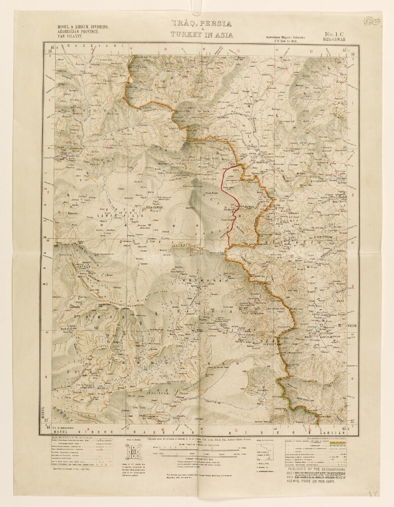
1. ‘Irāq, Persia & Turkey in Asia’
- Description:
- Abstract: Map numbered 1.C (Diza-Gawar [Diza Hawār]), and subtitled ‘Mosul & Kirkuk Divisions. Azarbāījān [Azerbaijan] Province. Van Vilayet.’ An index to the geographical location of the provinces is provided below the map. A caption under the map states that it was published under the direction of Colonel Charles Henry Dudley Ryder, Surveyor General of India, 1923. A stamp in the bottom right corner of the map states that it was published by the Geographical Section General Staff, War Office.The map indicates: relief, shown by contours and shading, with elevations given in feet; rivers, lakes, marshes; province and country boundaries; settlements, with place names in English; railways, roads and other transport routes. An additional boundary line, drawn in red ink, has been added to the map.The map is mentioned in a copy of a letter sent by HM’s Envoy Extraordinary and Minister Plenipotentiary at Tehran (Reginald Hervey Hoare) to the Secretary of State for Foreign Affairs (John Allsebrook Simon), dated 1 July 1932, which states that the ‘Turkish military attaché has been so good as to draw upon sheets 1 A, 1 B, and 1 C [...] the line of the new frontier’ (f 48).Physical description: Materials:1 paper folio.Dimensions:462 x 478 mm, on sheet 574 x 434 mm.
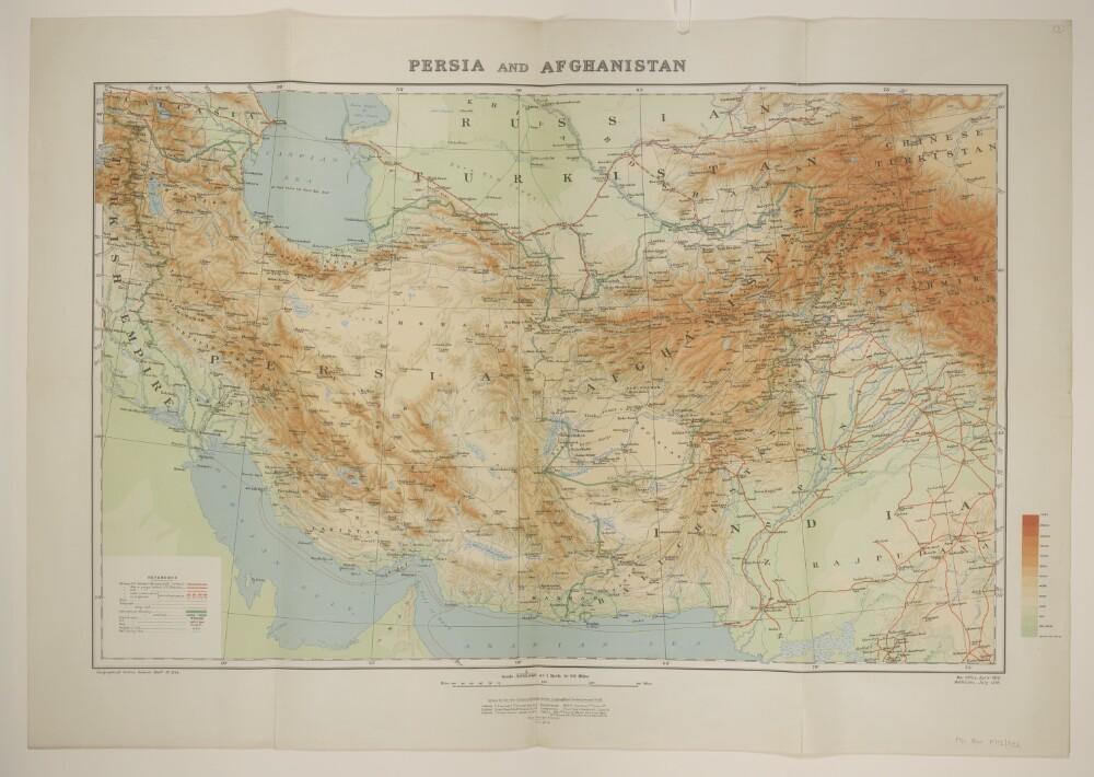
2. 'Persia and Afghanistan'
- Description:
- Abstract: Printed sheet bearing the series designation 'Geographical Section, General Staff No. 2149' and providing full country coverage of Persia [Iran] and Afghanistan with significant partial coverage of present-day Turkey, Armenia, Azerbaijan, Turkmenistan, Pakistan and Iraq. Portrays, hydrology, relief by spot heights, gradient tints and shading, railways, roads, telegraphs, settlements, water sources, place names, and international boundaries. The sheet bears the imprint 'War Office, April 1912. Additions, July 1916.'The verso bears the manuscript note 'Persia & Afghanistan'.Physical description: Materials: Printed in colourDimensions: 494 x 767mm, on sheet 628 x 888mm
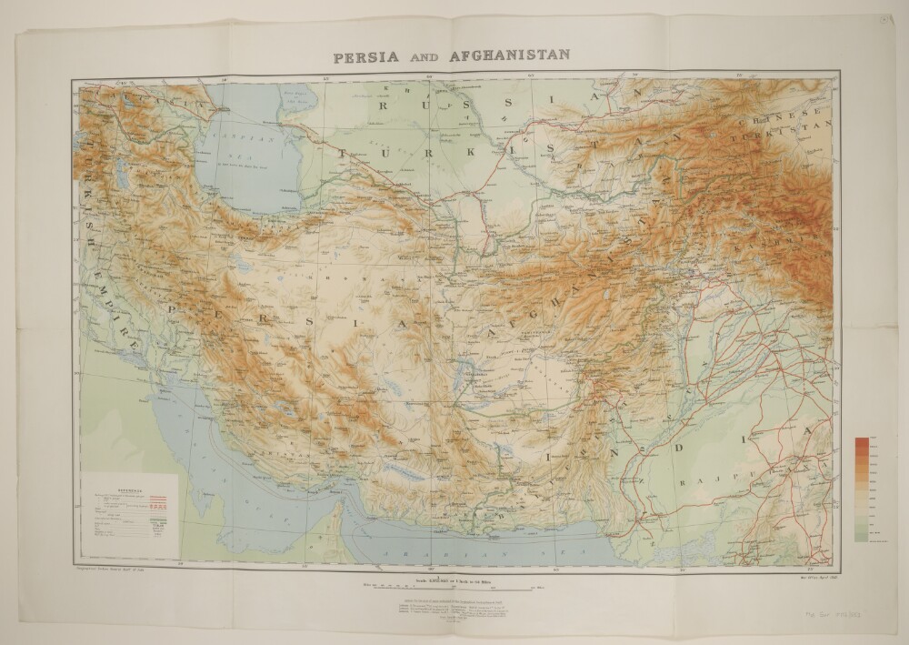
3. 'Persia and Afghanistan'
- Description:
- Abstract: Printed sheet bearing the series designation 'Geographical Section, General Staff No. 2149' and providing full country coverage of Persia [Iran] and Afghanistan with significant partial coverage of present-day Turkey, Armenia, Azerbaijan, Turkmenistan, Pakistan and Iraq. Portrays, hydrology, relief by spot heights, gradient tints and shading, railways, roads, telegraphs, settlements, water sources, place names, and international boundaries. The sheet bears the imprint 'War Office, April 1912.'The verso bears the manuscript note 'Persia and Afghanistan'.Physical description: Materials: Printed in colourDimensions: 494 x 767mm, on sheet 618 x 891mm
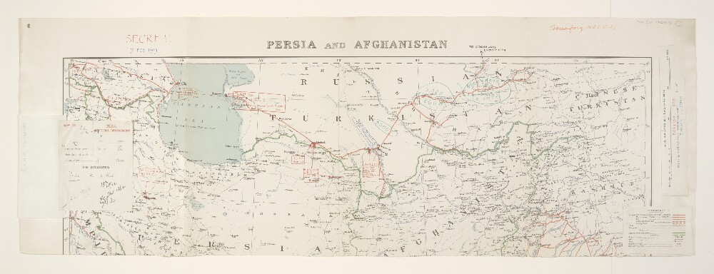
4. 'Persia and Afghanistan. 7. Feb. 1919.'
- Description:
- Abstract: Folio 1:Classified 'Secret'.The northern half of map sheet Geographical Section, General Staff No. 2149, complete sheets bearing the imprint 'April 1912, Additions July 1918, Railways revised Jan 1919'. Sheet portrays hydrology, relief by spot heights, roads, railways, telegraphs, settlements, place names, water sources and international boundaries. This version has been printed without coloured relief plates; copies with coloured relief plates are at Maps 50970.(27.) and Maps MOD GSGS 2149.Manuscript annotations provide details of British, Russ[ian]. and Turkoman Irregulars, and Enemy troops, a route objective, the date '7 Feb 1919', the classification 'Secret' and the note 'To accompany M[inistry].O[f].I[nformation]. J.24.' Annotated map detail covers Azerbaijan, Persia [Iran] and the Russian Soviet Federative Socialist Republic. A legend and scale bar, as would have appeared on the missing lower half of the map, have been pasted on. The verso bears the annotation 'Transcaspia'.Folio 1a:Classified'Secret'.Circulation list relating to Folio 1 above, to which it is attached. Printed in colour, with manuscript additions in ink. 137 x 153mm. Dated 1919-20.Physical description: Materials: Printed, with manuscript annotations in coloured ink and crayonDimensions: 262 x 764mm, on sheet 316 x 896mm
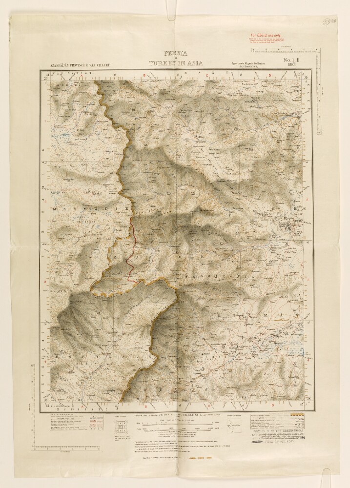
5. ‘Persia & Turkey in Asia’
- Description:
- Abstract: Map numbered 1.B (Khoī [Khoy]), and subtitled ‘Azarbāījān [Azerbaijan] Province & Van Vilayet.’ An index to the geographical location of the provinces is provided below the map. A caption under the map states that it was published under the direction of Colonel Charles Henry Dudley Ryder, Surveyor General of India, 1922. A stamp in the bottom right corner of the map states that it was published by the Geographical Section General Staff, War Office.The map indicates: relief, shown by contours and shading, with elevations given in feet; rivers, lakes, marshes; province and country boundaries; settlements, with place names in English; railways, roads and other transport routes. An additional boundary line, drawn in red ink, has been added to the map.The map is mentioned in a copy of a letter sent by HM’s Envoy Extraordinary and Minister Plenipotentiary at Tehran (Reginald Hervey Hoare) to the Secretary of State for Foreign Affairs (John Allsebrook Simon), dated 1 July 1932, which states that the ‘Turkish military attaché has been so good as to draw upon sheets 1 A, 1 B, and 1 C [...] the line of the new frontier’ (f 48).Physical description: Materials:1 paper folio.Dimensions:464 x 374 mm, on sheet 630 x 444 mm.
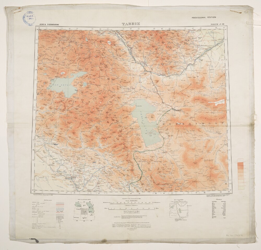
6. 'Tabriz'. With manuscript additions
- Description:
- Abstract: Geographical Section, General Staff No. 2555, sheet North J-38, Tabriz, Provisional Edition bearing the imprint 'Compiled at the Royal Geographical Society under the direction of the Geographical Section General Staff. Drawn and printed at the War Office. 1916.'Covers an area of up to 200 miles radius of Tabriz in north-western Persia [Iran], extending northwards into present-day Armenia and Azerbaijan. The printed map portrays hydrology, relief by contours and spot heights, railways, roads and tracks, settlements, telegraphs, post and telegraph offices, place names, and international and internal boundaries. A copy of this printed map is held at Maps MOD GSGS 2555; versions printed with gradient tints (see manuscript additions below) are held at Maps 46820.(185.) and Maps MOD GSGS 2555.Manuscript additions provide gradient tints, a route leading south from Tabriz and the underlining of a small number of settlements.The map bears the accession stamp, recto and verso, of the Director of Military Intelligence, War Office, 7 April 1920.Physical description: Materials: Printed in colour, with manuscript additions in coloured ink, watercolour and crayon, on paper (backed with linen)Dimensions: 445 x 540mm, on sheet 663 x 683mm
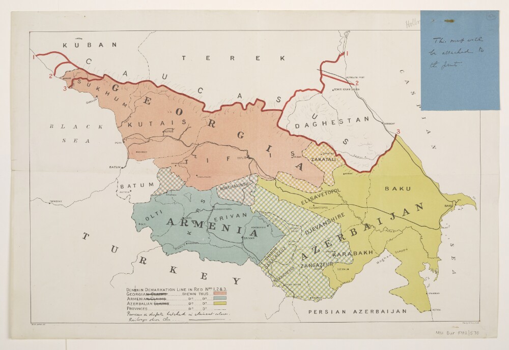
7. 'Caucasus Boundaries'
- Description:
- Abstract: Title taken from manuscript annotation on verso; recto bears no title.Printed sheet depicting disputed territories in the Caucasus, particularly Armenia, Azerbaijan, Georgia and southern Russia. Portrays hydrology, railways, settlements, place names, and international and internal boundaries; also depicts areas under dispute and three successive positions of the 'Denekin Demarkation Line'.The sheet bears the imprints '9172.28700.135.' and 'Malby & Sons, Lith.'Manuscript additions portray relief by hachures, amendment to the spelling of 'Denekin' to the more standard 'Denikin', and revision to the wording in the key.An attached folio (f 40a. Manuscript: ink on paper; 104 x 81mm) bears the note 'This map will be attached to the [?]print.'Physical description: Materials: Printed in colour, with manuscript additions in ink and pencilDimensions: 306 x 470mm, on sheet 345 x 510mm
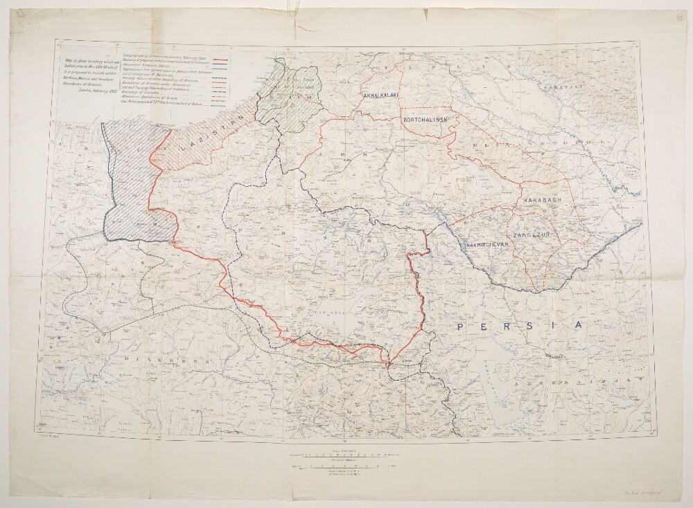
8. 'Map to show territory which was Turkish prior to War 1914-'18 which it is proposed to include within Northern, Western and Southern Boundaries of Armenia.'
- Description:
- Abstract: Created by the War Office, 1920. The sheet bears the series designation 'G[eographical].S[ection].G[eneral].S[taff]. No. 2944', and covers a 300 mile by 500 mile area of eastern Turkey under consideration for ceding to Armenia in the aftermath of the First World War. Also includes parts of present-day Azerbaijan, Georgia, Iran, Iraq and Russia. Portrays, hydrology, relief by contours and spot heights, railways, settlements, place names, and ten categories of existing and proposed internal and international boundaries.The verso bears the manuscript note 'Armenia'.Physical description: Materials: Printed in colourDimensions: 557 x 890mm, on sheet 712 x 980mm
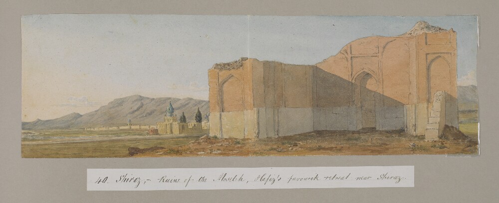
9. ‘Colonel D’arcy Drawings Made During the Embassy to Persia 1810–12’ by Joseph D’Arcy (1780–1846)
- Description:
- Abstract: Genre/Subject Matter:The album contains fifty-eight watercolour landscape views of locations visited during the Ouseley embassy to Persia, 1810–12, as well as two handlists, probably created by later owner F. G. McCutcheon c.1880, two notes from The Graphicmagazine to McCutcheon and a newspaper clipping from The Graphic, 1880.The watercolour drawings are on paper lightly tipped into the album. Titles and annotations made at a later date are pasted below the drawings and were probably written by McCutcheon. Titles on the versos of each drawing – where extant – are perhaps by D’Arcy himself, although they are also occasionally supplemented with further inscriptions, probably by McCutcheon.The drawings, numbered separately, have been mounted haphazardly and do not follow the route of the embassy. No. 15 is missing.The Ouseley embassy was a diplomatic mission during 1810-12 by Sir Gore Ouseley, Ambassador Extraordinary and Plenipotentiary to the Qajar court, to Fatḥ-ʿAlī Shah, which the British intended to use as an opportunity to collection intelligence about Iran while concluding the Anglo-Iranian Treaty of 1812.Elements:i) Handwritten ‘List of Water-Colour Drawings sketches in Persia by the late Lieut-Colonel D’Arcy. R. A. [Royal Academy] K.L.S. [Knight of the Lion and Sun of Persia] 1811–1812’, probably by F. G. McCutcheon, c. 1880, later owner of the album.1) ‘A ruined bridge near Mount Ararat, on the road to Constantinople’2) ‘Mount Ararat’3) ‘Greater & Lesser Ararat - Twilight’4) ‘Eklid [Iqlid], a Persian village’5) ‘Sion near Casibec – Caucasus’.[This drawing, outside the area of the Ouseley embassy and associated expeditions, may have been made when D’Arcy returned to England via Russia in 1815]6) ‘Scene in the mountains of Caraghehdaugh [Karadagh], Persia, where there is an Iron mine, Octr. 1812’.7) ‘Mount Sevilan [Savalan Dagh], 12,000 ft. high in Azerbijan’8) ‘Mount Sevilan [Savalan Dagh]. Even. Gt. storm coming’9) ‘Scene on the top of Mount Sevilan near the Crater’10) ‘View of the Ark from the Prince’s new garden, Tabreez, Figure is myself visiting the first Potatoe plants’11) ‘Tabreez, morning, from the suburbs’ and ‘will call for the sketch’ [This drawing was reproduced in The Graphic, 13 November 1880. A copy is pasted at the back of the album.]12) ‘The back of the Ark and walls of Tabreez, the view is taken from the back of Hadjir Khan Mohammed’s Garden’13) ‘Kizil Uzen [Qizil Uzun]River’14) ‘The Kuflan Kow [Ghafilan Kuh] Bridge over the Kizil Osan [Qizil Uzun] or River of Golden Fish that separates Media from Persia. Col D’Arcy’. In another hand: ‘Kafilan - Kow Bridge’.15) [MISSING]16) Bridge, possibly over the Qizil Uzun near Haji Hamseh17) Large lake and distant mountains, possibly Lake Urumieh.18) ‘Prince Royal’s Camp, Sulstan Sissar [sic]. 12 Oct. 1812’, repeated in another hand.19) ‘Romantic Scenery near the Camp at Sultan Hissar – Oct. 1812’, repeated in another hand.20) ‘Persia, Wild scene about 5 miles to the N. of the Prince’s Camp at Sultan Hissar in Sept. & Oct. 1812, the high ridge in the centre of the picture is called the Lasllect Moyeran, in July 1814 I went there to see if a Fortress could be built on it. J.D’A’.21) ‘Amit Begloo [Dost‘Ali Begli]. Evg. 15 Oct. 1812’.22) Recto: ‘Camp near Amet Begloo [Dost‘Ali Begli]. Augst. 1812’. Verso: ‘From the camp at Ahmet Begloo’.23) Borazjun, on the route to Shiraz.24) ‘Berazgoon [Borazjun]’25) ‘The pass of Tangi Tourkon [Tang-i Turkhan] – halfway to Firoozabad’, repeated on original mount with ‘Farsistan’.26) ‘Entering the Kotils from Bushire’ [Note: Kotil or Kutal, a general word for high mountain pass]27) ‘The Camp at Dalkie [Daliki] on the Road from Bushire to Shiraz’28) ‘Abou-Shehr or Bushire, Persian Gulf’ / ‘On the road to Dalkin [Daliki] from Bushire showing the mirage’29) ‘Scene entering the Kotils from Bushire’.30) Recto: ‘Kotil Dokhtor [Kutal Dukhtar]’. Verso: ‘Kotil Dochter’ [Note: See Ouseley, vol. I, pl.XX.31) ‘View of the Salt Lake near Shiraz – seen from a valley beyond the Madrij Solimaun [Masjed Soleymān]’32) ‘View from the back of the Takhti Kadjar – Shiraz – Evening. The outlines of this view were hastily sketched in – on the last evening of our being there and the details put in since from other sketches and memory’33) ‘The Dariagh Namak – or Salt Lake – seen from the back of the Madre Solimaun [Masjed Soleymān]’34) ‘The rahdarri – or Toll station near Shiraz at the foot of the Madre i Soliman [Masjed Soleymān] – Salt Lake in the distance’35) ‘Scene just beyond the Shutur Khorah - shewing the Madre i Soliman [Masjed Soleymān], Salt Lake and pou i fassa, Shiraz’.36) ‘Ruins of the Shutur Khorah, or Camel stables near the gate of the Dilgusha, Shiraz’37) ‘View from the west of the Takht i Kajar, Shiraz looking towards the Salt Lake, April 1811’.38) ‘Shiraz, seen from the ground near the Moselleh [South]’39) ‘Diwan Khaneh or Hall of Audience of the Prince Royal at Shiraz, May 1811’.40) ‘Ruins of the Moseleh (Hafiz’s favourite retreat) near Shiraz, Persia’41) ‘The Hafiziah or Tomb of Hafiz – Shiraz’.42) ‘The Kou-i-barf (snow mountain) 5 miles N.W. of Shiraz, morning’. Also drawing of a bearded man.43) Mountain view with travellers and horses.44) A garden pavilion, Kulah-i Ferangi, Shiraz.45) Stony plain with toll gate and mountain ridge in the distance.45a) Distant view of Isfahan with a road, river and irrigation channel in the foreground. A fortified building to the right.46) ‘Kou-i-barf, hill of snow. A remarkable mountain near Shiraz’.47) ‘The approach to Comisheh [Qumisheh], one stage from Ispahan 1811’48).‘Comisheh [Qumisheh] on the road from Shiraz to Ispahan’.49) Distant view of the ruins of Persepolis from across the Kur, or Bandamir, river. [Note: Some members of the embassy visited Persepolis from 26 April to 7 May 1811, and the entire party reached it by 13 July of the same year.]49a) ‘Ruins of Persepolis viewed by twilight’ [Note: On reverse notes and drawing of a man studying inscriptions on a ruined pillar]50) ‘Ruins of Persepolis or Takhta Ghemshid [Takht-i Jamshrid] also Chehel Minar, Persia’.51) ‘A Pigeon Tower at an angle of the Hazar jereeb near Isphahan, the hermitage and Kuh-i-Sufeh in the distance’.52) ‘Entrance to Isphahan’53) Tombs of the Kings of Persia at Qum.54) ‘Bridge of Alli Verdi Khan [‘Ali Vardi Khan]. Isphahan’55) ‘The Bridge of Khajoo over the Zienderoode Ispahan’56) ‘The City of Ispahan from the Camp ground on the North’57) ‘The Shah’s palace to the N. of Tehran’58) ‘The Palace within the walls’ii) Handwritten ‘List of Sketches (Persia), probably by F. G. McCutcheon, c. 1880, later owner of the album.iii) Note from editor of The Graphicto F. C. McCutcheon, owner of the album, 18 October 1880.iv) Cutting from The Graphic, 13 November 1880, showing the reproduction of the sketch ‘Tabreez’ (11).v) Note from manager of The Graphicto F. C. McCutcheon, owner of the album, 21 December 1880Inscriptions:Spine, gold embossed: ‘D’ARCY ALBUM’ ‘WD 1348’Page one, ink: ‘COLONEL D’ARCY DRAWINGS MADE DURING THE EMBASSY TO PERSIA 1810–12’Physical description: Dimensions:Album: 518 x 642 x 63 mmFormat:Navy leather album with gold fleur-de-lys embossing containing fifty-eight watercolour drawings and other handwritten or printed paper items lightly tipped onto card pages.Materials:Ink, watercolour and body colour.Condition:The binding is in excellent condition while the individual drawings, while delicate, are in the main well secured in the album. Surface dirt throughout all drawings, with some minor additional staining.Foliation:The images have been numbered 1–58 in ink captions affixed beneath each image as well as in the lower right corner of each image, in pencil. Pages are foliated throughout in the upper right corner.Technique:Watercolour sketches.Binding:The album is bound in navy leather format with gold fleur-de-lys embossing. A gilt stamp has been applied to the spine upon acquisition to the India Office Library.
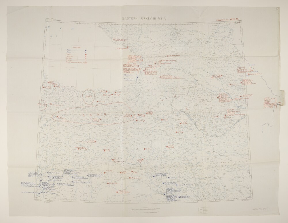
10. 'Eastern Turkey in Asia. Situation on 17.5.20.'
- Description:
- Abstract: Geographical Section, General Staff No. 2931, sheet 'Eastern Turkey in Asia', comprising a base map with overprints.The base map bears the imprint 'War Office, October, 1919' and portrays hydrology, relief by spot heights, railways, settlements, place names, and internal and international boundaries.A blue overprint depicts the position of British and French troops as at 17 May 1920; a red overprint depicts the position of Turkish, Azeri, Georgian and Armenian troops, and Turkish Nationalist Bands. The overprints extend approximately a hundred miles beyond the eastern neatline to Baku, Azerbaijan.Physical description: Materials: Printed in colourDimensions: 594 x 860mm, on sheet 712 x 930mm
11. Coll 28/112B Persia. Tabriz. Monthly dispatches of internal situation in Azerbaijan, & misc: reports.’
- Description:
- Abstract: Monthly reports submitted by the British Consul General at Tabriz, concerning events in Tabriz and Azerbaijan. The reports, which span the period January 1946 to January 1948, cover: the withdrawal of Soviet troops from Azerbaijan following the Anglo-Soviet occupation of Iran during the Second World War; the short-lived existence of the Azerbaijan People’s Government, declared in November 1945; the activities of the Democratic Party of Azerbaijan and its leader Ja’far Pishevari; the Iranian Government’s reassertion of control in Azerbaijan in 1947. The reports include sections describing: the general situation (with a detailed chronology of events given for reports covering January 1947 to May 1947); the activities of the Democratic Party of Azerbaijan; military operations; internal security; trade and industry; finance; communications; agriculture; Kurdish affairs; Armenian affairs; British, Soviet and American [USA] interests, including propaganda. The file includes an English translation of an agreement between representatives of the Government of Iran and the Azerbaijan People’s Government, the original of which was published in the newspaper Azerbaijanon 16 June 1946 (ff 165-167).The file includes a divider, which gives a list of correspondence references contained in the file by year. This is placed at the back of the correspondence.Physical description: Foliation: the foliation sequence (used for referencing) commences at the front cover with 1, and terminates at the inside back cover with 225; these numbers are written in pencil, are circled, and are located in the top right corner of the recto side of each folio.
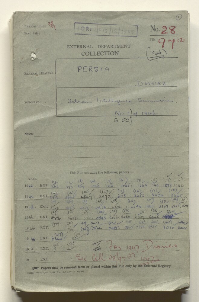
12. Coll 28/97(2) ‘Persia; Diaries. Tehran Intelligence summaries. No 1 to 50 of 1946.’
- Description:
- Abstract: Typewritten and printed copies of weekly intelligence summaries, submitted by the Military Attaché at the British Embassy in Tehran. The reports cover: the affairs and activities of the Persian [Iranian] Government and the majlis, including statements, communiqués and declarations made by the Persian Prime Minister, Qawam us-Saltaneh [Qavām os-Saltaneh]; internal security in Iran and its various provinces, with a particular focus on the political unrest in Azerbaijan, in the wake of the Soviet army’s refusal to withdraw from Azerbaijan, and pro-Soviet sentiment in the region; Persian government appointments; the Persian army; reports in the Persian press, with a particular focus on the expression of anti-British sentiment in some publications; foreign interests in Persia, chiefly relating to Britain, the Soviet Union, and the United States of America; notes on prominent Persian personalities.Physical description: Foliation: the foliation sequence (used for referencing) commences at the front cover with 1, and terminates at the inside back cover with 146; these numbers are written in pencil, are circled, and are located in the top right corner of the recto side of each folio.
- « Previous
- Next »
- 1 Current Page, Page 1
- 2