1 - 6 of 6
Number of results to display per page
Search Results
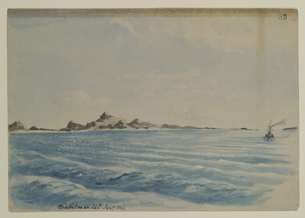
1. 'Babelmandel', by Sir Henry Yule (1820-1899)
- Description:
- Abstract: Genre/Subject Matter:Maritime view in the straits of Babelmandel [Bab-el-Mandeb]. A steamer is visible at left.Temporal context:This drawing was likely made during Henry Yule’s return journey to India with his new wife, Anna Maria White, in 1844.Inscriptions:Recto:Lower left, pen and ink: ‘Babelmandel Jany 1844’Upper right, ink stamp: ‘35’Verso:Centre, ink stamp: ‘India Office Library 12 Dec 1919’Upper right, pencil: ‘36’Physical description: Dimensions:177 x 254 mmMaterials:Watercolour and pen on watercolour paperCondition:Thick surface dirt throughout and on recto with staining originating from adhesive on upper edge.
2. Princess Charlotte: Journal
- Description:
- Abstract: Journal of the voyage of the Princess Charlottefrom England to Madras, Bengal, Bombay, and Mocha, and back (Captain Charles Elton Prescott), 6 January 1798-5 November 1800: left Portsmouth, 24 March 1798; 30 May 1798, Cape of Good Hope; 18 August 1798, Madras; 26 September 1798, Calcutta; 14 December 1798, Sauger [Saugor]; 31 January 1799, Goa; 19 February 1799, Bombay; 1 May 1799, Mocha; 7 May 1799, Babelmandel [Bab el Mandeb]; 2 June 1799, Mocha; 16 June 1799, Babelmandel; 31 July 1799, Mocha; 18 September 1799, Bombay; 25 November 1799, Diamond Harbour; 5 January 1800, Saugor; 25 April 1800, Cape of Good Hope; 7 June 1800, St Helena; 23 September 1800, Downs.The ship was at Mocha (three times) and Bab el Mandeb (twice) from 1 May to 25 August 1799.Inscribed: 'This is my original Journal, C Elton Prescott' (folio 1).Marked 'Received 1 October 1800' (folio 1), relating to folios 1-177 (to 27 September 1800), and '2 Sheets Reced 10 Novr. 1800' (folio 178), relating to folios 178-181 (28 September-5 November 1800).The Journal contains daily entries in six columns: H [Hour], Courses, K [Knots], F [Fathoms], Winds etc., and Remarks (with a column also for courses and bearings for parts of the voyage). When the ship is at anchor, the entries consist of remarks only ('harbour logs'). The Journal records navigational information; weather; contact with other East India Company ships as part of a fleet, and in harbour; contact with country ships; contact with His Majesty's ships, in convoy and elsewhere; sightings of other vessels, punishments inflicted on crewmembers and soldiers; the cleaning and maintenance of the ship; the provisioning of the ship, a birth at sea; deaths at sea; the delivery of the Company's cargo; private trade; and general remarks.The Journal also includes the following supplementary papers: list of officers and seamen etc. on board the Princess Charlotte, giving number, date when entered, names, stations, and date dead, run or discharged (folios 2-3); Journal entry for 21 November 1799 (folio 4); list of officers, soldiers, women, etc. embarked by order of Rear Admiral Rainier from the ship Thetison board the Honourable Company's armed ship Princess Charlotteat sea, 8 February 1799, and disembarked at Bombay, 20 February 1799, giving numbers, and names and rank etc. (folios 6-7); list of officers, non-commissioned officers, and privates, of HM 84th Regiment of Foot, embarked aboard the Princess Charlotteat Bombay, 2 April 1799, and disembarked at Babelmandel [Bab el Mandeb] Island, 8 May 1799, giving number, and names and rank etc. (folio 7); list of the Honourable Company's Artillery embarked on board the Princess Charlotteat Bombay, 2 April 1799, and disembarked 9 May 1799 at Babelmandel Island, giving number, and names and rank etc. (folios 7-8); list of passengers from England for India, giving number, date embarked, names etc., and date disembarked (folio 10); list of the Honourable Company's Artillery passengers for Bengal (including women and children), giving number, date embarked, names, and date disembarked (folio 10); list of detachment of His Majesty's 12th Regiment of Foot, passengers for Madras, giving number, date embarked, names etc., and date disembarked (folios 10-11); list of detachment of HM troops, passengers for Madras, received on board at Simeon's Bay [Simon's Town], Cape of Good Hope, giving number, date embarked, names etc., and date disembarked (folio 11); and list of passengers from Bengal homeward bound, embarked 23 January 1800, went on shore at Dover, 23 September 1800 (folio 11).The record is part of a volume containing four separate log books: Princess Charlotte: Journal, 1796-97 (IOR/L/MAR/B/245A); Princess Charlotte: Journal, 1798-1800 (IOR/L/MAR/B/245B); Princess Charlotte: Journal, 1801-03 (IOR/L/MAR/B/245C); Princess Charlotte: Deck Log, 1819-20 (IOR/L/MAR/B/245D).Physical description: Foliation: the foliation sequence for this description (used for referencing) commences at f 1, and terminates at f 181; it is part of a larger physical volume of different shelfmarks in which every shelfmark has been given its own separate foliation sequence, i.e. non-consecutive; these numbers are written in pencil, are circled, and are located in the top right corner of the recto side of each folio.
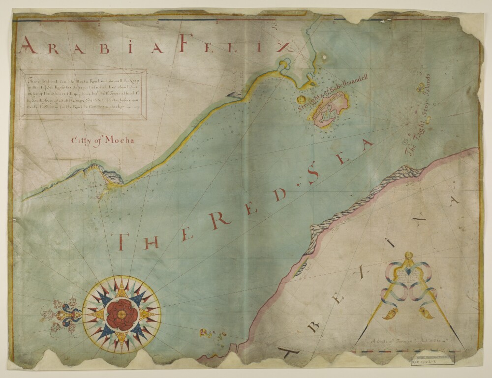
3. Chart of the Strait of Babellmandell made by John Friend Against ye East India hous in leaden hall Street London An.o Dn.o 1714
- Description:
- Abstract: Distinctive Features:Hand drawn nautical chart of the Strait of Babellmandell [Bab-el-Mandeb] at the south entrance into the Red Sea drawn by John Friend in 1714 to “A Scale of Twentey English Miles”.Relief shown pictorially. Depths shown by soundings with reefs and shoals represented by crosses; positions for safe anchorage indicated.Shows a central compass rose orienting east to the top of the map.Includes a textual description of the Citty of Mocha with remarks on sailing directions.MS annotation in ‘A Catalogue of Manuscript and Printed Reports, Field Books, Memoirs, Maps, etc., of the Indian Surveys, Deposited in the Map Room of the India Office’ published in 1878: ‘The chart is supposed to have belonged to Phillip Herbert Commander of the Euphrates, R. 1404/25’.Inscriptions:On verso in the upper left in red ink: ‘R. 1404/25’ and below in black ink: ‘India Office: Map Drawer U.VI – folio 3’.Physical description: Materials:Pen and ink with colour highlighting on parchmentDimensions:660 x 872 mm
4. Drawings of the coast around Aden and along the Red Sea made during Elwon’s survey to establish the best course for steamers travelling to and from Suez by Thomas Elwon (1793/4-1835)
- Description:
- Abstract: Genre/Subject Matter:A series of coastal profiles in pencil record the survey of the Red Sea undertaken by Captain Thomas Elwon of the Benaresthat took place between 1829-1834 to establish the best course for steamers to and from Suez.Taken from a sketch book inscribed on the first page ‘Capt Elwon’, these topographical views probably record the southern section of the coastline from Jeddah to Bab-el-Mandeb.Although some are quite detailed line drawings, none are fully worked watercolour drawings.Inscriptions:Inscribed in pencil throughout.Physical description: Dimensions:Variable.Materials:Pencil on paper.Condition:Many are damaged sheets; all have been stabilised through conservation.
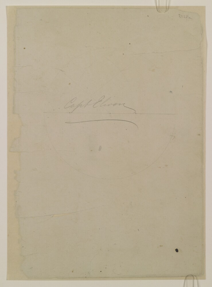
5. Six views of the Red Sea coastline and flysheet of a sketchbook by Thomas Elwon (1793/4–1835)
- Description:
- Abstract: Genre/Subject Matter:These six topographical views of the coastline, probably along the strait of Babelmandel [Bab-el-Mandeb], are sketched from on board ship.On the recto of WD3528, two detailed views indicate settlements, boats at anchor, fortifications, lighthouses and other structures as well as the rocky hills that line the coastline. Location cannot be determined due to damage to the support at the point where an inscription was intended to identify the place. However, it is likely that these views were sketched in the vicinity of those on the verso.On the verso of WD3528 four further, less detailed views predominantly indicate geographic features along the coastline. Inscriptions indicate locations as follows: Babelmandel Island [Barīm]; Fisher or Pilots Island Island [Fisherman’s Rock or Pilot’s Rock / Shaykh Malu Island]; Babelmandel Cape [Ras Bab el Mandeb]; Babelmandel Quoin [a wedge-shaped point on Ras Bab el Mandeb].Due to extensive damage to the paper and despite subsequent repairs, much of the information on both recto and verso is rendered unusable or illegible. In the centre of the lower view on the recto, a later hand has redrawn sections of the missing image in pencil in a clumsy attempt to restore the image.On the recto of WD3528a, which was the flysheet of a sketchbook comprising the drawings WD3528–WD3536, the name ‘Capt Elwon’ has been inscribed, indicating that the sketchbook belonged to Elwon.Inscriptions:WD3528 Recto:Below lower view, in pencil: ‘Sketch of Cape [lost] Town’WD3528 Verso:Upper left corner, in pencil: ‘WD3528’Upper view, in pencil: ‘Part of Penin. or Babelmandel Island [Barīm], Ship steering West entrance of the Arab [illegible] aheads’Upper middle view, in pencil: ‘Fisher or Pilots Island [Fisherman’s Rock or Pilot’s Rock / Shaykh Malu Island]off Babelmandel Cape [Ras Bab el Mandeb]’Lower middle view, in pencil: ‘Babelmandel Quoin [Ras Bab el Mandeb]’WD3528a Recto:Centre of page, in pencil: ‘Capt Elwon’Upper right corner, in pencil: ‘3528a’Physical description: Dimensions:204 x 307 mmMaterials:Pencil on paperCondition:Heavy surface dirt coats the recto and verso of WD3528, especially at edges. The paper is heavily cracked and torn throughout, with large portions of the page missing, however, repair work has stabilised the sheet. WD3528a has also been stabilised and is in good condition.
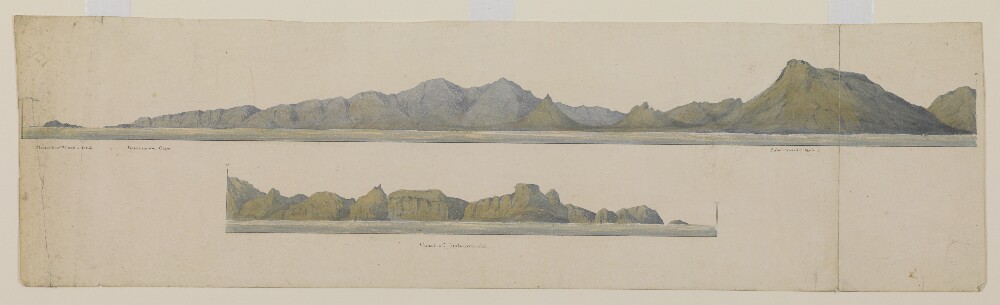
6. Two views of the coast of Babelmandel Cape [Ras Bab-el-Mandeb] by Thomas Elwon (1793/4–1835)
- Description:
- Abstract: Genre/Subject Matter:These two sequential topographical views of Babelmandel Cape [Ras Bab-el-Mandeb], sketched from on board ship.The area shown is a fully worked view based on the sketches found in WD3528 and show the following features of the coastline, from left to right: Fisher’s or Pilot’s Island [Fisherman’s Rock or Pilot’s Rock / Shaykh Malu Island]; Babelmandel Cape [Ras Bab el Mandeb]; Babelmandel Quoin [a wedge-shaped point on Ras Bab el Mandeb]; Coast of Babelmandel [Ras Bab-el-Mandeb].Inscriptions:Recto:From left to right, below image, in pen: ‘Fisher’s or Pilot’s Island’; ‘Babelmandel Cape’; ‘Babelmandel Quoin’; ‘Coast of Babelmandel’.Far right and lower left, in pen: ‘a’Physical description: Dimensions:148 x 530 mmMaterials:Watercolour and pen on paperCondition:Surface dirt coats the recto and verso, particularly at left edge where staining is also visible.. The paper is extensively cracked along right-hand fold and left-hand edge, however, repair work has stabilised the sheet.