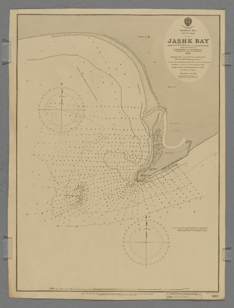
Abstract: Chart 2862.Hydrographic chart covering the eastern half of Jashk Bay [Khalij-e Jask], Cape Jashk [Damagheh-ye Jashk] and Mason Shoal, Persia [Iran] in the Gulf of Oman. Portrays hydrology, including depths by soundings and contours, sands and rocks, anchorages, relief by spot heights, hachures and shading, vegetation, cultivation, settlements, public buildings, telegraph offices, forts and place names, and includes topographical notes and navigational aids, including beacons, and prominent landmarks.Surveyed by Lieutenant Charles James Cope Kendall, Royal Indian Marine, 1896. Engraved by Edward Weller. Published at the Admiralty, 1897.Physical description: Materials: Printed on paperDimensions: 628 x 457mm, on sheet 658 x 494mm
Abstract: Genre/Subject Matter:General view of the British Telegraph Station at Jask. Typical of British Colonial architecture, the installation consists of at least five two-storey structures featuring round arches.The foreground and middle-ground is made up of a stoney plain with little vegetation.Inscriptions:Upper right, in pencil alongside image: 'b', '41'Below image, in pen: 'Telegraph Station, Jask'Physical description: Dimensions:124 x 205 mmFormat:Albumen print on paperCondition:The print is in good condition with staining and light creasing in the sky area in the upper left and right corners and minor surface dirt throughout. Inscriptions on the verso are faintly visible on the recto.Foliation:‘b’ (crossed out); ‘41’Process:Albumen print
Abstract: Genre/Subject Matter:General view of the British Telegraph Station at Jask. Typical of British Colonial architecture, the installation consists of at least five two-storey structures featuring round arches.The foreground and middle-ground is made up of a stoney plain with little vegetation.Inscriptions:Upper right, in pencil alongside image: 'b', '41'Below image, in pen: 'Telegraph Station, Jask'Physical description: Dimensions:124 x 205 mmFormat:Albumen print on paperCondition:The print is in good condition with staining and light creasing in the sky area in the upper left and right corners and minor surface dirt throughout. Inscriptions on the verso are faintly visible on the recto.Foliation:‘b’ (crossed out); ‘41’Process:Albumen print
Abstract: The map shows a British cable station at Cape Jashk on the coast of south-eastern Persia, indicating principal buildings, wells, water tanks, the routes of a land telegraph and undersea cables, hydrology and topography.The map is Plate 1 in 'Persian Gulf and Gulf of Oman' (Naval Intelligence Department No. 694), 1903, and was compiled 'From a sketch made by Commander Thomas Webster Kemp, Royal Navy, Jan. 1903.'.A printing statement reads, 'Weller & Graham, Ltd. Litho, London.'.Physical description: Materials: Printed on paperDimensions: 183 x 306mm, on sheet 244 x 477mm

_0001.jp2/full/!1000,1000/0/default.jpg)
