Abstract: Enclosure nos. 2-14 to a despatch from the Secret Department, Government of Bombay [Mumbai], dated 29 November 1841. The enclosures are dated 13 August-29 November 1841. The enclosures consist of copies of correspondence relating to continuing surveys by steam boat of the River Euphrates to determine its navigability, particularly their financing and accounts. The correspondents are Lieutenant Henry Blosse Lynch, Commander of the Surveys, and the Government of India.Physical description: 1 item (24 folios)
Abstract: Enclosure nos. 2-10 to a despatch from the Secret Department, Government of Bombay [Mumbai], dated 30 December 1841. The enclosures are dated 25 March-30 December 1841. The enclosures consist of copies of correspondence relating to continuing surveys by steam boat of the River Euphrates to determine its navigability, particularly their financing and accounts, and the state of repair of the steam vessels
Euphratesand
Nimrod. The correspondents are: Lieutenant Charles Dugald Campbell, commanding the surveys during the absence of Lieutenant Henry Blosse Lynch; the Superintendent of the Indian Navy; and the Government of India.Physical description: 1 item (24 folios)
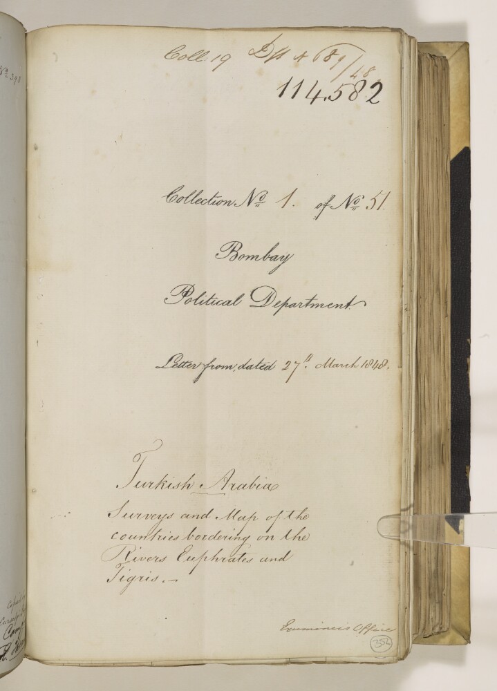
Abstract: This item consists of copies of correspondence, consultations, memoranda, and minutes, cited in, or enclosed with, political letters from the Government of Bombay. The correspondents are: the Government of Bombay; Major Henry Rawlinson, Political Agent in Turkish Arabia [Ottoman Iraq]; Lieutenant-Colonel Commandant Chief Engineer George Jervis; Captain Sir Robert Oliver, Superintendent of the Indian Navy; Captain Henry Blosse Lynch; and the Government of India.The item concerns the surveys of the Euphrates, Tigris, and Kuran [Karun] rivers, and the process of Captain Felix Jones creating a new chart from the results of Lynch’s survey expeditions. The item includes details of the employment of draughtsmen, the creation of copies, and lists of surveys, but it does not contain copies of the maps or surveys themselves.The item contains a contents page and the title page of the item contains the following references: ‘Draft no 689/48’, ‘Coll[ection]: 19’, ‘Collection No 1 of No 51’.Physical description: Foliation: the foliation sequence (used for referencing) commences at the first folio with f 352, and terminates at f 382 as it is part of a larger physical volume; these numbers are written in pencil, are circled, and are located in the bottom right corner of the recto side of each folio.Pagination: the item also contains an original pagination sequence.
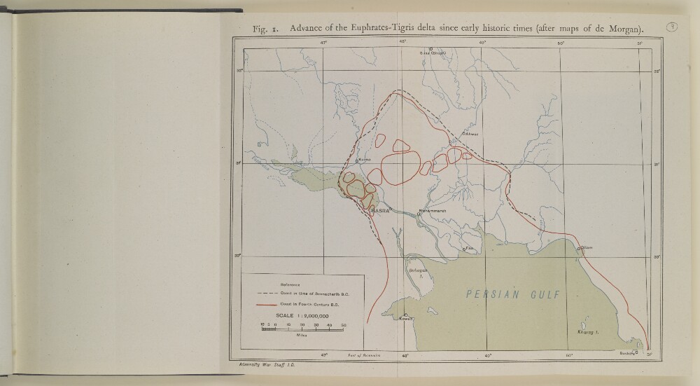
Abstract: Distinctive Features:Map of the Tigris-Euphrates Delta produced to illustrate the geology of Mesopotamia and surrounding region based on Jacques de Morgan’s research. Shows the advance of delta over the time with the Persian Gulf’s coast in time of Sennacherib B.C. by pecked line; the coastline in fourth century indicated by red line.Bottom left-hand corner below neat line: ‘Admiralty War Staff I.D.’.Physical description: Dimensions:193 x 257 mm
Abstract: The volume contains copies of incoming and outgoing correspondence for the Persian Gulf Residency. At the start of 1852 Lieutenant-Colonel Samuel Hennell is Resident, before being superseded by Captain Arnold Kemball. Correspondence in the volume falls under the following headings:Persia, Basra and Baghdad (folios 2-4);The Persian Gulf slave trade (folios 6-8);Correspondence with the Muscat Political Agent (folios 10-23);Commerce (folios 25-39);Miscellaneous items (folios 40-51).Physical description: Foliation: There is an original pagination sequence, which is written in ink, in the top right of each recto and the top left of each verso. There is one foliation sequence, which is written in pencil, in the top right corner of each folio. The sequence begins on the title page, on number 1, and runs through to 52, ending on the inside of the back cover of the volume. The following details should be noted: f 7 is followed by f 7A; f 8 is followed by f 8A; f 23 is followed by f 23A; f 39 is followed by f 39A.On some pages the lines of handwritten have been truncated where the pages have been later cropped, making the legibility of words at the edges of pages difficult to read. One item in the volume (f 32) is written is in cypher.
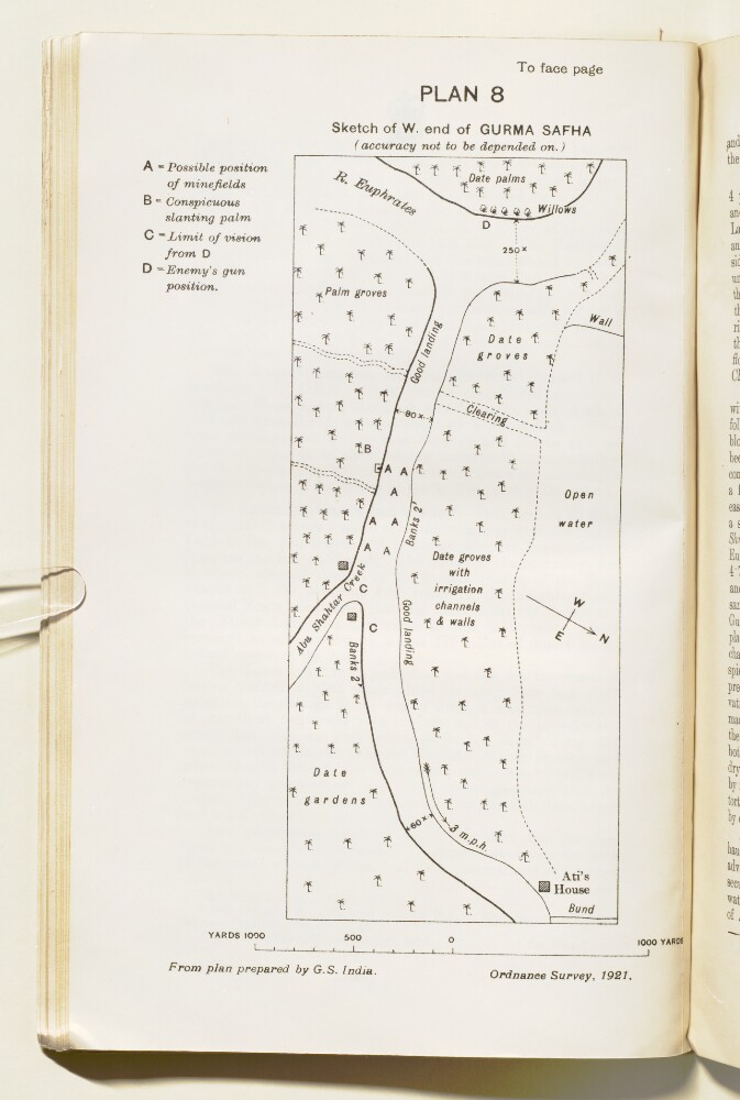
Abstract: Imprint:Ordnance Survey, 1921.Distinctive Features:Sketch map drawn from plan prepared by G.S. India showing the position of enemy’s forces along River Euphrates with landmarks lettered for reference and a key provided in the upper left-hand corner of sheet.Oriented with west to the top.Physical description: Dimensions:183 x 77 mm, on sheet 245 x 152 mm
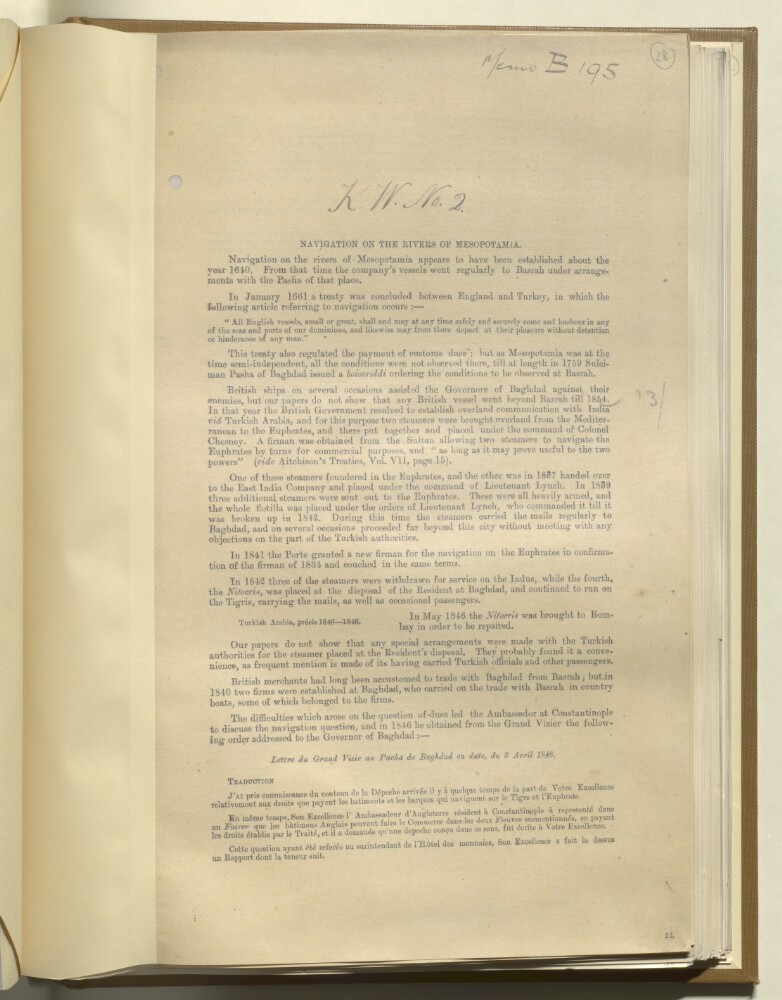
Abstract: The file provides an account of the navigation of the rivers of Mesopotamia from 1640, with a series of extracts from despatches, letters, reports, a diary, a treaty, and an order. It details agreements between England and Turkey; the movements of British steamers within the region; the question of the payment of dues and navigation rights; the maintenance costs of steamers; and highlights disturbances hindering navigation.It was written by F De Lesseps, Foreign Department, India Office.The file includes three extracts in French.Physical description: Foliation: the foliation sequence for this description commences at f 28, and terminates at f 31, as it is part of a larger physical volume; these numbers are written in pencil, are circled, and are located in the top right corner of the recto side of each folio. An additional foliation sequence is present in parallel between ff 28-31; these numbers are also written in pencil, but are not circled. Pagination: the file also contains an original printed pagination sequence.
Abstract: This item consists mostly of copies and extracts of correspondence and minutes cited in, or enclosed with, letters to and from the Government of Bombay [Mumbai]. It is the first of two items on the subject of the Euphrates expedition of 1835-37 (the other item is IOR/F/4/1701/68746).The item concerns the latter stages of the Euphrates expedition and the decision of the Government of Bombay to continue the expedition beyond its originally-assigned duration. It mostly consists of reports and letters prepared by Colonel Francis Rawdon Chesney, the leader of the expedition. The topics covered are:The ascent and descent of the Tigris river as far as Bagdad [Baghdad] by the
Euphratessteamer, from September to October 1836The ascent and descent of the Euphrates river by the
Euphratessteamer, from October to November 1836, including the damage suffered to one of the engines and the arrangements made for the mail being carried by the steamer to be conveyed onwards to BritainLocal reactions to the expeditionThe activities of the
Euphratesfollowing the departure of Colonel Francis Rawdon Chesney, the leader of the expedition, including the ascent and descent of the Karoon [Karun] river, and the return to BagdadThe assessments of Chesney and other members of the expedition of their achievements, and their recommendations for maintaining steamers on the Euphrates.Physical description: Foliation: the foliation sequence (used for referencing) commences at the first folio with f 86 and terminates at f 148, as it is part of a larger physical volume; these numbers are written in pencil, are circled, and are located in the bottom right corner of the recto side of each folio.Pagination: the volume also contains an original pagination sequence.
Abstract: This file contains despatches regarding British military
operations on the Euphrates river carried out from 26 June to 25 July 1915. The file
contains an introductory letter from General Sir John Eccles Nixon of Indian
Expeditionary Force "D" to the Chief of the General Staff, Army Head Quarters,
India (folios 4-5) that is followed by two reports written by Major-General Sir George
Frederick Gorringe, Commander of 12th Indian Division.The first report concerns operations from 26 June to 5
July (folios 6-9) and the second (folios 21-34) concerns operations from 6 July to 25
July.Both reports contain a number of appendices containing
further details of the military operations and also include several maps and
illustrations related to the operations (folios 12-13, 16, 19-20 and 36-38).Physical description: Condition: A bound, printed volume.Foliation: The file's foliation sequence commences
at the front cover and terminates at the inside back cover; these numbers are written in
pencil, are circled, and are located in the top right corner of the recto side of each
folio.Please note that folio 51 is housed within folio
52.Pagination: The volume also contains an original printed
pagination sequence.
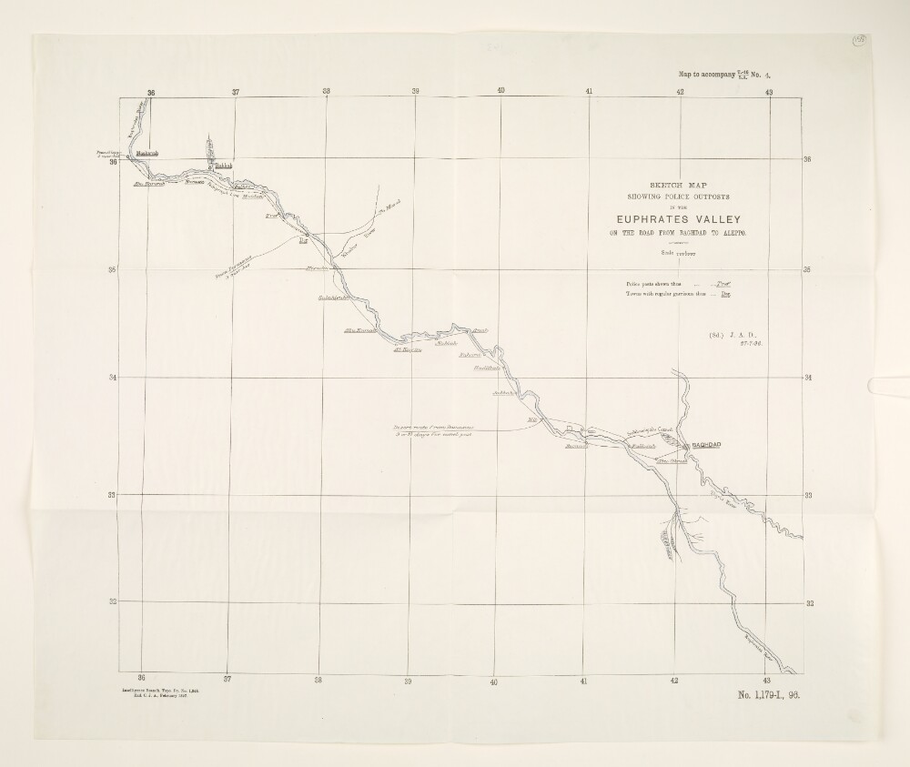
Abstract: The map shows the Euphrates river, from north of Maskanah to south of Baghdad. The names of police posts along the river valley are underlined with a single line, and the names of towns with regular garrisons are underlined with a double line. The map also shows part of the Tigris river.The map bears the printing statements ‘Intelligence Branch. Topo. Dy. No. 1,848. Exd. C. J. A., February 1897.’, ‘(Sd.) J. A. D., 27-7-96.’ and the reference number ‘No. 1,179-I., 96.’Physical description: Materials: Printed on paperDimensions: 384 x 457mm on sheet 472 x 562mm
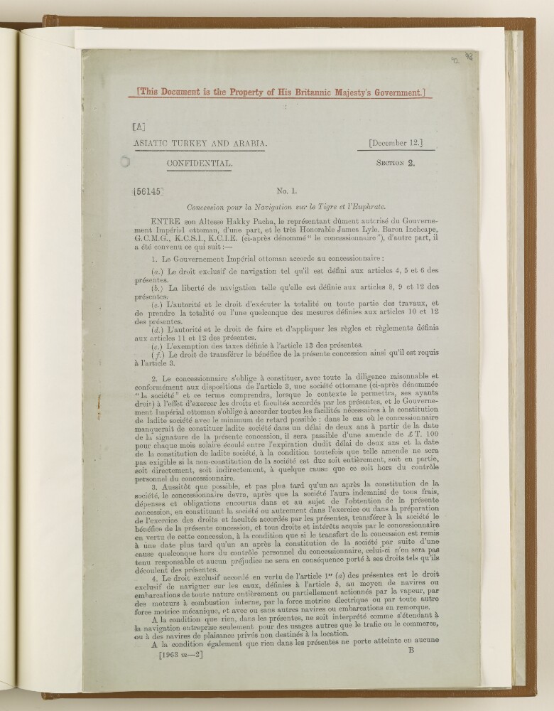
Abstract: The item consists of a concession for navigation on the Tigris and Euphrates rivers, which sets out terms and conditions.It was signed by the Grand Vizier of Ottoman Empire (Ibrahim Hakki Pasha) and Baron Inchcape (James Lyle Mackay) – on behalf of the Secretary of State for India, on 12 December 1913.The main body of the document is in French.Physical description: 1 item (7 folios)
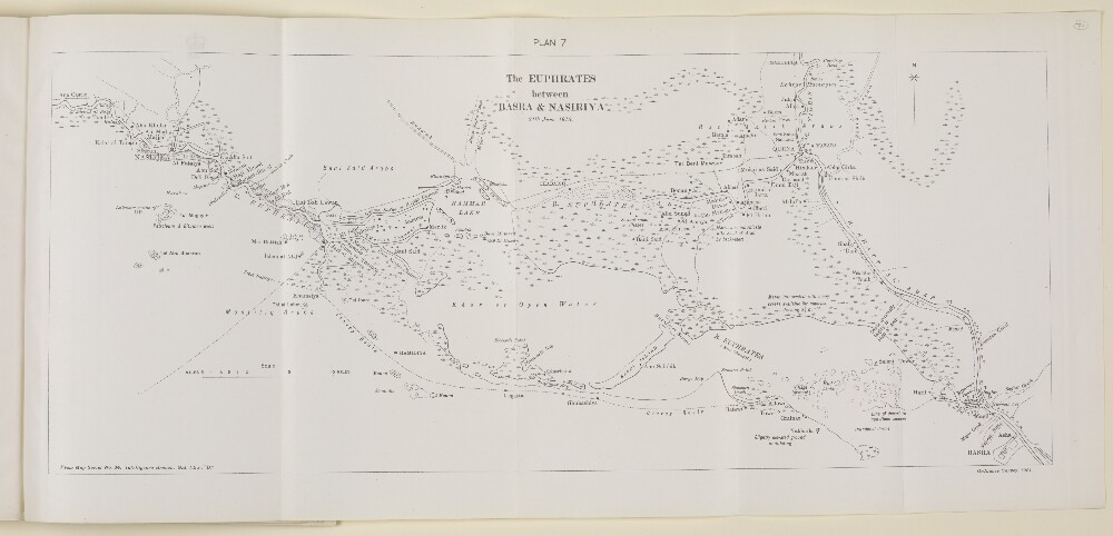
Abstract: Imprint:Ordnance Survey, 1921.Compiled from map produced by the Intelligence Branch G.S. I.E.F. “D” serial no. 34.Distinctive Features:Relief shown by contours.General map of the Euphrates River between Basra and Nasiriya [Nasiriyah] showing various channels with marshes depicted in detail.Convoy route from Nasiriya to Allowi [Alawi] indicated by pecked line.Physical description: Dimensions:201 x 488 mm, on sheet 245 x 533 mm