« Previous |
1 - 12 of 18
|
Next »
Number of results to display per page
Search Results
1. ‘Military Report on ’Arabistan (Area No. 13).’
- Description:
- Abstract: Confidential military report on Arabistan [Khūzestān] compiled by Air Headquarters, Iraq, and printed by the Government of India Press, 1924.The report contains nine chapters (numbered I-IX) and seven appendices (A-G) as follows:chapter I – history (general, ancient, modern, political attitude);II – geography (boundaries, area, general description, altitude, mountains, rivers and fords, towns and villages, tracts of land, islands, fortified places, political divisions);III – climate (general, temperature, winds, rainfall, mirages, general medical and sanitary conditions, principal diseases, conditions affecting aviation and military operations);IV – economic resources (general, labour, agriculture, livestock, manufacture, power, commerce, customs, banking, revenue, tables of imports and exports);V – ethnography (general, population, races, religions, languages);VI – tribes (general, armed forces, tribes in relation to possible centres of disturbance, political attitudes, military considerations, tribal action, punitive measures, recapitulation, lists of tribes);VII – personalities;VIII – communications (general, communications by sea, inland waterways, railways, telegraphs and telephones, post, aerodromes and possible aerodromes, wireless and visual communication, principal routes by land, sea and river);IX – administration (general, government establishments, northern province, southern province);appendix A – bibliographical notes;B – weights and measures, coinage and time;C – glossary of topographical terms;D – Karun river [Rūd-e Kārūn] regulations;E – concession granted to the “Nasiri Company”;F – customs schedule;G – Anglo-Persian Oil Company.The volume contains a single map in a pocket attached to the inside back cover (folio 180).Physical description: Foliation: the foliation sequence (used for referencing) commences at the front cover with 1, and terminates at the inside back cover with 181; these numbers are written in pencil, are circled, and are located in the top right corner of the recto side of each folio.Pagination: the file also contains an original printed pagination sequence.
2. ‘Military Report on Southern Persia’
- Description:
- Abstract: Confidential military report compiled in the Intelligence Branch, Department of the Quarter Master General of India, by Captain George Samuel Frederick Napier, 2nd Battalion, Oxfordshire Light Infantry, Staff Captain. The report was printed in Simla at the Government Central Printing Office, 1900.The volume begins with a preface, written by Lieutenant-Colonel A Barrow, Assistant Quartermaster General, Intelligence Branch, Simla, on 12 April 1900 (folio 8).Part one of the volume comprises ten chapters (I-X) covering:geography (general description, coastline, land frontiers, mountain systems, rivers and lakes)harbourscommunications (roads, maritime, inland water, and telegraphs)climate (general description, rainfall, winds in the Persian Gulf, pathology of Southern Persia)resources (agricultural, commercial, industrial, labour, production, animals, and transport)ethnography (races and religions, and languages)history (early history, Russo-Persian wars, Anglo-Persian wars up to 1856, the Anglo-Persian War of 1856-57, the subsequent history of Southern Persia, and commercial history)administration (systems, administrative divisions, financial system, money, weights and measures)naval and military (navy, army, fighting material, and arms)political (internal and external relations, British representatives in Southern Persia, and representatives of other powers in Southern Persia)Part two of the volume comprises four appendices (A-D) covering:climate (an abstract of Fahrenheit thermometer readings)resources (bazaar prices, average rates of transport, rates of freight, pack transport rates, labour, animal and crop resources in some of Southern Persia’s principal towns and villages);ethnography (list of the principal tribes of Arabistan, and lists of tribes of other regions)a ‘gazetteer of some of the more important towns and villages of Southern Persia, on or near lines of communication’Four maps are also included in the volume’s front pocket (folios 2-5).Physical description: Foliation: the foliation sequence (used for referencing) commences at the front cover with 1, and terminates at the inside back cover with 75; these numbers are written in pencil, are circled, and are located in the top right corner of the recto side of each folio.Pagination: the file also contains an original printed pagination sequence.
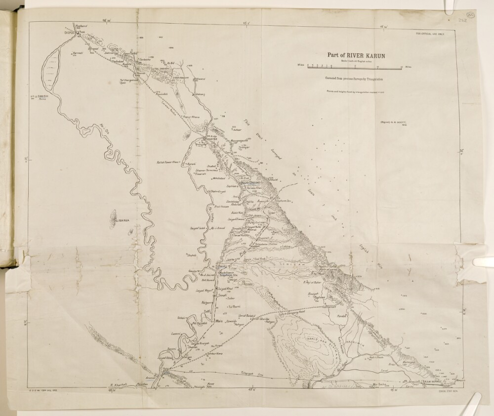
3. 'Part of River Karun'
- Description:
- Abstract: The map shows part of the Karun River, the area surrounding Shustar.The map indicates hydrology, settlements, relief (shown by hachures), pipe and telephone lines, roads and routes, telecommunications and oil infrastructures.The map was corrected from previous surveys by triangulation, and is signed by George Batley Scott and printed by General Staff India.Physical description: Materials: printed on paperDimensions: 530 x 640 mm
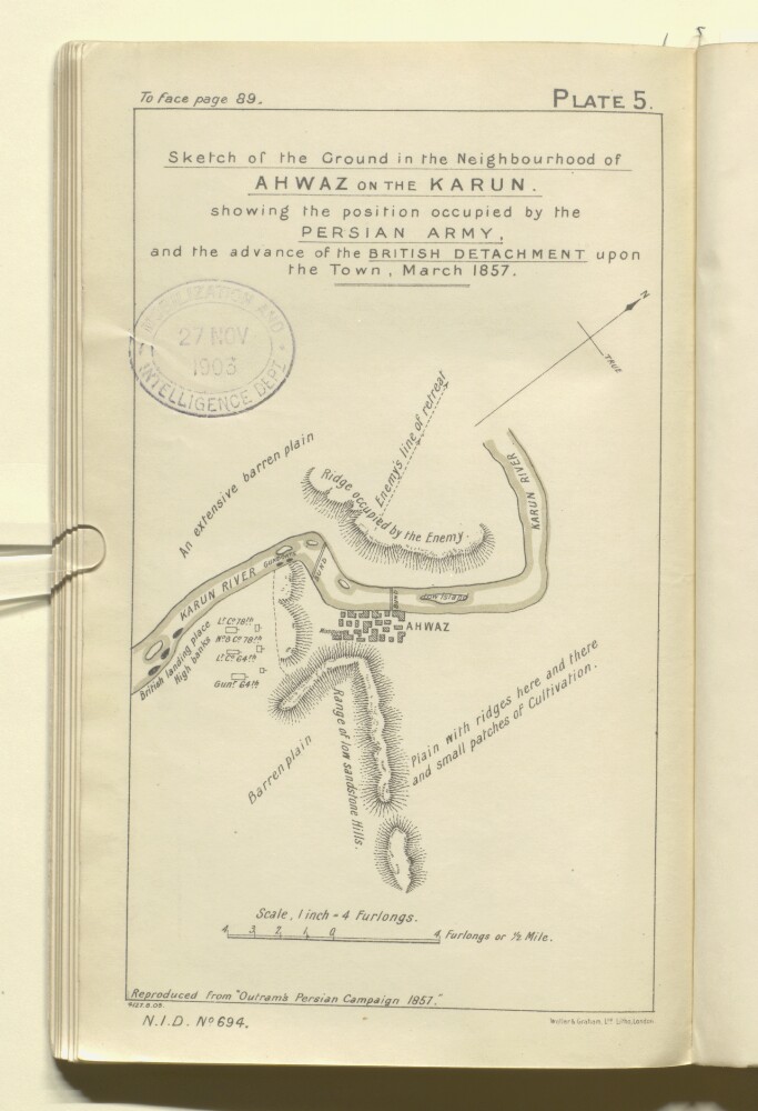
4. 'Sketch of the Ground in the Neighbourhood of AHWAZ ON THE KARUN. showing the position occupied by the PERSIAN ARMY, and the advance of the BRITISH DETACHMENT upon the Town, March 1857.'
- Description:
- Abstract: The map shows a region around Ahwaz in south-western Persia, indicating the position occupied by the Persian army, and the landing place and advance of British troops. The map also indicates hydrology and buildings, with some indication of relief, and brief descriptions of topography.The map is Plate 5 in 'Persian Gulf and Gulf of Oman' (Naval Intelligence Department No. 694), 1903, and is 'Reproduced from "Outrams Persian Campaign 1857"'.A printing statement reads, 'Weller & Graham, Ltd. Litho, London.'.Physical description: Materials: Printed on paperDimensions: 213 x 127mm, on sheet 244 x 148mm
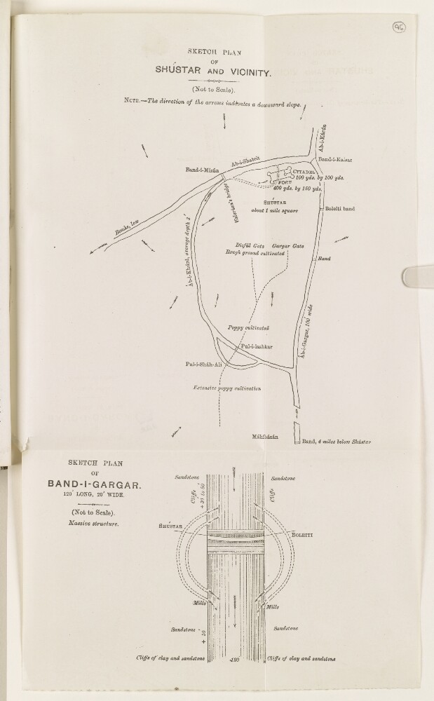
5. ‘Sketch plan of Shústar and vicinity.’
- Description:
- Abstract: Sketch of Shústar [Shūshtar] showing the Karun river, canals, fort and citadel, bridges (including the Band-i-Kaisar [Band-e Kaisar]), and areas cultivated with poppies. The arrows on the sketch indicate the direction of downward slopes.Physical description: Dimensions: 200 x 150 mm, on sheet 342 x 202 mm.Materials: Printed on paper.
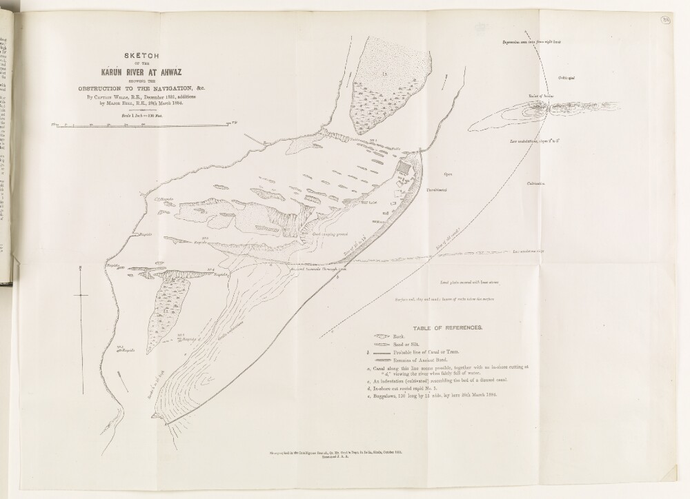
6. ‘Sketch of the Kárún River at Ahwaz showing the obstruction to the navigation, &c.’
- Description:
- Abstract: Sketch map of the Karun River at Ahwáz [Ahvāz], showing obstructions to the river’s navigation, produced by Captain Henry Lake Wells of the Royal Engineers, in December 1881, with additions made by Major Mark Sever Bell of the Royal Engineers, on 28 March 1884. The map, with accompanying key, indicates: rocks; sand and silt banks; rapids; the remains of an ancient bund, or embankment; the probable line of a canal or tram; buildings at Ahwáz, including mosque and fort; the nature of land on the right bank of the river (cultivated, uncultivated, good camping ground, level plain). Numbered annotations on the map refer to descriptions, written by Wells, in the enclosing volume (ff 87-88).A note at the bottom of the map states that the map was produced in the Intelligence Branch of the Quartermaster General’s Department in India, Simla, October 1884, and examined by ‘J.A.A.’Physical description: Dimensions: 420 x 580 mm.Materials: Printed on paper.
7. ‘Persian Gulf gazetteer. Part 1. Historical and political materials. Précis of Persian Arabistan affairs.’
- Description:
- Abstract: The volume, stamped ‘Secret’ on the front cover and frontispiece, is part 1 (historical and political materials) of a précis of Persian Arabistan affairs. It was prepared by Judge Jerome Antony Saldanha of the Bombay Provincial Civil Service, and published in 1903 by the Government of India Foreign Department, Simla, India.The contents of the volume run as follows:Chapter 1, entitled Internal affairs, 1876-1904, including: early history of the region, up until 1873; early history of the Kaab tribe; murder of Shaikh Lufti, Kaab chief; death of Haji Jabir Khan, Governor of Mohammerah [Khorramshahr], and Shaikh Mizal’s succession; local chiefs and governors between 1878 and 1883; Govenor-Generals of Arabistan; trouble in the Kaab districts, and release of Shaikh Mizal’s brother Mahomed; disturbances in Arabistan and Persian intrigues, 1888; narrative of events, 1891-97; murder of Shaikh Mizal [Maz’al bin Jabir bin Merdaw al-Ka’bi] and succession of his brother, Shaikh Khazal [Khaz’al bin Jabir bin Merdaw al-Ka’bi], 1897.2. Karun river[Rūd-e Kārūn] navigation and irrigation schemes, 1871-79, including a history of the navigation and irrigation schemes, 1871-77; proposed railways from Rehst [Rasht] to Teheran, and from Teheran to the Karan river; question of navigation of the Karun, 1878-79.3. Karun river navigation and irrigation schemes, 1881-83, including: an historical overview; navigability; trade routes; general remarks. Four appendices follow chapter 3: A) Reports by Colonel Edward Ross, Political Resident in the Persian Gulf, on the Karun river navigation; reports by Captain Henry Wells on the Ahwaz canal; memoranda on the Karun river by Sir Henry Rawlinson; a report comparing routes from Ispahan [Eşfahān] to the sea, by Captain Wells; and Felix Vauvillier’s scheme for establishing water communication between Kermanshah [Khorramshahr] and Dizful [Dezfūl] (in French).4. Opening of the Karun to navigation of all nations, 1888-89.5. Obstacles in the way of the British enterprise on the Karan river, including: the erection of warehouses and business premises on the banks of the river; misunderstanding over tonnage dues and certification; charges against Mr John Gaskin over irregular conduct and his employment of private servants; navigation of the Upper Karun; rival enterprises and intrigues of the Shaikh of Mohammerah; embargo on grain; fanatical outbreaks of local tribes and Persian soldiers against British interest.6 . Karun river subsidy, 1890-1900.7. Appointment of consular officers in Arabistan, including: the appointment of Mr William McDouall as Vice-Consul for Mohammerah, 1890; the appointment of Major Edmund Boteler Burton to act for McDouall; the appointment of Lieutenant David Lorimer as Vice-Consul for Arabistan; the appointment of a consular surgeon for Arabistan; headquarters and accommodation for the Vice-Consul and Consular Surgeon at Arabistan; attack on Lieutenant Lorimer and Colonel Douglas.8. Construction of roads in aid of the Karun river trade.9. Desire of Shaikh Khazal to place himself under British protection: interference of Belgian customs administration in Mohammerah Customs and British intervention, 1898-1904, including Shaikh Khazal seeks British protection, 1898-99; proposed establishment of Persian customs at Mohammerah and Shaikh Khazal’s appeal to the British 1900-04; presence of Belgian customs boats on the Shat el-Arab, 1904.10. Attempted change in the system of collection of customs on the Karun river, 1902-03.11. Disturbed state of Arabistan: attacks on the Shushan[ Sūsa] : measures for its protection.12. Restoration of Ancient Elam: projected irrigation works in Arabistan, 1903-04.The appendix at the end of the volume is a memorandum on the Kaab tribe and Mohammerah, dated 6 January 1844, and written by Sir Henry Rawlinson, Political Agent in Turkish Arabia.Physical description: Foliation: The foliation sequence commences at the front cover and terminates at the inside back cover; these numbers are written in pencil, are circled, and are located in the top right corner of the recto side of each folio.Pagination: The volume also contains an original printed pagination sequence, with page numbers located top and centre of each page.
8. 'A note on communications and irrigation in the Persian province of Arabistan'
- Description:
- Abstract: This note on communications and irrigation in Arabistan was written by Sir George Cunningham Buchanan and was printed in Simla at the Government Monotype Press. The information in the note is divided using sub-headings which include:general descriptioncommunicationsthe Karun Riverirrigation (in Shushter and Ahwaz)navigationproposals for improved communicationsFolios 8-9 contain photo illustrations of the Karun River and Ahwaz Rapids.Four maps are enclosed at the back of the file (folios 11-14).The file was previously marked confidential.Physical description: Foliation: the foliation sequence for this description commences at the front cover with 1, and terminates at the inside back cover with 15; these numbers are written in pencil, are circled, and are located in the top right corner of the recto side of each folio.Pagination: the volume also contains an original printed pagination sequence between ff 4-7.
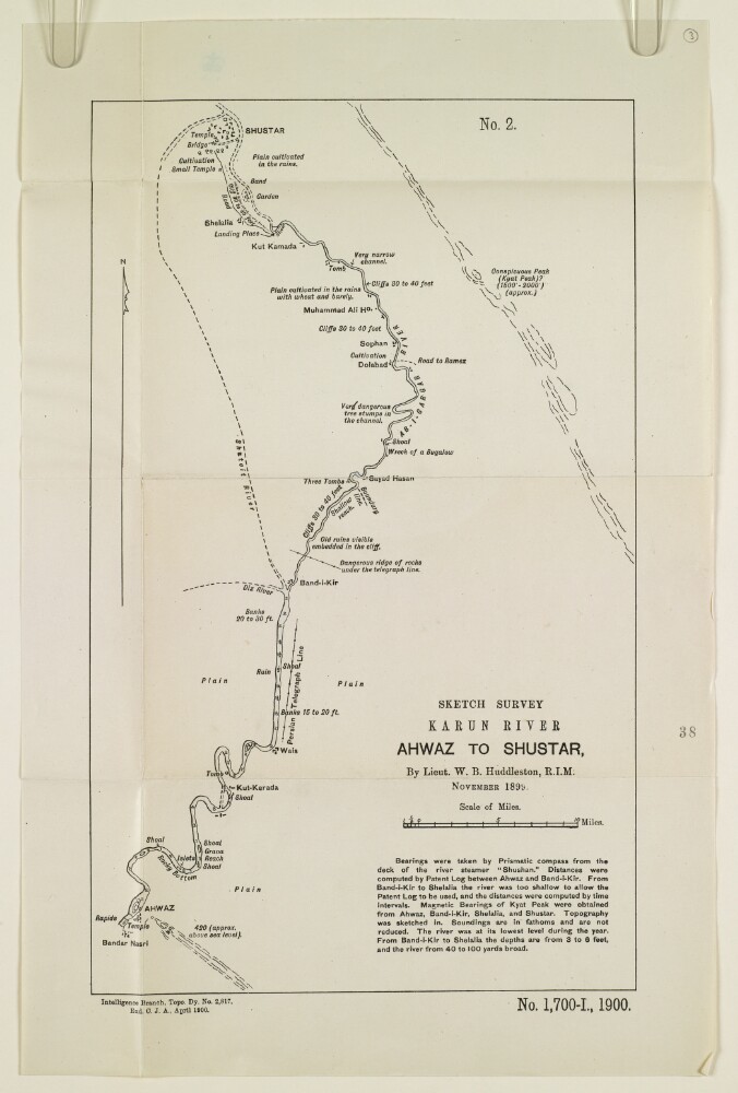
9. ‘Sketch Survey Karun River Ahwaz to Shustar, By Lieut. W. B. Huddleston, R.I.M. November 1899.’
- Description:
- Abstract: The sketch map shows the course of the river Karun from Ahwaz [Ahvāz] to Shushtar, based on a survey undertaken by Lieutenant Willoughby Baynes Huddleston of the Royal Indian Marine in November 1899. The map indicates: the course and nature of the river; soundings, measured in fathoms; the height of banks, shoals; channel hazards; plains; notable landmarks; roads; and river tributaries. A note below the map title states that the bearings were taken by prismatic compass from the deck of the river steamer Shushtan, at a time of year when the river was at its lowest annual point. The note gives further information on the methods used to record river measurements and bearings.Other labels on the map: at the top, ‘No. 2’; at the bottom: ‘Exd C.J.A.’Physical description: Dimensions: 354 x 217 mm, on sheet 419 x 275 mm.Materials: Printed on paper.
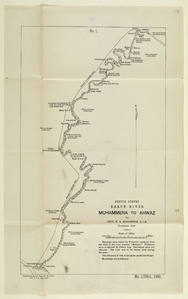
10. ‘Sketch Survey Karun River Muhammera to Ahwaz by Lieut. W. B. Huddleston, R.I.M. November 1899’
- Description:
- Abstract: Sketch map showing the course of the river Karun from Muhammera [Khorramshahr] to Ahwaz [Ahvāz], based on a survey undertaken by Lieutenant Willoughby Baynes Huddleston of the Royal Indian Marine in November 1899. The map indicates: the nature and course of the river; soundings, measured in fathoms; the height of banks, given in feet; plains; villages; and other features, such as tombs and mounds. A note below the title of the map states that bearings were taken with a prismatic compass from the deck of the river steamer Malamir, at a time of year when the river was at its lowest annual point.Other labels on the map: at the top, ‘No. 1’; at the bottom: ‘Exd C.J.A.’Physical description: Dimensions: 406 x 244 mm, on sheet 486 x 302 mm.Materials: Printed on paper.
11. 'Précis of the Affairs of the Persian Coast and Islands, 1854-1905 By J A Saldanha, BA LL B'
- Description:
- Abstract: This volume is a collection of correspondence about the Persian Coast, selected by Jerome A Saldanha and printed in Simla in 1906.The volume is divided into twelve chapters:Internal Affairs, with list of officials and events (folios 7-16);Claims of the Imam of Maskat [Muscat] to the islands of Kishm, Angaum and Ormuz and the town of Bandar Abbas and its dependencies (folios 17-30);Anglo-Persian War of 1856-57. British Expedition to the Persian Gulf and Karun River (folios 31-34);Various attempts made to establish Persian influence in the Persian Gulf, 1887-1905 (folios 35-39);Residency appointments, establishments, and guards and buildings on the Persian Coast and Islands (folios 40-49);British extra-territorial jurisdiction on the Persian Coast and Islands (folios 50-62);Questions of Status (folios 63-69);Claims of British subjects and protegés against the Persian Government and Officials and Persian subjects (folios 70-80);Certain miscellaneous affairs with regard to British relations with Persia (folios 81-87);Infringement of British Commercial Rights (folios 88-94);Introduction of Belgian Customs Administration and new Tariff, 1900-1905 (folios 95-100);Persian interference with the British Postal arrangements (folios 101-103).Physical description: Foliation: the sequence commences at the front cover, and terminates at the inside back cover; these numbers are written in pencil, are circled, and are located in the top right corner of the recto side of each folio. The volume also contains an original printed pagination sequence.
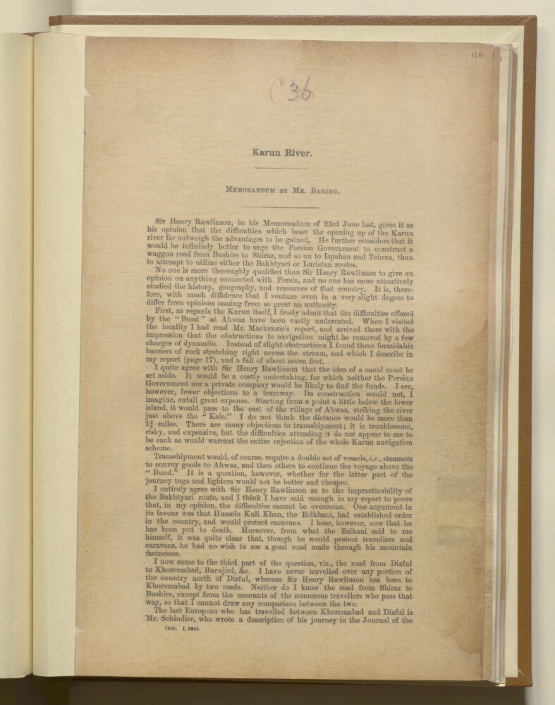
12. 'Karun River: Memorandum by Mr Baring'
- Description:
- Abstract: The memorandum is a response from Walter Baring to Sir Henry Creswicke Rawlinson's argument that the potential benefits of opening up the Karun [Kārūn] River to steam navigation are outweighed by the potential problems (see IOR/L/PS/18/C35). It argues that the Karun River scheme should not be completely abandoned, and that the transhipment of goods could bypass the natural obstruction to steam vessels at Ahwaz [Ahvāz]. It also includes some discussion of some of the overland routes into Persia.Physical description: Foliation: the foliation sequence commences at f 136 and terminates at f 137, as it is part of a larger physical volume; these numbers are written in pencil, and are located in the top right corner of the recto side of each folio. Pagination: the item also contains an original pagination sequence.
- « Previous
- Next »
- 1 Current Page, Page 1
- 2