1 - 2 of 2
Number of results to display per page
Search Results
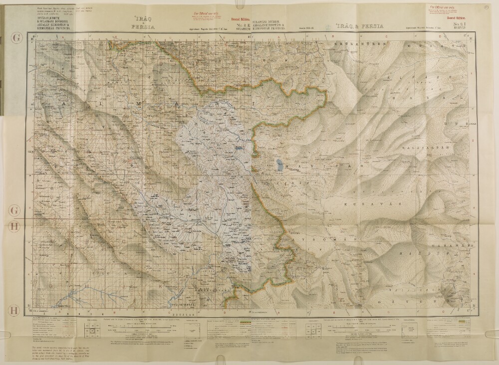
1. 'IRĀQ & PERSIA'
- Description:
- Abstract: The map is found in the Report of the Operations connected with the Occupation of Penjwin between April 18th and May 7th, 1927, promulgated by Command of the Air Council. It shows Diyālah [Ustān Diyālá], Kirkuk, and Sulaimāni [As Sulaymānīyah] divisions in Iraq; and Ardalān (Kurdistān) and Kirmānshah [Kermānshāhān] provinces in Persia. It indicates cities, towns and settlements, railways, telegraph lines, roads, tracks, paths, hydrology, relief with contours, and spot heights.Notes in the bottom margin describe the map compilation methodology, and contain an index to sheets, and two keys to symbols.The map consists of two sheets pasted together. A portion of a third sheet is pasted over the western half.Published under the direction of Colonel C H D Ryder, Surveyor General of India. Originally published in 1923, this 2nd edition with slight alterations was published in 1925. Heliozincographed at the Survey of India Offices, Calcutta.Physical description: Materials: Printed in colour on paperDimensions: 435 x 711mm, on sheet 583 x 801mm
2. ‘Persia & Kurdistan. Relative of a journey thro’ parts of – undertaken by Commander Jones of the Indian Navy, & Major Rawlinson C. B. Political Agent in Turkish Arabia – Vol: 1’
- Description:
- Abstract: This item consists of copies of correspondence, minutes, memoranda, and consultations cited in, or enclosed with, political letters from the Government of Bombay. The correspondents are: the Government of Bombay; Captain Lynch, Officiating Superintendent of the Indian Navy; and Commander Felix Jones. It is the first in a series of two items on Jones’s travels.The item concerns Jones’s account of his travels accompanying Major Henry Rawlinson, Political Agent in Turkish Arabia [Ottoman Iraq] from Baghdad to Sulemaneyeh [Sulaymaniyah] via Kirmanshah [Kermanshah] and their separate return to Baghdad, to investigate the border between the Persian [Iranian] and Ottoman Empires prior to the Second Treaty of Erzroum [Erzurum]. The account includes frequent latitude and longitude bearings, observations of the temperature, and exact timings, as well as remarks on local history, the people Jones met, and descriptions of ancient ruins and inscriptions with etymological and historical conjectures. A detailed description of the Behistan [Behistun] Inscription appears on folios 670-675, and the Tak-i-Bostan [Taq-e Bostan] sculptures are described on folios 679-681. The item does not contain a copy of the map which Jones created.The places visited include:The River Diyleh [Diyala]Village of Bakuba [Baqubah]Shehraban [Al Miqdadiyah]The Holwan River [Nahr Alwand]Kasri Shirim [Qasr-e Shirin]Sar-puli-Zohab [Sarpol-e Zahab]Sar-mil [Sarmil]Kirrind [Kerend-e Gharb]Kirmanshah [Kermanshah]Mahidasht [Mahi Dasht]Halebjah [Halabja]Sulemaneyeh [Sulaymaniyah].The item contains a contents page and the title page of the item contains the following references: ‘Draft no 586/49’, ‘Coll[ection]: 3’, and ‘Collection No 1 of No 139’.Physical description: Foliation: the foliation sequence (used for referencing) commences at the first folio with f 630, and terminates at f 706 as it is part of a larger physical volume; these numbers are written in pencil, are circled, and are located in the bottom right corner of the recto side of each folio.Pagination: the item also contains an original pagination sequence.