Abstract: The item consists of:Extract from Lord Chelmsford (Frederick John Napier Thesiger)'s private letter of 18 October 1916: regarding the Government of India's existing responsibilities in relation to Mesopotamia; the likelihood of those responsibilities increasing; whether it might be possible to dissociate India from the administration of Mesopotamia; India's involvement in the Persian Gulf; India's likely future involvement with Basrah [Basra]; and Lord Chelmsford's vision for a largely independent administration in Mesopotamia, with India controlling external relations and military operations.Memoranda on the future administration of Mesopotamia, prepared at Mr Chamberlain's request, by Sir Thomas William Holderness, 9 January 1917: Regarding the potential need for a new agency, instead of the Government of India, to be responsible for territory in Southern Mesopotamia and agreements with Arab States that might be acquired at the outcome of the war (World War One); and the possible requirements and implications of administering such an area.Notes by Sir (Frederic) Arthur Hirtzel, 30 December 1916: regarding the need for a new dependency to be created, to include Arabia, Egypt, and the Soudan [Sudan]; the expected future role of the British Government in the Persian Gulf; and the likely need for the Government of India to take on responsibilities in Southern Persia.Physical description: Foliation: The foliation for this description commences at folio 102 and terminates at folio 103, as it is part of a larger physical volume; these numbers are written in pencil, are circled, and are located in the top right corner of the recto side of each folio. An additional foliation sequence is also present in parallel between folios 6-153; these numbers are also written in pencil, but are not circled, and can be found in the same position as the main sequence.
Abstract: The file consists primarily of correspondence and telegrams between the War Office and the General Officer Commanding Mesopotamia regarding the conflict and attacks taking place in Kurdistan. The file includes the following related subjects: the creation of the Kurdish National committee and the Kurdish movement; the massacre of Christians in Kurdistan; the reactions of anti-British, anti-foreign and anti-Christian subjects; the various disturbances in Zakho, Amadia [Al ‘Amādīyah], Sulaimaniyeh [Sulaymaniyah], and Kerkouk [Kirkuk]; the British response to the Kurdish movement, with discussion of punitive action and strategic operations; British prisoners, and casualties and deaths among British soldiers; the repatriation of Christians; the armistice frontier in the southern boundaries of the British forces' area in Persia.Principal correspondents are the War Office; General Officer Commanding, Mesopotamia; GHQ Egypt [General Headquarters Egypt]; GHQ Constantinople [General Headquarters Constantinople]; C in C India [Commander in Chief India]; Political Agent Baghdad; Civil Commissioner, Baghdad.Physical description: Foliation: the foliation sequence (used for referencing) commences at the front cover with 1, and terminates at the inside back cover with 103; these numbers are written in pencil, are circled, and are located in the top right corner of the recto side of each folio. An additional foliation sequence is also present between ff 3-102.
Abstract: This printed memorandum, dated 25 October 1918, is a note by the India Office concerning a War Office memorandum of 21 October 1918 (E.C. 2042). It concerns political service in the Middle East in the context of the First World War and defines responsibility for the administration of Mesopotamia [Iraq] between the Foreign Office and the Government of India and India Office.Physical description: Foliation: The foliation for this description commences at folio 97, and terminates at folio 101, as it is part of a larger physical volume; these numbers are written in pencil, are circled, and are located in the top right corner of the recto side of each folio. An additional foliation sequence is also present in parallel between folios 11-158; these numbers are also written in pencil, but are not circled, and can be found in the same position as the main sequence.
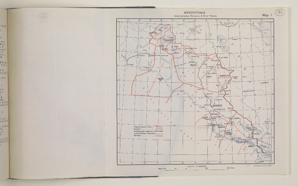
Abstract: Imprint:Ordnance Survey, 1916.Distinctive Features:General map of Mesopotamia [Iraq] showing administrative division with headquarter stations underlined and provinces outlined in red. Shows rivers, railway lines with Turco-Persian boundary indicated by dash-dot line.Includes table of reference at lower left of the sheet.Physical description: Dimensions: 159 x 172 mm
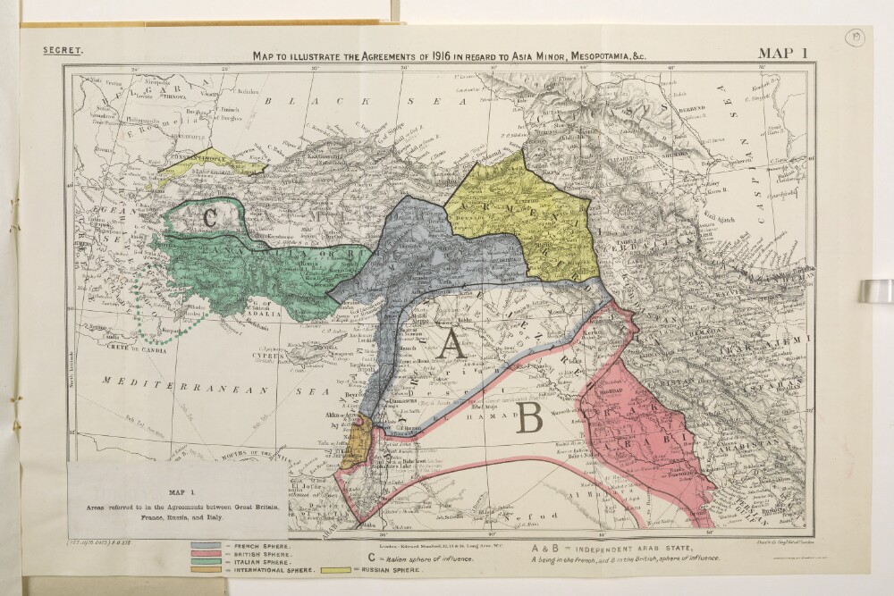
Abstract: Classified 'Secret'.Map forms a part of Mss Eur F112/570, ff 17-23.The original map bears the secondary title 'A Map of Turkey in Asia'. A small paper sheet has been pasted over this and bears a later secondary title 'Map 1. Areas referred to in the Agreements between Great Britain, France, Russia, and Italy.'Map bears the printed designation 'Map 1'. Depicts a proposed division of the Ottoman Empire into spheres of influence and protection by the Allied powers. The division is based on agreements reached between 1916 and 1918. Portrays hydrology, relief by spot heights and hachures, roads and tracks, railways, submarine telegraph lines, settlements, place names and international boundaries. Various blocks of overprinted colour shading correspond to French, British, Italian, Russian and International spheres of influence, including provision for an independent Arab state within the French and British spheres.The base map bears the imprint 'London: Edward Stanford, 12, 13 & 14, Long Acre, W.C.' The printer's imprint 'Harrison & Sons, Lith. St. Martins Lane, W.C.' and print code '(155.11/18.6423) F[oreign].O[ffice].238.' have been added later.Another copy of this map is at Mss Eur F112/570, f 26.Physical description: Materials: Printed in colourDimensions: 243 x 388mm, on sheet 287 x 449mm
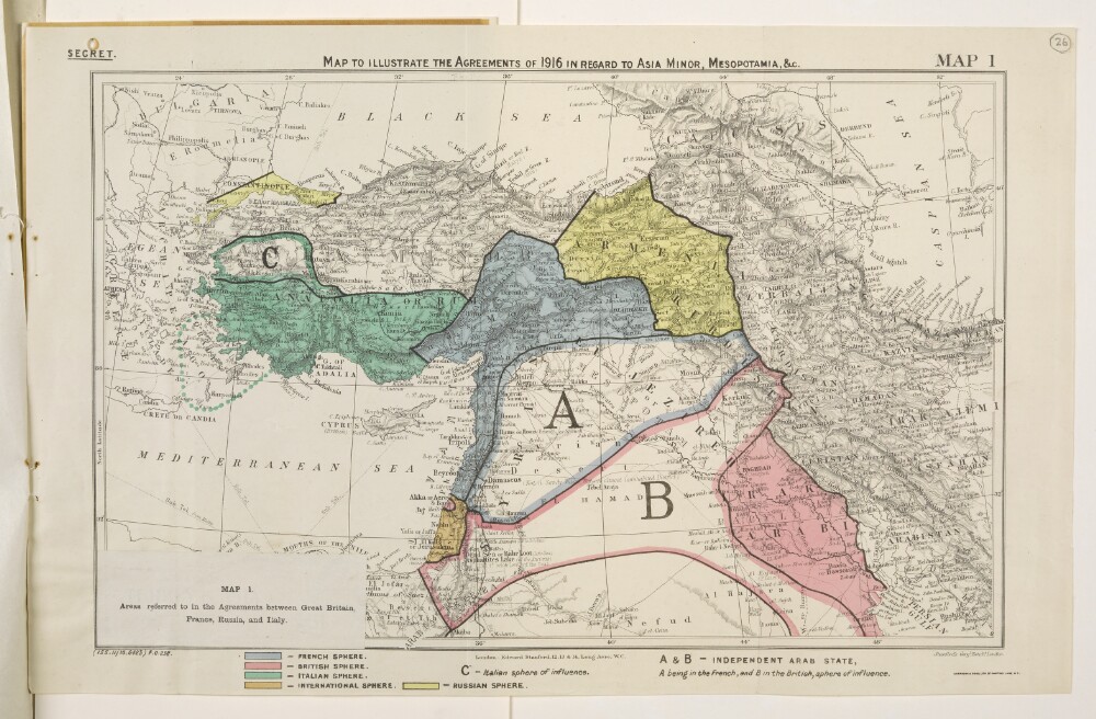
Abstract: Classified 'Secret'.Map forms a part of Mss Eur F112/570, ff 24-30.The original map bears the secondary title 'A Map of Turkey in Asia'. A small paper sheet has been pasted over this and bears a later secondary title 'Map 1. Areas referred to in the Agreements between Great Britain, France, Russia, and Italy.'Map bears the printed designation 'Map 1'. Depicts a proposed division of the Ottoman Empire into spheres of influence and protection by the Allied powers. The division is based on agreements reached between 1916 and 1918. Portrays hydrology, relief by spot heights and hachures, roads and tracks, railways, submarine telegraph lines, settlements, place names and international boundaries. Various blocks of overprinted colour shading correspond to French, British, Italian, Russian and International spheres of influence, including provision for an independent Arab state within the French and British spheres.The base map bears the imprint 'London: Edward Stanford, 12, 13 & 14, Long Acre, W.C.' The printer's imprint 'Harrison & Sons, Lith. St. Martins Lane, W.C.' and print code '(155.11/18.6423) F[oreign].O[ffice].238.' have been added later.Another copy of this map is at Mss Eur F112/570, f 19.Physical description: Materials: Printed in colour on paperDimensions: 243 x 388mm, on sheet 287 x 449mm
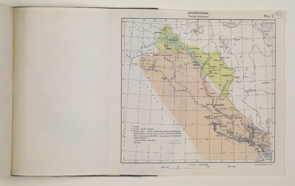
Abstract: Imprint:Ordnance Survey, 1916.Distinctive Features:General map of Mesopotamia [Iraq] showing ethnic division with the approximate location of the various ethnic groups (Arabs, Kurds and mixed races) across the region marked in colour and explained in a table of reference at the lower left of the sheet. Shows rivers, railway lines with Turco-Persian boundary indicated by dash-dot line.Same base map as IOR/L/MIL/17/15/41/1, p 360A.Physical description: Dimensions: 159 x 172 mm
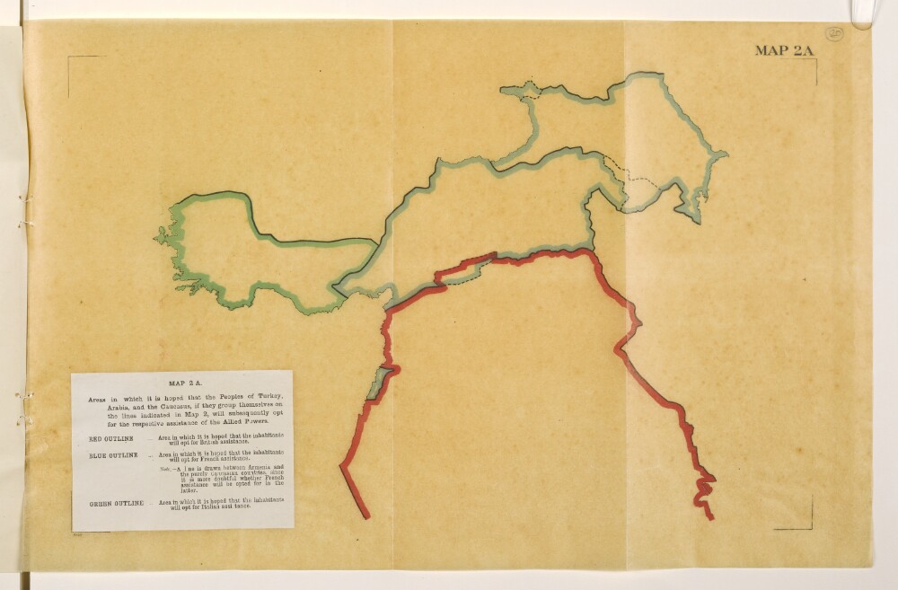
Abstract: Map is an overlay to Mss Eur F112/570, f 21 and forms a part of Mss Eur F112/570, ff 17-23.The title and legend are printed on a small paper sheet that has been pasted over the south-west corner of the map. Map portrays, by variously coloured boundaries, areas in which it is 'hoped that the inhabitants will opt for [British, French or Italian] assistance'. Bears the imprint '8146.' [Published by the Political Intelligence Department, Foreign Office, 21 November 1918.]Another copy of this map is at Mss Eur F112/570, f 27.Physical description: Materials: Printed in colour on tracing paperDimensions: 243 x 393mm, on sheet 290 x 450mm
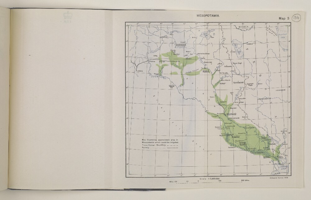
Abstract: Imprint:Ordnance Survey, 1916.Distinctive Features:General map of Mesopotamia [Iraq] showing in green the approximate areas for proposed irrigation scheme. Shows rivers, railway lines with Turco-Persian boundary indicated by dash-dot line. Includes table of reference at lower left of the sheet.Same base map as IOR/L/MIL/17/15/41/1, p 360A.Physical description: Dimensions: 159 x 172 mm
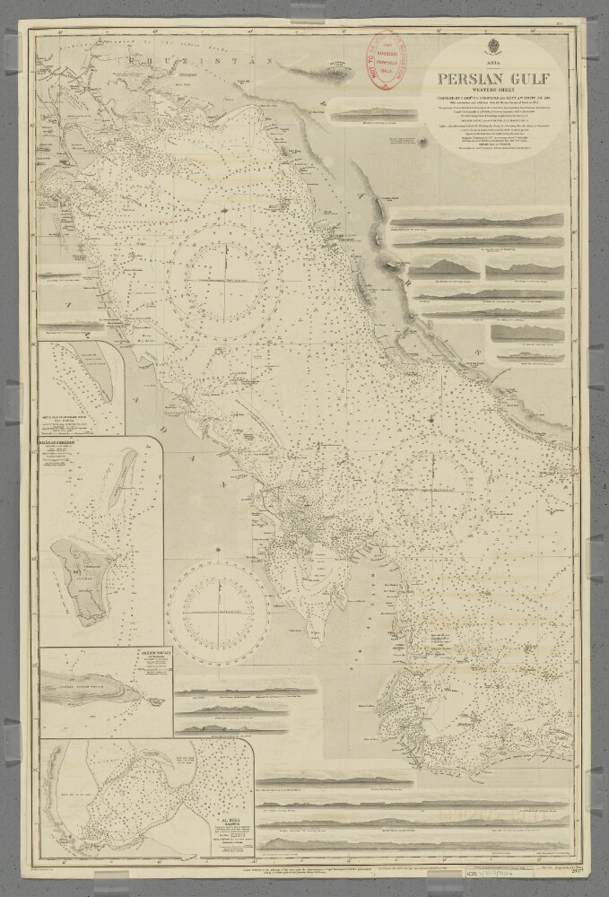
Abstract: Chart 2837b.Hydrographic chart covering the Persian Gulf from Al Basra, Mesopotamia [Al Basrah, Iraq] westwards to approximately longitude 53° 20’E. Also includes the adjacent coastal areas of Persia [Iran], Mesopotamia and the eastern Arabian Peninsula. Portrays hydrology, including depths by soundings and contours, anchorages, sands and rocks, relief by spot heights, hachures and rock drawings, vegetation, settlements, forts and place names, and includes topographical notes and navigational aids, including lights and prominent landmarks.Includes insets of Ras Tanura, Arabia [Ras Tannurah, Saudi Arabia] at scale 1:18,360; Kharag [Kharg] & Khargu, Persia [Iran] at scale 1:72,913; Henjam Sheikh Shu'aib, Persia [Lavan Island] at scale 1:121,520; and Al Bida, Al Katr [Al Bid', Qatar] at scale 1:60,760.Eighteen annotated sketches of significant navigational views at unspecified scales on both the north and south coasts are also included.Chart surveyed and compiled by Commander Charles Golding Constable and Lieutenant Arthur William Stiffe, Indian Navy (1860); also incorporates surveys by Captain John Michael Guy and Captain George Barnes Brucks, East India Marine (1821-29); with corrections and additions from the Marine Survey of India to 1911. Engraved by J & C Walker. Published at the Admiralty 1862, with new editions 1876, 1890, 1900, 1903 and 1912, and small corrections.The sheet bears the stamps:'Not to be used for navigation. For reference purposes only' in red on the map face.The number '30.2' in black in the upper right margin.Physical description: Materials: Printed on paperDimensions: 964 x 622mm, on sheet 1020 x 666mm
Abstract: This printed memorandum is a report on the future constitution of Mesopotamia [Iraq] split into two parts: the first (folios 83-84), dated 1 November 1919, and is written by Colin Campbell Garbett (initialled C C G); and the second (folios 84 to 86), dated 3 November 1919, is written by Sir Frederic Arthur Hirtzel (initialled A H). The report is divided into three sections: the first section gives an outline of the administrative status of Mesopotamia; the second section gives administrative details concerning the 'Tribal Areas', 'Rural Communities', 'Towns and Cities' and 'Central Government' with a tree illustrating administrative responsibilities of the Minister of Finance, Minister of Revenue and Agriculture, Minister of Commerce and Industry, Minister of Interior, and Minister of Justice; and the third section concerns suggestions for the administrative structure. The second part of the memorandum consists of a note by Hirtzel commenting on Garbett's report.Physical description: Foliation: The foliation for this report commences at folio 83, and terminates at folio 86, as it is part of a larger physical volume; these numbers are written in pencil, are circled, and are located in the top right corner of the recto side of each folio. An additional foliation sequence is also present in parallel between folios 7-153; these numbers are also written in pencil, but are not circled, and can be found in the same position as the main sequence.
Abstract: This printed memorandum is a note, dated 20 November 1918, by Sir Frederic Arthur Hirtzel of the India Office concerning British policy in Arabia. The note discusses 'The Status of the King of the Hejaz [Ḥusayn bin ‘Alī al-Hāshimī]' and 'The Status of Iraq', and largely focuses on British interests in Mesopotamia [Iraq]. The policy note makes it clear that Britain’s main objective was to gain control of the whole of Mesopotamia.Physical description: Foliation: The foliation for this description commences at folio 133 and terminates at folio 134, as it is part of a larger physical volume; these numbers are written in pencil, are circled, and are located in the top right corner of the recto side of each folio. An additional foliation sequence is also present in parallel between folios 11-158; these numbers are also written in pencil, but are not circled, and can be found in the same position as the main sequence.