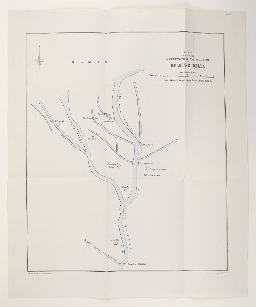
Abstract: A printed plan showing the waterways of the Helmund [Helmand] River Delta. The plan also shows settlements, buildings of note, and military camps. The plan was printed at the Survey of India Office, Calcutta [Kolkata] and is based on a sketch by Surgeon Major Brazir-Creagh [George Washington Brazier-Creagh]. It includes the printing statement ‘Reg. No. 162. Print., I. - July 98 - 123.’.Physical description: Material: Printed in colour on paperDimensions: 431 x 362mm, on sheet 552 x 437mm
Abstract: The first volume of reports produced by the Irrigation Officer of the Perso-Afghan Boundary Commission, Seistan [Sīstān], and submitted to the Government of India, Foreign Department.Contents:'Chapter I. The catchment area of the Seistan Lake. The trough of the Helmand River below Kala-i-Bist.''Chapter II. The delta of the Helmand River.''Chapter III. The inundated area.''Chapter IV. Canals, ancient and modern.''Chapter V. Rainfall in the Helmand basin.''Chapter VI. Note on the evaporation from the surface of water in Seistan.''Chapter VII. Lines of levels, maps, surveys, etc.''Chapter VIII. Discharge observations.''Chapter IX. The silt carried in the water of the Helmand River.''Chapter X. The volume available for the irrigation of the delta: the duty: the culturable area that could be brought under command.''Chapter XI. Probable rates of work if canals are made.''Chapter XII. Irrigation works suitable to the circumstances of the people.''Chapter XIII. Works required to gain complete control of the river for the irrigation of the delta.''Chapter XIV. Probable cost of, and income, and percentage of profit from the irrigation works.''Chapter XV. Drainage scheme for the inundated area.''Chapter XVI. Schemes for utilising some large depressions either as escape, or impounding reservoirs.''Chapter XVII. Impounding reservoirs in the trough of the Helmand: control of the floods by works in the catchment area.'Appendices:'Appendix 1. The Hazarajat and the country drained by the Farah Rud and Harud Rud.''Appendix 2. The trough of the Helmand River below Kala-i-Bist.''Appendix 3. Detailed measurements of depths of water evaporated in Seistan.''Appendix 4. Extracts from "The Irrigation of Mesopotamia" by Sir William Willcocks, KCMG.''Appendix 5. Comparison of rates at Quetta with these on the Chenab and Jhelum Canals.''Appendix 6. Rates of cost and of income on the Punjab Perennial Canals.''Appendix 7. The manufacture of lime at the Consulate, Seistan.''Appendix 8. Details of the cost of the work on the buildings erected by the Imperial Bank.''Appendix 9. Note on lime, bricks and stone for large works in Seistan.''Appendix 10. Comparison of rates likely to obtain in Mesopotamia with those in Egypt by Sir William Willcocks, KCMG.''Appendix 11. Note by W A Johns, Esq., Railway Reconnaissance Officer, on the cost of excavating in the hard Seistan clay, and driving tunnels or
kariztherein.''Appendix 12. On the cost of excavation in the culturable soil of the delta and in the hard tough alluvial of the high plateaux or
dasht.''Appendix 13. The meaning of the words
clayand
silt.''Appendix 14. Dates on which the Sar-i-Shela flowed in 1903.''Appendix 15. Expenditure incurred on the Irrigation Party.''Appendix 16. List of maps and sections packed in a tin lined case and filed in the Foreign Office, Simla.'Physical description: Foliation: the foliation sequence for this description commences at the front cover with 1, and terminates at the inside back cover with 248; these numbers are written in pencil, are circled, and are located in the top right corner of the recto side of each folio. Pagination: the file also contains an original printed pagination sequence.The volume contains a higher than usual number of blank pages, which may have been the result of a printing error.
Abstract: The second volume of reports produced by the Irrigation Officer of the Perso-Afghan Boundary Commission, Seistan [Sīstān], and submitted to the Government of India, Foreign Department. Publication statement: Simla: Government of India Foreign Department, 1906.The commission, under the direction of Colonel Arthur Henry McMahon, was to redefine the frontier between Persia and Afghanistan in the south, and develop a formula for the division of the Helmand waters. This volume contains tabulated data collected by the Commission, and accompanies the irrigation report.Physical description: Foliation: the main foliation sequence (used for referencing) commences at the front cover with 1, and terminates at the inside back cover with 70; these numbers are written in pencil, are circled, and are located in the top right corner of the recto side of each folio. Pagination: the file also contains an original printed pagination sequence (i, 127pp).
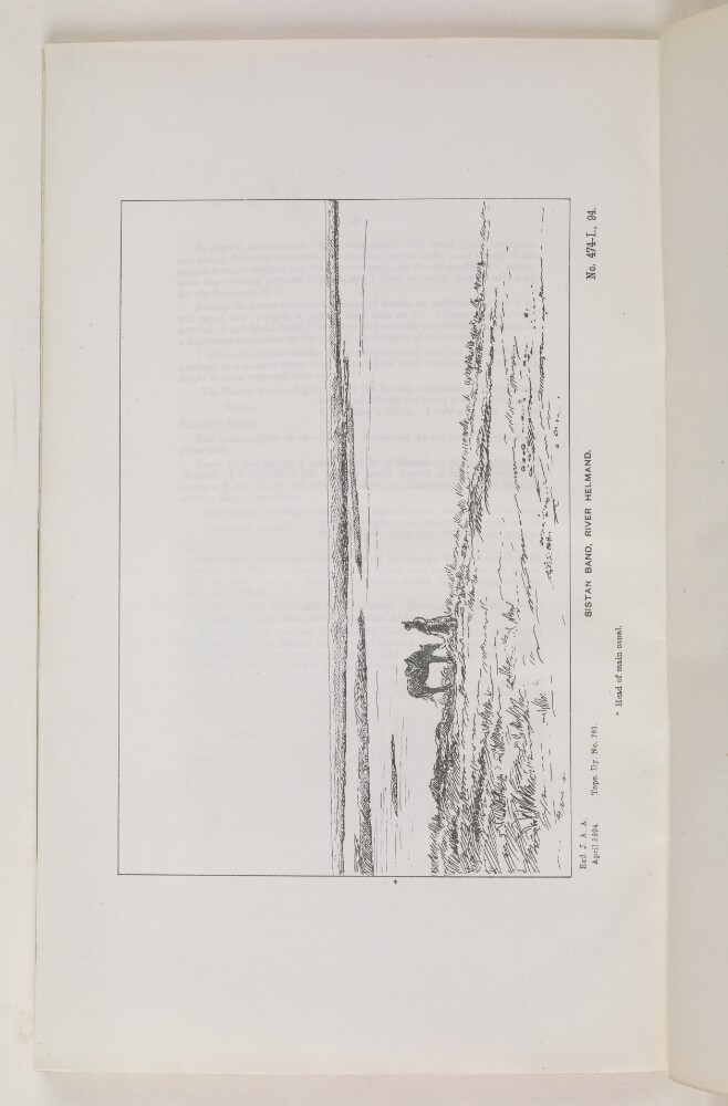
Abstract: A line drawing of a flat, grassy landscape. Depicted is a wide waterway, the Helmand River. By the river is a figure standing with a horse. Beneath the sketch is the following information: 'Exd. J. A. A. April 1894; Topo. Dy. No. 781.; No. 474-I., 94.' The artist is unknown.Physical description: Dimensions: 146 x 220mm
Abstract: The memorandum concerns the Seistan Water Award [Sīstān] arbitrated by Britain between Persia and Afghanistan; the award outlines the proportion of water from the River Helmond [Helmand] to be allotted to irrigation on both sides of the river. It is authored by Arthur Henry McMahon — the British commissioner appointed to draft the award — and includes his opinion on the legitimacy of these complaints.Physical description: Foliation: the foliation sequence commences at f 13, and terminates at f 20, as it is part of a larger physical volume; these numbers are written in pencil, and are located in the top right corner of the recto side of each folio. Pagination: the item also contains an original pagination sequence.