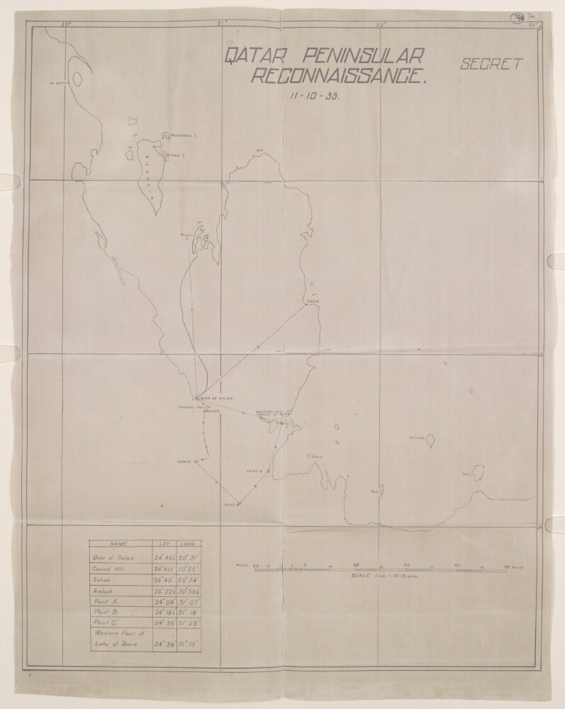
Abstract: Distinctive Features:Outline map of the Qatar Peninsula copied from the British Admiralty Chart No. 2837b and enclosed with a copy of Report on the Air Reconnaissance carried out over Qatar on 11 October 1935 (folios 72-73). Classified ‘Secret’.Shows the reconnaissance route with direction indicated. Contains a table with place names and coordinates listed.Physical description: Materials:Photographic printDimensions:452 x 361 mm, on sheet 490 x 384 mm
Abstract: The volume contains letters, telegrams, and memorandums pertaining to Anglo-Turkish negotiations brought on by the Baghdad Railway and particularly the extension to Basra. Correspondents include: Percy Cox, Political Resident at Bushire, William Shakespear, Political Agent at Kuwait, Edward Grey, Secretary of State for Foreign Affairs, Louis Mallet, Assistant Under-secretary of State for Near and Middle Eastern Affairs, Charles Marling, British Ambassador to Persia, Gerard Lowther, British Ambassador to Constantinople, George Buchanan, British Ambassador to Russia, Admiral Edmond Slade, the Board of Trade, the Government of India, the India Office, and several private companies, including Trans-Atlantic Trust Company, Anglo-Persian Oil Company, Imperial Ottoman Bank, and Imperial Persian Bank.The form of the negotiations was a series of memorandums containing proposals and counter-proposals. The issues and subjects discussed are:ownership and control of the line;custom duty increases in the region;navigation of the Shatt al-Arab, including the establishment of a commission to oversee this;transport of railway materials by the Tigris and Euphrates rivers;delimitation of the Turkish-Persian border;status and territorial limit of Kuwait;other Gulf matters, including the statuses of Bahrain and Qatar, the suppression of arms traffic, piracy, and slavery, and the protection of pearl fisheries.Folios 261-262 are a map showing the proposed territorial limits of Kuwait.Physical description: Foliation: The volume is foliated from the front cover to the inside back cover, using circled pencil numbers positioned in the top-right corner of each recto. There are two earlier foliation systems running through parts of the volume. The first uses uncircled pencil numbers in the top-right corner of recto pages, and the top-left corner of verso pages. This foliation system numbers pages if they have content on them, which is the case for all rectos and some versos. This foliation system appears intermittently through most of the volume. The other foliation system uses circled blue pencil numbers in the top-right corner of recto pages, and appears from folios 5 to 42. Numerous printed materials contained in the volume have their own internal pagination systems. The following foliation irregularities occur: 1a, 34a, 51B, 219B, 250B.
Abstract: The volume contains correspondence, memorandums, maps and newspaper cuttings relating to a proposed Baghdad to Basra railway, an extension of the German Berlin to Baghdad Railway. Correspondents include: Percy Cox, Political Resident at Bushire, William Shakespear, Political Agent at Kuwait, Edward Grey, Secretary of State for Foreign Affairs, Francis Bertie, British Ambassador to France, Louis Mallet, Assistant Under-secretary of State for Near and Middle Eastern Affairs, Arthur Nicolson, Permanent Under-secretary for Foreign Affairs, Gerard Lowther, British Ambassador to Constantinople, George Buchanan, British Ambassador to Russia, Edward Goschen, British Ambassador to Berlin, the Board of Trade, William Graham Greene, Permanent Secretary to the Board of Admiralty, the Government of India, the India Office, and Sheikh Mubarak of Kuwait.The volume covers the discussion over various matters, with numerous draft conventions and agreements sent back and forth between the various governmental offices and departments. Documents relating to Cox's successful attempts to obtain the acceptance of the agreement from Sheikh Khazal of Mohammerah and Sheikh Mubarak of Kuwait are also included. The issues discussed as matters for agreement with Turkey include:the status of Kuwait, including territorial limits and relations with Britain and Ottoman Turkey;the conservancy of the Shatt al-Arab, including the establishment of a Navigation Commission;the ownership and control of the Baghdad Railway and the question of its extension beyond Basra;the boundary between Turkish Arabia and Persia;other Persian Gulf matters such as Turkish power and influence in Katr [Qatar] and Bahrain.Other subjects that feature are Sheikh Mubarak's temporary illness, and reports of the dispatch of Turkish troops to Qatar, contrary to agreements.Physical description: Foliation: The volume is foliated from the front cover to the inside back cover, using circled pencil numbers in the top-right corner of recto pages. There is an earlier foliation system that runs through the volume, using pencil numbers in the top-right corner of recto pages, as well as the top-left corner of any verso pages bearing written or printed matter.The following anomalies occur: 1a, 1b, 1c, 1d, 104b, 278a.The following folios are foldouts: 1 (attached to inside front cover), 14, 15, 25, 46, 66, 82, 83, 89, 92, 125, 126, 208, 218-22, 231, 294, 338, 340.
Abstract: The volume contains correspondence and telegrams between the Political Department, the Colonial Office and the Secretary of State at the India Office in London, the Political Resident at Bushire, the Political Agent at Kuwait, the British Legation at Tehran and Anglo Persian Oil Company (APOC) representatives regarding the port of Basra and the disputes for the Shatt al-`Arab water-way between Kuwait and Iraq.Physical description: The foliation is written in pencil, not circled, and can be found in the top right corner of the recto side of each folio.The numbering commences at the title page with 1, 1A, 1B; and terminates with 102, which is the last number given to the fourth folio from the back of the volume.
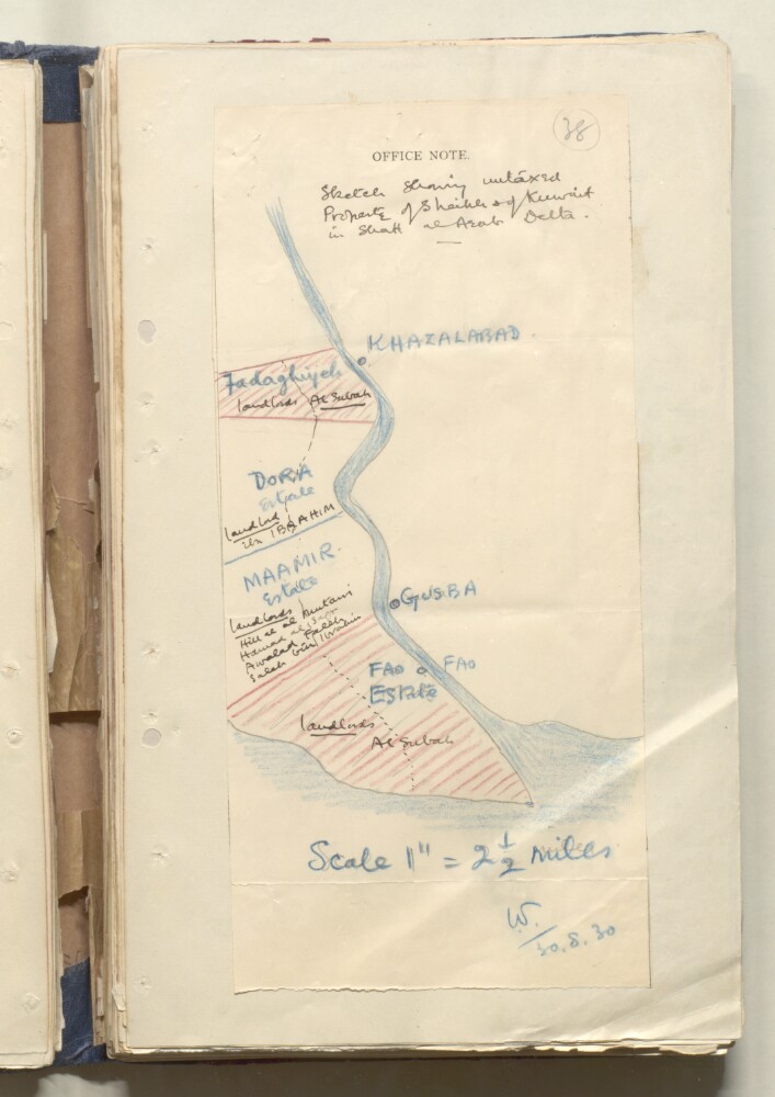
Abstract: Distinctive Features:Hand drawn rough sketch map dated 30 August 1930 enclosed with a letter from Harold Dickson to Colonel Biscoe (folios 35-37).Shows the estates along Shatt al Arab bought by Mubarak: Fadaghiyeh, Dora Maamir and Fao Estate with landlords names reported.Physical description: Materials:Pen and ink with crayon on paper
Dimensions:303 x 141 mm
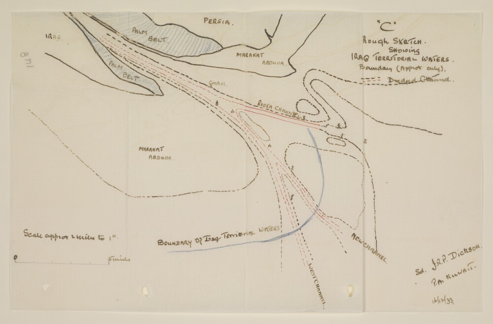
Abstract: Distinctive Features:Copy of a sketch map of the mouth and bar of the Shatt al Arab, attached to a letter no. 298.Map based on material submitted by Lieutenant Thomas, R.N, Navigation Officer of H.M.S. Shoreham, showing the approximate boundary of Iraq territorial waters towards to open sea (blue line), with channels and buoys indicated. Signed in the bottom right-hand corner ‘J.R.P. Dickson, P.A. Kuwait’ and dated ‘16/12/33’.Another copy of the map can be found at folio 149.Physical description: Materials:Pen and ink with crayon on tracing paperDimensions:205 x 324 mm
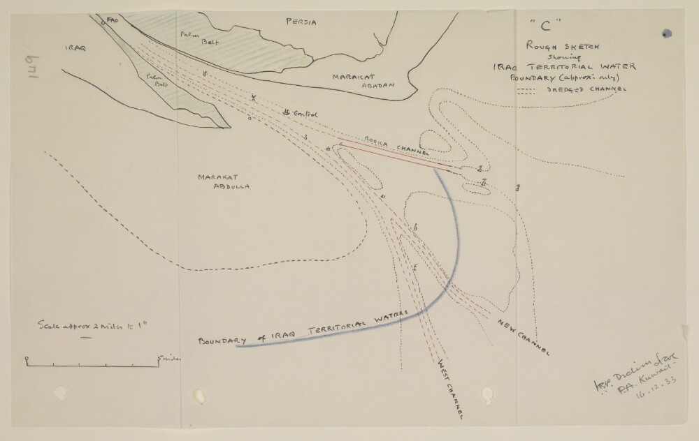
Abstract: Distinctive Features:Copy a sketch map of the mouth and bar of the Shatt al Arab, attached to a letter no. 298.Map based on material submitted by Lieutenant Thomas, R.N, Navigation Officer of H.M.S. Shoreham, showing the approximate boundary of Iraq territorial waters towards to open sea (blue line), with channels and buoys indicated. Signed in the bottom right-hand corner ‘J.R.P. Dickson, P.A. Kuwait’ and dated ’16.12.33’.Another copy of the map can be found at folio 148.Physical description: Materials:Pen and ink with crayon on tracing paperDimensions:202 x 329 mm
Abstract: Distinctive Features:Copy based on a map of Asia drawn to scale 1:1,000,000 issued by the War Office with adjustments controlled by traverses made during a survey carried out in February 1933 for the Iraq Petroleum Co. Ltd.Shows roads and wells with boundary indicated by dash-dot line.Inscriptions:On verso, in the lower right in pencil: ‘See 82/27 – V paper 51’.Physical description: Dimensions:389 x 235 mm, on sheet 417 x 329 mm
Abstract: The file is a report, compiled by the Army Headquarters and printed in 1914 at the Government Monotype Press (Simla), regarding planning for operations in Turkish Mesopotamia (Iraq). The report has been compiled on the basis of the latest information available and with approval of His Excellency the Commander-in-Chief.The report is divided into two sections. The first section, entitled 'Information' (folios 2-3), gives topographical and geographical information concerning Iraq, as well as details concerning supplies, telegraphic communications, naval and military strength, the local Arabs of Mesopotamia, and important local chiefs. A further paragraph (number 11 on folio 3v) has been pasted into the report after printing. The second section, entitled 'Plan' (folio 4), sets out a plan of operations for the occupation of Basrah [Basra] and the Shatt-al-Arab [Shaṭṭ al-‘Arab], as part of Britain's general scheme of military action against Turkey. Details are given regarding the strength of Turkish forces, landing at Umm Qasr, local chiefs, clothing and tentage, special equipment, transport, and supplies.The file also includes a map, 'Lower Mesopotamia', on folio 5, which is referenced in the text of the report.Physical description: Foliation: The foliation sequence commences at the front cover, and terminates at the inside back cover; these numbers are written in pencil, are circled, and are located in the top right corner of the recto side of each folio. The volume also contains an original printed pagination sequence.
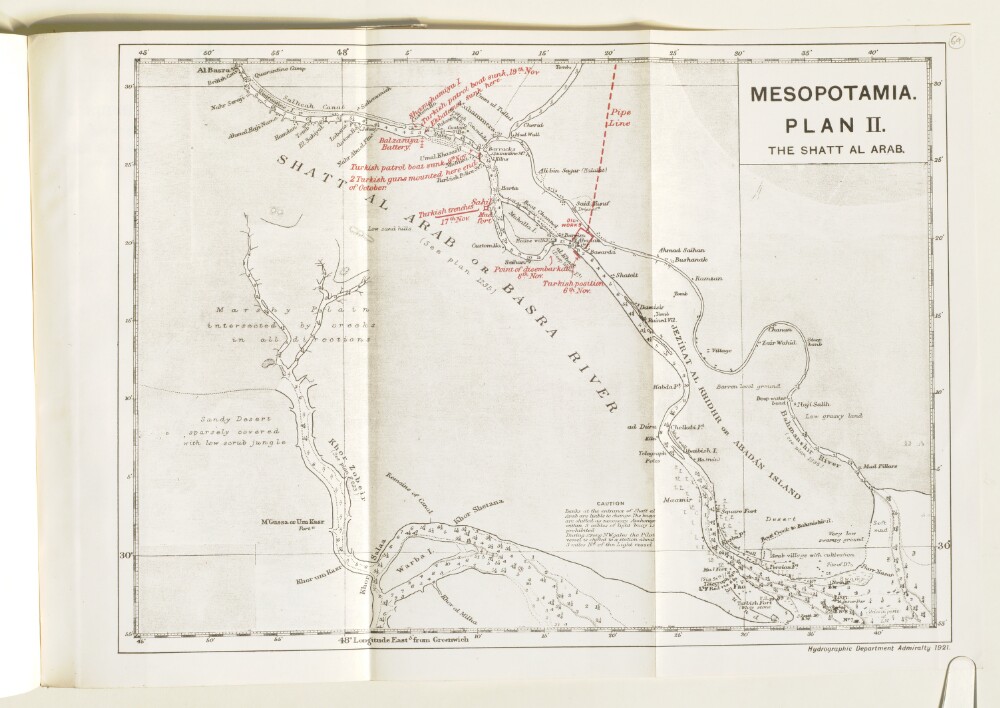
Abstract: Imprint:Hydrographic Department Admiralty, 1921.Distinctive Features:Relief shown by shading. Depths shown by soundings.Map of Shatt Al Arab with additions in red showing the movements of Turkish military forces and oil works and pipe line in Abadan area.Contains notations concerning navigation and terrain features.Physical description: Dimensions:212 x 245 mm, on sheet 298 x 355 mm
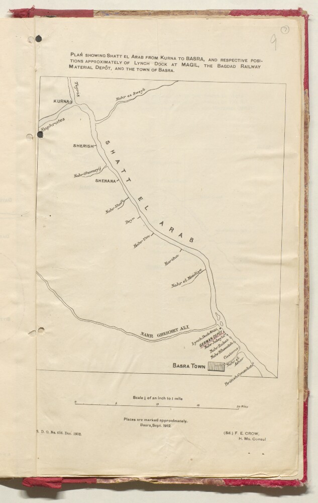
Abstract: Distinctive Features:Produced in Basra, Sept. 1912 and signed ‘Sd. F.E. Crow H. Ms. Consul’. Rough plan of area north of Basra with location of German Depot and British Consulate shown.In the bottom left-hand corner printed: ‘S.D.O. No. 606. Dec. 1912’.Physical description: Dimensions:345 x 210 mm
Abstract: Distinctive Features:Tracing of a map of the Qatar Peninsula dated 8th September 1937, sent in reference to the Residency Express letter No. 839-S.Shows the proposed Saudi-Qatar border with motor routes indicated by red pecked lines and location of wells marked. Contains a key to symbols in the lower left-hand corner.Physical description: Materials:Pen and ink on tracing clothDimensions:838 x 519 mm, on sheet 1027 x 763 mm