Abstract: The note was written by Sir Frederic Arthur Hirtzel for the India Office, 30 Nov 1918, and consists of remarks on three points drawn out from the Foreign Office memorandum:The Trucial System - disputing the assumptions made in the original memo that Great Britain effectively kept the peace over a large part of the Arabian Peninsula; and that no treaties had been made with Chief's of inland tribes, that all had been coastal tribes. Stating that the object of the treaties was maritime peace; that His Majesty's Government had always been firmly against interference in the interior of Arabia; the terms of the existing treaty with Bin Saud [‘Abd al-‘Azīz bin ‘Abd al-Raḥmān bin Fayṣal Āl Sa‘ūd, Ibn Saud]; and the India Office's opinion that there would be no benefit to extending the trucial system to the interior of Arabia.The Hejaz - detailing the India Office's thoughts on what a treaty with the King of Hejaz should consist of and how diplomatic relations should be handled.Syria - regarding what the alternative approach to Syria should be if the French refuse to give it up, and citing the opinions of Captain Wilson and Gertrude Bell that the French should be persuaded to give up some areas of Syria within their control for Armenia.Mention is also given to the Baghdad Railway and the importance of ensuring that it is British controlled.The appendix to the note contains further details on the British Government's agreement with Bin Saud, setting out the full history of events leading up to the signing of the agreement; later modifications to it; and the definition of the term 'foreign power' within the treaty.Physical description: Foliation: The sequence commences at the first folio and concludes on the last folio. It consists of pencil numbers, enclosed in a circle, located in the top right hand corner of the recto of each folio.Pagination: The booklet also has an original typed pagination sequence, with numbers printed at the centre of the top of each page, excepting page 1.
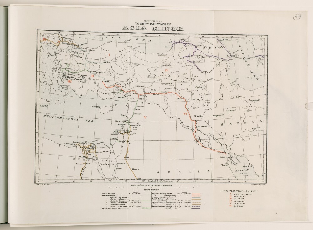
Abstract: A War Office map, dated January 1907. The map shows the following railway lines: British; French; Anglo-Franco-German; the Baghdad Railway System; the Anatolian Railway; Turkish Railways; Egyptian 'State' Railways; and Russian Railways.The map also marks out the Ordu Territorial Districts [corresponding to the seven Army Corps of the Ottoman Empire]: Constantinople [Istanbul]; Adrianople [Edirne]; Salonica [Thessaloniki]; Erzingan [Erzincan]; Damascus; and Baghdad [Baghdād].Physical description: Materials: printed on paper.Dimensions: 225 x 335mm on a sheet 325 x 440mm.
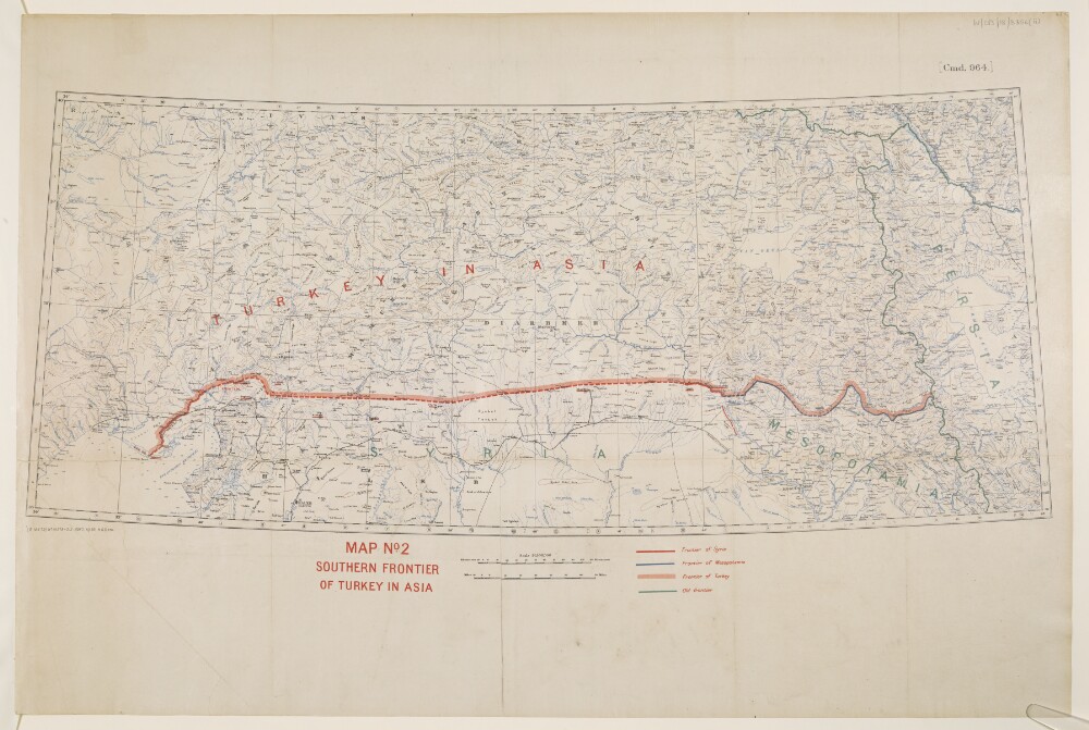
Abstract: This map shows Turkey where it is included in Asia and indicates the boundaries between Turkey, Syria, Mesopotamia and the Old Frontier. The map also indicates relief with contours.The map includes a printing statement which reads '(B 16479) WT 18378-212.5050.10/20.H&S,LTD.'Physical description: Materials: Printed in colour on paper with manuscript additions in coloured inkDimensions: 310x 733mm, on sheet 505 x 759mm
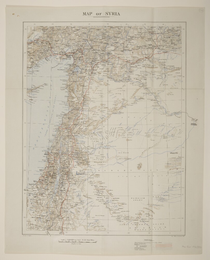
Abstract: Created by the War Office. Bears the imprint 'G[eographical].S[ection].G[eneral].S[taff]. No. 2904'. Covers Syria together with the geographical region of Palestine, present-day Jordan and Lebanon, and parts of Saudi Arabia, Turkey, Egypt and Iraq. Portrays hydrology, relief by spot heights and hachures, roads, railways, telegraphs, ancient canals (dry), settlements, place names and international boundaries (as at July 1914). Manuscript additions show supplementary map detail.Map produced from GSGS 2901 Eastern Turkey in Asia, Syria and Western Persia [Iran] [see, for example, Mss Eur F112/570, f 32], from where projection information has been obtained.The verso bears the annotation 'Syria'.Physical description: Materials: Printed in colour, with manuscript additions in pencil and crayonDimensions: 494 x 365mm, on sheet 582 x 468mm
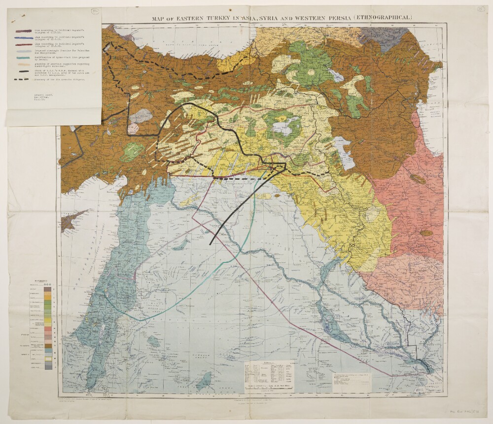
Abstract: Folio 35 is a map bearing the imprint 'Published by the Royal Geographical Society, 1910. Railways inserted to November, 1917' and the series designation 'G[eographical].S[ection].,G[eneral].S[taff]., No. 2901.' Portrays hydrology, roads, telegraphs, settlements, place names and international boundaries. The sheet bears the printed note 'International Boundaries as in July, 1914'. A 1921 full edition of this base map, including also relief, railways and ancient canals, is at Maps 46970.(44.) although lacks a GSGS designation, yet includes a set of accompanying notes published by the Royal Geographical Society in 1910, including details of compilation material.A thematic overprint in several colours portrays the geographical distribution of twenty different ethnographical groups. Eight proposed boundaries have been added in manuscript. Copies of this map, without the manuscript additions, are also filed at Maps 46990.(1.) and Maps MOD GSGS 2901.Folio 35a is an attached folio (227 x 181mm) in typescript and coloured ink that provides a key to the manuscript boundary additions on folio 35. It bears the signature block 'General Staff. War Office. 20.8.19.'Physical description: Materials: Printed in colour, with manuscript additions in coloured inkDimensions: 710 x 743mm, on sheet 785 x 912mm
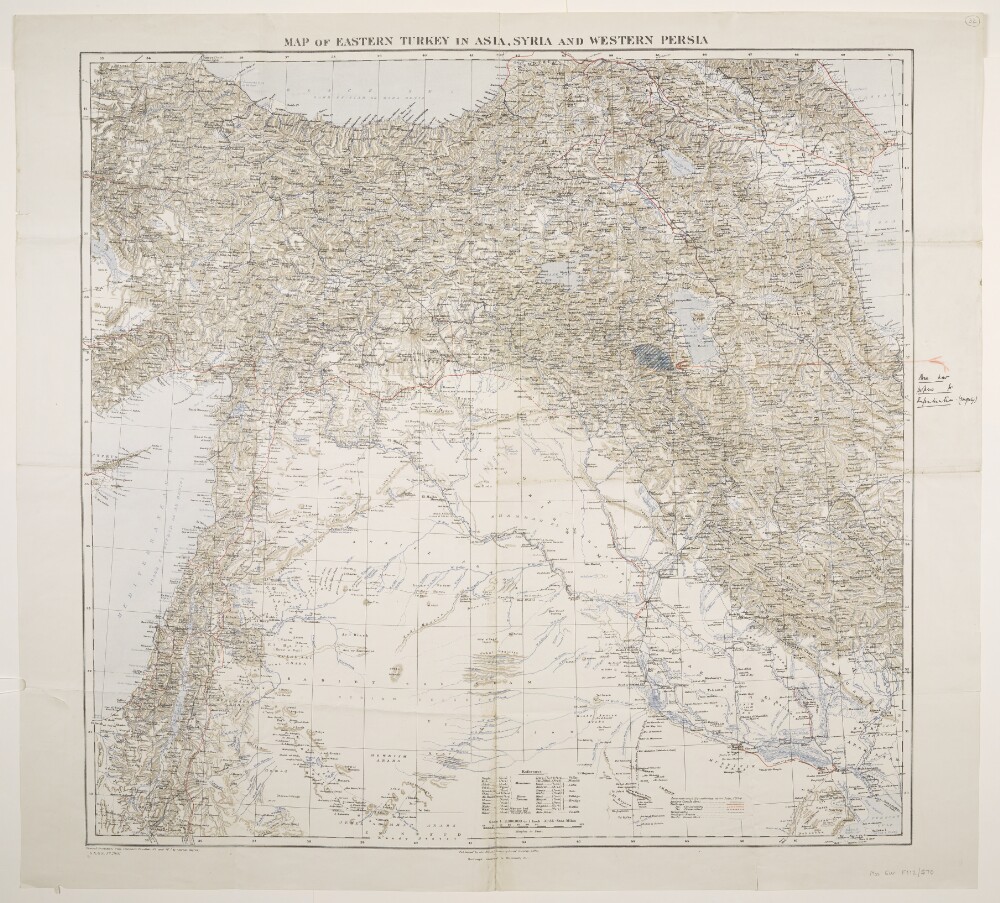
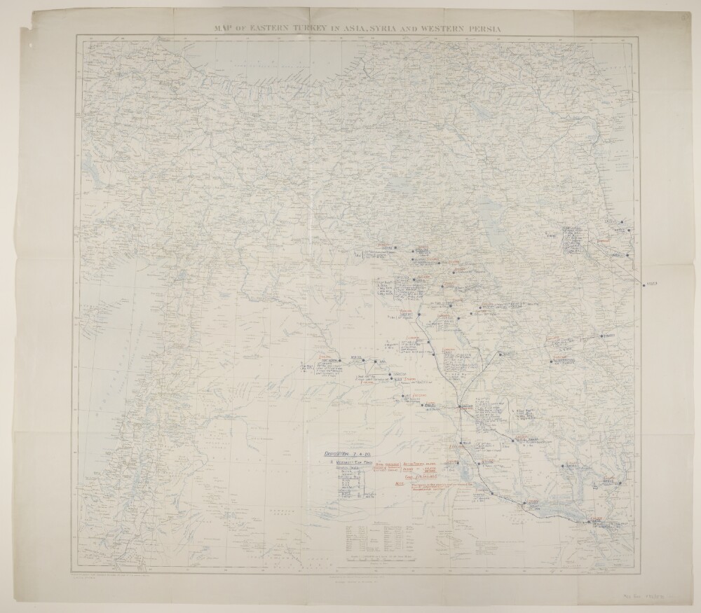
Abstract: Bears the imprint 'Published by the Royal Geographical Society, 1910. Railways inserted to November, 1917' and the series designation 'G[eographical].S[ection].,G[eneral].S[taff]., No. 2901.' Portrays hydrology, relief by spot heights and hachures, roads, railways, telegraphs, settlements, ancient canals, place names and international boundaries. The sheet bears the printed note 'International Boundaries as in July, 1914'. A 1921 edition of this base map is at Maps 46970.(44.) although lacks a GSGS designation, yet includes a set of accompanying notes published by the Royal Geographical Society in 1910, including details of compilation material.A manuscript annotation depicts an 'Area now proposed for Repatriation. (?From July)'.Verso bears the manuscript annotation 'Map of Eastern Turkey in Asia, Syria & W. Persia [Iran]'.Physical description: Materials: Printed in colour, with manuscript additions in ink and crayonDimensions: 710 x 745mm, on sheet 789 x 860mm
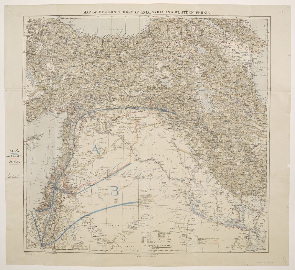
Abstract: Bears the imprint 'Published by the Royal Geographical Society, 1910. Railways inserted to November, 1917' and the series designation 'G[eographical].S[ection].,G[eneral].S[taff]., No. 2901.' Portrays hydrology, relief by spot heights and hachures, roads, railways, telegraphs, settlements, ancient canals, place names and international boundaries. The sheet bears the printed note 'International Boundaries as in July, 1914'. A 1921 edition of this base map is at Maps 46970.(44.) although lacks a GSGS designation, yet includes a set of accompanying notes published by the Royal Geographical Society in 1910, including details of compilation material.Manuscript annotations depict proposed boundaries by Sykes-Picot, the War Cabinet Committee and 'O[ttoman?].E[mpire?].[F?].A's.', and highlight two villages.Verso bears the manuscript annotation 'Asia Minor'.Physical description: Materials: Printed in colour, with manuscript additions in ink, pencil and crayonDimensions: 710 x 745mm, on sheet 789 x 860mm
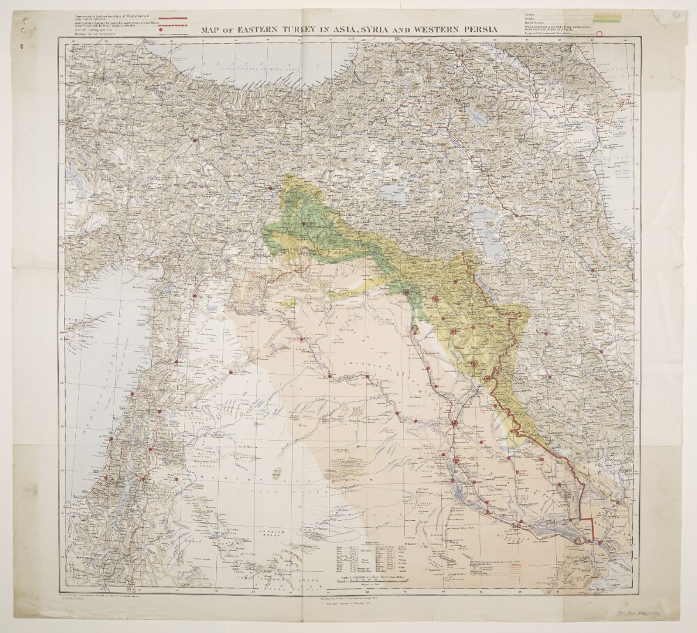
Abstract: Folios 33 and 34 are copies of the same map.Bears the imprint 'Published by the Royal Geographical Society, 1910. Railways inserted to November, 1917' and the series designation 'G[eographical].S[ection].,G[eneral].S[taff]., No. 2901.' Portrays hydrology, relief by spot heights and hachures, roads, railways, telegraphs, settlements, ancient canals, place names and international boundaries. The sheet bears the printed note 'International Boundaries as in July, 1914'. A 1921 edition of this base map is at Maps 46970.(44.) although lacks a GSGS designation, yet includes a set of accompanying notes published by the Royal Geographical Society in 1910, including details of compilation material.Coloured overprints depict areas of 'Kurds', 'Arabs', 'Mixed Races' and 'debateable lands between Arabs and Kurds'; possible boundaries for Mesopotamia; aircraft landing-grounds and railways; and proposed permanent garrisons.Physical description: Materials: Printed in colourDimensions: 612 x 745mm, on sheet 780 x 860mm
Abstract: Three copies of map sheet Geographical Section, General Staff No. 2901, comprising a base map with overprints.The base map bears the imprint 'Published by the Royal Geographical Society, 1910. Railways inserted to November, 1917' and portrays hydrology, relief by spot heights, roads, telegraphs, settlements, place names and international boundaries. The sheets bear the printed note 'International Boundaries as in July, 1914'. A 1921 edition of this base map is at Maps 46970.(44.) and includes accompanying notes (including compilation details) published by the Royal Geographical Society in 1910, although lacks a GSGS designation yet contains an additional red plate (railways) and grey plate (hachures and ancient canals) that are both lacking from this version.Overprints in red and blue depict the disposition of British and Indian troops as at 7 April 1920 and the cost per annum of maintaining them, and railway routes radiating from Bagdad.Folio 4 also contains line features [routes or boundaries?] added as pencil annotations.Physical description: Materials: Printed in colour, with manuscript additions in pencilDimensions: 693 x 728mm, on sheet 789 x 887mm
Abstract: This printed report contains a despatch (No 344436/75/19) from Lieutenant-Colonel Arnold Talbot Wilson, Acting Civil Commissioner in Mesopotamia at Baghdad, to Edwin Samuel Montagu, Secretary of State for India, dated 15 November 1919, enclosing a note by Miss Gertrude Lowthian Bell, Oriental Secretary to the Civil Commissioner, entitled 'Syria in October 1919' (folios 90-98), dated 15 November 1919.Physical description: Foliation: The foliation for this report commences at folio 89, and terminates at folio 97, as it is part of a larger physical volume; these numbers are written in pencil, are circled, and are located in the top right corner of the recto side of each folio. An additional foliation sequence is also present in parallel between folios 7-153; these numbers are also written in pencil, but are not circled, and can be found in the same position as the main sequence.
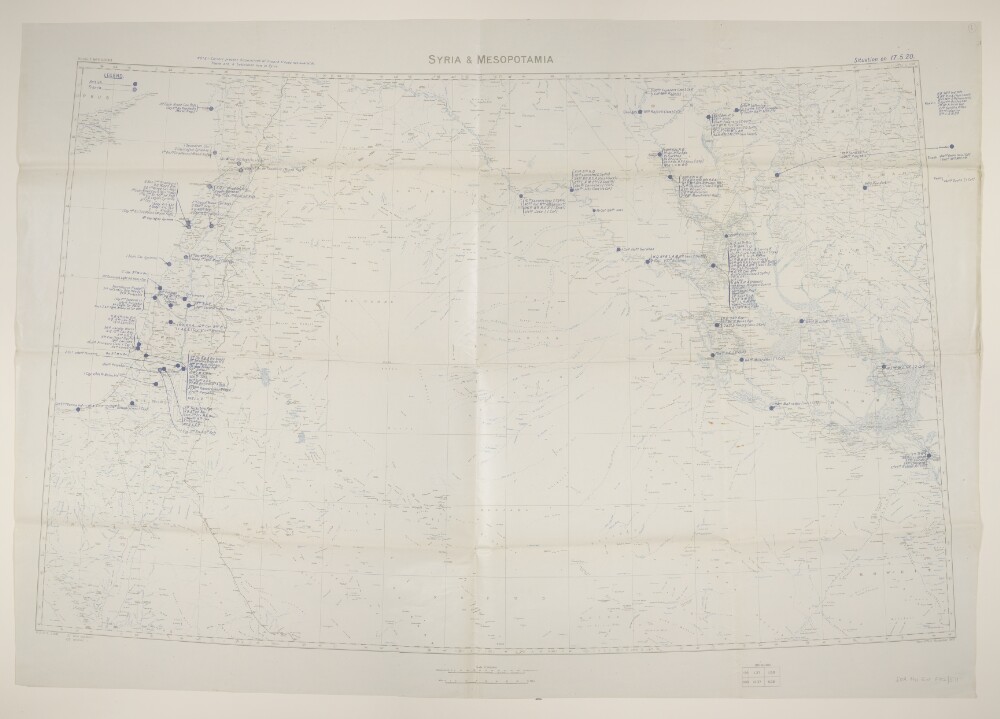
Abstract: Geographical Section, General Staff No. 2931, sheet 'Syria & Mesopotamia', comprising a base map with overprint.The base map bears the imprint 'War Office, November, 1919.' and portrays hydrology, relief by spot heights, railways, settlements, place names, and internal and international boundaries. A contoured version of this base map is at Maps MOD GSGS 2931.A blue overprint depicts the position of British and French troops as at 17 May 1920; a marginal note makes additional reference to the disposition of French troops. Copies of this overprinted version are at Maps 48505.(28.) and Maps MOD GSGS 2931.Physical description: Materials: Printed in colourDimensions: 594 x 939mm, on sheet 708 x 1017mm
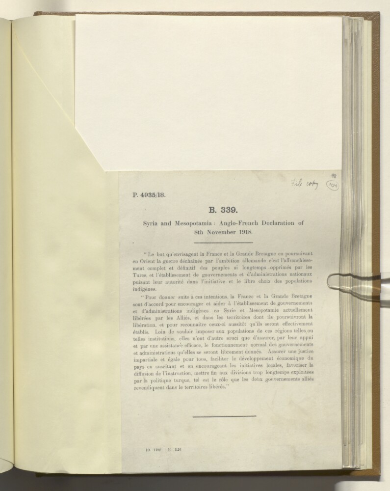
Abstract: This file consists of a copy of the 'Syria and Mesopotamia: Anglo-French declaration of 8 November 1918'. It is written in French and expresses the wishes of Britain and France to liberate those they feel have been 'too long oppressed by the Turks' by helping them to install functional governments and 'indigenous administrations', and by contributing to their economic development.Physical description: Foliation: the foliation sequence for this description commences at f 104, and terminates at f 104, as it is part of a larger physical volume; these numbers are written in pencil, are circled, and are located in the top right corner of the recto side of each folio. An additional foliation sequence is present in parallel; these numbers are also written in pencil, but are not circled.