Abstract: This file contains a letter by Brigadier-General Charles Henry Uvedale Price in which he forwards a report on a visit to the Idrissi [Idrisi] Saiyid by Major Charles Richard Bradshaw, General Staff, Aden, to the Secretary to Government, Political Department, Bombay. The documents discuss the campaign in South Arabia during the First World War which involved fighting between the Arab-Turk army and the Idrissi and his forces and largely centred around the port city of Aden. The correspondence details the need for the British to supply the Idrissi with suitable ammunition if he is to have any chance of defeating the invading Turkish army.Physical description: Foliation: the foliation sequence for this description commences at f 33, and terminates at f 35, as it is part of a larger physical volume; these numbers are written in pencil, are circled, and are located in the top right corner of the recto side of each folio. An additional foliation sequence is present in parallel; these numbers are also written in pencil, but are not circled.
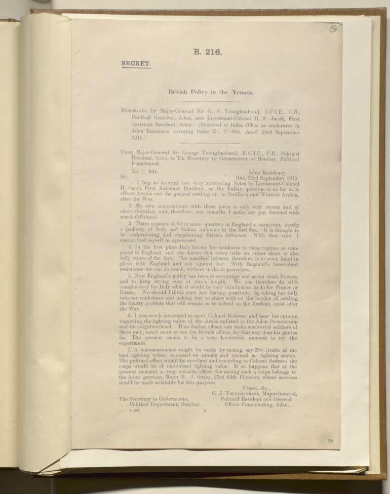
Abstract: The file contains an introduction by Major-General Sir George John Younghusband, Political Resident, Aden, introducing two memoranda written by Lieutenant Harold Fenton Jacob, First Assistant Resident, Aden. They are addressed to the Secretary to the Government of Bombay, Political Department, it concerns Italian influence in the Red Sea, and how it is affecting Arabia after the Second World War.Enclosure No. 1 'Memorandum on the employment by Italians at Mogadiscio of Askaris from Arabia', dated 8 September 1915, Aden. It concerns an interview held with Colonel Bodrero of the Italian Benadir Colonial Service on the training of Arabs, and their fighting value.Enclosure No. 2 'Memorandum on the Political Policy of our Hinterland', dated 9 September 1915, Aden. It outlines what will happen politically if Turkey was to retire from Yemen, these being: the Imam of Sanaa [Ṣanʻā'] shifting his headquarters southwards, and taking hold of relinquished areas; conflicting interests of Imam and Idrisi Saiyid of Sabia; and amendments to British policy on expansion and previous agreements with Idrisi and Ibn Nasir Mukbil. Jacob also puts forward his own opinions of the rulers and the Arabs; and suggests future actions such as a strategic railway, raising levies, educating the sons of chieftains, and introducing medical missions.Physical description: Foliation: the foliation sequence for this description commences at f 96, and terminates at f 99, as it is part of a larger physical volume; these numbers are written in pencil, are circled, and are located in the top right corner of the recto side of each folio. An additional foliation sequence is present in parallel between ff 96-99; these numbers are also written in pencil, but are not circled. Pagination: the file also contains an original printed pagination sequence.
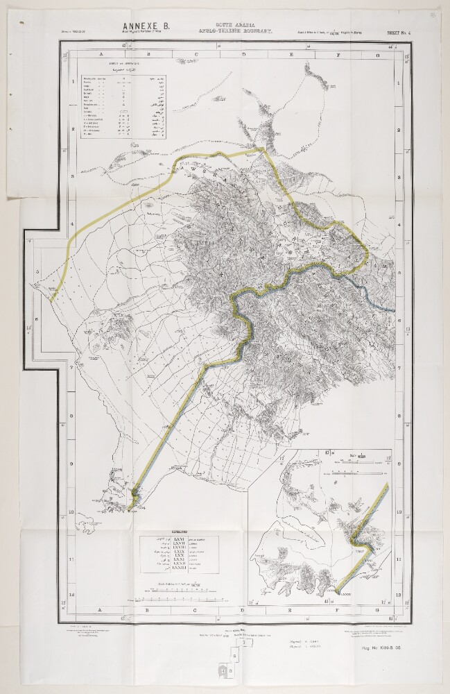
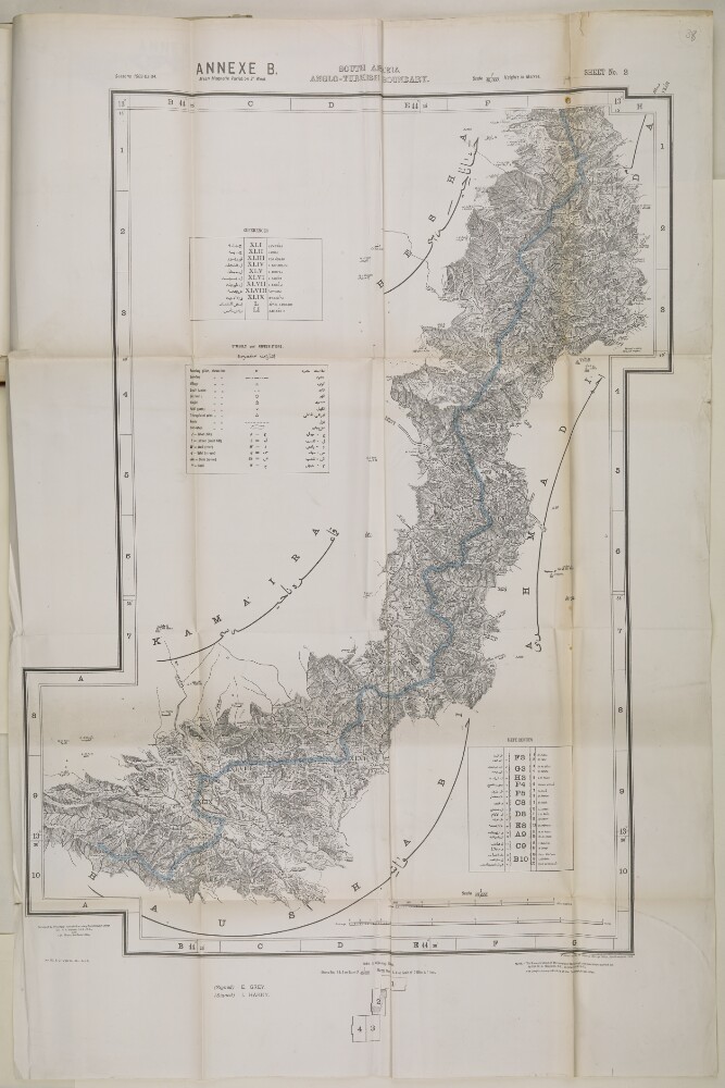
Abstract: This map is enclosed in a printed copy of the Anglo-Ottoman Convention of 1914. It depicts the line of demarcation of the boundary determined to separate the Yemen from the territory of the nine cantons of Aden (shown in blue). Also included is an enlarged inset map of the Shekh Sa'id [Ra’s Shaykh Sa‘īd] peninsula.The map's borders are lettered and numbered. Areas on the map are marked with Roman numerals and listed in a table of references. Another table provides a key to symbols and abbreviations. Place names and symbol and abbreviation references are printed in English and Arabic. As well as boundaries the map indicates hydrology, settlements, cultivation and roads. Relief is shown by contours and spot heights.This map is sheet four of four. Also included is an index to adjoining sheets and a note on the survey's sources.Small printed text near below the map states that it was surveyed by the Anglo-Turkish Boundary Commission, under Colonel Robert Alexander Wahab and Colonel Mustapha Remzi Bey, and printed at the Ordnance Survey Office, Southampton, 1914. The map also states the names of the British and Ottoman signatories of the Anglo-Ottoman Convention: E Grey [Edward Grey, Secretary of State for Foreign Affairs] and I Hakky [Ibrahim Hakki Pasha, Ottoman representative].Physical description: Materials: Printed on paper.Dimensions: 935 x 621mm, on sheet 1081 x 689mm.
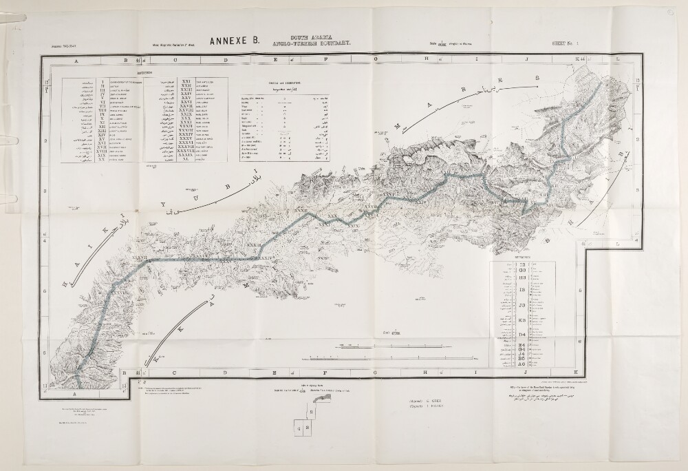
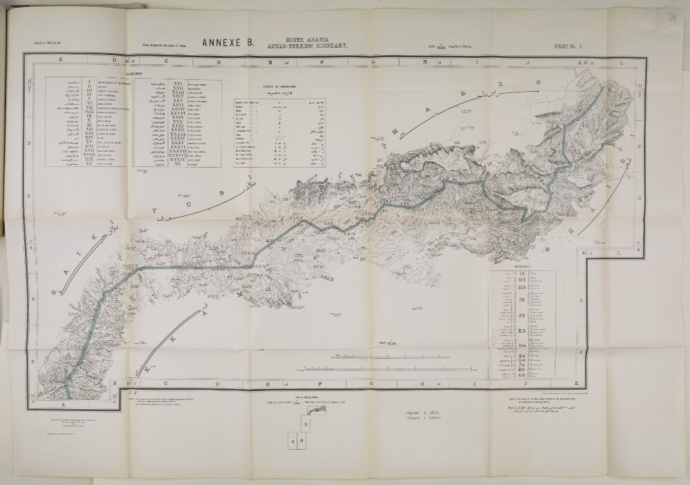
Abstract: This map is enclosed in a printed copy of the Anglo-Ottoman Convention of 1914. It depicts the line of demarcation of the boundary determined to separate the Yemen from the territory of the nine cantons of Aden (shown in blue).The map's borders are lettered and numbered and are used to reference places in an accompanying table. Areas on the map are marked with Roman numerals and are listed in a second table of references. A third table provides a key to symbols and abbreviations. Place names and symbol and abbreviation references are printed in English and Arabic. The map also indicates hydrology, settlements, cultivation and roads. Relief is shown by contours and spot heights.This map is sheet one of four. Also included is an index to adjoining sheets and a note on the survey's sources.Small printed text near below the map states that it was surveyed by the Anglo-Turkish Boundary Commission, under Colonel Robert Alexander Wahab and Colonel Mustapha Remzi Bey, and printed at the Ordnance Survey Office, Southampton, 1914. The map also states the names of the British and Ottoman signatories of the Anglo-Ottoman Convention: E Grey [Edward Grey, Secretary of State for Foreign Affairs] and I Hakky [Ibrahim Hakki Pasha, Ottoman representative].Physical description: Materials: Printed on paper.Dimensions: 485 x 865mm, on sheet 680 x 980mm.
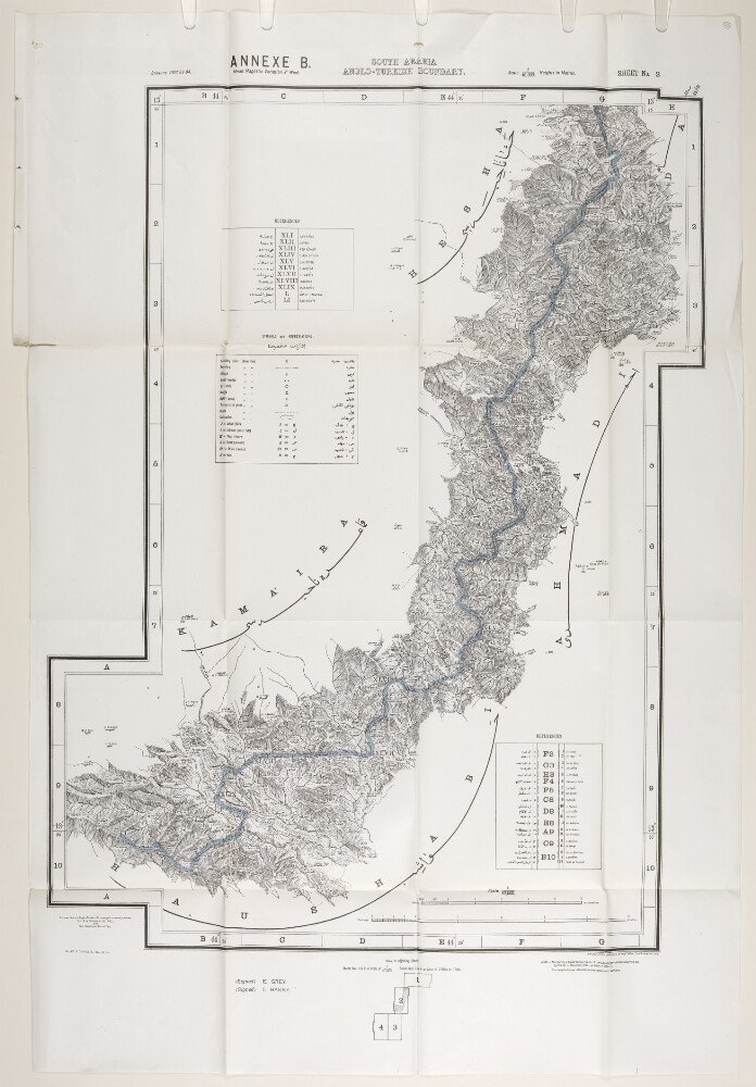
Abstract: This map is enclosed in a printed copy of the Anglo-Ottoman Convention of 1914. It depicts the line of demarcation of the boundary determined to separate the Yemen from the territory of the nine cantons of Aden (shown in blue).The map's borders are lettered and numbered and are used to reference places in an accompanying table. Areas on the map are marked with Roman numerals and are listed in a second table of references. A third table provides a key to symbols and abbreviations. Place names and symbol and abbreviation references are printed in English and Arabic. The map also indicates hydrology, settlements, cultivation and roads. Relief is shown by contours and spot heights.This map is sheet two of four. Also included is an index to adjoining sheets and a note on the survey's sources.Small printed text near below the map states that it was surveyed by the Anglo-Turkish Boundary Commission, under Colonel Robert Alexander Wahab and Colonel Mustapha Remzi Bey, and printed at the Ordnance Survey Office, Southampton, 1914. The map also states the names of the British and Ottoman signatories of the Anglo-Ottoman Convention: E Grey [Edward Grey, Secretary of State for Foreign Affairs] and I Hakky [Ibrahim Hakki Pasha, Ottoman representative].Physical description: Materials: Printed on paper.Dimensions: 803 x 554mm, on sheet 989 x 670mm.
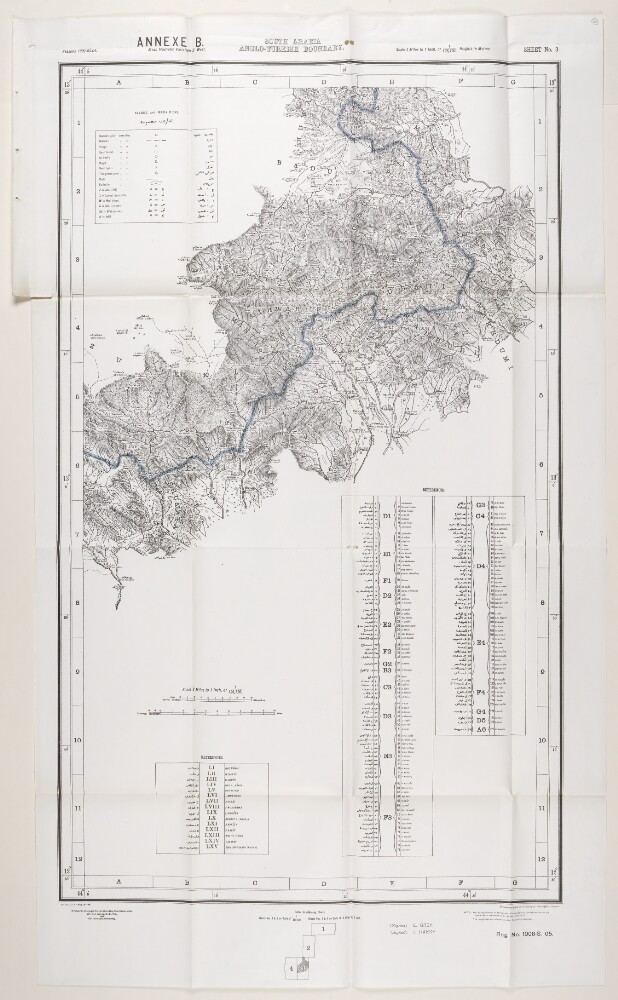
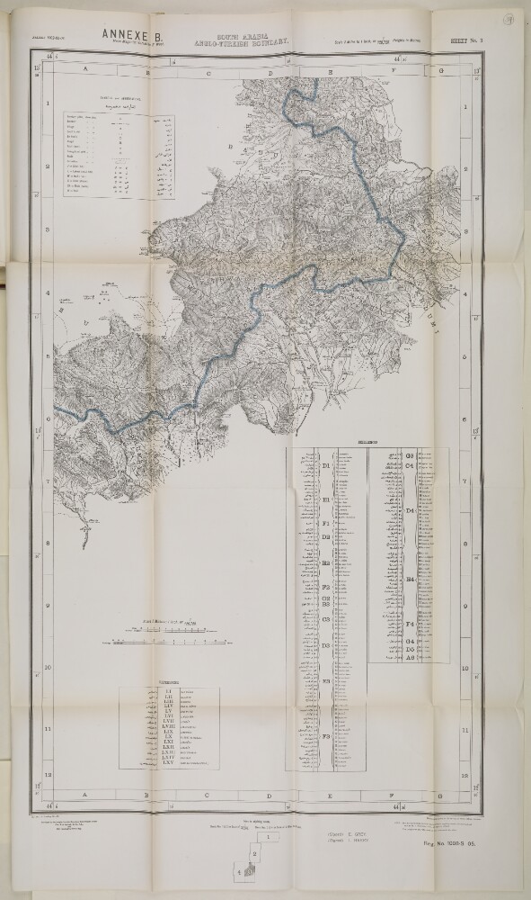
Abstract: This map is enclosed in a printed copy of the Anglo-Ottoman Convention of 1914. It depicts the line of demarcation of the boundary determined to separate the Yemen from the territory of the nine cantons of Aden (shown in blue).The map's borders are lettered and numbered and are used to reference places in an accompanying table. Areas on the map are marked with Roman numerals and are listed in a second table of references. A third table provides a key to symbols and abbreviations. Place names and symbol and abbreviation references are printed in English and Arabic. The map also indicates hydrology, settlements, cultivation and roads. Relief is shown by contours and spot heights.This map is sheet three of four. Also included is an index to adjoining sheets and a note on the survey's sources.Small printed text near below the map states that it was surveyed by the Anglo-Turkish Boundary Commission, under Colonel Robert Alexander Wahab and Colonel Mustapha Remzi Bey, and heliozincographed at the Survey of India Offices, Calcutta. The map also states the names of the British and Ottoman signatories of the Anglo-Ottoman Convention: E Grey [Edward Grey, Secretary of State for Foreign Affairs] and I Hakky [Ibrahim Hakki Pasha, Ottoman representative].Physical description: Materials: Printed on paper.Dimensions: 936 x 560mm, on sheet 1081 x 633mm.
Abstract: This file contains correspondence regarding the Saudi-Yemen War of 1934 covering its outbreak, key developments and its cessation with the Taif Treaty. The majority of this correspondence consists of updates on the war that were sent from the British Legation in Jeddah to Britain's various Political Agencies in the Gulf including the Political Agency in Muscat.In addition to correspondence, the file contains the following:Translated extracts of articles about the war from the Saudi newspapers
Umm al-Qura(folio 18) and
Sawt al-Hijaz(folios 23-24)'Annotated Summary of the Saudi-Yemen Peace Treaty concluded at Taif on the 6th Safar (equivalent to the 20th May 1934, but no European date is given)' (folios 47-52)'Treaty of Islamic Friendship and Brotherhood, between the Saudi Arab Kingdom and the Kingdom of Yemen [The Taif Treaty]' (folios 56-68)'Arbitration Covenant between the Saudi Arab Kingdom and the Kingdom of Yemen' (folios 69-76).Physical description: Foliation: the main foliation sequence (used for referencing) commences at the front cover with 1, and terminates at the inside back cover with 87; these numbers are written in pencil, are circled, and are located in the top right corner of the recto side of each folio. An additional foliation sequence is present in parallel; these numbers are also written in pencil, but are not circled.
Abstract: The
Who's Who in Aden and Western Arabiacomprises a biographical dictionary of individuals connected with the fall of the Sultanate of Lahej [Laḩij] to Ottoman forces in July 1915.Most of the individuals are key members of the Subaihi tribe; a breakdown of the sections of the tribe is given on folio 60. In addition, the dictionary includes prominent individuals and leaders of other Arab tribes; key Turkish military personnel; and individuals being held as prisoners of war including British military personnel.The volume was published in Calcutta by the Superintendent Government Printing, India.Physical description: Foliation: the foliation sequence commences at the front cover with 1 and terminates at the back cover with 67; these numbers are written in pencil, are circled, and are located in the top right corner of the recto side of each folio. Pagination: the file also contains an original printed pagination sequence.
Abstract: Imprint:Printed at the Ordnance Survey Office, Southampton, 1914. Surveyed by the Anglo-Turkish Boundary Commission under Colonel R.A. Wahab, C.I.E., R.E. and Colonel Mustapha Remzi Bey. Signed by Sir Edward Grey and Ibrahim Hakki Pasha.Distinctive Features:Relief shown by contours and spot heights.Map issued as an Annex B to Anglo-Ottoman Convention of 3 June 1914. The line of demarcation of the boundary determined to separate the Yemen from the territory of the nine cantons of Aden shown in blue. Areas marked with Roman numerals are listed in table of reference and described in main body of the document.Map's borders are lettered and numbered for reference with tables and a key to symbols and abbreviations in both English and Arabic. Includes index to adjoining sheets and a note on the survey’s sources.Physical description: Dimensions:676 x 590 mm, on sheet 988 x 656 mm
Abstract: Imprint:Printed at the Ordnance Survey Office, Southampton, 1914. Surveyed by the Anglo-Turkish Boundary Commission under Colonel R.A. Wahab, C.I.E., R.E. and Colonel Mustapha Remzi Bey. Signed by Sir Edward Grey and Ibrahim Hakki Pasha.Distinctive Features:Relief shown by contours and spot heights.Map issued as an Annex B to Anglo-Ottoman Convention of 3 June 1914. The line of demarcation of the boundary determined to separate the Yemen from the territory of the nine cantons of Aden shown in blue. Areas marked with Roman numerals are listed in table of reference and described in main body of the document.Map's borders are lettered and numbered for reference with tables and a key to symbols and abbreviations in both English and Arabic. Includes index to adjoining sheets and a note on the survey’s sources.Physical description: Dimensions:485 x 865 mm, on sheet 680 x 980 mm
Abstract: Imprint:Heliozincographed at the Survey of India Offices, Calcutta. Surveyed by the Anglo-Turkish Boundary Commission under Colonel R.A. Wahab, C.I.E., R.E. and Colonel Mustapha Remzi Bey. Signed by Sir Edward Grey and Ibrahim Hakki Pasha.Distinctive Features:Relief shown by contours and spot heights.Map issued as an Annex B to Anglo-Ottoman Convention of 3 June 1914. The line of demarcation of the boundary determined to separate the Yemen from the territory of the nine cantons of Aden shown in blue. Areas marked with Roman numerals are listed in table of reference and described in main body of the document.Map's borders are lettered and numbered for reference with tables and a key to symbols and abbreviations in both English and Arabic. Includes index to adjoining sheets and a note on the survey’s sources.Physical description: Dimensions:875 x 495 mm, on sheet 1080 x 634 mm