1 - 11 of 11
Number of results to display per page
Search Results
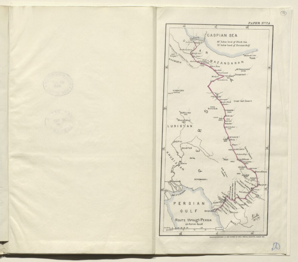
1. ‘Route through Persia on horse back’
- Description:
- Abstract: Map of eastern Persia [Iran] marked paper no. 7A, and showing the route from Rasht to Bushire taken on horseback by Colonel August Le Messurier of the Bombay Engineers. The map indicates: the route taken, shown as a solid red line; major towns and cities on the route, with their elevations given in feet; the coastlines of the Caspian Sea and Persian Gulf; rivers. All the place names on the map have pencil ticks alongside them. The map’s scale is expressed in miles and farsakhs.The map bears a printed signature (illegible) in the bottom right corner, dated 28 November 1887. Under the map is the statement: ‘Photozincographed at the Survey of India Office, Calcutta, March 1888.’Physical description: Dimensions:283 x 145 mm, on sheet 334 x 375 mm.Materials:Ink on paper.
2. 'IRAQ AND THE PERSIAN GULF'
- Description:
- Abstract: The volume is titled Iraq and the Persian Gulf(London: Naval Intelligence Division, 1944).The report contains preliminary remarks by the Director of Naval Intelligence, 1942 (John Henry Godfrey) and the Director of Naval Intelligence, 1944 (E G N Rushbrook).There then follows thirteen chapters:I. Introduction.II. Geology and description of the land.III. Coasts of the Persian Gulf.IV. Climate, vegetation and fauna.V. History.VI. People.VII. Distribution of the people.VIII. Administration and public life.IX. Public health and disease.X. Irrigation, agriculture, and minor industry.XI. Currency, finance, commerce and oil.XII. Ports and inland towns.XIII. Communications.Appendices: stratigraphy; meteorological tables; ten historical sites, chronological table; weights and measures; authorship, authorities and maps.There follows a section listing 105 text figures and maps and a section listing over 200 illustrations.Physical description: Foliation: the foliation sequence (used for referencing) commences at the front cover with 1, and terminates at the inside back cover with 430; these numbers are written in pencil, are circled, and are located in the top right corner of the recto side of each folio.Pagination: the file also contains an original printed pagination sequence.
3. 'REPORTS ON MINOR OPERATONS IN SOUTH PERSIA UNDER Brigadier-General Sir P. M. Sykes, K.C.I.E, C.M.G., from May to July 1918. GENERAL STAFF INDIA'
- Description:
- Abstract: The volume consists of reports on minor military operations in 'South Persia' contained in a despatch from the Inspector General, South Persia Rifles (Percy Molesworth Sykes) to the Chief of the General Staff, Army Headquarters, Simla. The reports recount operations against Labu Muhammadis, Chehar Radis and other 'robber tribes' of 'Northern Fars' and against the 'Saulat-ud-Daulah', Il Khani of the Qashqais', and 'Nasr-I-Divan Kalantar of Kazarun'. Many of the reports included were by the Deputy Inspector General, South Persia Rifles (Colonel Ernest Frederick Orton).There follow individual reports from commanding officers detailing the units involved, topography of the land on which the military operations took place, the villages and tribes attacked, description of military operation, tables of operational logistics and casualties sustained on both sides.The volume contains 17 maps and plans of the towns and villages attacked in the operations, giving such information as relief, settlement, hydrology, lines of communication and progress of battle:'Plan of villages - CHAH-HAQ and MIAN DASHT, CHAHAR-RAHI PUNITIVE EXPEDITION. APRIL, 1918' (folio 4)'ACTION OF DEH SHAIKH. 25th May 1918.' (folio 15)'Fight at DEH SHAIKH Map (17. C. B. 2.4.6) 25th May 1918.' (folio 17)'ACTION OF DEH SHAIKH. 25th May 1918. Decisive attack from Gardaneh Sagavi Kutal, 3 p.m.' (folio 18)'PLAN OF NEIGHBOURHOOD SHIRAZ' (folio 23)'AFIFABAD POST As when occupied by detachment on 9-6-18.' (folio 24)'Action of BULVARDI, near SHIRAZ. June 27th 1918.' (folio 30)'Action at CHINARINAZ (10th May 1918)' (folio 39)'ACTION NEAR HERAT-I-KHURREH' (11th May 1918) GUDAR-I-PIRZAD.' (folio 41)'PLAN SHEWING HILLS SOUTH OF ZIARAT VILLAGE.' (folio 43)'ACTION OF ZIARAT, SARCHAHAN VALLEY; 13-5-1918. From Khunsar River (folio 44)'ACTION OF KUH-I-KHAN. Against Charrahis 16-5-1918. From hill 1200 feet above , and N. of valley; looking South.' (folio 47)'ACTION OF CHINAR RAHDAR. 7th July 1918. Situation at 5-30 a. m., 7th July 1918.' (folio 61)'SKETCH MAP OF ABADEH.' (folio 74)'Sketch Map to Illustrate OPERATIONS TOWARDS FIRUZABAD (July 1918.)' (folio 82)'PERSIA. INDIA AND ADJACENT COUNTRIES. SHEET NO. 17' (folio 84)'ACTION NEAR FIRUZABAD. [23rd-24th July 1918].' (folio 85)Physical description: Foliation: the foliation sequence for this description commences at the front cover with 1, and terminates at the inside back cover with 87; these numbers are written in pencil, are circled, and are located in the top right corner of the recto side of each folio. Pagination: the volume also contains an original printed pagination sequence.
4. 'REPORT on the Working of the Line of Communication AND ON THE Withdrawal of the British Military Mission IN EAST PERSIA, 1919-20. GENERAL STAFF INDIA.
- Description:
- Abstract: The volume is titled Report on the Working of the Line of Communication and on the Withdrawal of the British Military Mission in East Persia, General Staff India. The volume is marked confidential and was printed in Delhi by Superintendent Government Printing, India, in 1921.The report is from the General Officer Commanding, Baluchistan District to the Chief of the General Staff; the report contains preliminary remarks on 'The withdrawal of the troops of the British Military Mission at and beyond Meshed, and of the Lines of Communication'. There follows the substantive report from the Inspector-General of Communications, East Persia, Duzdap to the General Staff, Baluchistan District, Quetta. This report is divided into two parts:Part I - 'A brief report on the working and organization of the Line of Communications, East Persia, in April 1920'Part II - 'The withdrawal' which has the following sub-sections: general; supply and transport services (including some special points for consideration); medical; ordnance; works; posts and telegraphs; vetinary.The report is accompanied by nine maps:'APPENDIX 1. SKETCH MAP SHOWING POSITION OF POST AND COMBINED OFFICES IN EAST PERSIA' (folio 10)'APPENDIX 1. L. OF C.E.P. INTELLIGENCE SYSTEM' (folio 12)'APPENDIX 2. AREA ON THE EAST PERSIA L. OF C. COMMON TO RAIDING (folio 15)'APPENDIX 1. GRAPHIC MAP ILLUSTRATING THE NORMAL SOURCES FROM WHICH THE TROOPS IN EAST PERSIA WERE SUPPLIED AND THE CONTINUOUS MOVEMENTS BY WHICH THE SUPPLIES WERE NORMALLY DISTRIBUTED TO THE FORCE AT MESHED AND TO THE GARRISONS OF POSTS ON L. OF C.' (folio 18)'APPENDIX 1. LINES OF COMMUNICATION EAST PERSIA' (folio 33)'APPENDIX 3. DIAGRAM SHOWING POSITIONS OF TELEPHONE, TELEGRAPH AND COMBINED OFFICES IN EAST PERSIA' (folio 35)'COLUMNS AND CONVOYS WOKRING IN CONNECTION WITH WITHDRAWAL FROM EAST PERSIA' (folio 55)'DAYS AFTER ZERO' (folio 62)'PLAN showing ORGANIZATION OF LINE OF COMMUNICATIONS (ADMINISTRATIVE AND DEFENCE TROOPS) (folio 77)Physical description: Foliation: the foliation sequence for this description commences at the front cover with 1, and terminates at the inside back cover with 78; these numbers are written in pencil, are circled, and are located in the top right corner of the recto side of each folio.Pagination: the volume also contains an original printed pagination sequence.
5. 'Military report on Tehran and adjacent Provinces of North-West Persia (including the Caspian Littoral)'
- Description:
- Abstract: Military report compiled by Captain LS Fortescue of the General Staff of the Mesopotamia Expeditionary Force and printed in Calcutta at the Superintendent Government Printing, India, 1922.The volume begins with a statement defining the geographical area covered by the report. The report is divided into ten chapters, plus appendices, each concerning a different subject, as follows:Chapter 1: HistoryChapter 2: GeographyChapter 3: Climate, Water, Medical and AviationChapter 4: EthnographyChapter 5: Administration (including a table of provinces with administrative details (folios 123-30)Chapter 6: Armed Forces of the Persian GovernmentChapter 7: Economic ResourcesChapter 8: TribesChapter 9: PersonalitiesChapter 10: CommunicationsAppendices: Glossary of terms; Weights, measures and coinage; Bibliography; Historical sketch (Chapter 1) continued from June 1920 to the end of 1921At the back of the volume (folio 302) is a map to illustrate the report.Physical description: Foliation: the foliation sequence (used for referencing) commences at the front cover with 1, and terminates at the inside back cover with 303; these numbers are written in pencil, are circled, and are located in the top right corner of the recto side of each folio.Pagination: the file also contains an original printed pagination sequence.
6. 'Military Report on The Anglo-Iranian Oil Company's (South Iranian) Oilfield Area'
- Description:
- Abstract: Military report compiled at the General Staff, Army Headquarters, India, and printed in Simla by The Manager, Government of India Press, 1940.The volume begins with a preface (folio 3) in which notes on authorities consulted in compiling the report are given. The rest of the report is divided into nine chapters (I-IX), plus appendices, each covering a different subject, as follows:Chapter I: General Description of the AreaChapter II: ClimateChapter III: PopulationChapter IV: Base PortsChapter V: Lines of Communication and Transportation FacilitiesChapter VI: Signal CommunicationsChapter VII: Economic Resources and SuppliesChapter VIII: Engineer and Ordnance FacilitiesChapter IX: Medical FacilitiesAppendicesIn a pocket at the back of the volume are the following maps and charts:Abadan and Bawarda (map) (folio 64)Naseri and Ahwaz, showing new bridge (map) (folio 65)Dar-i-Khazineh (map) (folio 66)Diagram of wireless communications (map) (folio 67)Sketch map showing flood water, February-March 1938 (folio 68)Road distance mileage chart (folio 69)Comparative bridge loading table (folio 70)One of the maps listed in the contents is missing: 'Map of A. I. O. C. [Anglo-Iranian Oil Company] Central and Southern areas showing oilfields, pipelines, telephone and telegraph lines'.Physical description: Foliation: the foliation sequence (used for referencing) commences at the front cover with 1, and terminates at the inside back cover with 71; these numbers are written in pencil, are circled, and are located in the top right corner of the recto side of each folio. Pagination: the file also contains an original printed pagination sequence.
7. 'Report on Kurdistan'
- Description:
- Abstract: Confidential report compiled by Hyacinth Louis Rabino. The report was printed in Simla at the Government Monotype Press, 1911.The report is divided into three parts (I-III), as follows:Part I: Geographical and Commercial Notes (folios 6-39) with sections on the province of Kurdistan (including information on cultivation, population, revenue, roads, imports/exports, and the capital, Senna), its tribes (including statistics on population, land, and residences), rivers, and mountains, and appendices comprised of government lists of villages.Part II: History (folios 40-54) with a chart showing the Valis and Provincial Governors of Kurdistan for the years 1169-1905 (folio 41).Part III: Gazetteer of Kurdistan (folios 55-104) arranged alphabetically.At the back of the volume is a glossary (folios 105-06) including notes on the weights used in Kurdistan.Physical description: Foliation: the foliation sequence for this description commences at the front cover with 1, and terminates at the inside back cover with 108; these numbers are written in pencil, are circled, and are located in the top right corner of the recto side of each folio.

8. ‘Gazetteer of Persia, Part III, including Fārs, Lūristān, Arabistān, Khūzistān, Yazd, Karmānshāh, Ardalān, Kurdistān’
- Description:
- Abstract: The third of four volumes comprising a Gazetteer of Persia.The volume, which is marked Confidential, covers Fārs, Lūristān [Lorestān], Arabistān, Khūzistān [Khūzestān], Yazd, Karmānshāh [Kermānshāh], Ardalān, and Kurdistān. The frontispiece states that the volume was revised and updated in April 1885 in the Intelligence Branch of the Quartermaster General’s Department in India, under the orders of Major General Sir Charles Metcalfe Macgregor, Quartermaster-General in India. Publication took place in Calcutta [Kolkata] by the Superintendent of Government Printing, India, in 1885.The following items precede the main body of the gazetteer:a note by Lieutenant-Colonel Mark Sever Bell, Deputy Quartermaster General, Intelligence Branch, requesting inaccuracies, omissions and suggestions for the gazetteer be reported to the Deputy Quartermaster General;a second note, dated 26 November 1885, describing the geographical scope of the four volumes comprising the Gazetteer of Persia, and also making reference to the system of transliteration used (Hunterian) and authorities consulted;a preface, containing a summary of the geographical boundaries of the Gazetteer, a description of the Persian coast of the Persian Gulf, an abridged account of trade in the Persian Gulf for the year 1884, and a description of telegraphs in the regions described by the Gazetteer.The gazetteer includes entries for human settlements (villages, towns and cities), geographic regions, tribes, significant geographic features (such as rivers, canals, mountains, valleys, passes), and halting places on established routes. Figures for latitude, longitude and elevation are indicated where known.Entries for human settlements provide population figures, water sources, location relative to other landmarks, climate. Entries for larger towns and cities can also include tabulated meteorological statistics (maximum and minimum temperatures, wind direction, remarks on cloud cover and precipitation), topographical descriptions of fortifications, towers, and other significant constructions, historical summaries, agricultural, industrial and trade activities, government.Entries for tribes indicate the size of the tribe (for example, numbers of men, or horsemen), and the places they inhabit. Entries for larger tribes give tabulated data indicating tribal subdivisions, numbers of families, encampments, summer and winter residences, and other remarks.Information sources are provided at the end of each gazetteer entry, in the form of an author or source’s surname, italicised and bracketed.Physical description: Foliation: the foliation sequence commences at the inside front cover with 1 and terminates at the inside back cover with 341; these numbers are written in pencil, are circled, and are located in the top right corner of the recto side of each folio.Pagination: the volume has two printed pagination systems, the first of which uses Roman numerals and runs from I to XIII (ff 3-10), while the second uses Arabic numerals and runs from 1 to 653 (ff 12-338).
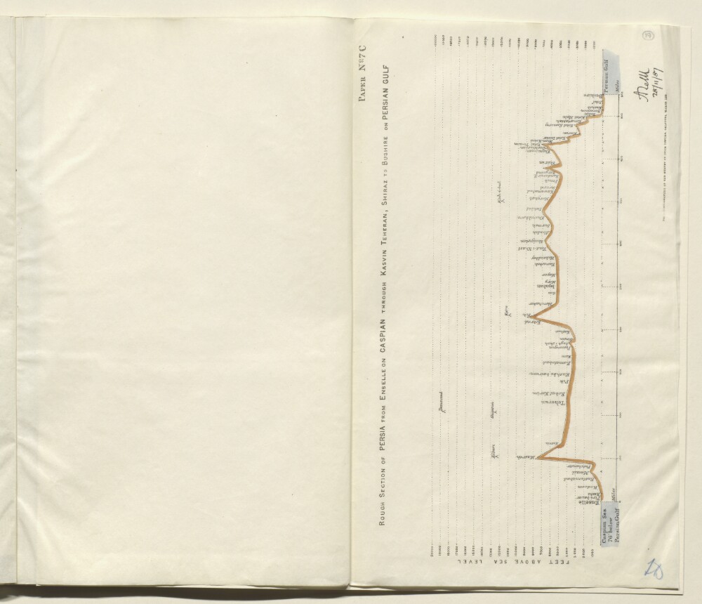
9. ‘Rough Section of Persia from Enselle on Caspian through Kasvin Teheran, Shiraz to Bushire on Persian Gulf’
- Description:
- Abstract: Plan marked paper no. 7C, indicating the height above sea level (expressed in feet) of the route taken from Enselle [Bandar-e Anzalī] near Rasht, to Bushire, via Kasvin [Qazvin], Teheran [Tehran] and Shiraz, by Colonel Augustus Le Messurier of the Bombay Engineers, in 1887. The section is drawn as a solid black and red line, with the Caspian Sea on the left side of the plan, and the Persian Gulf on the right side. Towns and cities along the route are marked on the section. Significant mountains (for example, Demavend [Kūh-e Damāvand]) are also marked on the route.The plan bears a printed signature (illegible) in the bottom right corner, dated 28 November 1887. Under the plan is the statement: ‘Photozincographed at the Survey of India Office, Calcutta, March 1888.’Physical description: Dimensions:393 x 333 mm.Materials:Printed on paper.
10. 'Field notes: Mesopotamia. General Staff, India. February, 1917.'
- Description:
- Abstract: The file consists of a printed volume regarding the field notes on Mesopotamia. The volume was prepared on behalf of the General Staff, India and printed by the Superintendent Government Printing, India.The volume is divided into the following chapters:I. History.II. Geography.III. Population.IV. Resources.V. Notes on the Turkish Army.VI. Maritime.VII. Administration.VIII Communications; Routes in Mesopotamia.The volume also contains a number of appendices: A. Important personages; B. Table of Distances (in miles); C. Weights, Measures, Currency, Chronology; D. Some notes for officers proceeding to Mesopotamia; Glossary of Terms.Physical description: Foliation: the foliation sequence commences at the inside front cover with 1, and terminates at the inside back cover with 169; these numbers are written in pencil, are circled, and are located in the top right corner of the recto side of each folio.Pagination: the file also contains an original printed pagination sequence.
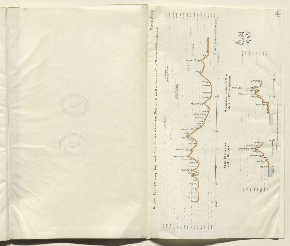
11. Plan showing three sections of the route taken by Colonel Augustus Le Messurier in 1887
- Description:
- Abstract: Plan marked paper no. 7D, indicating the height above sea level (expressed in feet) of three sections of the route taken from Rasht to Bushire, by Colonel Augustus Le Messurier of the Bombay Engineers, in 1887. The three sections are as follows:rough section along the high road from Shiraz to Karman [Kerman], Bampur and Jalk [Jālq], at the edge of the Kharian Desertrough section from the Persian Gulf to Bampurrough section from the Persian Gulf to Jalk and the Kharian DesertThe sections are drawn as solid black and red lines. Towns and cities along the route are marked on the section. Significant mountains are also marked on the route. Varying vertical scales are used for the sections.The plans bear a printed signature (illegible) in the bottom right corner, dated 28 November 1887. Under the plan is the statement: ‘Photozincographed at the Survey of India Office, Calcutta, March 1888.’Physical description: Dimensions:393 x 333 mm.Materials:Printed on paper.