Number of results to display per page
Search Results
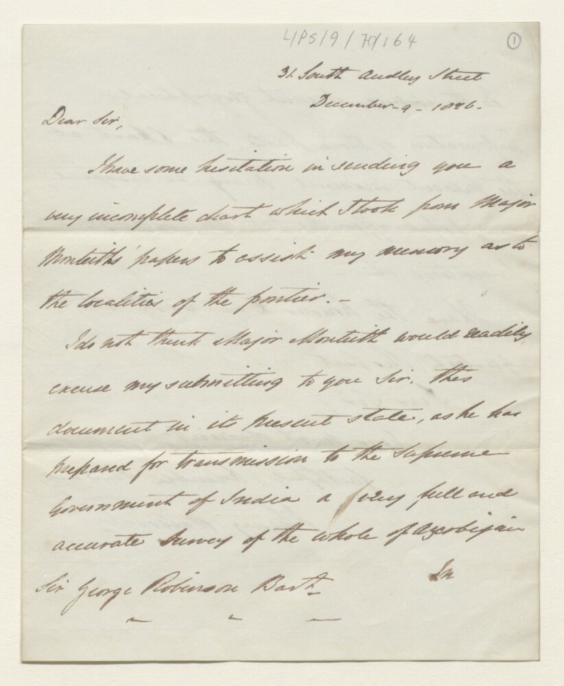
13. Letter from Henry Willock, in London, to the Chairman of the East India Company, Sir George Abercrombie Robinson
- Description:
- Abstract: Letter from the former HM Chargé d’Affaires to Persia [Iran], Henry Willock, in London, to the Chairman of the East India Company, Sir George Abercrombie Robinson, of 9 December 1826. The letter originally forwarded a chart of the frontier between Russia and Persia by Major William Monteith (not included in this item), which Willock indicates is ‘very incomplete’.Physical description: 1 item (2 folios)

14. PZ 6642/35 Supply of certain War Office and Survey of India maps to the government of Iraq for reprinting in Arabic
- Description:
- Abstract: The file consists of correspondence regarding the supply of certain War Office and Survey of India maps to the Government of Iraq for reprinting in Arabic. It includes a list of maps to be reprinted.The main correspondents include: the Iraqi Ministry for Foreign Affairs, Bagdad [Baghdad]; the British Embassy, Bagdad; HM Ambassador, Bagdad; the Foreign Secretary to the Government of India; the War Office; and the Foreign Office.Physical description: Foliation: the foliation sequence for this description commences at f 1, and terminates at f 25, it is the third file in a larger physical volume, each file has its own foliation sequence; these numbers are written in pencil, and are located in the top right corner of the recto side of each folio.
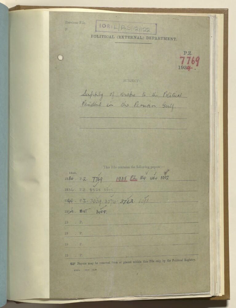
15. PZ 7769/1934 'Supply of maps to the political resident in the Persian Gulf'
- Description:
- Abstract: The file contains correspondence, notes, supply notes, and an air consignment note, relating to the supply of maps to the Political Resident in the Persian Gulf.It includes correspondence between Trenchard Craven William Fowle, Political Resident in the Persian Gulf, and John Gilbert Laithwaite, India Office, and between Laithwaite and Arthur Robert Hinks and others at the Royal Geographical Society, regarding Fowle’s requests to be sent copies of the map in Bertram Thomas’s ‘Arabia Felix’, and the map in Philby’s ‘Rub al Khali’. It also includes correspondence between Fowle and M J Clauson, India Office, and between Clauson and Hinks, concerning Fowle’s request for three additional copies of Bertram Thomas’s map to be sent to himself at the Residency, Bushire, and to the Political Agents at Bahrain and Muscat. This correspondence is dated 27 November 1934 to 28 December 1936.Correspondence and other papers dated 27 May 1940 to 9 May 1946, relate to the supply of a complete set of the charts of the Persian Gulf, up to and including the Shatt al Arab, and copies of replacements of charts which may be issued from time to time, to Charles Geoffrey Prior, Political Resident in the Persian Gulf. These papers include a telegram from Prior to the Secretary of State for India, and correspondence between J P Gibson, India Office, and the Superintendent of the Admiralty Charts Supplies Division.The file does not contain any papers for the period between 29 December 1936 to 26 May 1940.Physical description: Foliation: the foliation sequence (used for referencing) commences at the first folio with 1 and terminates at the last folio with 38; these numbers are written in pencil, and are located in the top right corner of the recto side of each folio.

16. Pol Ext 8579/49 'Declassification of maps of Muscat: request from Persian Gulf Residency, Bahrain'
- Description:
- Abstract: This file contains correspondence relating to the declassification of maps detailing Muscat, created by the Government of India, which were requested by the Persian Gulf Residency in Bahrain . The main correspondents are the Bahrain Political Agency, the Commonwealth Relations Office and the Foreign Office.Physical description: Foliation: the foliation sequence (used for referencing) commences at the front cover with 1, and terminates at the inside back cover with 8, these numbers are written in pencil, are circled, and are located in the top right corner of the recto side of each folio.
17. General No. 24 of 1874, Forwarding a Copy of a Letter from the Political Resident in the Persian Gulf, Together with a Map of the Town and Peninsula of Bushire, Prepared by Lieutenant Stiffe, Formerly of the Indian Navy
- Description:
- Abstract: This item consists of copies of a General Despatch from the Government of India Foreign Department to the Secretary of State for India, dated 4 August 1874 and received by the India Office Political Department on 31 August 1874, forwarding a copy of a letter from the Political Resident in the Persian Gulf, together with a map of the town and peninsula of Bushire [Būshehr] prepared by Lieutenant Arthur William Stiffe, formerly of the Indian Navy (the map is not included in this item). The despatch adds that the Political Resident has been asked to convey the acknowledgments of the Government of India to Lieutenant Stiffe for the map, and that photographs of the map have been made by the Government of India for record.Physical description: Foliation: the foliation sequence for this description (used for referencing) commences at f 29, and terminates at f 30, as it is part of a larger physical volume; these numbers are written in pencil, are circled, and are located in the top right corner of the recto side of each folio. The sequence contains one foliation anomaly, f 29a.

18. Coll 28/100 ‘Persia. Supply to Persian Govt of certain Survey of India maps in the category “For official use only”’
- Description:
- Abstract: Correspondence and papers relating to a request made in January 1937 by the Iranian Government to the British Government, for maps of Iran from the Survey of India, currently marked as being for official use only. Much of the correspondence is between the Foreign Office and India Office/Government of India, and discusses: precedents to the request (specifically, a request for Survey of India maps from the Afghan Government in 1936); the Government of India’s refusal of the Iranian Government’s request in August 1937, due to the continued military importance of the maps in question; a long delay in responding to the Iranian Government’s request, which remained unanswered until November 1938.The file includes a divider, which gives a list of correspondence references contained in the file by year. This is placed at the back of the correspondence.Physical description: Foliation: the foliation sequence (used for referencing) commences at the front cover with 1, and terminates at the inside back cover with 30; these numbers are written in pencil, are circled, and are located in the top right corner of the recto side of each folio.
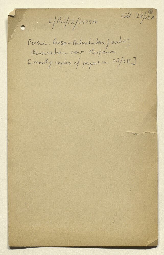
19. Coll 28/28 ‘Persia. Perso-Baluchistan Frontier. Demarcation near Mirjawa.’
- Description:
- Abstract: Correspondence, memoranda, maps and other papers relating to the establishment of a precise position of the frontier between Persia [Iran], British Baluchistan [in present-day Pakistan], and Afghanistan, arising in response to the proposed transfer to Persian ownership of the Mirjawa [Mīrjāveh] to Duzdap [Zahedan] stretch of the North Western Railway, and territorial claims made by the Khan of Kalat, Mir Mohammad Azam Jan Khan, and the Persian Government. The volume’s correspondents include: Foreign Office and India Office officials; the British Legation at Tehran (Reginald Hervey Hoare; Charles Dodd); the Government of India (Francis Verner Wylie); the Agent to Governor-General and Chief Commissioner for Baluchistan (Alexander Norman Ley Cater); the British Consul for Sīstān and Kain [Ka’īn] (Clive Kirkpatrick Daly).The correspondence covers:The historical basis for negotiations, being surveys carried out in the 1870s, and a demarcation agreement concluded on 24 March 1896 by Colonel Thomas Hungerford Holdich, later referred to as the Holdich Line. Papers include correspondence from the 1930s in response to uncertainties about the precise position of the line (including extracts of the agreement in Persian), and copies of correspondence from 1895-1896 relating to the conclusion of Holdich’s agreement.Arrangements in 1932 for a joint British and Persian survey party to map the frontier, with Captain Guy Bomford of the Survey of India leading the British party. The results of Bomford’s survey are summarised in a copy of a secret letter, dated 9 June 1932, with accompanying maps (ff 113-119).Physical description: Foliation: the foliation sequence (used for referencing) commences at the first folio with 1 and terminates at the last folio with 321; these numbers are written in pencil, are circled, and are located in the top right corner of the recto side of each folio. The foliation sequence does not include the front and back covers, nor does it include the two leading and two ending flyleaves.A previous foliation sequence, which is also circled, has been superseded and therefore crossed out.
20. Coll 28/28A ‘Persia: Perso-Baluchistan frontier; demarcation near Mirjawa [mostly copies of papers on 28/28]’
- Description:
- Abstract: Photographic reproductions of letters, memoranda, printed copies of correspondence and maps, relating to the demarcation of the border between Persia [Iran] and British Baluchistan (in present-day Pakistan) around the town of Mirjawa [Mīrjāveh]. The majority of the file’s papers are duplicates of material in the file Coll 28/28 ‘Persia. Perso-Baluchistan Frontier. Demarcation near Mirjawa.’ (IOR/L/PS/12/3425).Correspondence dating between 1924 and 1935 comprises the first part of the file (ff 2-153). The second part of the file is preceded by a cover slip attached to folio 154, which reads: ‘Collection ‘B’’. Papers in this part of the file (ff 154-286) comprise copies of correspondence dating between 1871 and 1912. Three of the file’s thirteen maps (f 223, f 224, f 242) are not duplicates of maps included IOR/L/PS/12/3425.Physical description: Foliation: the foliation sequence (used for referencing) commences at the front cover with 1, and terminates at the last folio with 286; these numbers are written in pencil, are circled, and are located in the top right corner of the recto side of each folio.

21. Coll 29/16 'Kermanshah: office allowance; miscellaneous charges'
- Description:
- Abstract: The file concerns the British Consulate at Kermanshah.The file covers office allowance grants and supply of maps.The file is composed solely of internal correspondence between the Foreign Office, the India Office, the Government of India, and the British Consulates at Gulhek, and Kermanshah, and the Stationery Office.Physical description: Foliation: the foliation sequence (used for referencing) commences at the front cover with 1, and terminates at the inside back cover with 39; these numbers are written in pencil, are circled, and are located in the top right corner of the recto side of each folio.
22. Coll 6/67(4) 'Boundaries of South Eastern Arabia and Qatar.'
- Description:
- Abstract: This file primarily concerns British policy regarding the eastern and south-eastern boundaries of Saudi Arabia, specifically those bordering Qatar, Abu Dhabi, and Muscat (i.e. the Sultanate of Muscat and Oman).Much of the correspondence relates to British concerns that the boundaries should be demarcated prior to the commencement of any oil prospecting in the area. The file's principal correspondents are the following: His Majesty's Minister at Jedda (Sir Andrew Ryan, succeeded by Sir Reader William Bullard); the Political Resident in the Persian Gulf (Lieutenant-Colonel Trenchard Craven William Fowle); the Political Agent, Bahrain (Lieutenant-Colonel Percy Gordon Loch); the Political Agent, Muscat (Major Ralph Ponsonby Watts); the Secretary of State for the Colonies; the Secretary of State for India; the Secretary of State for Foreign Affairs; officials of the Foreign Office, the Colonial Office, the India Office, and the Admiralty.Matters discussed in the correspondence include the following:Whether the British should press King Ibn Saud [‘Abd al-‘Azīz bin ‘Abd al-Raḥmān bin Fayṣal Āl Sa‘ūd] for a settlement of the outstanding questions relating to the aforementioned boundaries.Sir Andrew Ryan's meeting with Ibn Saud and the Deputy Minister for Saudi Foreign Affairs, Fuad Bey Hamza, in Riyadh, in November 1935.The disputed territories of Jebel Naksh [Khashm an Nakhsh, Qatar] and Khor-al-Odeid [Khawr al ‘Udayd].Whether or not a territorial agreement between Ibn Saud and Qatar was concluded prior to the Anglo-Qatar Treaty of 1916.The intentions of Petroleum Concessions Limited regarding the development of its oil concession in Qatar.The line proposed by the British for the boundary between Saudi Arabia and the Aden Protectorate.The Kuwait blockade.Leading personalities in Oman.Details of Harry St John Bridger Philby's expedition to Shabwa [Shabwah, Yemen].Four meetings held between Sir Reader Bullard, George Rendel (Head of the Foreign Office's Eastern Department), and Ibn Saud, in Jedda, 20-22 March 1937.Also included are the following:Copies of the minutes of meetings of the Committee of Imperial Defence's Standing Official Sub-Committee for Questions Concerning the Middle East.Copies of correspondence dating from 1906, exchanged between the Political Resident in the Persian Gulf (Major Percy Zachariah Cox), the Government of India's Foreign and Political Department, and the Ruler of Abu Dhabi [Shaikh Zayed bin Khalifa Al Nahyan], regarding the latter's claim to Khor-al-Odeid.Several maps and sketch maps depicting the proposed boundaries discussed in the correspondence.The file includes a divider which gives a list of correspondence references contained in the file by year. This is placed at the back of the correspondence (folio 2).Physical description: Foliation: the foliation sequence (used for referencing) commences at the inside front cover with 1, and terminates at the last folio with 421; these numbers are written in pencil, are circled, and are located in the top right corner of the recto side of each folio. A previous foliation sequence, which is also circled, has been superseded and therefore crossed out.
23. Coll 6/62 'Saudi-Arabia: National and provincial boundaries of –'
- Description:
- Abstract: This file concerns a request, made by the Army Headquarters, India, to the British Embassy at Baghdad, for a map of Arabia showing the national and provincial boundaries of Saudi Arabia. The correspondence discusses the difficulties associated with marking out the various boundaries, owing to the fact that many of them are 'the subject of actual or potential controversy'. Also discussed are recommended revisions to the boundaries of Arabia, as shown on a National Geographic Society map of Asia (map not included).Notable correspondents include the following: His Majesty's Minister at Jedda (Sir Andrew Ryan); officials of the Foreign Office, the India Office, the Persian Gulf Political Residency, the British Embassy in Baghdad, and the British Library of Information in New York.In addition to correspondence the file includes the following:A copy of a memorandum dated 18 April 1932, which recounts an interdepartmental conference held at the Colonial Office three days earlier, concerning the submission of the frontiers of the mandated territories (namely the Iraq-Transjordan frontier, the Iraq-Kuwait frontier, and the Palestine-Syria frontier) for approval to the Council of the League of Nations.Two maps: one depicting the Arabian Peninsula and the other showing the eastern portion of the Aden Protectorate.Whilst the date range of the file is 1916-1934, only two items (including the aforementioned memorandum) date from earlier than 1934.The file includes a divider which gives a list of correspondence references contained in the file by year. This is placed at the back of the correspondence (folio 2).Physical description: Foliation: the foliation sequence (used for referencing) commences at the inside front cover with 1, and terminates at the last folio with 60; these numbers are written in pencil, are circled, and are located in the top right corner of the recto side of each folio. A previous foliation sequence, which is also circled, has been superseded and therefore crossed out.
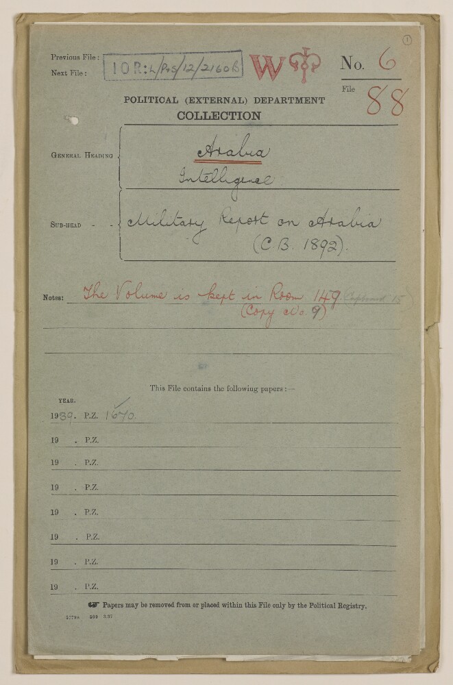
24. Coll 6/88 'Intelligence: Military Report on Arabia (C.B. 1892).'
- Description:
- Abstract: This file consists of two parts. The first part (folios 1-9) begins with a 'state of report' document for an Admiralty Naval Intelligence Division report entitled 'Arabia, Intelligence Report'; the 'state report' concerns the updating of the report in October 1941, and it includes a list of maps, plans and photographs that are contained in the report. There then follows a small amount of correspondence between India Office, War Office, and General Staff (India) officials regarding the supply of an earlier issue of the report, dated 1939.The second part of the file consists of the actual report, entitled 'C.B. 1892 (X) (10/41) Arabia Intelligence Report', dated October 1941, with appended maps, plans and photographs relating to Arabian Peninsula ports. The report is divided into four sections (six sections are listed in the table of contents, which lists sections one and three, most of section two, and one part of section five, as 'not issued', i.e. not printed in this edition of the report).The first section to appear in the report is entitled 'Section II: Strategy and Tactics'; parts 1 and 3-6 of this section have been omitted, leaving part 2, which has the heading 'Possible Lines on which War Plans would be Framed'.The next section, 'Section IV: Geography and Topography', provides an overview of the geography and topography of the Arabian Peninsula, including information about climate, transport facilities (including a table of landing grounds and seaplane anchorages), and communications.The third section, 'Section V: Base Facilities and Maintenance of the Fleet' (from which part one has been omitted), provides a summary of principal commercial dockyards and repair bases, locations for fuel storage, supplies and storage of ammunition, fixed coastal defences, and aircraft.The final section of the report, 'Section VI: Ports, Anchorages and Their Defences', proceeds through a number of Gulf ports in alphabetical order (i.e. Akaba, Bahrain, Doha, Hodeida and Ras Kethib, Jedda, Kamaran, Kuwait, Mukalla, and Muscat), describing each place's port facilities, anchorages and defences, as well as providing other information relating to matters such as government, commerce, water supply, transport and communications.Enclosed with the maps and plans is a symbols chart, which lists some of the symbols used in the maps and plans.Physical description: Foliation: The file is formed of two parts. The foliation sequence (used for referencing) commences at the front cover of the first part at 1 and terminates at the inside back cover of the second part at 65; these numbers are written in pencil, are circled, and are located in the top right corner of the recto side of each folio.
- « Previous
- Next »
- 1
- 2 Current Page, Page 2
- 3