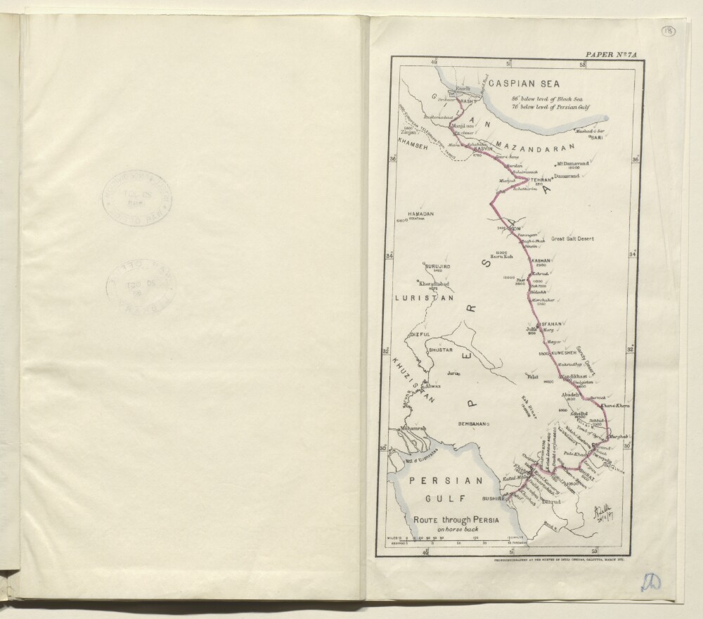
Abstract: Map of eastern Persia [Iran] marked paper no. 7A, and showing the route from Rasht to Bushire taken on horseback by Colonel August Le Messurier of the Bombay Engineers. The map indicates: the route taken, shown as a solid red line; major towns and cities on the route, with their elevations given in feet; the coastlines of the Caspian Sea and Persian Gulf; rivers. All the place names on the map have pencil ticks alongside them. The map’s scale is expressed in miles and farsakhs.The map bears a printed signature (illegible) in the bottom right corner, dated 28 November 1887. Under the map is the statement: ‘Photozincographed at the Survey of India Office, Calcutta, March 1888.’Physical description: Dimensions:283 x 145 mm, on sheet 334 x 375 mm.Materials:Ink on paper.
Abstract: Military report compiled by Captain LS Fortescue of the General Staff of the Mesopotamia Expeditionary Force and printed in Calcutta at the Superintendent Government Printing, India, 1922.The volume begins with a statement defining the geographical area covered by the report. The report is divided into ten chapters, plus appendices, each concerning a different subject, as follows:Chapter 1: HistoryChapter 2: GeographyChapter 3: Climate, Water, Medical and AviationChapter 4: EthnographyChapter 5: Administration (including a table of provinces with administrative details (folios 123-30)Chapter 6: Armed Forces of the Persian GovernmentChapter 7: Economic ResourcesChapter 8: TribesChapter 9: PersonalitiesChapter 10: CommunicationsAppendices: Glossary of terms; Weights, measures and coinage; Bibliography; Historical sketch (Chapter 1) continued from June 1920 to the end of 1921At the back of the volume (folio 302) is a map to illustrate the report.Physical description: Foliation: the foliation sequence (used for referencing) commences at the front cover with 1, and terminates at the inside back cover with 303; these numbers are written in pencil, are circled, and are located in the top right corner of the recto side of each folio.Pagination: the file also contains an original printed pagination sequence.
Abstract: Military report compiled at the General Staff, Army Headquarters, India, and printed in Simla by The Manager, Government of India Press, 1940.The volume begins with a preface (folio 3) in which notes on authorities consulted in compiling the report are given. The rest of the report is divided into nine chapters (I-IX), plus appendices, each covering a different subject, as follows:Chapter I: General Description of the AreaChapter II: ClimateChapter III: PopulationChapter IV: Base PortsChapter V: Lines of Communication and Transportation FacilitiesChapter VI: Signal CommunicationsChapter VII: Economic Resources and SuppliesChapter VIII: Engineer and Ordnance FacilitiesChapter IX: Medical FacilitiesAppendicesIn a pocket at the back of the volume are the following maps and charts:Abadan and Bawarda (map) (folio 64)Naseri and Ahwaz, showing new bridge (map) (folio 65)Dar-i-Khazineh (map) (folio 66)Diagram of wireless communications (map) (folio 67)Sketch map showing flood water, February-March 1938 (folio 68)Road distance mileage chart (folio 69)Comparative bridge loading table (folio 70)One of the maps listed in the contents is missing: 'Map of A. I. O. C. [Anglo-Iranian Oil Company] Central and Southern areas showing oilfields, pipelines, telephone and telegraph lines'.Physical description: Foliation: the foliation sequence (used for referencing) commences at the front cover with 1, and terminates at the inside back cover with 71; these numbers are written in pencil, are circled, and are located in the top right corner of the recto side of each folio. Pagination: the file also contains an original printed pagination sequence.
Abstract: Confidential report compiled by Hyacinth Louis Rabino. The report was printed in Simla at the Government Monotype Press, 1911.The report is divided into three parts (I-III), as follows:Part I: Geographical and Commercial Notes (folios 6-39) with sections on the province of Kurdistan (including information on cultivation, population, revenue, roads, imports/exports, and the capital, Senna), its tribes (including statistics on population, land, and residences), rivers, and mountains, and appendices comprised of government lists of villages.Part II: History (folios 40-54) with a chart showing the Valis and Provincial Governors of Kurdistan for the years 1169-1905 (folio 41).Part III: Gazetteer of Kurdistan (folios 55-104) arranged alphabetically.At the back of the volume is a glossary (folios 105-06) including notes on the weights used in Kurdistan.Physical description: Foliation: the foliation sequence for this description commences at the front cover with 1, and terminates at the inside back cover with 108; these numbers are written in pencil, are circled, and are located in the top right corner of the recto side of each folio.
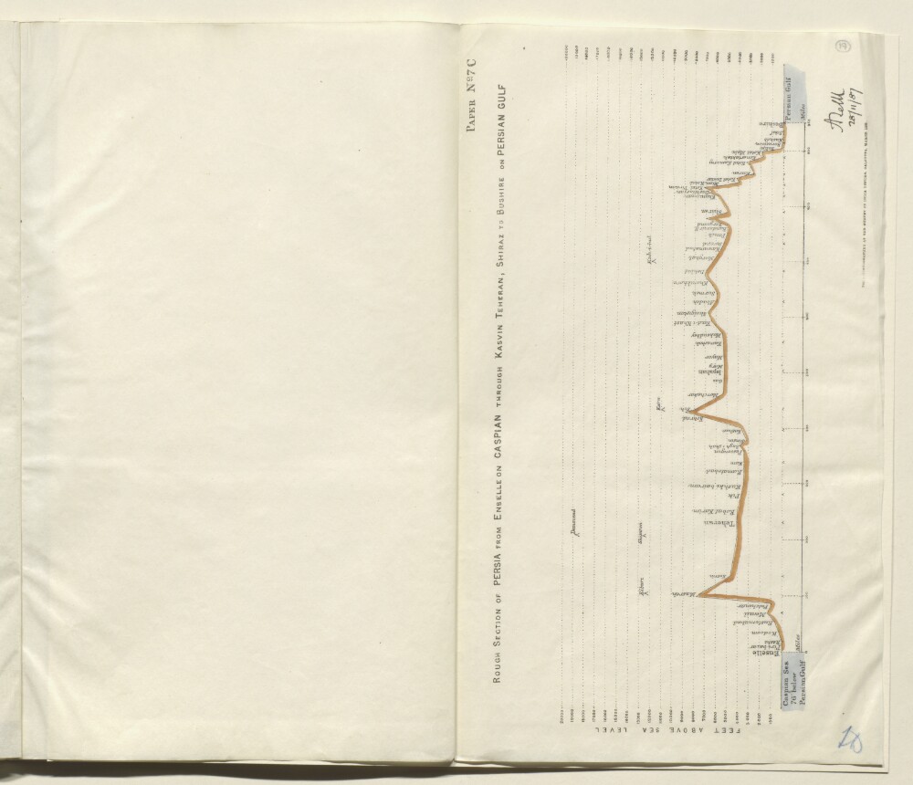
Abstract: Plan marked paper no. 7C, indicating the height above sea level (expressed in feet) of the route taken from Enselle [Bandar-e Anzalī] near Rasht, to Bushire, via Kasvin [Qazvin], Teheran [Tehran] and Shiraz, by Colonel Augustus Le Messurier of the Bombay Engineers, in 1887. The section is drawn as a solid black and red line, with the Caspian Sea on the left side of the plan, and the Persian Gulf on the right side. Towns and cities along the route are marked on the section. Significant mountains (for example, Demavend [Kūh-e Damāvand]) are also marked on the route.The plan bears a printed signature (illegible) in the bottom right corner, dated 28 November 1887. Under the plan is the statement: ‘Photozincographed at the Survey of India Office, Calcutta, March 1888.’Physical description: Dimensions:393 x 333 mm.Materials:Printed on paper.
Abstract: The file consists of a printed volume regarding the field notes on Mesopotamia. The volume was prepared on behalf of the General Staff, India and printed by the Superintendent Government Printing, India.The volume is divided into the following chapters:I. History.II. Geography.III. Population.IV. Resources.V. Notes on the Turkish Army.VI. Maritime.VII. Administration.VIII Communications; Routes in Mesopotamia.The volume also contains a number of appendices: A. Important personages; B. Table of Distances (in miles); C. Weights, Measures, Currency, Chronology; D. Some notes for officers proceeding to Mesopotamia; Glossary of Terms.Physical description: Foliation: the foliation sequence commences at the inside front cover with 1, and terminates at the inside back cover with 169; these numbers are written in pencil, are circled, and are located in the top right corner of the recto side of each folio.Pagination: the file also contains an original printed pagination sequence.
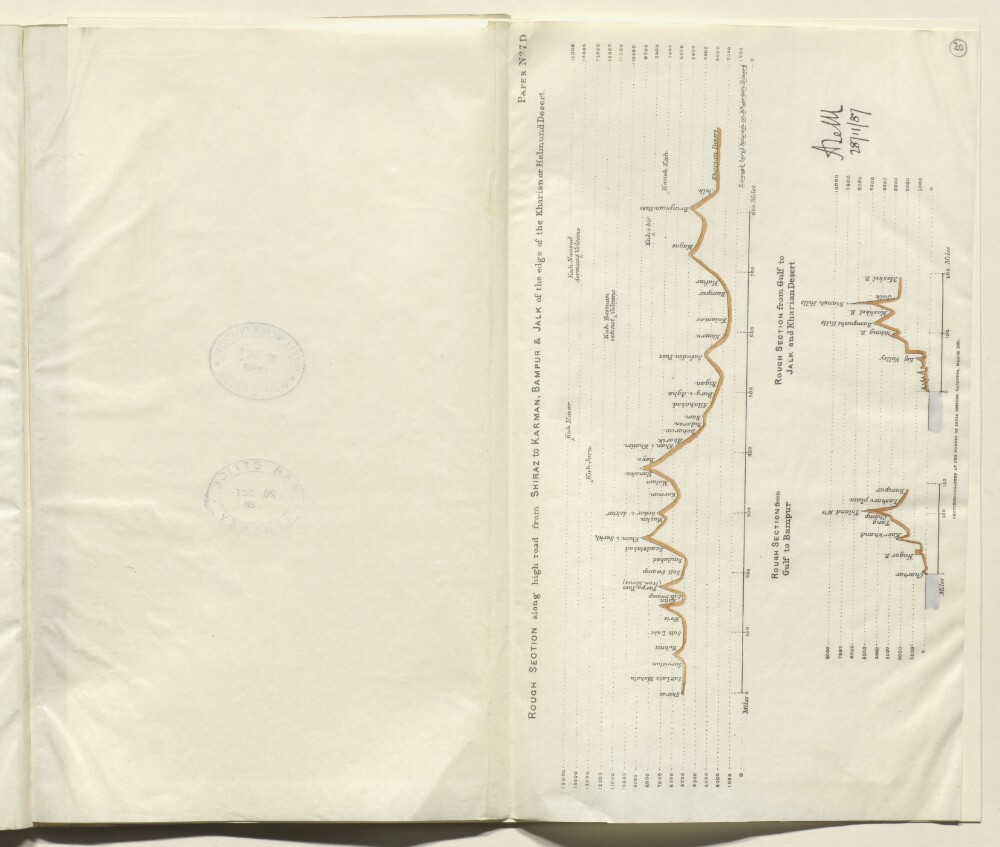
Abstract: Plan marked paper no. 7D, indicating the height above sea level (expressed in feet) of three sections of the route taken from Rasht to Bushire, by Colonel Augustus Le Messurier of the Bombay Engineers, in 1887. The three sections are as follows:rough section along the high road from Shiraz to Karman [Kerman], Bampur and Jalk [Jālq], at the edge of the Kharian Desertrough section from the Persian Gulf to Bampurrough section from the Persian Gulf to Jalk and the Kharian DesertThe sections are drawn as solid black and red lines. Towns and cities along the route are marked on the section. Significant mountains are also marked on the route. Varying vertical scales are used for the sections.The plans bear a printed signature (illegible) in the bottom right corner, dated 28 November 1887. Under the plan is the statement: ‘Photozincographed at the Survey of India Office, Calcutta, March 1888.’Physical description: Dimensions:393 x 333 mm.Materials:Printed on paper.