1 - 9 of 9
Number of results to display per page
Search Results

1. ‘PERSIAN GULF: PLANS OF THE NORTH EAST COAST OF BAHRAIN ISLAND’
- Description:
- Abstract: A map included to illustrate proposals for an alighting area at Manama to facilitate the introduction of flying boat services by Imperial Airways via Bahrain. It illustrates the seaborne approaches to Bahrain Harbour and Khor Kaliya [Khawr al Qulay‘ah]. The map shows Bahrain island and the surrounding sea. It includes soundings in fathoms with supplementary depth contours, and highlights features to aid the navigator. The map also outlines Manama and Muharraq and details buildings (prominent buildings being labelled).Manuscript additions to the map have been included. Red additions outline the proposed alighting area, the proposed location of moorings, and a proposed location for a passenger shelter. It also includes the location of the pre-existing Royal Air Force (RAF) pier. Navigation beacons have been highlighted in orange. The Imperial Airways Landing Ground has been highlighted using pencil.A conversion table for converting between British fathoms and feet into meters has been included with the map.Two inset maps have also been included showing portions of the main map in greater detail. These maps illustrate Bahrain Harbour and Khor Kaliya respectively; the scale of the inset maps is 1:21,000. In contrast, the scale of the main map is 1:50,000.London. Published at the Admiralty, 14 August 1936, under the superintendence of Rear Admiral John Augustine Edgell, CB, OBE, Hydrographer. Sold by J D Potter, Agent for the sale of Admiralty charts. The map was first engraved in 1936, and corrected in 1937.Physical description: Material: Printed on paper, with manuscript additions in ink and pencil.Dimensions: 635 x 987mm, on sheet 698 x 1007mm

2. ‘Persian Gulf single charts.–Memoir.–Lieut. Houghton’
- Description:
- Abstract: The volume contains a ‘memoir’ written by Lieutenant Michael Houghton, draughtsman on board the Honorable Company’s ship Discovery, which consists of a description of places encountered during the East India Company’s survey of the Persian Gulf during the 1820s. The memoir covers the survey’s journey in a southwesterly direction along the Arab coast of the Gulf, between Moosendem [Musandam] and Debay [Dubai], and taking in the principal settlements of Shaum [Ash Sha‘m or Sha’am], Ul Umrah [Jazīrah al Ḩamrā’], Raumps [Ar Rams], Rasel Khyma [Ra’s al-Khaymah], Ul Umrah [Al Jazīrah al Ḩamrā’], Amulgawein [Umm al-Qaywayn], Aymaun [‘Ajmān] and Sharja [Sharjah]. At the front of the volume is a note written by Lieutenant John Michael Guy, Lieutenant Commanding the Honorable Company’s ship Discovery, and Officer in Charge of the Persian Gulf trigonometric survey (f 3), and a preface written by Houghton (f 4).The main body of the account provides observations of:landscape topography, including capes, mountains, inlets, bays, flora and fauna;landscape geology, including unusual rock formations, mineral deposits, ‘trap’ (igneous rock), and soil, leading at times to conjectures by the author on the historic formation of the geological landscape and its changing sea levels, with reference to the theories of contemporary scientists including Erhard Georg Friedrich Wrede and Christian Leopold von Buch;hydrography, including depths in fathoms, water currents, backwaters, and accessibility of waterways and their danger to vessels;human settlements, the names of which are transliterated into English, with descriptions of their condition (i.e. ‘deserted’), estimates of population size, tribal affiliation, details of the settlement’s chief economic activities (primarily fishing and date cultivation, with estimates of revenue), agriculture (crops and animal husbandry), descriptions of its notable built structures (forts, mosques, houses, tombs) and burial mounds;the various rulers of the region, with reference to the towns and populations they preside over, and in the case of the most prominent rulers (for example the ruler of Sharjah, Sultan ben Suggar [Shaikh Sultan bin Saqr Āl Qāsimī]) descriptions of their character, demeanour and attitude to their English visitors;climate, with details of winds, temperature and atmospheric conditions, with summaries of journal entries recorded between the months of October and May (no year stated, ff 22-24).Throughout the text Houghton makes frequent reference to ‘the expedition’, referring to the punitive expedition undertaken by the Honorable Company’s Marine to Ra’s al-Khaymah and the surrounding area (widely referred to as the ‘pirate coast’) in 1819.The volume should be read in conjunction with ‘Coast Views taken while employed on the Survey of the Arabian Side of the Gulf of Persia by Lieutenant M. Houghton, Draughtsman H.C. Marine’ (IOR/X/10310) and various maps and charts (drawn by Houghton) relating to the Arab coast of the Persian Gulf, between Musandam and Dubai (IOR/X/3680-3690).Physical description: Pagination: the volume has an original pagination system beginning at 3 and ending at 41. Numbers are located centre and top of each page of text.
3. File 351/1904 'Persian Gulf:- Erection of British flagstaffs at Musandam’
- Description:
- Abstract: The volume comprises correspondence and other papers relating to the erection (and subsequent abandonment) of flagstaffs at the head of the Persian Gulf, on the Maklab [Maqlab] Isthmus at Musandam (Musandam spelt with numerous variations throughout the file), Telegraph Island [Jazīrat al Maqlab], and Sheep Island [Jazīrat Umm al Ghanam].The correspondence includes:a report of the Viceroy of India’s tour of the Persian Gulf in 1903, dated 21 January 1904 and signed by several individuals (including George Nathaniel Curzon and Horatio Herbert Kitchener) containing proposals for the erection of naval bases, coaling stations, and telegraph facilities in the Gulf (ff 213-215);proposals and arrangements for the erection of flagstaffs by HMS Sphinxin November 1904, made by Major William George Grey, Political Agent at Muscat, Lieutenant William Henry Irvine Shakespear, Assistant Resident and Acting British Consul at Bunder Abbas [Bandar-e ʻAbbās], Captain Thomas Webster Kemp, Senior Naval Officer in the Persian Gulf and Commander of HMS Sphinx, including reports submitted by Shakespear and Kemp describing the erection of the flagstaffs, including accounts of the discussions held with the inhabitants of the areas around which the flagstaffs were erected, and a map indicating the location of the flagstaffs (ff 112-114, 119-121);questions of whether to fly the Union Jack or Blue Ensign on the flagstaffs;Government concerns that the flagstaffs were situated in territory claimed by the Sultan of Maskat [Muscat];Admiralty objection to the flagstaffs, on the grounds that it would be the Navy’s responsibility to protect them;the decision of the Committee of Imperial Defence (CID) to maintain the flagstaff at Telegraph Island, but abandon the flagstaffs at the Maklab Isthmus and Sheep Island;further reconsideration of the proposal to fly a British flag on Telegraph Island, in the wake of investigations by John Gordon Lorimer which assert the Sultan of Muscat’s sovereignty over Musandam;deferral of the decision on the flagstaff at Telegraph Island until the outcome of the Hague Tribunal on vessels at Muscat flying the French flag; the removal, in October 1905, of the flagstaffs on the Maklab Isthmus and Sheep Island;final instruction from the Foreign Office to the Government of India, in May 1908, that the remaining flagstaff on Telegraph Island should be no longer maintained.The file also includes a report of the survey of Khor Kawi [Khawr al Quway‘] by HMS Sphinx, dated 31 December 1903, with a map showing water depths in Khor Kawi (ff 190-192), and a letter from the Commander-in-Chief of the East Indies Station, Vice Admiral George L Atkinson-Willes, to the Government of India, dated 5 September 1905, recommending that Khor Kawi be used as a new British naval base, rather than Elphinstone Inlet or Telegraph Island (ff 34-35).The volume includes a divider which gives the year that the subject file was opened, the subject heading, and a list of correspondence references contained in it arranged by year. This divider is placed at the front of the volume (f 3).Physical description: Foliation: the foliation sequence commences at the inside front cover with 1, and terminates at the inside back cover with 225; these numbers are written in pencil, are circled, and are located in the top right corner of the recto side of each folio. A previous foliation sequence, which is also circled, has been superseded and therefore crossed out.

4. 'File 2/8 II Kuwait water supply from the Shatt al-Arab'
- Description:
- Abstract: This file contains correspondence among British officials in the Persian Gulf and London, as well as the Kuwaiti Government on various means of securing a reliable supply of water for Kuwait. The papers vary from proposal for a condensing plant, and possible pipeline from Basra in Iraq, to obtaining the details of how much such ventures would cost and which firms could possibly oversee their construction. The papers also contain letters from various Kuwaiti merchant contractors and the Kuwait Oil Company relating to the construction of a pipeline from the oil company to Kuwait's principal settlement.The file also contains early maps of Kuwait's geology used to ascertain the viability of groundwater.Physical description: Foliation: the foliation sequence for this description commences at the front cover with 1, and terminates at the inside back cover with 232; these numbers are written in pencil, are circled, and are located in the top right corner of the recto side of each folio. A previous foliation sequence, which is also circled, has been superseded and therefore crossed out. Two additional irregular foliation sequences are present in parallel between; these numbers are also written in pencil, but are not circled, and are at times crossed out.

5. Sketch showing Sharjah Creek
- Description:
- Abstract: A sketch map showing Sharjah Creek (also referred to as Shajah Khor) created as a result of a survey undertaken by the Nearchus: this survey shows the whole creek. An appended note dated 5 January 1940 by John Baron Howes, Political Officer for the Trucial Coast can be found on folio 54. The purpose of the survey was to establish whether dredging the creek is a viable proposition. Proposed dredging stretches are indicated by small red coloured boxes labelled 1, 2, and 3. Sharjah has been highlighted as is the Shaikh of Sharjah's Fort. No key is given.Physical description: Materials: Manuscript; coloured pencil and coloured crayon on paperDimensions: 343 x 216mm

6. Sketch map of Sharjah Creek
- Description:
- Abstract: A sketch map showing a section of Sharjah Creek (also referred to as Shajah Khor) created as a result of a survey undertaken by the Nearchus: a sketch map of the whole creek can be found on folio 53. An appended note dated 5 January 1940 by John Baron Howes, Political Officer for the Trucial Coast can be found on folio 54. The purpose of the survey was to establish whether dredging the creek is a viable proposition. The map illustrates a proposed dredging stretch labelled 1 to 2, it also shows the approximate location of Sharjah town, Leyya Village, and the position of a petrol store and a nearby hill. The creek is coloured blue, the sand banks yellow, and the settlements in pencil.Physical description: Materials: Manuscript; coloured pencil and coloured crayon with typed additions on paperDimensions: 343 x 216mm
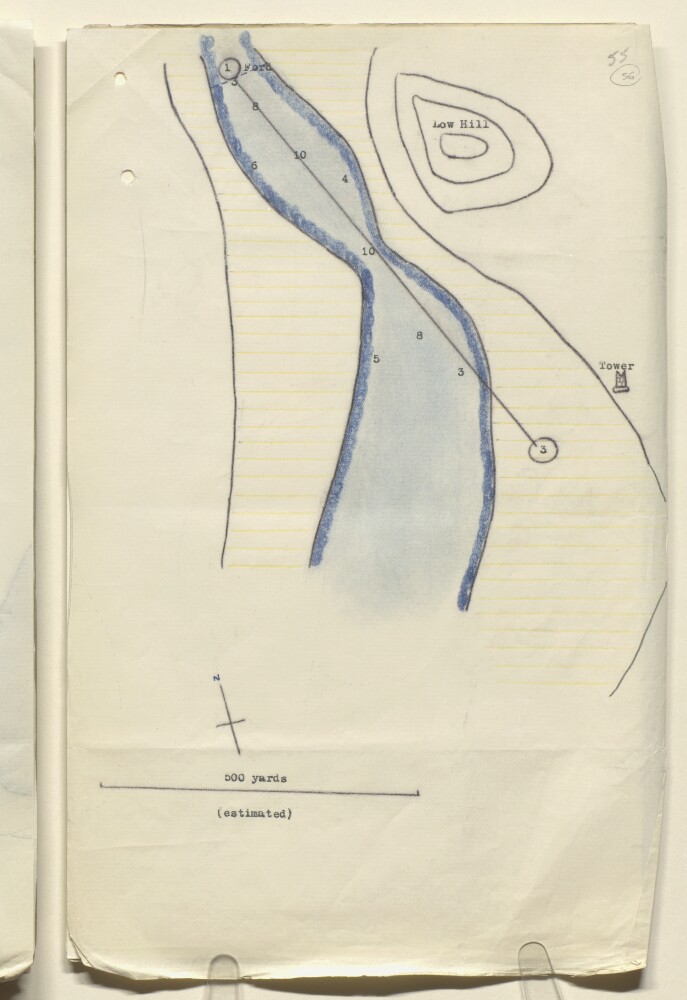
7. Sketch map of Sharjah Creek
- Description:
- Abstract: A sketch map showing a section of Sharjah Creek (also referred to as Shajah Khor) created as a result of a survey undertaken by the Nearchus: a sketch map of the whole creek can be found on folio 53. An appended note dated 5 January 1940 by John Baron Howes, Political Officer for the Trucial Coast can be found on folio 54. The purpose of the survey was to establish whether dredging the creek is a viable proposition. The map illustrates a proposed dredging stretch labelled 1 to 3, it also shows the position of a tower, and a nearby hill. The creek is coloured blue.Physical description: Materials: Manuscript; coloured pencil and coloured crayon with typed additions on paperDimensions: 343 x 216mm
8. Sketch Map of Dubai Creek
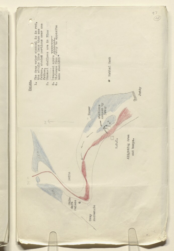
- Description:
- Abstract: A map illustrating Dubai Creek created as a result of a survey undertaken between 11-14 January 1941 by Bernard Whitteron, Chartered Civil Engineer, on behalf of the British Overseas Airways Corporation (BOAC). It is appended to a report: see folios 43-47. The purpose of the survey is to investigate the silting of the creek and to propose possible engineering solutions. The jetty used by BOAC flying boat services has been marked, as are a couple of proposed spurs. Shindara palace, the Gray Mackenzie building, Hattai Bank, and the alighting area have also been highlighted.Physical description: Materials: Manuscript; pencil and coloured crayon with typed additions on paperDimensions: 215 x 342mm

9. Coll 30/182 'Oil: Question of survey of north-eastern corner of Qatar.'
- Description:
- Abstract: The file concerns a request by Petroleum Development (Qatar) Limited to the India Office that a British Government survey vessel should survey the north-east coast of the Qatar Peninsula between Ras Umm Hasah and Ras Luffain [Ra's Lafān]. The area between those two places had been identified by the company as the only possible site for a sea loading terminal in Qatar.In reply, the Military Branch of the Admiralty stated that they had no plans to survey the area, and declined to assist the company further.The file includes a divider, which gives a list of correspondence references contained in the file by year. This is placed at the back of the correspondence.Physical description: Foliation: the foliation sequence (used for referencing) commences at the front cover with 1, and terminates at the inside back cover with 8; these numbers are written in pencil, are circled, and are located in the top right corner of the recto side of each folio.