Number of results to display per page
Search Results
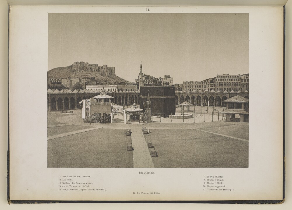
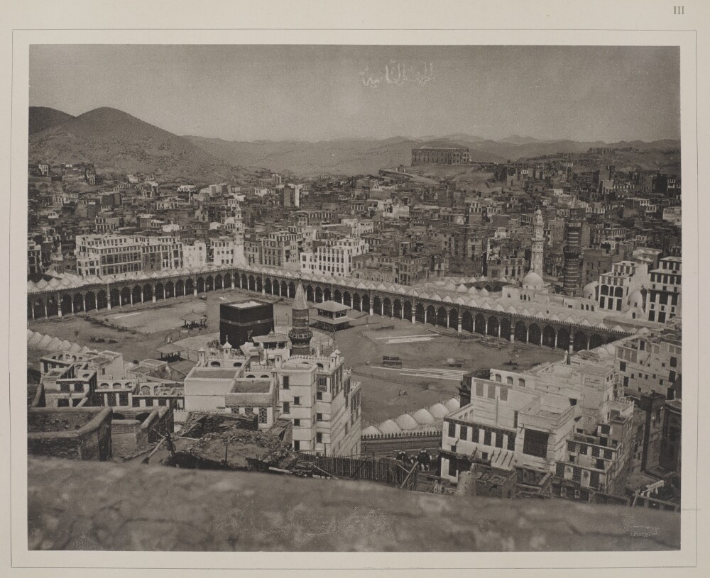
13. 'Die Moschee'.
- Description:
- Abstract: Genre/Subject Matter:This south-southwest view inside the Masjid al-Haram of the Caaba and surrounding structures is a print of a drawing after a photograph of the same view by the Meccan photographer, and doctor, al-Sayyid ʻAbd al-Ghaffār. This photograph, in the collection of the Universiteit Leiden's Oriental Institute, is reproduced as Fig. 14 in F. E. Peters, The Hajj: The Muslim Pilgrimage to Mecca and the Holy Places, Princeton, NJ: Princeton University Press, 1994.In the left background, a fortified structure can be seen. This is identified as ‘Jiyad Castle’. Some Ottoman-era buildings can be seen in the nearer background, immediately outside of the mosque, including a large pale-coloured building almost immediately below the castle. This is referred to as the Hamidiyah and is likely a building constructed during the reign of the Ottoman Sultan Abdulhamid II.Numbers printed within the image refer to locations indicated in a key (in German) below the image. These are as follows: Gate of the Banī Shaybah; The Hijr [Ismail]; Building housing the Zamzam well; Stairs to the Caaba; Maqām Ibrahīm, which is also the Maqām el-Schāfi’ī’; Minbar; Maqām al-H̱anafī; Maqām al-Mālikī; Maqām al-H̱anbalī; front-side of the Hamidiyah.Inscriptions:Printed above image, in ink:IIPrinted beneath image, in ink:‘Die Moschee.’‘1. Das Thor der Benī Schēbah. 2. Das H̱idjr. 3. Gebäudes Zemzembrunnens. 4 und 5. Treppen zur Ka’bah. 6. Maqām Ibrāhīm (zugleich Maqām ès-Schāfi’ī). 7. Mimbar (Kanzel) 8. Maqām èl-H̱anafī. 9. Maqām èl-Mālikī. 10. Maqām èl-H̱ambalī. 11. Vorderseite der H̱amīdijjah. 12. Die Festung des Djijād.’Scattered throughout image: numbers 1–12Physical description: Dimensions:199 x 260 mmFormat:1 print of a drawing after a photograph, bound into volumeCondition:The print is in good condition with only minor surface dirt throughout.Foliation:‘II’
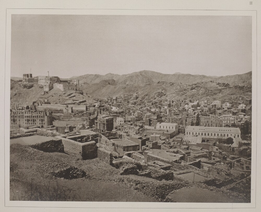
14. 'Erste Ansicht der Stadt Mekka: links im Hintergrund die Festung Djijād. Das grosse Gebäude rechts ist ied [sic for ‘die’] H̱amīdijjah, links daneben die Druckerei'. Photographer: al-Sayyid ʻAbd al-Ghaffār
- Description:
- Abstract: Genre/Subject MatterThis image shows a view over the city of Mecca from an elevated position east of the Masjid al-Haram, or Grand Mosque. Parts of the city due south of the mosque are visible in the middle ground. (Compare, for example, X463/1.)In the left of the image on the horizon, the fortified structure known as ‘Jiyad Castle’ is visible. The large building on the right is identified in the title as the ‘Hamidiyah’, a two-storey building which is described in the title of a photograph in Christiaan Snouck Hurgronje’s earlier publication of 1888, Bilder-Atlas zu Mekka(1781.b.6/4) as a government building built by Governor General Othman Pascha. This was likely constructed during the reign of the Ottoman Sultan Abdulhamid II (1876–1909) and was therefore relatively new.The two-storey pale-coloured building to the left of this is identified as the ‘printing house’ (cf. X463/6).Derelict or semi-derelict structures make up the foreground while hills rise in the background.This is the first of four photographs taken from the same vantage point, which form a panoramic view over the city of Mecca. The second, third and fourth are X463/3, X463/4 and X463/5 respectively.InscriptionsAbove image, on the right, in ink: ‘II’Lower centre and upper centre: Illegible, partially erased Arabic scriptPhysical description: Dimensions:190 x 243 mmFormat:Collotype print, pasted into volumeCondition:The print is in good condition with minor surface dirt and light abrasions, though no surface losses in the lower right of centre.Foliation:‘II’Process:Collotype
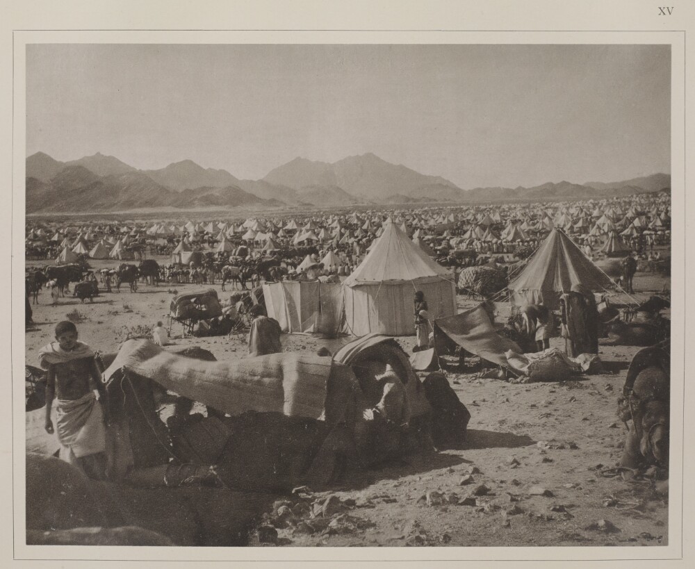
15. 'Dritte Ansicht desselben; im Hintergrund windet sich der Weg nach Mekka'. Photographer: al-Sayyid ʻAbd al-Ghaffār
- Description:
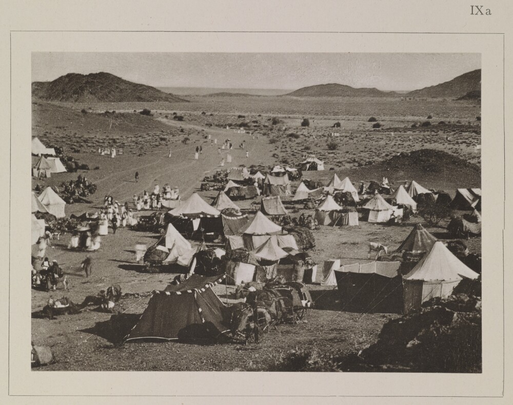
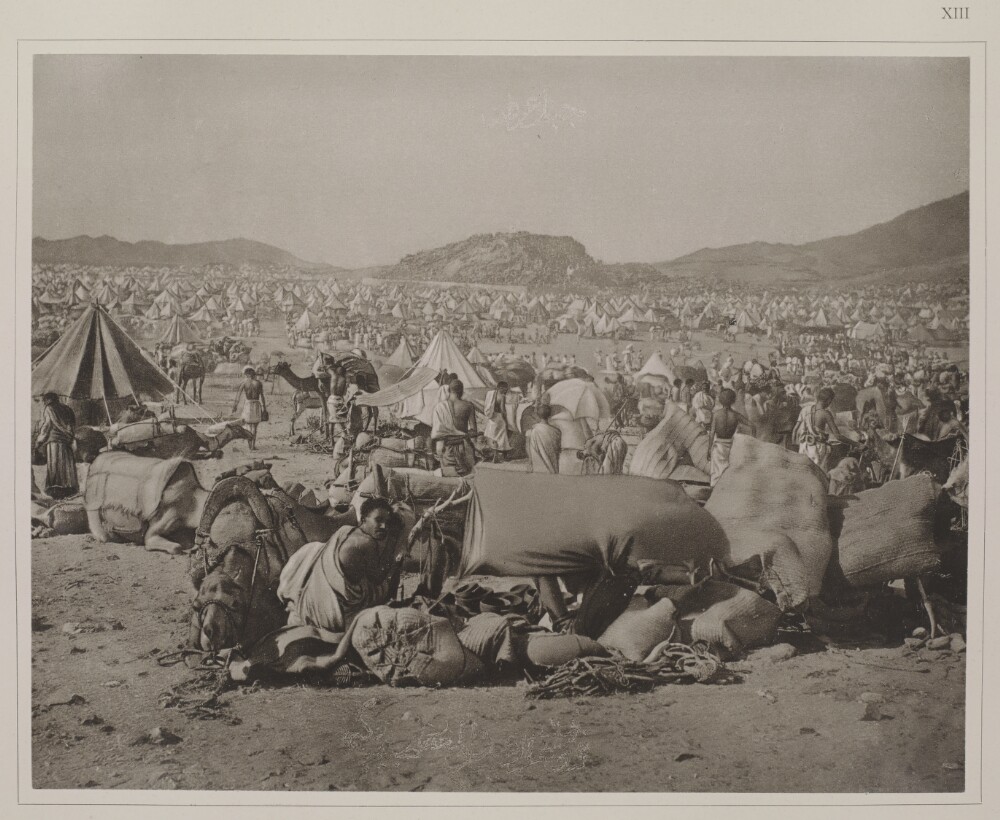
- Abstract: Genre/Subject Matter:This landscape view shows an expansive camping ground near Mecca at a place called Sarif (Saref or ‘èn-Nawwārijjeh’, according to Snouck Hurgronje), described as ‘the grave of our lady Maymūna [the last of nine wives married to the prophet Mohammed] and camp of the Meccan pilgrims who travelled there’. Snouck Hurgonje, in the second volume of his publication Mekkadescribes the place, as well as the festival of ‘Sittanā Mèjmūnah’ in detail.Much of the foreground and middle ground is littered with tents of varying shapes and sizes. Several low-lying hills are evident in the background, while a pathway snaking from left through the centre into the distance is described as ‘the way to Mecca’ in the title.Tradition relates that she requested to be buried at this location, where she married Mohammed.This photograph is described as a ‘third view’, however, it does not appear to have been taken from the same vantage point as the two previous photographs.Inscriptions:Above image, on the right, in ink: ‘IXa’Temporal Context:According to Durkje van der Wal in his publication Christiaan Snouck Hurgronje: The First Western Photographer in Mecca, 1884-1885(Amsterdam : Manfred & Hanna Heiting Fund, Rijksmuseum, 2011, pp. 43-51), the photographs in this publication that pertain to the hadj (this image included) likely date to August 1888 since this was the period of the last hadj before February 1889, the date Christiaan Snouck Hurgronje received the final consignment of images.Physical description: Dimensions:103 x 145 mmFormat:Collotype print, pasted into volumeCondition:The print is in good condition with minor surface dirt and light abrasions throughout.Foliation:‘IXa’Process:Collotype
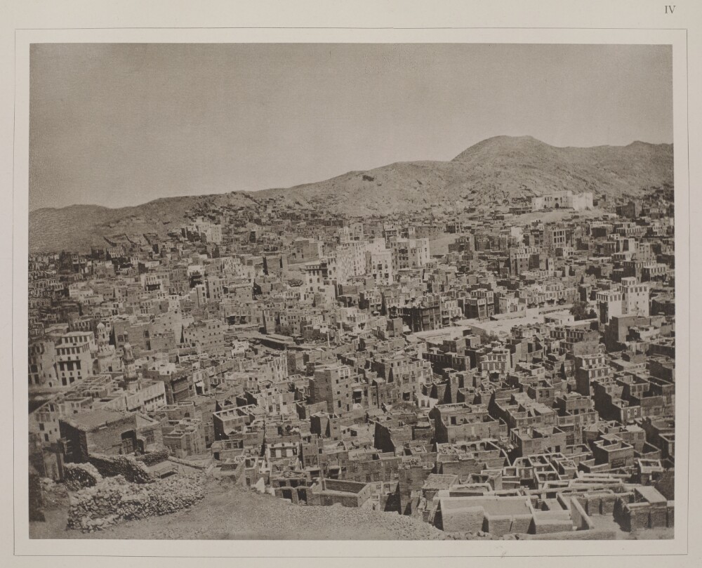
16. 'Dritte Ansicht der Stadt Mekka: links die nördliche Ecke der Moschee; ein wenig südostlich von derselben das Bāb ès-salām, durch welches die Pilger in die Moschee eintreten'. Photographer: al-Sayyid ʻAbd al-Ghaffār
- Description:
- Abstract: Genre/Subject MatterThis image shows the city of Mecca from an elevated position due east of the Masjid al-Haram, or Grand Mosque. Parts of the city due north of the Masjid al-Haram are visible in the middleground.A large two-storey, fortified building is situated immediately below the horizon on the foothills of the northern ridge, to the right of the image. The northernmost part of the Masjid al-Haram is visible just below the central point on the left edge of the image.Derelict or semi-derelict structures make up the lower left foreground while a long ridge is visible in the background.This is the third of four photographs taken from the same vantage point, which form a panoramic view over the city of Mecca. The first, second and fourth are X463/2, X463/3 and X463/5 respectively.The negative has had hand-work applied, creating a drawing-like quality along the left-hand edge.InscriptionsAbove image, on the right, in ink: ‘IV’Lower centre and upper centre: illegible, partially erased Arabic scriptPhysical description: Dimensions:188 x 245 mmFormat:Collotype print, pasted into volumeCondition:The print is in good condition with minor surface dirt and light abrasions, though no surface losses in the lower right of centre.Foliation:‘IV’Process:Collotype
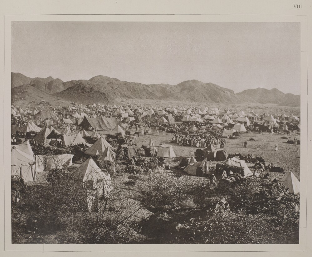
17. 'Zweite Ansicht des Lagers der Mèjmūnahpilger'. Photographer: al-Sayyid ʻAbd al-Ghaffār
- Description:
- Abstract: Genre/Subject Matter:This landscape view shows an expansive camping ground near Mecca at a place called Sarif (Saref or ‘èn-Nawwārijjeh’, according to Snouck Hurgronje), described as ‘the grave of our lady Maymūna [the last of nine wives married to the prophet Mohammed] and camp of the Meccan pilgrims who travelled there’. Snouck Hurgonje, in the second volume of his publication Mekkadescribes the place, as well as the festival of ‘Sittanā Mèjmūnah’ in detail.Much of the foreground, middle ground and background is littered with tents of varying shapes and sizes. In the foreground bushes can be seen and in the middle ground and background pilgrims are grouped together. A ridge of hills rises to the left and extends into the far distance on the right along the horizon.Tradition relates that she requested to be buried at this location, where she married Mohammed. A group of pilgrims form a circle to the right of the centre of the image. At centre, the camera has captured the movement of pilgrims walking.The negative has had hand-work applied, creating a drawing-like quality in places, particularly in the background.This is the second of two photographs taken from the same vantage point, which form a panoramic view over the camp. The first is X463/7.Inscriptions:Above image, on the right, in ink: ‘VIII’Temporal Context:According to Durkje van der Wal in his publication Christiaan Snouck Hurgronje: The First Western Photographer in Mecca, 1884-1885(Amsterdam : Manfred & Hanna Heiting Fund, Rijksmuseum, 2011, pp. 43-51), the photographs in this publication that pertain to the hadj (this image included) likely date to August 1888 since this was the period of the last hadj before February 1889, the date Christiaan Snouck Hurgronje received the final consignment of images.Physical description: Dimensions:188 x 244 mmFormat:Collotype print, pasted into volumeCondition:The print is in good condition with minor surface dirt and light abrasions throughout.Foliation:‘VIII’Process:Collotype
18. 'Zweite Ansicht der Stadt Mekka über die nordwestliche (rechts) und die südwestliche Seite (links) der Moschee hinaus'. Photographer: al-Sayyid ʻAbd al-Ghaffār
- Description:
- Abstract: Genre/Subject MatterThis image shows the Caaba and Sanctuary at Mecca from an elevated position due east of the Masjid al-Haram, or Grand Mosque. Parts of the northwest and southwest of the city of Mecca are visible in the middleground. (Compare, for example, ‘Picture of the City of Mecca the Great’ Photo 174/3 from almost the same vantage point.)Due to the relatively slow shutter speed used by the photographer, the movement of the pilgrims performing tawaf– the ritual of circumambulation of the Caaba seven times in a counter-clockwise direction during the hadj or umrah, starting from the black stone – is captured here as indistinct blurring of the figures closest to the Caaba on the left. There is a range of activity occurring through the mostly empty expanse around the Caaba. White, straight lines to the right and left of the Caaba as well as some activity near the cloisters on the right may indicate some form of construction work underway.A large two-storey building is situated immediately below the horizon on the foothills of the northern ridge.In the immediate foreground a wall or parapet is out of focus. Derelict or semi-derelict structures make up the lower left foreground while hills rise in the background.This is the second of four photographs taken from the same vantage point, which form a panoramic view over the city of Mecca. The first, third and fourth are X463/2, X463/4 and X463/5 respectively.The negative has had hand-work applied, creating a drawing-like quality.InscriptionsAbove image, on the right, in ink: ‘III’Lower centre and upper centre: Illegible, partially erased Arabic scriptPhysical description: Dimensions:186 x 240 mmFormat:Collotype print, pasted into volumeCondition:The print is in good condition with minor surface dirt and light abrasions, though no surface losses in the lower right of centre.Foliation:‘III’Process:Collotype
19. 'Westliche Seite des Berges'. Photographer: al-Sayyid ʻAbd al-Ghaffār
- Description:
- Abstract: Genre/Subject Matter:This landscape view shows ‘the west side of the Mount [‘Arafah]’ as well as the Plain of Arafat or ‘Arafah. Located 21 km southeast of the Masjid al-Haram, the plain, which extends 6km from east to west and 12 km from north to south, and the 70 metre high granite hill at the centre of it are stations of the hadj. Mount Arafat is located northeast of the plain and is also known as Jabal al-Rahmah or Mount of Mercy.On the ninth day of Dhul-Hijjah, known as the Day of Arafat, just before noon, pilgrims gather on the plain to perform wuqufor ‘standing before God’, as can be seen in this image: this is a pillar of the hadj and must be undertaken in order the pilgrimage to be valid. In this image the background and middle ground are populated by pilgrims and their tents while in the left middle ground beasts of burden, including horses, camels and donkeys can be seen.A boy standing by the tent in the foreground at left and facing the camera has a shaved head and wears the two piece garb, consisting of two white seamless sheets, associated with being in the state of ihram. At right a camel is couched; this is the same camel visible in X463/14.The negative has had hand-work applied, creating a drawing-like quality throughout where the original plate may have been over-exposed and where the photographer wished to pick up some small details, such as the face of the boy at left.Arabic script written directly into the image has been erased subtly, but is visible upon close inspection in the lower right of the image as well as in the central sky area of the image.This is the third (left hand) of three photographs taken from the same vantage point, which form a panoramic view over the plain. The first and second are X463/14 and X463/15 respectively.Inscriptions:Above image, on the right, in ink: ‘XV’Temporal Context:According to Durkje van der Wal in his publication Christiaan Snouck Hurgronje: The First Western Photographer in Mecca, 1884-1885(Amsterdam: Manfred & Hanna Heiting Fund, Rijksmuseum, 2011, pp. 43-51), the photographs in this publication that pertain to the hadj (this image included) likely date to August 1888 since this was the period of the last hadj before February 1889, the date Christiaan Snouck Hurgronje received the final consignment of images.Physical description: Dimensions:190 x 243 mmFormat:Collotype print, pasted into volumeCondition:The print is in good condition with minor surface dirt and light abrasions throughout.Foliation:‘XV’Process:Collotype
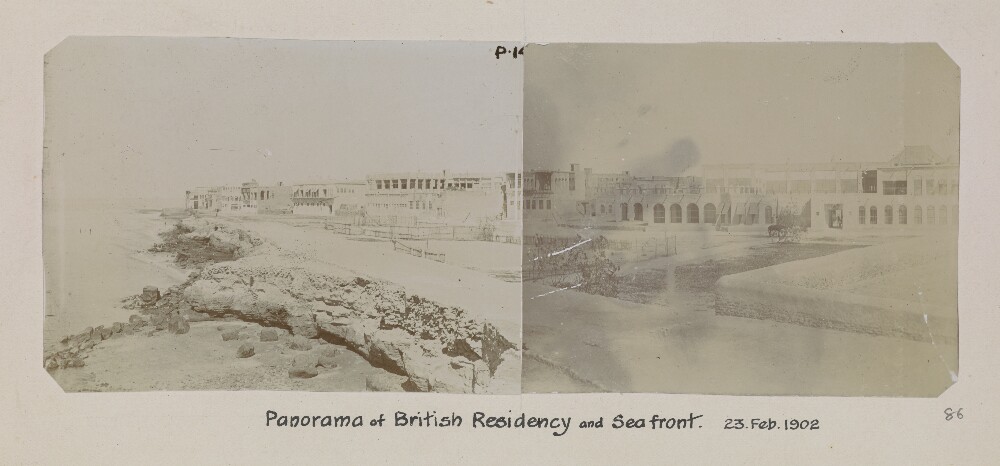
20. 'Panorama of British Residency and Sea front. 23. Feb. 1902'. Photographer: Arthur Alexander Crookshank
- Description:
- Abstract: Genre/Subject MatterThis panoramic view of the British Residency and sea-front at Bushire (Būshehr) consists of two small photographic prints pasted side by side, showing a series of buildings of uniform two-storeyed height receding into the distance along the sea-front from right to left.In the right-hand image rose bushes appear to be growing in the expanse between the sea and the buildings. Behind them a lone donkey is tethered.Although the clarity of the image is seriously compromised by fading, there appears to be a telegraph mast or flag pole along the right edge of the left-hand image, extending across to the right-hand image.Some distant figures and a boat are visible along the shoreline.InscriptionsLower right, in pencil, alongside image: ‘86’Below image: ‘Panorama of British Residency and Sea front. 23. Feb. 1902’Physical description: Dimensions:71 x 185 mm (71 x 96 mm; 71 x 89 mm) [landscape]Format:Materials:Condition:The right-hand image is heavily stained (likely originating in the printing process) with two scratch surface-losses near the left edge. and one longer scratch extending from the lower right corner.The left-hand image exhibits minor abrasion all along the left edge of the image with two small surface losses at centre in the sky area.While the left-hand image is considerably faded, the right hand image is darker due to staining.Foliation:'p. 14'; '86'Process:
21. 'Der Berg ‘Arafah während der jährlichen Pilgerversammlung (von Süden aus gesehen)'. Photographer: al-Sayyid ʻAbd al-Ghaffār
- Description:
- Abstract: Genre/Subject Matter:This landscape view shows the 'Mount‘Arafah, during the annual gathering of pilgrims [hadj] (as seen from the south)’ as well as the Plain of Arafat or ‘Arafah. Located 21km southeast of the Masjid al-Haram, the plain, which extends 6km from east to west and 12km from north to south, and the 70 metre high granite hill at the centre of it – visible here on the horizon at centre – are stations of the hadj. Mount Arafat is located northeast of the plain and is also known as Jabal al-Rahmah or Mount of Mercy.On the ninth day of Dhul-Hijjah, known as the Day of Arafat, just before noon, pilgrims gather on the plain to perform wuqufor ‘standing before God’, as can be seen in this image: this is a pillar of the hadj and must be undertaken in order the pilgrimage to be valid. In this image the background and middle ground are populated by pilgrims’ tents.Most of the pilgrims visible here – male and female – are wearing the two piece garb, consisting of two white seamless sheets, associated with being in the state of ihram. The men have clearly shaved their heads as a part of the ritual cleansing ceremony undertaken at the beginning of the hadj in order to enter into the state of ihram.In the foreground, two camels are couched at left, an awning or tent billows in the wind and a crouching man turns to face the camera, though most other figures face away from it.The negative has had hand-work applied, creating a drawing-like quality throughout , where the original plate may have been over-exposed.Arabic script written directly into the image has been erased subtly, but is visible upon close inspection in the lower centre of the image as well as in the central sky area of the image.This is the first (central) of three photographs taken from the same vantage point, which form a panoramic view over the plain. The second and third are X463/15 and X463/16 respectively.Inscriptions:Above image, on the right, in ink: ‘XIII’Temporal Context:According to Durkje van der Wal in his publication Christiaan Snouck Hurgronje: The First Western Photographer in Mecca, 1884-1885(Amsterdam : Manfred & Hanna Heiting Fund, Rijksmuseum, 2011, pp. 43-51), the photographs in this publication that pertain to the hadj (this image included) likely date to August 1888 since this was the period of the last hadj before February 1889, the date Christiaan Snouck Hurgronje received the final consignment of images.Physical description: Dimensions:193 x 245 mmFormat:Collotype print, pasted into volumeCondition:The print is in good condition with minor surface dirt and light abrasions throughout.Foliation:‘XIII’Process:Collotype
22. 'South Persia'. Photographer: Lt. A. A. Crookshank (Curzon Collection)
- Description:
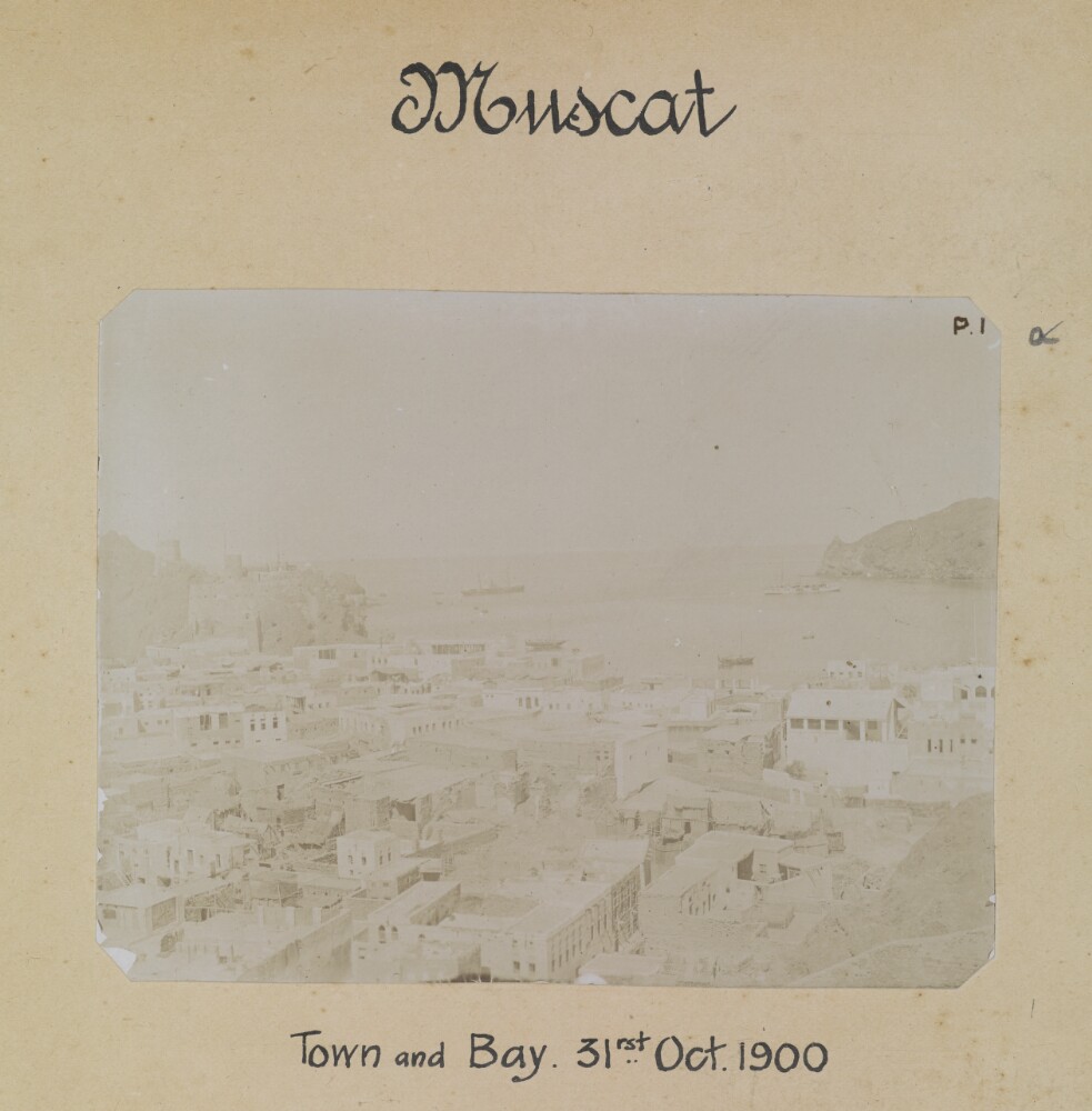
- Abstract: Genre/Subject Matter:The album contains landscape and architectural views of South Persia and the Persian Gulf coastline. The photos are presented initially by location (Muscat, Jask, Bandar Abbás, Niríz, Yezd, Isfahan to Shiráz Road, Pasargadae, Naksh-i-Rustam, Naksh-i-Rajab, Persepolis, Shiráz, Feragha, Chinár Rahdár, Shápur, Shiráz-Bushire Road, Bushire), thereafter by subject (Persian Flora, Persian Dwellings, Persian Roads, Persian Scenery).Elements:1 [Muscat] Town and Bay. 31st Oct 19002 [Muscat] The Town looking North. 31 Oct 19003 [Muscat] British Consulate. 31 Oct 19004 [Muscat] Old Portuguese Fort (1550). 31 Oct 19005 [Muscat] Sultan's Palace. 31 Oct 19006 [Muscat] Sidap. Village. 31 Oct 19007 [Jask] Telegraph Buildings. 1 Nov 19008 [Jask] Fort and Beach. 1 Nov 19009 [Bandar Abbás] Sea front looking West. 11 Nov 190010 [Bandar Abbás] The Town looking West. 11 Nov 190011 [Bandar Abbás] Beach and island of Hormuz. 11 Nov 190012 [Bandar Abbás] British Consulate. 11 Nov 190013 [Niríz] Panorama of Town looking South. 30 April 190114 [Niríz] Town looking North. 30 April 190115 [Yezd] The City looking East from the Masjid-i-Juma. 10 July 190116 [Yezd] The City looking South from the Masjid-i-Juma. 10 July 190117 [Yezd] The City from the Masjid-i-Juma looking West. 10 July 190118 [Yezd] The City looking West from the Mínár-i-Maidán. 13 July 190119 [Yezd] The City looking North from the Minár-i-Maidán. 13 July 190120 [Yezd] The City looking South from the Minár-i-Maidán. 13 July 190121 [Yezd] The Masjid-i-Juma. 9 July 190122 [Yezd] The Masjid-i-Juma. 9 July 190123 [Yezd] Main Gate of Fort. 13 July 190124 [Yezd] The Maidán-i-Sháh. 13 July 190125 [Yezd] Gate of Old Fort. 13 July 190126 [Yezd] Mosque of Mir Chakhmakh. 13 July 190127 Caravanserai at Khána-i-Kirgam. 27 Oct 190128 Bridge at Khána-i-Kirgam. 27 Oct 190129 [Pasargadae] The Tomb of Cyrus. 30 Oct 190130 [Abarkuh] Memorial to Darius at Arbela 331 B.C. 10 Oct 190131 [Pasargadae] Ruins of Cyrus’ City. 29 Oct 190132 [Naksh-i-Rustam] Bas-relief Ormuzd and Ardeshir 5 Nov 190133 [Naksh-i-Rustam] Rock tombs of the Kings. 5 Nov 190134 [Naksh-i-Rustam] Building near Tombs of the Kings. 5 Nov 190135 [Naksh-i-Rustam] Fire Altars. 5 Nov 190136 [Naksh-i-Rustam] Bas relief. Equestrian Combat. 5 Nov 190137 [Naksh-i-Rustam] Bas relief. Equestrian Combat. 5 Nov 190138 [Naksh-i-Rustam] Shapur and Valerian at Edessa A.D. 260. 5 Nov 190139 [Naksh-i-Rustam] Varahran and his Queen A.D. 500 5 Nov 190140 [Naksh-i-Rustam] Varahran II and his Court. 5 Nov 190141 [Naksh-i-Rajab] Shapur I and his Bodyguard. 5 Nov 190142 [Naksh-i-Rustam] Tombs of the Kings. The East Tomb. 5 Nov 190143 [Persepolis] Palace of Darius. 6 Nov 190144 [Persepolis] Palace of Darius. Interior. 6 Nov 190145 [Persepolis] Panorama of the Platform looking South and West. 6 Nov 190146 [Persepolis] Grand Entrance. Porch of Xerxes. 6 Nov 190147 [Persepolis] Pillars in Hall of Xerxes. 6 Nov 190148 [Persepolis] King fighting Dragon. Hall of 100 Columns. 6 Nov 190149 [Persepolis] The North Tomb Artaxerxes II 6 Nov 1901.50 [Persepolis] King on Throne and Procession Doorway. Hall of 100 Columns. 6 Nov 190151 [Persepolis] The King held up on Throne. Doorway in Hall of 100 Columns 6 Nov 190152 [Persepolis] King with Attendant. Palace of Xerxes 6 Nov 190153 [Persepolis] The King. Palace of Artaxerxes III. 6 Nov 190154 [Persepolis] Hall of Hundred Columns etc. 6 Nov 190155 [Persepolis] The great Staircase and Platform. 6 Nov 190156 [Shiráz] Tomb of Sultán Mir Shah. 15 Dec 190157 [Shiráz] Cemetery of Great Men. 15 Dec 190158 [Shiráz] Bas relief. Farhád and Shirín in the Bágh-i-Nao 15 Dec 190159 [Feragha] Ancient figure of animal in stone. 14 Oct 190160 [Shiráz] Approach to City from Tang-i-Korán. 18 Dec 190161 [Shiráz] The City looking West. 15 Dec 190162 [Shiráz] The City looking East. 15 Dec 190163 [Shiráz] The City looking North. 15 Dec 190164 [Shiráz] The Bágh-i-Takht. 16 Dec 1902 [sic for 1901]65 [Shiráz] Cemetery of Haft Tan. 18 Dec 190166 [Shiráz] Cemetery of Chel Tan. 18 Dec 190167 [Chinár Rahdár] The Caravanserai and Bridge. 23 Dec 190168 [Shápur] Ruins of King Shápur’s City. 16 Jan 190269 The River near Shapur. 16 Jan 190270 [Shápur] Bas-relief. Omuzd and Narses. 15 Jan 190271 [Shápur] Bas-relief. The Captives before Shapur. 15 Jan 190272 [Shápur] The Investiture of Cyriadis by Shapur. 15 Jan 190273 [Shápur] Valerian, Cyriadis and King Shapur. 15 Jan 190274 [Shápur] Valerian suppliant before King Shapur. 16 Jan 190275 [Shápur] Statue of King Shapur in cave. 16 Jan 190276 [Shápur] Bas-relief. Triumph of Chosroes Naushirwán 16 Jan 190277 Caravanserai at Mian Kotal. 9 Jan 190278 Lake near Kazerun from Kotal-i-Dukhtar. 8 Jan 190279 Bridge near Daliki from upstream. 21 Jan 190280 Bridge near Daliki looking upstream. 21 Jan 190281 Telegraph Quarters. Kunár-i-Takhta. 20 Jan 190282 The landing place at Shif. 29 Jan 190283 [Bushire] The town looking South from Gray Paul's office. 23 Feb 190284 [Bushire] The town looking East from British Residency. 23 Feb 190285 [Bushire] Telegraph Buildings at Reshire. 24 Feb 190286 [Bushire] Panorama of British Residency and Sea front. 23 Feb 190287 The Assafoetida plant. East of Niríz. 21 April 190188 Walnut trees. North of Niríz. 6 May 190189 Almond grafted onto wild tree. N of Furg 26 March 190190 Oak trees in Kuh Marra. S of Shiráz. 27 Dec 190191 The “Archan” Tree in pink blossom. N of Furg. 25 March 190192 Oak trees near Kazerun. 14 Jan 190293 Mastich and wild pistachio trees. S of Shiráz 31 Dec 190194 Oak Trees in Kuh Marra. South of Shiráz. 27 Dec 190195 Cypress Tree in mountains. East of Niríz. 27 April 190196 Tents of matting of Kermán tribes in Rudbár. 30 Nov 190097 Tents of black goats hair. Kermán tribes in Rudbár. 2 Dec 190098 Cave dwellers. E of Furg. 7 Feb 190199 A Village East of Yezd. 2 July 1901100 The Chieftain’s Cave. Cavedwellers. E of Furg. 2 Feb 1901101 The Chieftain’s Tent. Nomad tribes near Bandar Abbás. 21 Feb 1901102 A country house and garden. North of Niríz. 2 May 1901103 Bágh-i-Nawwáb. A Garden in the suburbs of Yezd. 4 Sept 1901104 Tank for rainwater. N of Bandar Abbás 21 Feb 1901105 The Prince’s Palace and Govt. House at Yezd. 13 July 1901106 Bágh-i-Eram. A Garden in the suburbs of Shiráz 13 Dec 1901107 The Tang-i-Zágh Defile N of Bandar Abbás. 11 March 1901108 A pass West of Fasa. 28 Nov 1901.109 Shiráz-Bushire. The “Kotal-i-Dukhtar” 8 Jan 1902110 Shiráz-Bushire. The “Kotal-i-Kumárij” 20 Jan 1902111 Shiráz-Bushire. The “Kotal-i-Mahallu” 21 Jan 1902112 Shiráz-Bushire. The “Pul-i-Gina” Viaduct near Kazerun. 8 Jan 1902113 The Bushire-Lingah Road near Riz. 28 March 1902114 The Well with three pulleys for irrigating crops near Lingah. 14 April 1902.115 The West end of Salt Lake near Niríz looking North. 20 Nov 1901116 The West End of Salt Lake near Niríz looking N.W. from hills above. 21 Nov 1901117 The Salt Desert of Sirján in Kermán. 15 April 1902118 The Lake near Kázerún looking North 4 Jan 1902Inscriptions:Inner cover, in pencil: ‘Copy negs done Stannard 25-9-79’Title page, in ink: 'Presented to / H.E. Lord Curzon of Kedleston etc etc / Viceroy of India / by / Lieut. Arthur A. Crookshank / Royal Engineers / June 1903'Spine, gold emboss: ‘Photos’ ‘South Persia’Throughout the album captions and location or subject categories are hand-lettered in black ink.Physical description: Dimensions:Album: 250 x 305 x 40 mm [portrait]Format:Maroon and red three quarter-leather album containing one hundred and eighteen prints hand-cut and pasted onto card pages.Materials:Card, black ink, gelatin silver prints.Condition:While the binding is still sturdy for the most part – aside from extensive scuffing and losses at all edges, particularly upper spine – the individual card pages are extensively foxed and discoloured throughout. The lower right corner of page 13–14 has broken off entirely.Many of the individual images are faded and some show signs of surface losses.Foliation:The images have been numbered 1–118 alongside each image in pencil and paginated 1–47 in pencil in the upper right corner. Some additional image sequencing in pencil in the first twenty nine pages of the album (e.g. a–d on each page) has been crossed out.Process:Gelatin silver printsBinding:The album is bound in maroon three-quarter-leather format, which is heavily scuffed along the spine, particularly at the upper spine.This binding likely dates to its presentation to Lord Curzon and indicates the title of the album with gilt stamp ‘ Photos’ ‘South Persia’. The binding also features linen joints and hand-stitching.
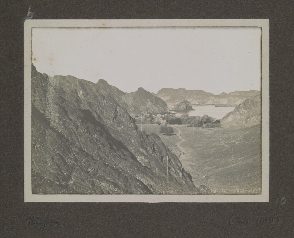
23. 'Riyam'
- Description:
- Abstract: Genre/Subject Matter:This image shows Riyam and parts of the bay in the right background.Rocky outcrops descend from left to centre of the image where several poles, perhaps telegraph poles, can be seen.Inscriptions:Lower left, below image, in pen: ‘Riyam.’Upper left, above image, in pencil, crossed-out: ‘b’Lower right, alongside image, in pencil: ‘10’Lower right, below image, in pen: ‘(Jan. 1918)’Physical description: Dimensions:70 x 95 mmCondition:The image is in good condition.Foliation:'b'; '10'Process:Silver gelatin print
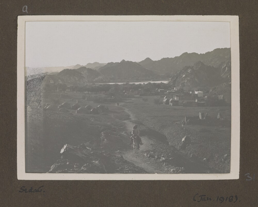
24. 'Sedab'. Photographer: Rev. Edwin Aubrey Storrs-Fox
- Description:
- Abstract: Genre/Subject Matter:This scene, taken from an elevated position looking towards a settlement and, behind it, a body of water, shows the village of Sidāb, approximately 3 km south of the Bay of Muscat (See also: Photo 430/8/6 for a similar view of the same village.)A path leads from the lower centre of the image to the dwellings in the distance. A man rides a donkey towards the camera while other figures are gathered or walk along the path in the distance. On the left of the path some domed tents are visible, but the dwellings and structures in the distance and to the right of the path are more permanent built structures, including at least one white-washed building. Palms and other vegetation are interspersed around the village and coastline.Along the horizon in the far distance beyond the water rocky hills rise from left to right.Damage, printing error or a light leak has caused a band, most discernible in the centre of the left of the image to appear under-exposed in the print. Graphite appears to have been applied to the print over this area.Inscriptions:Lower left, below image, in pen: ‘Sedab’Upper left, above image, in pencil: ‘a’Lower right, alongside image, in pencil: ‘31’Lower right, below image, in pen: ‘(Jan. 1918)’Physical description: Dimensions:71 x 96 mmCondition:The image is in good condition.Foliation:'a'; '31'Process:Silver gelatin print
- « Previous
- Next »
- 1
- 2 Current Page, Page 2
- 3