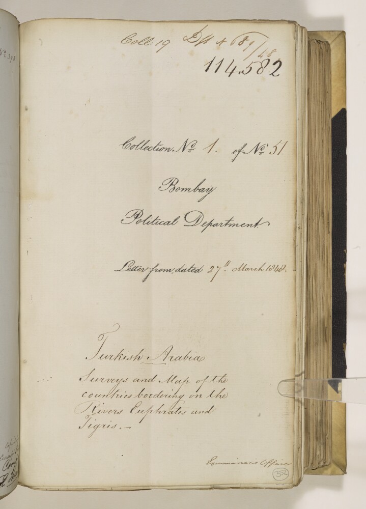
Abstract: This item consists of copies of correspondence, consultations, memoranda, and minutes, cited in, or enclosed with, political letters from the Government of Bombay. The correspondents are: the Government of Bombay; Major Henry Rawlinson, Political Agent in Turkish Arabia [Ottoman Iraq]; Lieutenant-Colonel Commandant Chief Engineer George Jervis; Captain Sir Robert Oliver, Superintendent of the Indian Navy; Captain Henry Blosse Lynch; and the Government of India.The item concerns the surveys of the Euphrates, Tigris, and Kuran [Karun] rivers, and the process of Captain Felix Jones creating a new chart from the results of Lynch’s survey expeditions. The item includes details of the employment of draughtsmen, the creation of copies, and lists of surveys, but it does not contain copies of the maps or surveys themselves.The item contains a contents page and the title page of the item contains the following references: ‘Draft no 689/48’, ‘Coll[ection]: 19’, ‘Collection No 1 of No 51’.Physical description: Foliation: the foliation sequence (used for referencing) commences at the first folio with f 352, and terminates at f 382 as it is part of a larger physical volume; these numbers are written in pencil, are circled, and are located in the bottom right corner of the recto side of each folio.Pagination: the item also contains an original pagination sequence.
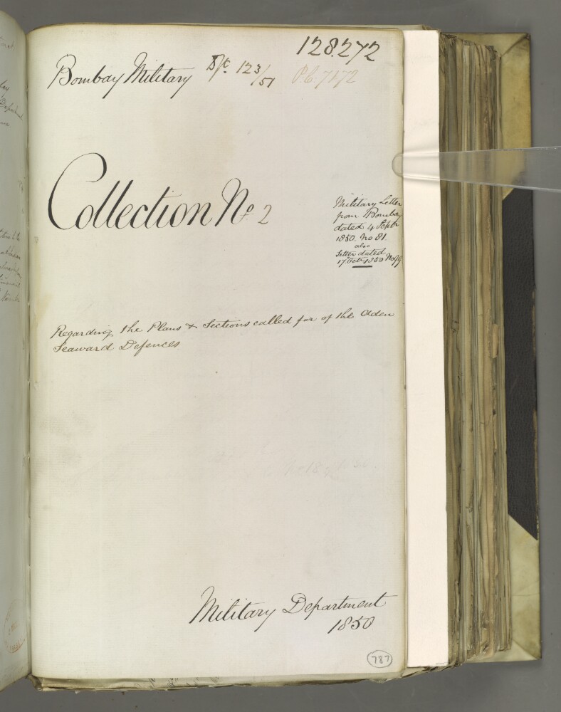
Abstract: The item consists of copies and extracts of correspondence cited in, or enclosed with, extracts of two Military Letters from the Government of Bombay to the East India Company Court of Directors, dated 4 September and 16 October 1850 respectively.The item relates to the delay in supplying the Court of Directors with plans and [cross] sections of the seaward defences at Aden. The Military Board, Bombay, put forward their reasons for this delay and outline the information they require from the Home authorities before they can suggest the points on the defences which would be best suited for armament. There is also discussion about the need to supply plans and sections for works being carried out on the isthmus.Correspondents: the Court of Directors; the Military Board; and the Government of Bombay.Folio 789a verso contains a stamp which reads: 'RECEIVED. 26 NOV. [1]850. SOUTHHAMPTON'.The title page of the item contains the following references: 'Bombay Military', 'P.C. [Previous Communication] 7172, Draft No. 123 of 1851', 'Collection No 2', and 'Military Department 1850'.Physical description: Foliation: the foliation sequence for this description (used for referencing) commences at f 787, and terminates at f 796, as it is part of a larger physical volume; these numbers are written in pencil, are circled, and are located in the bottom right corner of the recto side of each folio. The sequence contains one foliation anomaly: f 789a.Pagination: the item also contains an original pagination sequence.
Abstract: This item consists of copies of correspondence, minutes, and consultations, cited in, or enclosed with a political letter from the Government of Bombay [Mumbai].The item concerns the creation of a ‘map of Arabia including portions of Africa and Persia’ by Lieutenant-Colonel Thomas Dickinson, Chief Engineer, Bombay, at the request of the Government of India, and the subsequent production and distribution of copies of this map.The primary correspondents are: the Government of Bombay Council; Lieutenant-Colonel Dickinson, Chief Engineer, Bombay; Lieutenant-Colonel George Ritso Jervis, Chief Engineer, Bombay (occupying this post subsequent to Lieutenant-Colonel Dickinson); and John Gordon, Postmaster General, Bombay.The item contains a table of contents (ff 89-90), and the title page (f 88) contains the following references: 'P C [Previous Communication] 5061, Coll. 36', 'D/t 29/46', 'Collection No. 1 of No. 88' and 'Examiner’s Office'.Physical description: Foliation: the foliation sequence (used for referencing) commences at the first folio with f 88 and terminates at f 113, as it is part of a larger physical volume; these numbers are written in pencil, are circled, and are located in the bottom right corner of the recto side of each folio.Pagination: the volume also contains an original pagination sequence.
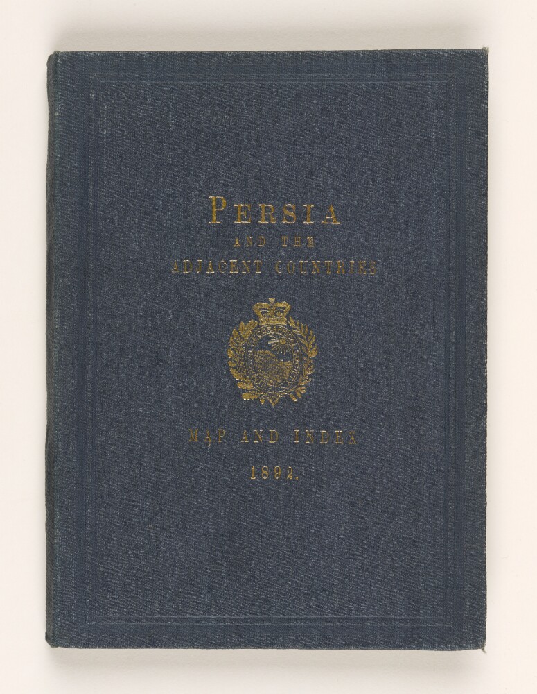
Abstract: This book consists of a map of Persia, with a memorandum and index, prepared by William John Turner for the Royal Geographical Society under the supervision of the Hon George Nathaniel Curzon, M P.The memorandum is written by George Curzon, a Member of Parliament, and explains the origins of the mapping exercise and the issues involved. An appendix lists the maps directly used in the compilation of the new map and a second appendix lists those maps not used but which were useful for reference. There then follows an index of place names and accompanying grid references to the map. The folded map is placed at the back of the publication.Physical description: Foliation: the foliation sequence (used for referencing) commences at the inside front cover with 1, and terminates at the inside back cover with 26; these numbers are written in pencil, are circled, and are located in the top right corner of the recto side of each folio. Pagination: the file also contains an original printed pagination sequence.
Abstract: The file consists of a note concerning the Aden demarcation by William Lee-Warner, India Office, Secretary to the Political and Secret Department.It discusses the following: the difficulties which have arisen in carrying out the demarcation on the Amiri frontier, the history of past agreements concerning Captain Hunter's map of 1880, the survey of Captain R A Wahab of 1891-92 with comments, the Demarcation Commission, and proposals for the future.Physical description: Foliation: the foliation sequence for this description commences at f 14, and terminates at f 15, as it is part of a larger physical volume; these numbers are written in pencil, and are located in the top right corner of the recto side of each folio. An additional foliation sequence is present in parallel between ff 19-20; these numbers are also written in pencil, but are circled.Pagination: the file also contains an original printed pagination sequence.
Abstract: The file contains correspondence related to the purchase of books and maps by the Political Agency at Bahrain, subscriptions to newspapers and periodicals, and supply of news cuttings. The documents in the file are orders for books and stationery, cheques, receipts of payment, and newspaper cuttings.The principal correspondents are:
The Times; The Times Book Club; F P Baker & Co Limited; Durrant's Press Cuttings; Cartier Limited; National Geographic Society; various printers and booksellers in the United Kingdom; the Adviser to the Government of Bahrain; the Map Sales Service at the Survey of India, in Calcutta; the Office of the Accountant General, Central Revenues, New Delhi; and the Political Agent at Bahrain.There is a letter in French within the file, from
Le Messager de Teheran;and a newspaper article in Arabic, from the Lebanese newspaper
Al Nida, with English translationPhysical description: Foliation: the main foliation sequence (used for referencing) commences at the front cover with 1, and terminates at the inside back cover with 263; these numbers are written in pencil, are circled, and are located in the top right corner of the recto side of each folio.
Abstract: The file contains the following title at the top of the notes (folio 13): 'BOOKS AND PUBLICATIONS: MAPS.'The file contains correspondence from the Political Resident in the Persian Gulf and other British officials, concerning the despatch to the Political Agency, Muscat of miscellaneous charts and maps.Correspondence dated 1945-47 relates to maps of Persia [Iran] and Arabia prepared as a result of surveys undertaken by the United States Army.Physical description: Foliation: the main foliation sequence (used for referencing) commences at the front cover with 1, and terminates at the inside back cover with 14; these numbers are written in pencil, are circled, and are located in the top right corner of the recto side of each folio. An additional foliation sequence is present in parallel between ff 2-10; these numbers are also written in pencil, but are not circled.
Abstract: The file contains covering letters and acknowledgements concerning maps.The maps concerned are: (1) blueprints of certain panoramic sketches drawn by Major Claude Edward Urquhart Bremner, Political Agent, Muscat, in the course of reconnaissances in the southern waters of Muscat and Oman (sent by Bremner to other British officials in the Persian Gulf); and (2) maps of the Rub' al Khali by Harry St John Philby and Bertram Sydney Thomas (received by Bremner from the Political Resident in the Persian Gulf).Physical description: Foliation: the main foliation sequence (used for referencing) commences at the front cover with 1, and terminates at the inside back cover with 11; these numbers are written in pencil, are circled, and are located in the top right corner of the recto side of each folio. An additional foliation sequence is present in parallel between ff 3-10; these numbers are also written in pencil, but are not circled.
Abstract: This file contains correspondence regarding a request made by the Iraq Petroleum Company to the Commonwealth Relations Office for three maps of the Arabian coast of the Persian Gulf.The Iraq Petroleum Company asks that the maps be sheets of the 1:500,000 series of maps issued by the General Staff in 1936. The maps cover Kuwait, Muscat and the south Arabian coast as far as Aden.The file features the following principal correspondents: Commonwealth Relations Office; Under-Secretary of State for Commonwealth Relations; Directorate of Military Survey, War Office; and Iraq Petroleum Company Limited.The file includes a divider which gives the subject number, the year the subject file was opened, the subject heading, and a list of correspondence references by year. This is placed at the back of the correspondence.Physical description: Foliation: the foliation sequence (used for referencing) commences at the front cover with 1, and terminates at the inside back cover with 8, these numbers are written in pencil, are circled, and are located in the top right corner of the recto side of each folio.
Abstract: This file consists of letters between H L Rabino, the India Office, and the Foreign Office, regarding the return of books and maps borrowed by Rabino from the India Survey Department. The letters refer to the procedure of recollection of borrowed books and maps. The India Office and Foreign Office discuss the origins of the maps and why they were held by Rabino. The maps relate to Iraq and Persia.Physical description: Foliation: the foliation sequence (used for referencing) commences at the front cover with 1, and terminates at the inside back cover with 9; these numbers are written in pencil, are circled, and are located in the top right corner of the recto side of each folio.
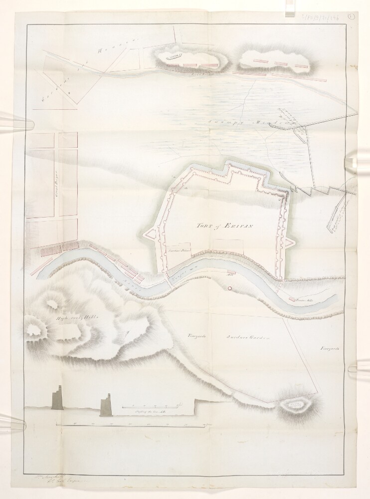
Abstract: Map detailing the Russian siege of the fortress of Erivan [Yerevan] between 5 October 1827 and 13 October 1827 during the war between Persia [Iran] and Russia [Russo-Persian War, 1826-1828], drawn up by Lieutenant-Colonel William Monteith. The map is based upon information procured by Monteith from Russian officers (see IOR/L/PS/9/71/145). The map illustrates the fortress of Erivan and the surrounding environs, indicating the sites of the bazaar, gardens, houses and vineyards of the city of Erivan, and the locations of the Russian artillery batteries and trench systems utilised during the siege. The map also shows the landscape surrounding Erivan, including hydrography and hachuring to represent the gorge of the River Zengue [River Hrazdan] and the surrounding hills. Included is a diagram of the profile of the wall of the fortress of Erivan.This document was originally enclosed, numbered 1, in dispatch No. 28 of the East India Company Envoy to Persia, Lieutenant-Colonel John Macdonald Kinneir, to the Secret Committee of the East India Company of 17 December 1827 (IOR/L/PS/9/71/145).Physical description: Manuscript: coloured ink on paperDimensions: 595 x 425mm, on sheet 630 x 458mm
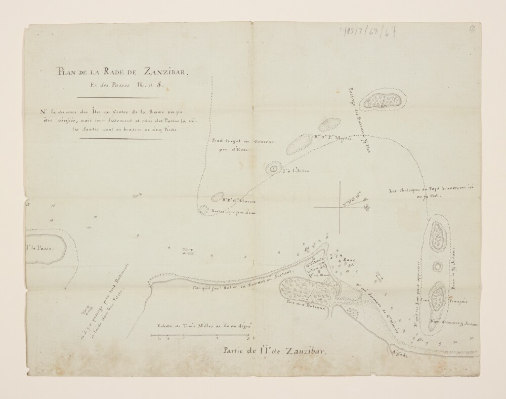
Abstract: Manuscript map used to illustrate routes of navigation around the harbour of Zanzibar [Zanzibar City] and the surrounding islands. The map indicates the coastline and coastal waters to a distance of two miles offshore, and portrays coastal and inland hydrography, vegetation, hachuring on coastal slopes, details of the fort and adjacent buildings of Zanzibar, and sandbanks, and includes topographical and navigational notes, depths by soundings, and coastal flows.The map was enclosed in HM Envoy Extraordinary and Minister Plenipotentiary to Persia [Iran], Sir Harford Jones’s Dispatch No. 25 of 14 September 1810, which was received on 6 February 1811.Physical description: Manuscript: ink on paperDimensions: 400 x 275mm, on sheet 400 x 311mm