1 - 3 of 3
Number of results to display per page
Search Results
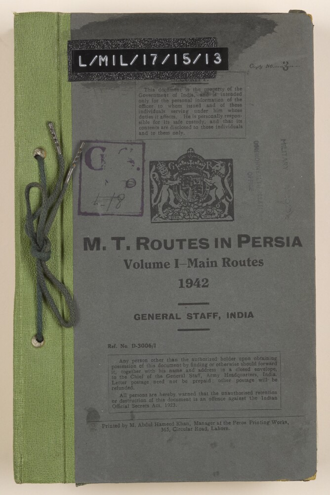
1. ‘M.T. Routes in Persia. Volume 1 – Main Routes. 1942’
- Description:
- Abstract: The volume details motor transport (‘M.T.’) routes in Persia [Iran]. The volume, which is numbered I, covers the main routes in Persia, and was produced by the General Staff, India. It was printed by M Abdul Hameed Khan, Manager of the Feroz Printing Works, Lahore, in 1942. An introduction (folio 3) states that the volume has been updated on the basis of reports received in the wake of the Anglo-Soviet invasion of Persia in August 1941.The volume comprises details of sixty-five routes, listed on the contents page, between various towns and cities in Persia. Details given for each route include:an overview (distance, number of stages, references to maps);a general report (classification of route, surface and grading, character of adjacent country, climatic effects, exceptional features, repair and supply facilities, water, fuel, fodder and grazing supplies);a detailed report (villages and other landmarks encountered, road classifications, distances).A handwritten annotation on folio 5 (author unknown) states that ‘distances are somewhat overestimated throughout this report.’ The volume includes a map in a pocket attached to the inside back cover (folio 246).Physical description: Foliation: the foliation sequence (used for referencing) commences at the front cover with 1, and terminates at the inside back cover with 247; these numbers are written in pencil, are circled, and are located in the top right corner of the recto side of each folio.Pagination: the file also contains an original printed pagination sequence.
2. Coll 6/49 'Railways and Communications: Proposed Jedda-Mecca Railway. Motor Transport Arrangements.'
- Description:
- Abstract: This file concerns the progress of schemes relating to the improvement of transport and communications in Saudi Arabia.The file largely consists of copies of correspondence received by the Foreign Office from His Majesty's Minister at Jedda (Sir Andrew Ryan, succeeded by Sir Reader William Bullard) and His Majesty's Chargé d'Affaires to Jedda (Cecil Gervase Hope Gill, and in later correspondence, Alan Charles Trott), which includes discussion of the following:Details of a failed concession for a Mecca-Jedda railway, granted by the Government of Saudi Arabia in 1933 to an Indian doctor and businessman named Saiyid Abdul Khadir Jeelani, who is reportedly unable to obtain financial support for the scheme.Difficulties regarding motor transport arrangements in Saudi Arabia during the pilgrimage season, following the creation of a motor transport monopoly in Saudi Arabia in 1936.Details of an agreement, dated 5 October 1939, between the Saudi Arabian and Egyptian Governments, primarily relating to construction and repair work on the road between Jedda and Arafat, and on certain parts of the Medina-Mecca road (the agreement also concerns the provision of water and electricity in Saudi Arabia).The file's other principal correspondents are the Foreign Secretary to the Government of India, the Chief Secretary of the Government of Madras, and various correspondents from the Foreign Office.In addition to correspondence, the file includes a copy of the scheme for the construction of a Jedda-Mecca railway and a copy of the aforementioned agreement between the Government of Saudi Arabia and the Government of Egypt.The file includes a divider which gives a list of correspondence references contained in the file by year. This is placed at the back of the correspondence (folio 2).Physical description: Foliation: the foliation sequence commences at the inside front cover with 1, and terminates at the last folio with 110; these numbers are written in pencil, are circled, and are located in the top right corner of the recto side of each folio. An additional foliation sequence is present in parallel between ff 2-110; these numbers are also written in pencil, but are not circled.
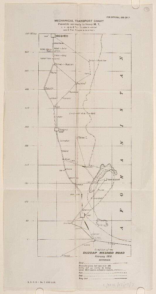
3. ‘Mechanical Transport Chart. Passable normally to M.T. (i.e. up to 3 Ton Trucks in winter and 5 Ton Trucks in summer’
- Description:
- Abstract: The map, which bears an additional title: ‘Condition of the Duzdap-Meshed Road February 1930’, indicates the road between Duzdap [Zahedan] and Meshed [Mashad] and its suitability for motor transport (‘M.T.’) The key indicates the condition of the roads on the route: good; normally good, requiring repairs; fair; bad; and very bad condition. Key towns and villages on the road are also marked. Marked in the bottom left corner of the map is the statement: ‘D[rawing].O[ffice].S[imla].I. No. E 6101 8-30.’Physical description: Dimensions: 302 x 127 mm, on sheet 390 x 205 mm.Materials: Printed on paper.