Abstract: This file begins with draft instructions, under the heading 'Anglo-Russian Relations', apparently written by John Morley, Secretary of State for India, for Sir Arthur Nicolson, British Ambassador at St Petersburg, in advance of negotiations over an Anglo-Russian agreement.The instructions are divided into two sections, 'Persia' and 'Afghanistan', and they concern Britain's and Russia's respective interests in Persia and Afghanistan. The instructions outline important points on which Nicolson is expected to base any future agreement with Russia (of which a fundamental requirement is Russia's recognition both of the independence and integrity of Persia, and of the territorial integrity of Afghanistan). The remaining instructions relate to issues of trade in Persia and Afghanistan.The draft instructions are followed by an extract from a private letter from Lord Minto [Gilbert John Elliot Murray Kynynmound], Viceroy and Governor-General of India, to John Morley, dated 12 June 1906.In the letter, Lord Minto responds to Morley's draft instructions for Sir Arthur Nicolson. Minto gives his opinions on the wording and possible implications of each paragraph of the draft instructions. Most of Minto's letter details his opposition to the idea that Great Britain and Russia should agree not to extend their railways in the direction of the frontiers of Afghanistan for the next ten years, for which Minto offers a number of political and military considerations.Minto's letter is followed by a letter from Lord Kitchener [Horatio Herbert Kitchener] to Lord Minto, dated 23 May 1906, in which Kitchener responds to Minto's letter of 19 May 1906, which requested Kitchener's opinion on the question of the Frontier railways. In his letter, Kitchener argues that the possibility of extending the British railway system is not only of great strategic importance for the defence of British India, but is also important for maintaining friendly relations with the Amir [Emir] of Afghanistan [Habibullah Khan].Kitchener's letter is followed by two loose folios which repeat word for word the aforementioned draft instructions on Afghanistan and Persia (folios 8 and 9 respectively). Both sets of instructions have the heading 'Secret'.Physical description: Foliation: the foliation sequence commences at the first folio, and terminates at the last folio; these numbers are written in pencil, are circled, and are located in the top right corner of the recto side of each folio.Pagination: the file also contains an original printed pagination sequence.
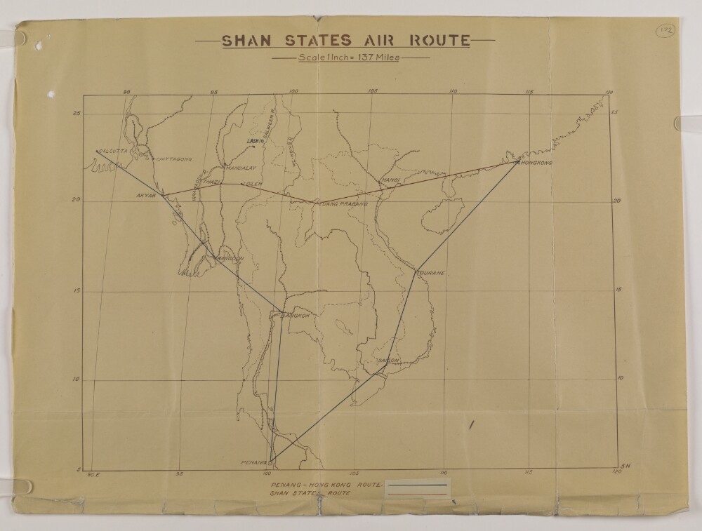
Abstract: A map accompanying a report by Frederick Tymms, Director of Civil Aviation in India, on his reconnaissance flight of 25-26 April 1937: see folios 165-171. The purpose of the flight was to explore the possibility of establishing a direct air route between Burma and Hong Kong via French Indo-China and the Shan States. The existing Penang-Hong Kong route is shown in blue and the proposed Penang-Hong Kong route in red.National boundaries and railway lines are demarcated on the map.Physical description: Materials: Printed on paperDimensions: 270 x 380mm, on sheet 360 x 485mm
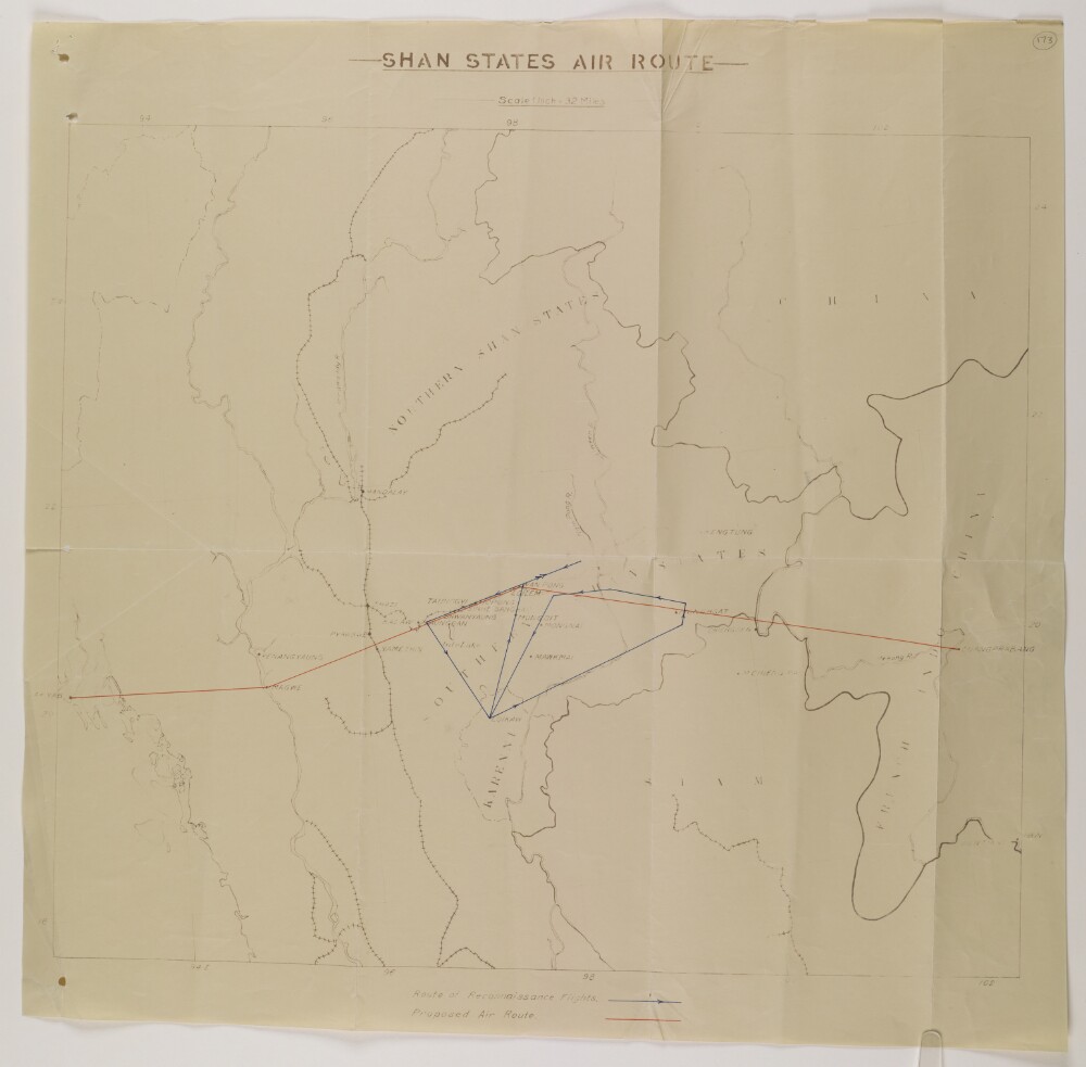
Abstract: A map accompanying a report by Frederick Tymms, Director of Civil Aviation in India, on his reconnaissance flight of 25-26 April 1937: see folios 165-171. The purpose of the flight was to explore the possibility of establishing a direct air route between Burma and Hong Kong via French Indo-China and the Shan States. The route of the reconnaissance flight is shown in blue and the proposed air route in red.National boundaries and railway lines are demarcated on the map.Physical description: Materials: Printed on paperDimensions: 440 x 508mm, on sheet 535 x 546mm
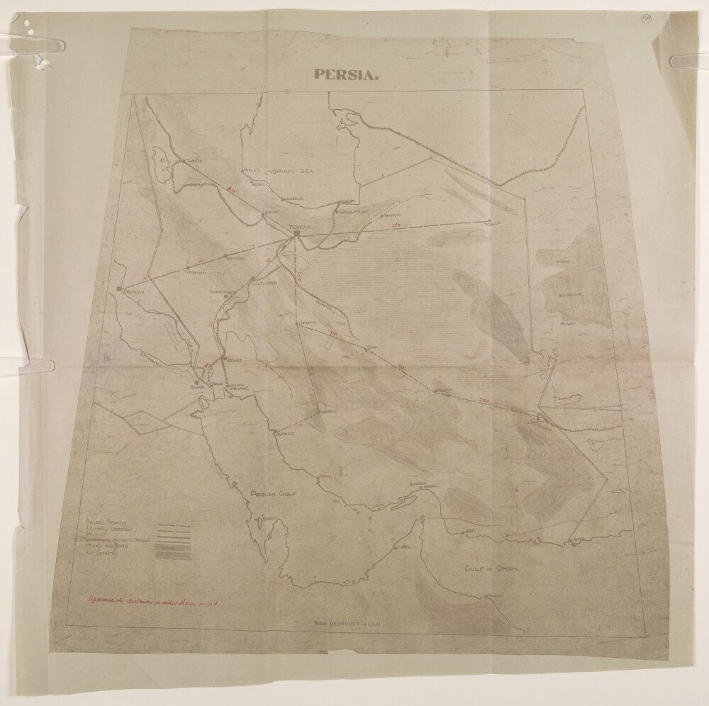
Abstract: The map accompanies a report titled ‘Air Transport in Persia – 1944 and afterwards’ by Walter Leslie Runciman, Air Attaché at Tehran: see folios 119-129. It shows Persia [Iran] in the centre bounded by Iraq to the East, Afghanistan and Baluchistan to the West, the Caspian Sea in the North, and the Persian Gulf and the Gulf of Oman in the South. It illustrates existing air routes between Tehran, and the following places: Meshed, Baghdad, and Tabriz. It also indicates proposed future routes connecting Tehran-Isphahan-Kerman-Zahidan and Tehran-Isphanan-Shiraz-Bushire. Annotations in red ink indicate the approximate distance of these routes in miles.Shading on the map is used to indicate areas of salt deserts and mountainous regions over 5000 feet. Railway lines and national borders are also marked on the map.Physical description: Dimensions: approximately 555 x 510mm, on sheet 603 x 605mmMaterials: Printed on paper, with manuscript additions in red ink
Abstract: The memorandum is concerned with Persian Baluchistan, specifically focusing on Mekran [Makran] and Sarhad, which are regarded as being of particular geopolitical interest to Britain's Indian Empire. It includes a brief description of these regions, outlines local British activities during the First World War to counter threats to their interests, and presents the current situation in Mekran and Sarhad. It also outlines proposals put forward by the Government of India in 1917 for reorganising the administration of Persian Baluchistan, with a view to protecting Britain's Indian Frontier and telegraph lines through Persia. This includes an explanation of objections put forward by the Foreign Office to these proposals.The rest of the memorandum is dedicated to the Quetta-Nushki railway extension to Duzdap [Zāhedān]; it is considering a proposal for the destruction of this extension. To this end, it includes a short history of its construction, examines the economic and political advantages of the line, and considers the possibility of a further extension of the line into Seistan [Sīstān].Physical description: Foliation: the foliation sequence commences at the first folio with 1 and terminates at the last folio with 17; these numbers are written in pencil, are circled, and are located in the top right corner of the recto side of each folio.
Abstract: This file consists of a note, written by Sir Dennis Fitzpatrick, member of the Council of India, on the subject of the northernmost portion of land in the province of Baluchistan [Balochistān], south of the Durand line, which is described as being situated between British India and Kelat [Kalat] on the east side, and Persia on the west side.The note begins by referring directly to the following letter of correspondence: 'Letter from India, No. 189, Secret,' dated 19 October 1899. The note is principally concerned with the costs and benefits of a proposed railway line, which would run from Nushki (recently taken over by the British from the Khan of Kelat) to Koh-i-Malik-Siah [Malek Sīāh Kūh], in Seistan [Sīstān].The file questions the argument that such a railway line would counteract Russian influence in Seistan. Also discussed is the extent to which the Government of India should be expected to finance such a scheme. Fitzpatrick makes the argument that it is wider Imperial interests, rather than those of the Government of India, which are most at stake, and that therefore a distribution of the cost should be made by fixed shares, rather than by relying solely on Indian revenues. He concludes by referring to a note that he wrote some months earlier, in which he advised that the control of all British affairs west of Baluchistan and Afghanistan should be vested exclusively in the Foreign Office.Physical description: Foliation: the foliation sequence commences at the first folio, and terminates at the last folio; these numbers are written in pencil, are circled, and are located in the top right corner of the recto side of each folio.Pagination: the volume also contains an original printed pagination sequence.
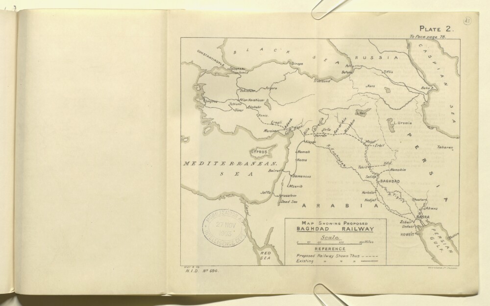
Abstract: The map shows a region encompassing parts of Russia, Persia, Arabia and the Ottoman Empire, indicating the routes of proposed and existing railway lines. The map also shows hydrology, topography and major cities and towns.The map is Plate 2 in 'Persian Gulf and Gulf of Oman' (Naval Intelligence Department No. 694), 1903, and bears the printing statement, 'Weller & Graham, Ltd. Litho, London.'.Physical description: Materials: Printed on paperDimensions: 196 x 240mm, on sheet 244 x 405mm
Abstract: Map of the Sinkiang [Xinjiang] province of China. The map is split across two sheets, the first (labelled ‘No. 1’) being the western half of the area covered, and the second (labelled ‘No. 2’) the eastern half. Both sheets have an inset map, showing the complete area of the larger map. The scale of these insets maps is 1:18,000,000. The inset map on sheet no. 1 indicates, as shaded areas, the authorities consulted for the larger map. A key to the shaded areas accompanies this inset map. The inset map on sheet no. 2 indicates the area on the whole map covered by sheet no. 2. The main map and its key indicate: railways (both open and under construction); Sinkiang and international boundaries; main routes and other routes (both in red); telegraph and telephone lines. Physical features indicated on the map are: terrain (in brown); river and water systems (in blue); settlements; deserts; and summits.Physical description: Dimensions: each map 830 x 550 mm, on sheets 925 x 680 mm.Materials: Printed in colour on paper.
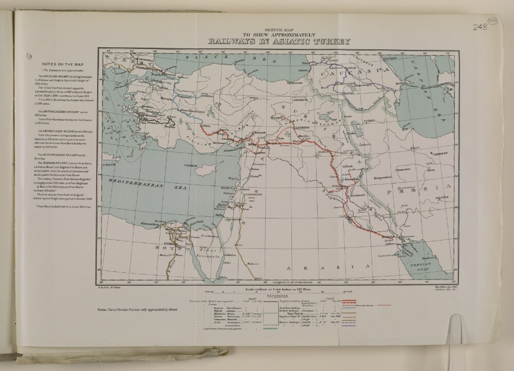
Abstract: Map, illustrating railway lines in Asiatic Turkey, to accompany
Bagdad Railway No. 1 (1911). Presented to both Houses of Parliament by Command of His Majesty, May 1911(London, His Majesty's Stationery Office). The publication appears on folios 215-252.The map was produced by the Topographical Section of the General Staff, War Office.Physical description: Material: printed on paper.Dimensions: 230 x 340mm, on sheet 320 x 450mm.
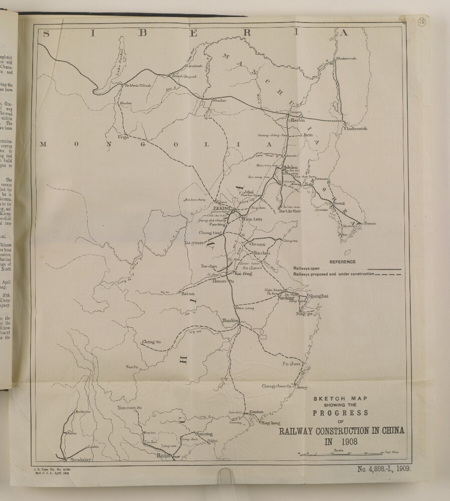
Abstract: The sketch map shows the progress of railway construction in China in 1908. It is marked with open railways and those proposed and under construction, and includes southern Siberia, and Mongolia. It is used to accompany a summary of principal events in 1908 by Wilfrid Malleson, Assistant Quartermaster-General, Intelligence Branch, Division of the Chief of Staff, Simla.The printing statement is as follows: 'Intelligence Branch Topographical Dy. 8,080. Exd. C. J. A. April 1909', 'No. 4,808.-I., 1909'Physical description: Materials: Printed on paperDimensions: 383 x 327mm, on sheet 415 x 380mm
Abstract: The key to the map indicates: roads actually in use with wheeled vehicles; roads fit for passage of wheeled artillery; camel tracks; railway lines; telegraph lines and telegraph offices; post offices; boundaries, both demarcated and undemarcated. Also indicated are rivers and waterways; settlements; marshes; and desert regions. The map was printed by the Simla Drawing Office and includes a printing statement which reads ‘D.O.S.I. No. E 6107 10-30.’Physical description: Dimensions: 520 x 370 mm, on sheet 595 x 415 mm.Materials: Printed on paper.
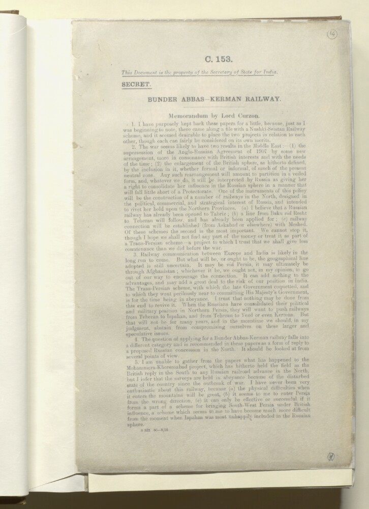
Abstract: This memorandum, written by Lord Curzon [George Nathaniel Curzon, Marquess Curzon of Kedleston], discusses a proposed Bunder Abbas–Kerman railway line. Curzon considers the possible diplomatic, commercial and strategic motives for constructing the railway line.Curzon argues that if the line has been suggested merely as a diplomatic rejoinder – that is to say, as a response to a Russian concession from Baku to Teheran [Tehran] – then the proposal is of little merit.He suggests that if the line is being proposed for its commercial value then this should be demonstrated by the figures of trade. Moreover, Curzon argues that the line's commercial effect on any future extension of the Nushki railway beyond Dalbandin should also be considered, since both lines would then be competing for the trade of East Persia and Khorasan.Curzon suggests that one strategic advantage of constructing a line from Bunder Abbas to Kerman would be the prospect of diverting a future Teheran–Yezd–Kerman Russian railway line away from the direction of India.Physical description: Foliation: the foliation sequence for this description commences at f 14, and terminates at f 14, as it is part of a larger physical volume; these numbers are written in pencil, are circled, and are located in the top right corner of the recto side of each folio. A previous foliation sequence, which is also circled, has been superseded and therefore crossed out.