1 - 4 of 4
Number of results to display per page
Search Results
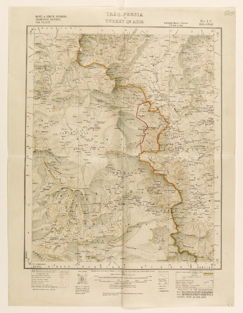
1. ‘Irāq, Persia & Turkey in Asia’
- Description:
- Abstract: Map numbered 1.C (Diza-Gawar [Diza Hawār]), and subtitled ‘Mosul & Kirkuk Divisions. Azarbāījān [Azerbaijan] Province. Van Vilayet.’ An index to the geographical location of the provinces is provided below the map. A caption under the map states that it was published under the direction of Colonel Charles Henry Dudley Ryder, Surveyor General of India, 1923. A stamp in the bottom right corner of the map states that it was published by the Geographical Section General Staff, War Office.The map indicates: relief, shown by contours and shading, with elevations given in feet; rivers, lakes, marshes; province and country boundaries; settlements, with place names in English; railways, roads and other transport routes. An additional boundary line, drawn in red ink, has been added to the map.The map is mentioned in a copy of a letter sent by HM’s Envoy Extraordinary and Minister Plenipotentiary at Tehran (Reginald Hervey Hoare) to the Secretary of State for Foreign Affairs (John Allsebrook Simon), dated 1 July 1932, which states that the ‘Turkish military attaché has been so good as to draw upon sheets 1 A, 1 B, and 1 C [...] the line of the new frontier’ (f 48).Physical description: Materials:1 paper folio.Dimensions:462 x 478 mm, on sheet 574 x 434 mm.
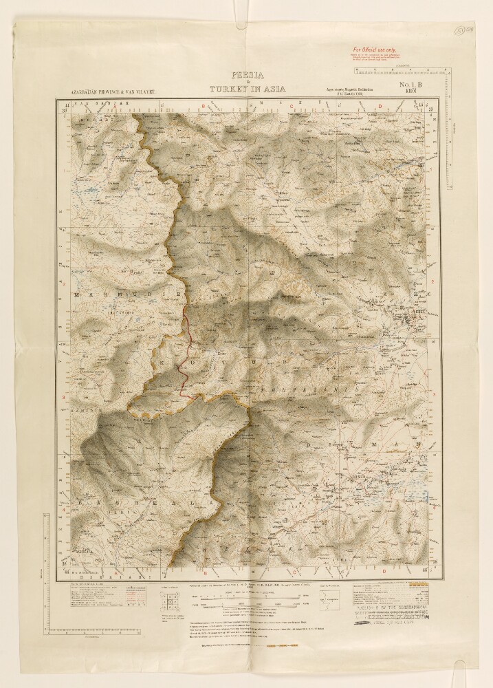
2. ‘Persia & Turkey in Asia’
- Description:
- Abstract: Map numbered 1.B (Khoī [Khoy]), and subtitled ‘Azarbāījān [Azerbaijan] Province & Van Vilayet.’ An index to the geographical location of the provinces is provided below the map. A caption under the map states that it was published under the direction of Colonel Charles Henry Dudley Ryder, Surveyor General of India, 1922. A stamp in the bottom right corner of the map states that it was published by the Geographical Section General Staff, War Office.The map indicates: relief, shown by contours and shading, with elevations given in feet; rivers, lakes, marshes; province and country boundaries; settlements, with place names in English; railways, roads and other transport routes. An additional boundary line, drawn in red ink, has been added to the map.The map is mentioned in a copy of a letter sent by HM’s Envoy Extraordinary and Minister Plenipotentiary at Tehran (Reginald Hervey Hoare) to the Secretary of State for Foreign Affairs (John Allsebrook Simon), dated 1 July 1932, which states that the ‘Turkish military attaché has been so good as to draw upon sheets 1 A, 1 B, and 1 C [...] the line of the new frontier’ (f 48).Physical description: Materials:1 paper folio.Dimensions:464 x 374 mm, on sheet 630 x 444 mm.
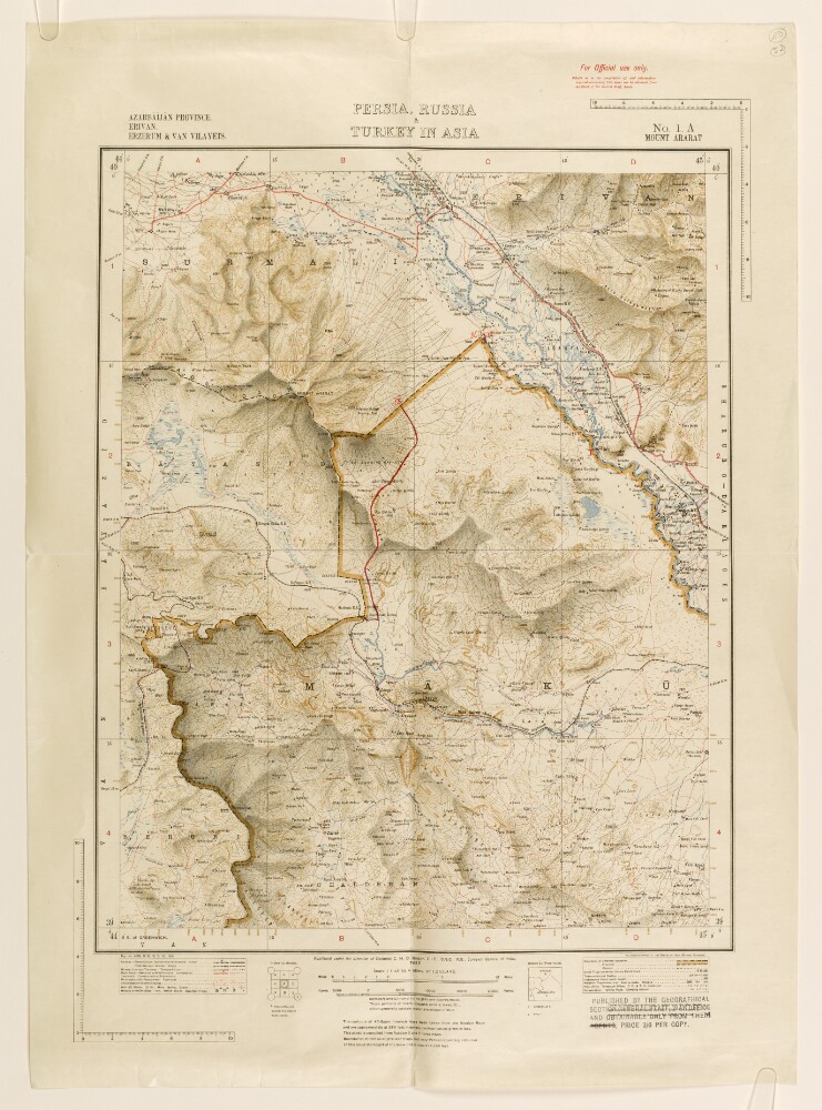
3. ‘Persia, Russia & Turkey in Asia’
- Description:
- Abstract: Map numbered 1.A (Mount Ararat), and subtitled ‘Azarbāījān [Azerbaijan] Province. Erivan [Yerevan]. Erzerum [Erzurum] & Van Vilayets.’ An index to the geographical location of the provinces is provided below the map. A caption under the map states that it was published under the direction of Colonel Charles Henry Dudley Ryder, Surveyor General of India, 1922. A stamp in the bottom right corner of the map states that it was published by the Geographical Section General Staff, War Office.The map indicates: relief, shown by contours and shading, with elevations given in feet; rivers, lakes, marshes; province and country boundaries; settlements, with place names in English; railways, roads and other transport routes; the Indo-European Telegraph Line. A new boundary line, drawn in red ink with annotations, has been added to the map.The map is mentioned in a copy of a letter sent by HM’s Envoy Extraordinary and Minister Plenipotentiary at Tehran (Reginald Hervey Hoare) to the Secretary of State for Foreign Affairs (John Allsebrook Simon), dated 1 July 1932, which states that the ‘Turkish military attaché has been so good as to draw upon sheets 1 A, 1 B, and 1 C [...] the line of the new frontier’ (f 48).Physical description: Materials:1 paper folio.Dimensions:462 x 367 mm, on sheet 615 x 444 mm.

4. PZ 6642/35 Supply of certain War Office and Survey of India maps to the government of Iraq for reprinting in Arabic
- Description:
- Abstract: The file consists of correspondence regarding the supply of certain War Office and Survey of India maps to the Government of Iraq for reprinting in Arabic. It includes a list of maps to be reprinted.The main correspondents include: the Iraqi Ministry for Foreign Affairs, Bagdad [Baghdad]; the British Embassy, Bagdad; HM Ambassador, Bagdad; the Foreign Secretary to the Government of India; the War Office; and the Foreign Office.Physical description: Foliation: the foliation sequence for this description commences at f 1, and terminates at f 25, it is the third file in a larger physical volume, each file has its own foliation sequence; these numbers are written in pencil, and are located in the top right corner of the recto side of each folio.